close
-
Layers w
- Weather Layers
- Pro
- Pro
- Pro
- Pro
- Pro
- Pro
- More Layers
- Pro
- Pro
- Pro
- Pro
-
Upgrade to

3D
Trail Conditions
- Unknown
- Snow Groomed
- Snow Packed
- Snow Covered
- Snow Cover Partial
- Freeze/thaw Cycle
- Icy
- Prevalent Mud
- Wet
- Variable
- Ideal
- Dry
- Very Dry
Trail Flow (Ridden Direction)
Trailforks scans users ridelogs to determine the most popular direction each trail is ridden. A good flowing trail network will have most trails flowing in a single direction according to their intension.
The colour categories are based on what percentage of riders are riding a trail in its intended direction.
The colour categories are based on what percentage of riders are riding a trail in its intended direction.
- > 96%
- > 90%
- > 80%
- > 70%
- > 50%
- < 50%
- bi-directional trail
- no data
Trail Last Ridden
Trailforks scans ridelogs to determine the last time a trail was ridden.
- < 2 days
- < 1 week
- < 2 weeks
- < 1 month
- < 6 months
- > 6 months
Trail Ridden Direction
The intended direction a trail should be ridden.
- Downhill Only
- Downhill Primary
- Both Directions
- Uphill Primary
- Uphill Only
- One Direction
Contribute Details
Colors indicate trail is missing specified detail.
- Description
- Photos
- Description & Photos
- Videos
Trail Popularity ?
Trailforks scans ridelogs to determine which trails are ridden the most in the last 9 months.
Trails are compared with nearby trails in the same city region with a possible 25 colour shades.
Think of this as a heatmap, more rides = more kinetic energy = warmer colors.
- most popular
- popular
- less popular
- not popular
ATV/ORV/OHV Filter
Max Vehicle Width
inches
US Cell Coverage
Legend

Radar Time
Activity Recordings
Trailforks uses anonymized public activity data.
?
Activity Recordings
Trailforks uses anonymized public activity data.
?
Personal Heatmap
▶
Activity Types
all
/
none
▶
Options
2
Date range
month
–
Winter Trails
Warning
A routing network for winter maps does not exist. Selecting trails using the winter trails layer has been disabled.
Missing Trails
Most Popular
Least Popular
Trails are colored based on popularity. The more popular a trail is, the more red. Less popular trails trend towards green.
Jump Magnitude Heatmap
Heatmap of where riders jump on trails. Zoom in to see individual jumps, click circles to view jump details.
BC Backroad Status
![map legend]()
Service Road Atlas is a free to use, community-driven service for viewing and creating reports on the numerous back-country service roads around B.C. and Alberta.

Slope Aspect
Direction the slope faces
Trails Deemphasized
Trails are shown in grey.
Only show trails with no bike usage.
Suggested Layers
Based on selected activity type
Save the current map location and zoom level as your default home location whenever this page is loaded.
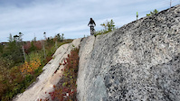
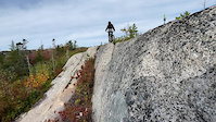
SaveNova Scotia is an ideal province for mountain biking. Downhill, cross country, solid granite all season parks aswell as dirt, mud and gravel. a mixture of adhoc and publicly owned trails and riding areas. Nova scotia has lots of established riding areas aswell has a handfull of new ones either in devlopment or planned for the near future. Trailforks is an awesome way to find them but more are out there just waiting to be mapped.
Stats
- Avg Trail Rating
- Trails (view details)
- 3,098
- Trails Mountain Bike
- 2,544
- Trails E-Bike
- 1,099
- Trails Gravel Bike
- 234
- Trails Adaptive Bike
- 1
- Trails Winter Fat Bike
- 4
- Trails Horse
- 632
- Trails Hike
- 2,915
- Trails Trail Running
- 2,870
- Trails Dirtbike/Moto
- 671
- Trails Observed Trials
- 14
- Trails ATV/ORV/OHV
- 732
- Trails Snowmobile
- 571
- Trails Snowshoe
- 1,991
- Trails Downhill Ski
- 78
- Trails Backcountry Ski
- 141
- Trails Nordic Ski
- 1,125
- Total Distance
- 4,482 miles
- Total Descent
- 281,638 ft
- Total Vertical
- 1,403 ft
- Highest Trailhead
- 1,404 ft
- Reports
- 16,878
- Photos
- 2,388
- Ridden Counter
- 132,616
Articles
The 10 Most Beautiful National Parks in Canada
Jun 17, 2024 from outsideonline.com
Spectacular mountains and deep fjords, powder-blue lakes and sea stacks: here’s your bucket list of national parks to visit up north

Kentville, Nova Scotia Set to Host Canadian XC Championships
Jun 22, 2023 from pinkbike.com
The first time in twenty years that the Canadian Championships will take place in Nova Scotia.
Exploring Atlantic Canada’s Mountain Biking Trails
Aug 10, 2020 from pinkbike.com
The Maritimes on two wheels.
Sub Regions
- Annapolis County (109)
- Cape Breton Island (153)
- County of Inverness (0)
- Victoria County (19)
- Guysborough County (73)
- Halifax Regional Municipality (981)
- Hants Counties (295)
- Kings County (336)
- Lunenburg County (142)
- Northern Nova Scotia (383)
- Queens County (16)
- South West Nova (69)
Popular Nova Scotia Mountain Biking Trails
• 100 ★ 3.8 • 646 ft • 2 ft • 639 •
Short entrance trail to the McIntosh Run system. It leads from the trailhead at the Alabaster Way cul-de-sac, to .
• 100 ★ 4.6 • 2,838 ft • 16 ft • 599 •
is a mix of dirt, granite bedrock and built rock work that is mostly downhill from the Alabaster Way cul-de-sac trailhead. This is a two-way, busy trail with lots of hikers and bikers. Look out for climbers and hikers if descending and...
• 100 ★ 4.8 • 3,396 ft • 27 ft • 586 •
is an entrance trail to the system that starts/finishes at a narrow grass park parcel on Alabaster Way, between #146 and #138. The trail approximately follows the between the Colpitt Lake and McIntosh Run watersheds, and affords great...
• 95 ★ 4.6 • 1 mile • 138 ft • 560 •
Popular blue difficulty singletrack. This multi-use trail can be used both directions and has a moderate overall physical rating with a 138 ft blue climb. It features drop, ladder bridge and rock face. On average it takes 15 minutes to complete this trail.
• 100 ★ 4.6 • 3,071 ft • 58 ft • 520 •
is a mild mannered super hero that starts at Hartlen Park ballfield (on Lois Lane) and extends to Trail. Clark Kent is smooth, has banked turns in places, and has no big climbs. Use it as an entrance to the trail system, or just as a...
• 95 ★ 4.9 • 2 miles • 115 ft • 504 •
Highly rated popular blue difficulty singletrack. This multi-use trail can be used both directions and has a moderate overall physical rating with a 115 ft blue climb. It features berm, bridge, drop, jump, gap jump, ladder bridge and rock face. Trail visibility is always easy to follow. On average it takes 19 minutes to complete this trail.
• 95 ★ 4.5 • 1,535 ft • 11 ft • 486 •
ecmtb.net presents The , a fun little trail using exposed granite segments linked together to create a flat loop. With no real elevation change but lots of undulations, allows you to push the pace if you want -- in either direction....
• 95 ★ 0.0 • 820 ft • 0 ft • 476 •
Wentworth Trails exit for bikes, used to keep downhill traffic off the trail entrance.
Nova Scotia Mountain Bike Routes
★ 4.0 • 33 miles • 1,353 ft • 6 • Out & Back •
This 53km route starts and finishes at the Train Station Bike and Bean. The first leg takes riders east on...
Blue Granite Tour Featured
★ 4.0 • 5 miles • 331 ft • 8 • Loop •
This lollipop route tours the most popular front-country granite trails, with a warm-up/cool down on the...
Granite Fondo 2021 - full monte Featured
★ 4.0 • 21 miles • 1,269 ft • 24 •
Full route for 2021 Granite Fondo * --> --> * Lower Attic --> --> downhill --> straight on...
Dracula Flow Featured
10 miles • 962 ft • 14 • Loop •
Mixed difficulty route with technical trails and logging road climbs. Janky, real janky. Trails in order:...
Granite Fondo Middle Distance 2021 Featured
14 miles • 810 ft • 10 •
Middle distance blue trail route for 2021 Granite Fondo.
Canadian Champs Elite XCO 2024 Featured
4 miles • 380 ft • 13 • Loop •
Proposed route for the 2024 Canadian Championships XCO races July 20-21 2024 in Kentville Nova Scotia....
Photos of Nova Scotia Mountain Bike
Videos of Nova Scotia Mountain Bike
0:12 |
55 |
Oct 26, 2025
0:16 |
48 |
Oct 25, 2025

0:18 |
6 |
Oct 23, 2025

0:02 |
10 |
Oct 19, 2025

trail: Oh Baby!
6:28 |
29 |
Jul 20, 2025

trail: Duck 'n Run
0:05 |
147 |
May 3, 2024
trail: Lou's Basement
0:09 |
125 |
May 3, 2024
trail: Lou's Basement
0:09 |
|
May 3, 2024
Activity Feed
| username | action | type | title | date |
|---|---|---|---|---|
| DanRobin | ridden | trail | activity #96161406 | Jun 3, 2026 @ 9:30am 7 hours |
| SkidsRagnar | add | report | activity #96159712 | Jun 3, 2026 @ 9:04am 8 hours |
| MARCrFNMIq | ridden | trail | activity #96158295 | Jun 3, 2026 @ 8:40am 8 hours |
| dbrownonthego | add | report | activity #96035613 | Jun 1, 2026 @ 12:49pm 2 days |
| vwcabrio82 | add | report | activity #96019190 | Jun 1, 2026 @ 8:27am 2 days |
Recent Comments
| username | type | title | comment | date |
|---|---|---|---|---|
| trail | This Trail has been closed until further... | Jun 1, 2026 @ 8:25am 2 days | ||
| trail | Rode 2nd November; trail is overgrown, bridges... | Nov 2, 2025 @ 11:04am Nov 2, 2025 | ||
| trail | Lots and lots of roots | Oct 19, 2025 @ 7:59am Oct 19, 2025 | ||
| trail | From the White Point beach resort road. Going... | Oct 12, 2025 @ 8:41am Oct 12, 2025 | ||
| trail | The trail surface is well maintained,... | Oct 2, 2025 @ 11:23am Oct 2, 2025 |
Local Badges
-

Catching Out0 awarded -
Tour D'Ingram Finisher12 awarded -

Train Gang's Pipeline Rd. Challenge0 awarded -

Celtic Shores Coastal Trail0 awarded -

Getting Started6 awarded -

Lake Charlotte Century Club2 awarded
Bike & Skill Parks
| name | type | city | rating |
|---|---|---|---|
| Keppoch Mountain | bike park | Antigonish | |
| Wentworth Mountain Bike Park | bike park | Wentworth | |
| Shubie Park Pump Track | skill park | Dartmouth | |
| Chute Park | skill park | Berwick | |
| Mt Edward | skill park | Dartmouth |
Activity Type Stats
| activitytype | trails | distance | descent | descent distance | total vertical | rating | global rank | state rank | photos | reports | routes | ridelogs |
|---|---|---|---|---|---|---|---|---|---|---|---|---|
| Mountain Bike | 2,544 | 3,960 miles | 207,320 ft | 1,572 miles | 1,198 ft | #33 | 2,175 | 16,712 | 100 | 123,712 | ||
| E-Bike | 1,099 | 3,117 miles | 142,657 ft | 1,247 miles | 1,115 ft | #18 | 12 | 9,747 | 27 | 2,731 | ||
| Gravel Bike | 234 | #33 | 16 | 195 | 20 | 1,277 | ||||||
| Adaptive Bike | 1 | #39 | 1 | 5 | ||||||||
| Winter Fat Bike | 4 | #34 | 1 | 8 | 8 | 59 | ||||||
| Horse | 632 | 2,806 miles | 110,039 ft | 1,122 miles | 1,115 ft | #13 | 3,280 | 32 | ||||
| Hike | 2,915 | 4,383 miles | 244,744 ft | 1,721 miles | 1,404 ft | #31 | 152 | 16,561 | 21 | 16,398 | ||
| Trail Running | 2,870 | 4,342 miles | 240,433 ft | 1,704 miles | 1,404 ft | #30 | 5 | 16,484 | 19 | 11,335 | ||
| Dirtbike/Moto | 671 | 2,549 miles | 107,221 ft | 1,004 miles | 991 ft | #11 | 5 | 3,382 | 3 | 223 | ||
| Observed Trials | 14 | 34 miles | 1,273 ft | 13 miles | 791 ft | #19 | 18 | 61 | 39 | |||
| ATV/ORV/OHV | 732 | 3,081 miles | 120,525 ft | 1,226 miles | 1,115 ft | #8 | 3,433 | 4 | 234 | |||
| Snowmobile | 571 | 2,670 miles | 98,901 ft | 1,048 miles | 1,115 ft | #5 | 1,062 | 1 | 4 | |||
| Snowshoe | 1,991 | 3,283 miles | 168,179 ft | 1,253 miles | 1,342 ft | #8 | 5 | 4,172 | 10 | 917 | ||
| Downhill Ski | 78 | 52 miles | 18,668 ft | 30 miles | 958 ft | #28 | 134 | 1,541 | ||||
| Backcountry Ski | 141 | 324 miles | 17,785 ft | 143 miles | 958 ft | #18 | 726 | 1 | 210 | |||
| Nordic Ski | 1,125 | 2,684 miles | 112,749 ft | 1,019 miles | 1,115 ft | #7 | 8 | 2,704 | 4 | 1,250 |
Activities
- Nova Scotia Mountain Biking Trails
- Nova Scotia E-Biking Trails
- Nova Scotia Gravel Biking Trails
- Nova Scotia Horseback Trails
- Nova Scotia Hiking Trails
- Nova Scotia Trail Running Trails
- Nova Scotia Dirtbiking Trails
- Nova Scotia Observed Trials Trails
- Nova Scotia ATVing/Offroading Trails
- Nova Scotia Snowmobiling Trails
- Nova Scotia Snowshoeing Trails
- Nova Scotia Skiing Trails
- Nova Scotia Backcountry Skiing Trails
- Nova Scotia Nordic Skiing Trails
Trails
Points of Interest
- Visitor Pavillion Information
- Morrison's Rock Sight
- Fiona's Rock TTF
- [waterfall] Wards Falls Other
- [waterfall] Spencer Brook Falls Other
- [waterfall] Liscomb River falls Other
- [waterfall] James River Falls Other
- [waterfall] Black Hole Falls Other
- Beeswanger Dam Bridge
- Fish River Bridge
- White Hill (1,745 ft)
- The Pinnacle (1,706 ft)
- By canadaka
 Trailforks & contributors
 - Admins: IMBA Canada, brenthillier, adaptivemike, maddy03, bent6543
- #3160 - 90,862 views
- nova scotia activity log | embed map of Nova Scotia mountain bike trails | nova scotia mountain biking points of interest polygons
Downloading of trail gps tracks in kml & gpx formats is enabled for Nova Scotia.
You must login to download files.