close
-
Layers w
- Weather Layers
- Pro
- Pro
- Pro
- Pro
- Pro
- Pro
- More Layers
- Pro
- Pro
- Pro
- Pro
-
Upgrade to

3D
Trail Conditions
- Unknown
- Snow Groomed
- Snow Packed
- Snow Covered
- Snow Cover Partial
- Freeze/thaw Cycle
- Icy
- Prevalent Mud
- Wet
- Variable
- Ideal
- Dry
- Very Dry
Trail Flow (Ridden Direction)
Trailforks scans users ridelogs to determine the most popular direction each trail is ridden. A good flowing trail network will have most trails flowing in a single direction according to their intension.
The colour categories are based on what percentage of riders are riding a trail in its intended direction.
The colour categories are based on what percentage of riders are riding a trail in its intended direction.
- > 96%
- > 90%
- > 80%
- > 70%
- > 50%
- < 50%
- bi-directional trail
- no data
Trail Last Ridden
Trailforks scans ridelogs to determine the last time a trail was ridden.
- < 2 days
- < 1 week
- < 2 weeks
- < 1 month
- < 6 months
- > 6 months
Trail Ridden Direction
The intended direction a trail should be ridden.
- Downhill Only
- Downhill Primary
- Both Directions
- Uphill Primary
- Uphill Only
- One Direction
Contribute Details
Colors indicate trail is missing specified detail.
- Description
- Photos
- Description & Photos
- Videos
Trail Popularity ?
Trailforks scans ridelogs to determine which trails are ridden the most in the last 9 months.
Trails are compared with nearby trails in the same city region with a possible 25 colour shades.
Think of this as a heatmap, more rides = more kinetic energy = warmer colors.
- most popular
- popular
- less popular
- not popular
ATV/ORV/OHV Filter
Max Vehicle Width
inches
US Cell Coverage
Legend

Radar Time
Activity Recordings
Trailforks uses anonymized public activity data.
?
Activity Recordings
Trailforks uses anonymized public activity data.
?
Personal Heatmap
▶
Activity Types
all
/
none
▶
Options
2
Date range
month
–
Winter Trails
Warning
A routing network for winter maps does not exist. Selecting trails using the winter trails layer has been disabled.
Missing Trails
Most Popular
Least Popular
Trails are colored based on popularity. The more popular a trail is, the more red. Less popular trails trend towards green.
Jump Magnitude Heatmap
Heatmap of where riders jump on trails. Zoom in to see individual jumps, click circles to view jump details.
BC Backroad Status
![map legend]()
Service Road Atlas is a free to use, community-driven service for viewing and creating reports on the numerous back-country service roads around B.C. and Alberta.

Slope Aspect
Direction the slope faces
Trails Deemphasized
Trails are shown in grey.
Only show trails with no bike usage.
Suggested Layers
Based on selected activity type
Save the current map location and zoom level as your default home location whenever this page is loaded.
Save
No description for Ojai has been added yet!
Login or register to submit one.
Activities Click to view
- Mountain Bike
72 trails
- E-Bike
12 trails
- Gravel Bike
0 trails
- Winter Fat Bike
0 trails
- Horse
23 trails
- Hike
91 trails
- Trail Running
91 trails
- Dirtbike/Moto
4 trails
Region Details
- 19
- 16
- 24
- 12
- 1
Region Status
Caution as of Apr 25, 2026Stats
- Avg Trail Rating
- Trails (view details)
- 88
- Trails Mountain Bike
- 72
- Trails E-Bike
- 12
- Trails Horse
- 23
- Trails Hike
- 91
- Trails Trail Running
- 91
- Trails Dirtbike/Moto
- 4
- Trails Observed Trials
- 1
- Trails ATV/ORV/OHV
- 2
- Total Distance
- 323 miles
- Total Descent
- 59,284 ft
- Total Vertical
- 7,262 ft
- Highest Trailhead
- 7,487 ft
- Reports
- 444
- Photos
- 392
- Ridden Counter
- 7,173
Sub Regions
-
Ventura River Preserve
- 11
- 13
- 2
- 1
Popular Ojai Mountain Biking Trails
• 100 ★ 3.8 • 5 miles • 125 ft • 328 •
One of the most popular trails in Ojai. An out and back trail ride with an extremely fun long/challenging flowy decent. Being that you must climb to get to the top don't bring your DH bike but also I would not recommend a hard tail...
• 100 ★ 3.8 • 15 miles • 2,792 ft • 279 •
This is a very good and well maintained fire road with a few small single tracks mixed in between. If you are looking for a nice fire road ride with great views and relaxing, nothing technical terain then this is the trail for you.
• 95 ★ 4.0 • 2,126 ft • 0 ft • 230 •
Gridley trail starts in Ojai at the north end of Road and ends on top of Nordhoff Ridge. This short lower section of trail is quite a bit more technical than the rest of the trail containing steep rock gardens and some exposure. Beyond...
• 100 ★ 0.0 • 4,367 ft • 8 ft • 225 •
Popular green difficulty singletrack. This mountain bike primary trail can be used both directions and has a moderate overall physical rating with a 8 ft green climb. On average it takes 7 minutes to complete this trail.
• 90 ★ 4.0 • 2 miles • 585 ft • 204 •
This is a great xc trail and can be made into an awesome loop if you keep going and link it with . Not too long, not too steep but you can push your self as hard as you want. There are many other single tracks in this area that can be...
• 90 ★ 3.4 • 1,660 ft • 223 ft • 179 •
Popular blue difficulty singletrack. This mountain bike primary trail can be used both directions and has a hard overall physical rating with a 223 ft black diamond climb. On average it takes 7 minutes to complete this trail.
• 95 ★ 4.0 • 2 miles • 127 ft • 175 •
(Rice Ridge) is best run from the top of / down and ending at near the start of . It can be ridden the other direction uphill, but there will be some hiking section unless you are a beast. This trail is in the midst of fundraising to...
• 85 ★ 0.0 • 1,005 ft • 7 ft • 171 •
Popular green difficulty singletrack. This mountain bike primary trail can be used both directions and has a easy overall physical rating with a 7 ft green climb. On average it takes 1 minutes to complete this trail.
Ojai Mountain Bike Routes
★ 4.5 • 8 miles • 1,483 ft • 1 • Loop •
Technical ascent up to slightly less technical ascent up Foothill Trail. More mellow single track...
6 miles • 771 ft • 4 •
Short loop - Oso Ridge back via Willis Canyon
★ 1.0 • 8 miles • 1,645 ft • 3 • Loop •
Difficult ascent up followed by a sustained ascent of Pratt Trail (Fireroad). Descend l (Fireroad) and...
5 miles • 415 ft • 0 • Loop •
Easy loop on mixed surfaces (pavement, dirt road) featuring a view of the Ojai Valley from Shelf Road.
• 6 miles • 606 ft • 5 •
Photos of Ojai Mountain Bike
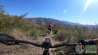
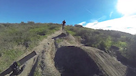
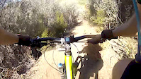
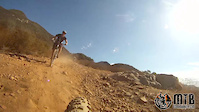
Videos of Ojai Mountain Bike
trail: Rice Canyon
0:46 |
41 |
Mar 30, 2021
4:36 |
97 |
Mar 30, 2021
trail: Kennedy Ridge
5:43 |
86 |
Mar 29, 2021
trail: Ridge Runner
3:43 |
59 |
Mar 29, 2021
trail: Prisoners
2:03 |
789 |
Dec 30, 2014
trail: Gridley
26:08 |
582 |
Sep 7, 2014
trail: Gridley
26:20 |
309 |
Sep 7, 2014
Recent Trail Reports
| status | trail | date | condition | info | user |
|---|---|---|---|---|---|
| Sulfur Mountain | Apr 25, 2026 @ 9:29am (America/Los_Angeles) Apr 25, 2026 | Ideal | Zieglebeet | ||
| Wills Canyon to Cooper Canyon | Mar 13, 2026 @ 4:13pm (America/Los_Angeles) Mar 13, 2026 | Unknown | Jefezplt | ||
| Pratt Downhill | Mar 7, 2026 @ 2:49pm (America/Los_Angeles) Mar 7, 2026 | Ideal | MHartong | ||
| Portrero Seco Road | Mar 4, 2026 @ 12:28pm (America/Los_Angeles) Mar 4, 2026 | Very Dry | gimafi | ||
| Sisar Canyon | Jan 18, 2026 @ 9:17am (America/Los_Angeles) Jan 18, 2026 | Ideal | SparkeyCA | ||
| Red Reef | Dec 13, 2025 @ 5:59am (America/Los_Angeles) Dec 13, 2025 | Ideal | Huerta32 | ||
| Gridley | Dec 13, 2025 @ 8:38am (America/Los_Angeles) Dec 13, 2025 | Ideal | FlowRips | ||
| Rice Wills | Aug 12, 2025 @ 3:17pm Aug 12, 2025 | Dry | dclarkmtb | ||
| River View Trailhead | Jul 8, 2025 @ 9:54am Jul 8, 2025 | Dry | JamesAgepoguyiu | ||
| Wills Crossover | Jul 8, 2025 @ 9:54am Jul 8, 2025 | Dry | JamesAgepoguyiu |
Activity Feed
| username | action | type | title | date |
|---|---|---|---|---|
| ralph721 | wishlist | trail | activity #96367796 | Jun 6, 2026 @ 7:22am Jun 6, 2026 |
| mdemd | ridden | trail | activity #96013306 | Jun 1, 2026 @ 6:31am Jun 1, 2026 |
| WitteWel | add | photo | activity #95977781 and 14 more | May 31, 2026 @ 2:21pm May 31, 2026 |
| WitteWel | comment | trail | activity #95977697 | May 31, 2026 @ 2:20pm May 31, 2026 |
| WitteWel | ridden | trail | activity #95977472 and 4 more | May 31, 2026 @ 2:18pm May 31, 2026 |
Recent Comments
| username | type | title | comment | date |
|---|---|---|---|---|
| trail | This is a fun trail. There a few (3) places... | May 31, 2026 @ 2:20pm May 31, 2026 | ||
| trail | Running OK. A few places are blown out and... | May 4, 2026 @ 9:47am May 4, 2026 | ||
| report | Very nice condition. A few ticks so check... | Apr 20, 2026 @ 5:51am Apr 20, 2026 | ||
| trail | I couldn't get across the river in any of the... | Mar 28, 2026 @ 7:12am Mar 28, 2026 | ||
| trail | There are some washed out sections near the... | Mar 22, 2026 @ 3:13pm Mar 22, 2026 |
Local Badges
-

10 Green Trails70 awarded -

Epic Ride Climb 2k176 awarded -

Climbing 10k Badge64 awarded -

Climbing 100k Badge7 awarded -

Epic Ride Descent 2k182 awarded -

Descent 10k Badge63 awarded
Local Trail Supporters
- Los Padres Trail Stewards
Activity Type Stats
| activitytype | trails | distance | descent | descent distance | total vertical | rating | global rank | state rank | photos | reports | routes | ridelogs |
|---|---|---|---|---|---|---|---|---|---|---|---|---|
| Mountain Bike | 72 | 234 miles | 42,881 ft | 107 miles | 6,913 ft | #929 | #363 | 375 | 444 | 5 | 10,893 | |
| E-Bike | 12 | 54 miles | 9,065 ft | 24 miles | 5,427 ft | #2,886 | #1,092 | 6 | 301 | 3 | 1,146 | |
| Horse | 23 | 141 miles | 21,873 ft | 62 miles | 5,820 ft | #293 | #455 | 93 | ||||
| Hike | 91 | 322 miles | 58,730 ft | 147 miles | 7,264 ft | #418 | #193 | 12 | 434 | 1 | 1,136 | |
| Trail Running | 91 | 322 miles | 58,730 ft | 147 miles | 7,264 ft | #410 | #162 | 434 | 1 | 364 | ||
| Dirtbike/Moto | 4 | 22 miles | 3,100 ft | 10 miles | 3,071 ft | #871 | #322 | 67 | 1 | |||
| Observed Trials | 1 | 2 miles | 1,572 ft | 6 | 1 | |||||||
| ATV/ORV/OHV | 2 | 11 miles | 1,339 ft | 5 miles | 1,906 ft | 62 |
Frequently Asked Questions About Ojai
▼
What are the best places to ride in Ojai?
Ojai has 2 areas to explore for mountain biking. The top rated areas are:
▼
What are the highest rated mountain biking trails in Ojai?
The highest rated mountain biking trails in Ojai are:
- El Nido Trail (4.2/5)
- Chorro Grande Trail (4.2/5)
- Prisoners (4.2/5)
- Boulder Canyon Trail (4.1/5)
- Loons Den (4.1/5)
▼
What is the best time of the year to ride in Ojai?
Based on ride log data, the most popular months to ride in Ojai are:
- July (74 activities)
- May (68 activities)
- November (66 activities)
▼
Where can I park to ride in Ojai?
There are 13 parking locations listed in Ojai. The most popular parking spots are: View all parking and trailhead locations on the map to plan your visit.
Activities
Trails
Points of Interest
- Nordhoff Peak Lookout Tower Viewpoint
- Reyes Creek Campground Camping
- Bear Creek Camp Camping
- Oak Flat Campsite Camping
- Willet Campsite Camping
- Coltrell Flat Camping
- Sespe Hot Springs Sight
- Shady Campsite Camping
- Ladybug Campsite Camping
- East Fork Lion Camp Camping
- Reyes Peak (7,493 ft)
- Haddock Mountain (7,421 ft)
- Thorn Point (6,923 ft)
- By ClayN
 & contributors
 - Admins: STA, mtbcommunity-com
- #7521 - 15,684 views
- ojai activity log | embed map of Ojai mountain bike trails | ojai mountain biking points of interest
Downloading of trail gps tracks in kml & gpx formats is enabled for Ojai.
You must login to download files.