close
-
Layers w
- Weather Layers
- Pro
- Pro
- Pro
- Pro
- Pro
- Pro
- More Layers
- Pro
- Pro
- Pro
- Pro
-
Upgrade to

3D
Trail Conditions
- Unknown
- Snow Groomed
- Snow Packed
- Snow Covered
- Snow Cover Partial
- Freeze/thaw Cycle
- Icy
- Prevalent Mud
- Wet
- Variable
- Ideal
- Dry
- Very Dry
Trail Flow (Ridden Direction)
Trailforks scans users ridelogs to determine the most popular direction each trail is ridden. A good flowing trail network will have most trails flowing in a single direction according to their intension.
The colour categories are based on what percentage of riders are riding a trail in its intended direction.
The colour categories are based on what percentage of riders are riding a trail in its intended direction.
- > 96%
- > 90%
- > 80%
- > 70%
- > 50%
- < 50%
- bi-directional trail
- no data
Trail Last Ridden
Trailforks scans ridelogs to determine the last time a trail was ridden.
- < 2 days
- < 1 week
- < 2 weeks
- < 1 month
- < 6 months
- > 6 months
Trail Ridden Direction
The intended direction a trail should be ridden.
- Downhill Only
- Downhill Primary
- Both Directions
- Uphill Primary
- Uphill Only
- One Direction
Contribute Details
Colors indicate trail is missing specified detail.
- Description
- Photos
- Description & Photos
- Videos
Trail Popularity ?
Trailforks scans ridelogs to determine which trails are ridden the most in the last 9 months.
Trails are compared with nearby trails in the same city region with a possible 25 colour shades.
Think of this as a heatmap, more rides = more kinetic energy = warmer colors.
- most popular
- popular
- less popular
- not popular
ATV/ORV/OHV Filter
Max Vehicle Width
inches
US Cell Coverage
Legend

Radar Time
Activity Recordings
Trailforks uses anonymized public activity data.
?
Activity Recordings
Trailforks uses anonymized public activity data.
?
Personal Heatmap
▶
Activity Types
all
/
none
▶
Options
2
Date range
month
–
Winter Trails
Warning
A routing network for winter maps does not exist. Selecting trails using the winter trails layer has been disabled.
Missing Trails
Most Popular
Least Popular
Trails are colored based on popularity. The more popular a trail is, the more red. Less popular trails trend towards green.
Jump Magnitude Heatmap
Heatmap of where riders jump on trails. Zoom in to see individual jumps, click circles to view jump details.
BC Backroad Status
![map legend]()
Service Road Atlas is a free to use, community-driven service for viewing and creating reports on the numerous back-country service roads around B.C. and Alberta.

Slope Aspect
Direction the slope faces
Trails Deemphasized
Trails are shown in grey.
Only show trails with no bike usage.
Suggested Layers
Based on selected activity type
Save the current map location and zoom level as your default home location whenever this page is loaded.
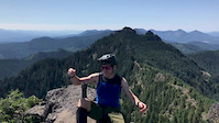
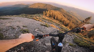
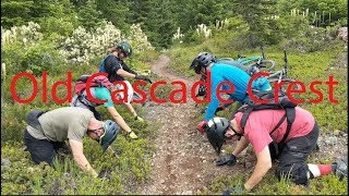
SaveDeep backcountry riding on the west side of the Cascade Peaks, particularly Three-Fingered Jack and Mt. Jefferson. Nestled between the Middle Santiam Wilderness to the west and the Jefferson Wilderness to the east, this region offers a number of big-mountain riding experiences up and over multiple ancient peaks that were once the high points of the Cascades, prior to the emergence of the new peaks.
The network is mostly a giant lollipop route going up and over Crescent Mountain from the Lava Lakes Sno-Park. It can also be ridden as a big loop, or as a variety of different out-and-back or point-to-point segments that largely consist of going to the very top of a steep mountain and then riding back down or off the other side.
Paved and gravel roads run through the middle of the network. The roads are open to vehicles, but "shuttling" in this system consists more of logistical staging of vehicles at strategic locations, particularly to enable point-to-point riding. These are not "shuttle trails" in the classic sense of being driven to the top and riding down.
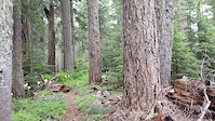
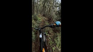
Primary Trail Type: All-Mountain & Downhill
Shuttleable: YES
AKA: Pyramids
Land Status: National Forest
 google parking directions
 Access Info:
Lava Lakes Sno-Park just north of Highway 20 and just west of intersections with Highway 22 and Highway 126. Other access points exist off Highway 22 from the east and north of the system.
Links
Activities Click to view
- Mountain Bike
25 trails
- Horse
8 trails
- Hike
27 trails
- Trail Running
27 trails
Region Details
- 15
- 1
- 8
- 9
- 1
Region Status
Caution as of Jun 9, 2026Stats
- Avg Trail Rating
- Trails (view details)
- 34
- Trails Mountain Bike
- 25
- Trails E-Bike
- 2
- Trails Horse
- 8
- Trails Hike
- 27
- Trails Trail Running
- 27
- Total Distance
- 54 miles
- Total Descent
- 12,470 ft
- Total Vertical
- 3,878 ft
- Highest Trailhead
- 5,771 ft
- Reports
- 210
- Photos
- 66
- Ridden Counter
- 1,348
Popular Old Cascade Crest Mountain Biking Trails
• 100 ★ 4.0 • 4 miles • 110 ft • 160 •
Highly rated popular black diamond difficulty singletrack. This multi-use trail. On average it takes 38 minutes to complete this trail.
• 100 ★ 4.7 • 4 miles • 18 ft • 148 •
Highly rated popular black diamond difficulty singletrack. This mountain bike primary trail. On average it takes 1 hour11 minutes to complete this trail.
• 90 ★ 5.0 • 2 miles • 31 ft • 119 •
Popular blue difficulty singletrack. This multi-use trail. On average it takes 19 minutes to complete this trail.
• 80 ★ 4.0 • 5 miles • 920 ft • 103 •
Popular black diamond difficulty singletrack. This multi-use trail can be used both directions and has a moderate overall physical rating with a 920 ft blue climb. On average it takes 55 minutes to complete this trail.
• 85 ★ 5.0 • 5 miles • 1,837 ft • 100 •
Popular blue difficulty singletrack. This multi-use trail. On average it takes 1 hour47 minutes to complete this trail.
• 100 ★ 3.0 • 1 mile • 86 ft • 97 •
Popular blue difficulty singletrack. This multi-use trail. On average it takes 12 minutes to complete this trail.
• 90 ★ 4.4 • 7 miles • 1,042 ft • 93 •
The northern portion of this trail is followed by the Hood Tier of the Oregon Timber Trail.
• 85 ★ 4.4 • 3 miles • 147 ft • 85 •
Popular black diamond difficulty singletrack. This multi-use trail. On average it takes 28 minutes to complete this trail.
Old Cascade Crest Mountain Bike Routes
★ 4.5 • 27 miles • 7,216 ft • 8 • Loop •
Starting from the Crescent Mountain, North/South Pyramid Trailhead this loop was done clockwise. See...
3 miles • 80 ft • 1 •
This black-diamond stretch of rugged singletrack is technical and a long way from the hospital, so always...
• 22 miles • 4,420 ft • 5 •
• 9 miles • 2,404 ft • 1 •
• 19 miles • 3,299 ft • 3 •
• 9 miles • 2,106 ft • 1 •
Photos of Old Cascade Crest Mountain Bike
Videos of Old Cascade Crest Mountain Bike
trail: Pyramids Trail
0:25 |
233 |
Jul 26, 2019
trail: Gordan Peak
0:09 |
119 |
Jul 1, 2019

trail: Pyramid Horse Camp Spur
2:16 |
235 |
Oct 4, 2022 , Sweet Home
trail: Crescent Mountain South
2:58 |
387 |
Oct 4, 2022 , Sweet Home
trail: Coffin Lookout Trail
4:09 |
385 |
Oct 4, 2022 , Sweet Home
youtuber
![VOTR Old Cascade Crest with Trans Cascadia...]()

trail: Scar Mountain
16:48 |
604 |
Jan 7, 2020 , Sweet Home
youtuber
![VOTR-Old Cascade Crest with Trans Cascadia...]()
trail: North Pyramids
16:48 |
455 |
Jan 7, 2020 , Sweet Home
youtuber
![VOTR-Old Cascade Crest with Trans Cascadia...]()

trail: Pyramids Trail
16:48 |
760 |
Jan 7, 2020 , Sweet Home
Current Trail Warnings
| status | trail | date | condition | user | info |
|---|---|---|---|---|---|
| Chimney Peak Trail | Jun 9, 2026 @ 12:13am (America/Los_Angeles) Jun 9, 2026 | Dry | joemyers COTA | Southern 3/4 mile cleared by NWSAW. Quite... | |
| North Pyramids | May 25, 2026 @ 7:38am (America/Los_Angeles) May 25, 2026 | Ideal | tonloc2344 | Lots of blowdown. We made it to within a... | |
| Gordan Peak | May 23, 2026 @ 7:13am (America/Los_Angeles) May 23, 2026 | Dry | joemyers COTA | Workers from CV, Cota, NWTA etc worked on... |
Recent Trail Reports
| status | trail | date | condition | info | user |
|---|---|---|---|---|---|
| Scar Mountain | Jun 9, 2026 @ 12:16am (America/Los_Angeles) Jun 9, 2026 | Dry | joemyers COTA | ||
| South Pyramid Creek - West | Jun 9, 2026 @ 12:12am (America/Los_Angeles) Jun 9, 2026 | Dry | joemyers COTA | ||
| Pyramid Horse Camp Spur | Jun 9, 2026 @ 12:12am (America/Los_Angeles) Jun 9, 2026 | Ideal | joemyers COTA | ||
| South Pyramid Creek - East | May 26, 2026 @ 8:34am (America/Los_Angeles) May 26, 2026 | Ideal | Davidgissiner | ||
| Crescent Mountain North | May 26, 2026 @ 8:33am (America/Los_Angeles) May 26, 2026 | Ideal | Davidgissiner | ||
| Pyramids Trail | Aug 10, 2025 @ 7:30pm Aug 10, 2025 | Dry | dahlbaek | ||
| Crescent Mountain South | Aug 10, 2025 @ 6:45am Aug 10, 2025 | Dry | dahlbaek | ||
| Swamp Peak Trail | Sep 23, 2024 @ 1:49pm Sep 23, 2024 | Variable | tbmaddux Team Dirt | ||
| NF560 | Sep 21, 2024 @ 11:42pm Sep 21, 2024 | Ideal | tifuy | ||
| Access Trail | Sep 16, 2022 @ 10:51am Sep 16, 2022 | Snow Cover Partial | DavidUmxEc3 |
Activity Feed
| username | action | type | title | date |
|---|---|---|---|---|
| Joseph7WWvJV | wishlist | region | activity #97055637 | Jun 15, 2026 @ 11:34am 2 days |
| rippnmon | vote | trail | activity #97048673 | Jun 15, 2026 @ 9:54am 2 days |
| joemyers | add | report | activity #96588562 and 3 more | Jun 9, 2026 @ 12:12am Jun 9, 2026 |
| SarahthCfaM | wishlist | region | activity #96415200 | Jun 6, 2026 @ 4:36pm Jun 6, 2026 |
| Davidgissiner | add | report | activity #95566743 and 1 more | May 26, 2026 @ 8:33am May 26, 2026 |
Recent Comments
| username | type | title | comment | date |
|---|---|---|---|---|
| trail | I tried to access this road from the south. It... | Nov 16, 2025 @ 7:11am Nov 16, 2025 | ||
| trail | Trail is in great shape. Crew was out clearing... | Jun 28, 2025 @ 4:17pm Jun 28, 2025 | ||
| trail | Two logs across the trail that need to be... | Jun 5, 2024 @ 10:39pm Jun 5, 2024 | ||
| trail | Gracias. | Oct 13, 2023 @ 8:15pm Oct 13, 2023 | ||
| trail | If you are, however, the type of rider who... | Sep 11, 2023 @ 4:55pm Sep 11, 2023 |
Nearby Areas
| name | distance | ||||
|---|---|---|---|---|---|
| Santiam Wagon Trail | 5 | 4 | 2 | 9.1 km | |
| Santiam State Forest | 10 | 18.5 km | |||
| Cache Mountain | 19.1 km | ||||
| Suttle Lake | 7 | 1 | 20 km | ||
| McKenzie River | 5 | 2 | 22.5 km |
Local Badges
-

Completionist0 awarded
Activity Type Stats
| activitytype | trails | distance | descent | descent distance | total vertical | rating | global rank | state rank | photos | reports | routes | ridelogs |
|---|---|---|---|---|---|---|---|---|---|---|---|---|
| Mountain Bike | 25 | 54 miles | 12,470 ft | 25 miles | 3,878 ft | #4,282 | #1,511 | 64 | 210 | 2 | 923 | |
| E-Bike | 2 | 48 | 20 | |||||||||
| Horse | 8 | #3,510 | #2,113 | 72 | ||||||||
| Hike | 27 | 54 miles | 12,470 ft | 25 miles | 3,878 ft | #4,316 | #1,539 | 2 | 210 | 62 | ||
| Trail Running | 27 | 54 miles | 12,470 ft | 25 miles | 3,878 ft | #3,626 | #993 | 210 | 23 |
Frequently Asked Questions About Old Cascade Crest
▼
What are the highest rated mountain biking trails in Old Cascade Crest?
The highest rated mountain biking trails in Old Cascade Crest are:
- Crescent Mountain North (4.3/5)
- Gordan Peak (4.2/5)
- South Pyramid Creek - West (4.1/5)
- North Pyramids (4.1/5)
- Scar Mountain (4.1/5)
▼
What is the best time of the year to ride in Old Cascade Crest?
Based on ride log data, the most popular months to ride in Old Cascade Crest are:
- July (25 activities)
- June (17 activities)
- August (15 activities)
▼
Where can I park to ride in Old Cascade Crest?
There are 9 parking locations listed in Old Cascade Crest. The most popular parking spots are: View all parking and trailhead locations on the map to plan your visit.
▼
What is the longest trail in Old Cascade Crest?
The longest trail in Old Cascade Crest is Daly Lake Trail at 49.1 miles. View all trails sorted by distance.
Activities
Trails
- By BenLovesIdaho & contributors
- Admins: apply
- #9138 - 11,951 views
- old cascade crest activity log | embed map of Old Cascade Crest mountain bike trails | old cascade crest mountain biking points of interest
Downloading of trail gps tracks in kml & gpx formats is enabled for Old Cascade Crest.
You must login to download files.