close
-
Layers w
- Weather Layers
- Pro
- Pro
- Pro
- Pro
- Pro
- Pro
- More Layers
- Pro
- Pro
- Pro
- Pro
-
Upgrade to

3D
Trail Conditions
- Unknown
- Snow Groomed
- Snow Packed
- Snow Covered
- Snow Cover Partial
- Freeze/thaw Cycle
- Icy
- Prevalent Mud
- Wet
- Variable
- Ideal
- Dry
- Very Dry
Trail Flow (Ridden Direction)
Trailforks scans users ridelogs to determine the most popular direction each trail is ridden. A good flowing trail network will have most trails flowing in a single direction according to their intension.
The colour categories are based on what percentage of riders are riding a trail in its intended direction.
The colour categories are based on what percentage of riders are riding a trail in its intended direction.
- > 96%
- > 90%
- > 80%
- > 70%
- > 50%
- < 50%
- bi-directional trail
- no data
Trail Last Ridden
Trailforks scans ridelogs to determine the last time a trail was ridden.
- < 2 days
- < 1 week
- < 2 weeks
- < 1 month
- < 6 months
- > 6 months
Trail Ridden Direction
The intended direction a trail should be ridden.
- Downhill Only
- Downhill Primary
- Both Directions
- Uphill Primary
- Uphill Only
- One Direction
Contribute Details
Colors indicate trail is missing specified detail.
- Description
- Photos
- Description & Photos
- Videos
Trail Popularity ?
Trailforks scans ridelogs to determine which trails are ridden the most in the last 9 months.
Trails are compared with nearby trails in the same city region with a possible 25 colour shades.
Think of this as a heatmap, more rides = more kinetic energy = warmer colors.
- most popular
- popular
- less popular
- not popular
ATV/ORV/OHV Filter
Max Vehicle Width
inches
US Cell Coverage
Legend

Radar Time
Activity Recordings
Trailforks uses anonymized public activity data.
?
Activity Recordings
Trailforks uses anonymized public activity data.
?
Personal Heatmap
▶
Activity Types
all
/
none
▶
Options
2
Date range
month
–
Winter Trails
Warning
A routing network for winter maps does not exist. Selecting trails using the winter trails layer has been disabled.
Missing Trails
Most Popular
Least Popular
Trails are colored based on popularity. The more popular a trail is, the more red. Less popular trails trend towards green.
Jump Magnitude Heatmap
Heatmap of where riders jump on trails. Zoom in to see individual jumps, click circles to view jump details.
BC Backroad Status
![map legend]()
Service Road Atlas is a free to use, community-driven service for viewing and creating reports on the numerous back-country service roads around B.C. and Alberta.

Slope Aspect
Direction the slope faces
Trails Deemphasized
Trails are shown in grey.
Only show trails with no bike usage.
Suggested Layers
Based on selected activity type
Save the current map location and zoom level as your default home location whenever this page is loaded.
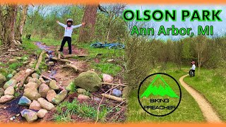
SaveOlson Park is a novice to moderate trail. It provides numerous trail options, including a continuous perimeter loop, as well as opportunities to play around on various connectors and detours. There is a mix of hard pack, some sand traps and wet areas (part goes around a pond), as it’s a former gravel pit. There are some bluffs with a good climb, some log jumps and several stretches of tight switchbacks. The Olson Park trail is the northern most portion of the unofficial Ann Arbor Local Loop trail network. With a little investigation, a rider can connect to 10+ miles of additional trails.
 google parking directions
 Access Info:
Take M-14 westbound to the Barton Drive Exit. Go east to Pontiac Trail, left (North-ish), to Dhu Varren Road. There is a big paved parking lot off of Dhu Varren Road
Activities Click to view
- Mountain Bike
12 trails
- Hike
12 trails
- Trail Running
12 trails
Region Details
- 4
- 4
- 4
Region Status
Open as of Jul 7, 2025Stats
- Avg Trail Rating
- Trails (view details)
- 12
- Trails Mountain Bike
- 12
- Trails Hike
- 12
- Trails Trail Running
- 12
- Total Distance
- 5 miles
- Total Descent Distance
- 1 mile
- Total Descent
- 167 ft
- Total Vertical
- 42 ft
- Highest Trailhead
- 939 ft
- Reports
- 53
- Photos
- 12
- Ridden Counter
- 1,291
Popular Olson Park Mountain Biking Trails
• 95 ★ 3.8 • 1 mile • 57 ft • 162 •
Popular blue difficulty singletrack. This multi-use trail can be used one direction. On average it takes 12 minutes to complete this trail.
• 100 ★ 0.0 • 2,569 ft • 24 ft • 132 •
Popular blue difficulty singletrack. This multi-use trail can be used both directions. On average it takes 3 minutes to complete this trail.
• 90 ★ 0.0 • 1,949 ft • 25 ft • 120 •
Popular green difficulty singletrack. This multi-use trail can be used one direction. On average it takes 2 minutes to complete this trail.
• 95 ★ 0.0 • 1,004 ft • 5 ft • 111 •
Popular green difficulty singletrack. This multi-use trail can be used one direction. On average it takes 1 minutes to complete this trail.
• 85 ★ 0.0 • 374 ft • 0 ft • 111 •
Popular green difficulty singletrack. This multi-use trail can be used both directions. On average it takes minutes to complete this trail.
• 75 ★ 0.0 • 1,785 ft • 5 ft • 101 •
Popular blue difficulty singletrack. This multi-use trail can be used one direction. On average it takes 2 minutes to complete this trail.
• 80 ★ 0.0 • 2,831 ft • 9 ft • 98 •
Popular green difficulty singletrack. This multi-use trail can be used one direction. On average it takes 4 minutes to complete this trail.
• 65 ★ 0.0 • 1,342 ft • 3 ft • 90 •
Moderately popular white difficulty paved path. This multi-use trail can be used both directions. On average it takes 5 minutes to complete this trail.
Photos of Olson Park Mountain Bike
Videos of Olson Park Mountain Bike

trail: Woods Trail
13:22 |
537 |
May 18, 2022 , Ann Arbor
13:22 |
214 |
May 17, 2022
Recent Trail Reports
| status | trail | date | condition | info | user |
|---|---|---|---|---|---|
| Paved Walkway | Jul 7, 2025 @ 10:36am Jul 7, 2025 | Ideal | 5quatch | ||
| Pond Trail | Jul 7, 2025 @ 10:36am Jul 7, 2025 | Ideal | 5quatch | ||
| Perimeter Trail | Jul 7, 2025 @ 10:36am Jul 7, 2025 | Ideal | 5quatch | ||
| Central Trail | Jul 7, 2025 @ 10:36am Jul 7, 2025 | Ideal | 5quatch | ||
| Plateau Trail | Jul 7, 2025 @ 10:36am Jul 7, 2025 | Ideal | 5quatch | ||
| Bluff Trail | Jul 7, 2025 @ 10:36am Jul 7, 2025 | Ideal | 5quatch | ||
| Dhu Varren Paved Path | Jul 7, 2025 @ 10:36am Jul 7, 2025 | Ideal | 5quatch | ||
| Woods Trail | Jun 15, 2025 @ 6:53am Jun 15, 2025 | Ideal | 5quatch | ||
| Entrance Trail | Jul 13, 2024 @ 10:01am Jul 13, 2024 | Ideal | TheytINt1 | ||
| Paved Walkway | May 18, 2024 @ 1:51pm May 18, 2024 | Dry | cathau5 |
Activity Feed
| username | action | type | title | date |
|---|---|---|---|---|
| unsafeAtAnySpeed | ridden | trail | activity #94857446 | May 16, 2026 @ 3:40pm May 16, 2026 |
| mbeaulieu16 | wishlist | region | activity #76109151 | Jul 17, 2025 @ 12:42pm Jul 17, 2025 |
| 5quatch | add | report | activity #75413664 and 6 more | Jul 7, 2025 @ 1:11pm Jul 7, 2025 |
| Smasheroni | wishlist | trail | activity #74693622 | Jun 27, 2025 @ 5:04pm Jun 27, 2025 |
| 5quatch | add | report | activity #73882182 and 4 more | Jun 15, 2025 @ 5:08pm Jun 15, 2025 |
Nearby Areas
| name | distance | ||||
|---|---|---|---|---|---|
| Dhu Varren Woods Nature Area | 2 | 0.6 km | |||
| Leslie Park | 1 | 0.8 km | |||
| Huron Parkway Right of Way | 3 | 3 | 0.9 km | ||
| Tuebingen Parkway | 2 | 0.9 km | |||
| Black Pond Woods | 3 | 1 km |
Activity Type Stats
| activitytype | trails | distance | descent | descent distance | total vertical | rating | global rank | state rank | photos | reports | routes | ridelogs |
|---|---|---|---|---|---|---|---|---|---|---|---|---|
| Mountain Bike | 12 | 5 miles | 167 ft | 1 mile | 43 ft | #8,348 | #3,255 | 12 | 53 | 1,548 | ||
| Hike | 12 | 5 miles | 167 ft | 1 mile | 43 ft | #15,846 | #7,188 | 53 | 19 | |||
| Trail Running | 12 | 5 miles | 167 ft | 1 mile | 43 ft | #14,489 | #6,193 | 53 | 17 |
Frequently Asked Questions About Olson Park
▼
What are the highest rated mountain biking trails in Olson Park?
The highest rated mountain biking trails in Olson Park are:
- Woods Trail (3.9/5)
- Central Trail (0/5)
- Plateau Trail (0/5)
- Bluff Trail (0/5)
- Entrance Trail (0/5)
▼
What is the best time of the year to ride in Olson Park?
Based on ride log data, the most popular months to ride in Olson Park are:
- July (20 activities)
- August (12 activities)
- October (11 activities)
▼
Where can I park to ride in Olson Park?
▼
What is the longest trail in Olson Park?
The longest trail in Olson Park is Woods Trail at 2.1 km. View all trails sorted by distance.
Activities
- By markholloway
 Trailforks Map Team & contributors
 - Admins: PotoMBA, PotoMBA, PotoMBA
- #11583 - 5,575 views
- olson park activity log | embed map of Olson Park mountain bike trails | olson park mountain biking points of interest
Downloading of trail gps tracks in kml & gpx formats is enabled for Olson Park.
You must login to download files.