close
-
Layers w
- Weather Layers
- Pro
- Pro
- Pro
- Pro
- Pro
- Pro
- More Layers
- Pro
- Pro
- Pro
- Pro
-
Upgrade to

3D
Trail Conditions
- Unknown
- Snow Groomed
- Snow Packed
- Snow Covered
- Snow Cover Partial
- Freeze/thaw Cycle
- Icy
- Prevalent Mud
- Wet
- Variable
- Ideal
- Dry
- Very Dry
Trail Flow (Ridden Direction)
Trailforks scans users ridelogs to determine the most popular direction each trail is ridden. A good flowing trail network will have most trails flowing in a single direction according to their intension.
The colour categories are based on what percentage of riders are riding a trail in its intended direction.
The colour categories are based on what percentage of riders are riding a trail in its intended direction.
- > 96%
- > 90%
- > 80%
- > 70%
- > 50%
- < 50%
- bi-directional trail
- no data
Trail Last Ridden
Trailforks scans ridelogs to determine the last time a trail was ridden.
- < 2 days
- < 1 week
- < 2 weeks
- < 1 month
- < 6 months
- > 6 months
Trail Ridden Direction
The intended direction a trail should be ridden.
- Downhill Only
- Downhill Primary
- Both Directions
- Uphill Primary
- Uphill Only
- One Direction
Contribute Details
Colors indicate trail is missing specified detail.
- Description
- Photos
- Description & Photos
- Videos
Trail Popularity ?
Trailforks scans ridelogs to determine which trails are ridden the most in the last 9 months.
Trails are compared with nearby trails in the same city region with a possible 25 colour shades.
Think of this as a heatmap, more rides = more kinetic energy = warmer colors.
- most popular
- popular
- less popular
- not popular
ATV/ORV/OHV Filter
Max Vehicle Width
inches
US Cell Coverage
Legend

Radar Time
Activity Recordings
Trailforks uses anonymized public activity data.
?
Activity Recordings
Trailforks uses anonymized public activity data.
?
Personal Heatmap
▶
Activity Types
all
/
none
▶
Options
2
Date range
month
–
Winter Trails
Warning
A routing network for winter maps does not exist. Selecting trails using the winter trails layer has been disabled.
Missing Trails
Most Popular
Least Popular
Trails are colored based on popularity. The more popular a trail is, the more red. Less popular trails trend towards green.
Jump Magnitude Heatmap
Heatmap of where riders jump on trails. Zoom in to see individual jumps, click circles to view jump details.
BC Backroad Status
![map legend]()
Service Road Atlas is a free to use, community-driven service for viewing and creating reports on the numerous back-country service roads around B.C. and Alberta.

Slope Aspect
Direction the slope faces
Trails Deemphasized
Trails are shown in grey.
Only show trails with no bike usage.
Suggested Layers
Based on selected activity type
Save the current map location and zoom level as your default home location whenever this page is loaded.
Save
No description for Omaha has been added yet!
Login or register to submit one.
Activities Click to view
- Mountain Bike
51 trails
- E-Bike
34 trails
- Adaptive Bike
0 trails
- Winter Fat Bike
0 trails
- Horse
6 trails
- Hike
62 trails
- Trail Running
63 trails
Region Details
- 7
- 5
- 17
- 6
- 2
Region Status
Open as of 2 daysStats
- Avg Trail Rating
- Trails (view details)
- 37
- Trails Mountain Bike
- 53
- Trails E-Bike
- 34
- Trails Horse
- 6
- Trails Hike
- 62
- Trails Trail Running
- 63
- Total Distance
- 22 miles
- Total Descent
- 1,380 ft
- Total Vertical
- 207 ft
- Highest Trailhead
- 1,187 ft
- Reports
- 714
- Photos
- 510
- Ridden Counter
- 2,386
Sub Regions
-
Adams Park
- 3
- 2
- 2
-
Glenn Cunningham Lake Park
- 1
- 1
- 2
-
Mandan Park
- 10
-
Prairie View Lake & Rec Area
- 1
-
Tranquility Park
- 2
- 3
Popular Omaha Mountain Biking Trails
• 90 ★ 4.6 • 6 miles • 518 ft • 252 •
The South Loop is Currently Closed for the City of Omaha Sanitary System and Construction. The North XC Loop is open.
• 95 ★ 4.0 • 3 miles • 81 ft • 187 •
Popular green difficulty family friendly singletrack. This mountain bike primary trail can be used one direction and has a easy overall physical rating with a 81 ft green climb. It features berm, bridge, drop and jump. Exposure: Normal Injury Risk. Trail visibility is sometimes hard to follow. On average it takes 15 minutes to complete this trail.
• 90 ★ 3.7 • 1,112 ft • 7 ft • 63 •
Popular green difficulty family friendly singletrack. This multi-use trail can be used both directions and has a easy overall physical rating with a 7 ft green climb. Trail visibility is sometimes hard to follow. On average it takes 8 minutes to complete this trail.
• 85 ★ 4.0 • 1,722 ft • 40 ft • 58 •
This bi-directional dirt trail flows well in both directions with moderate, short climbs. Typically 2-3ft wide tread.
• 85 ★ 4.0 • 1,900 ft • 7 ft • 52 •
flows well in both directions, but is mostly downhill from north to south. There is a tight somewhat blind corner near the middle of the trail; control your speed and be watchful.
• 90 ★ 3.5 • 2,516 ft • 45 ft • 46 •
(rebuilt in 2025) is now a bike-optimized, directional trail that flows from south to north. Featuring rollers, larger dirt berms, rock-faced table top jumps and one rock drop. All the features are designed for progression. Each has a...
• 70 ★ 3.5 • 968 ft • 13 ft • 45 •
Popular green difficulty family friendly singletrack. This multi-use trail can be used both directions and has a easy overall physical rating with a 13 ft green climb. Trail visibility is always easy to follow. On average it takes minutes to complete this trail.
Omaha Mountain Bike Routes
6 miles • 449 ft • 1 • Loop •
Tranquility Park is a mellow yet fun trail that you can do multiple laps in. This map only shows the south...
• 13 miles • 972 ft • 11 •
• 20 miles • 1,583 ft • 5 •
• 18 miles • 1,327 ft • 14 •
• 12 miles • 903 ft • 15 •
• 10 miles • 720 ft • 8 •
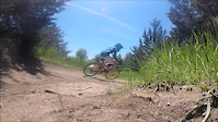
Photos of Omaha Mountain Bike
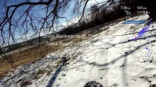
Videos of Omaha Mountain Bike

0:18 |
89 |
Jul 6, 2024
0:26 |
300 |
Jun 20, 2015

53:19 |
331 |
Oct 4, 2020 , Omaha
1:1:41 |
254 |
Oct 4, 2020 , Omaha

54:59 |
480 |
Sep 27, 2020 , Omaha

0:07 |
322 |
Sep 27, 2020 , Omaha

0:09 |
308 |
Sep 27, 2020 , Omaha

0:10 |
346 |
Sep 27, 2020 , Omaha
Current Trail Warnings
| status | trail | date | condition | user | info |
|---|---|---|---|---|---|
| South O' Shredder | Jun 12, 2026 @ 7:14pm (America/Chicago) Jun 12, 2026 | Ideal | fryguy63 THOR | TREE: 6/12 noon Reported on Facebook that... |
Recent Trail Reports
| status | trail | date | condition | info | user |
|---|---|---|---|---|---|
| Hilltop Howl | Jun 15, 2026 @ 7:40pm (America/Chicago) 2 days | Ideal | fryguy63 THOR | ||
| Tranquility Park Cross Country South | Jun 11, 2026 @ 4:17pm (America/Chicago) Jun 11, 2026 | Unknown | nkognito | ||
| Whispering Woods | Jun 10, 2026 @ 12:32pm (America/Chicago) Jun 10, 2026 | Ideal | fryguy63 THOR | ||
| Unity | Jun 10, 2026 @ 12:32pm (America/Chicago) Jun 10, 2026 | Ideal | fryguy63 THOR | ||
| Soul of O | Jun 10, 2026 @ 12:32pm (America/Chicago) Jun 10, 2026 | Ideal | fryguy63 THOR | ||
| Rhythm Roll | Jun 10, 2026 @ 12:32pm (America/Chicago) Jun 10, 2026 | Ideal | fryguy63 THOR | ||
| Purpose Ridge | Jun 10, 2026 @ 12:32pm (America/Chicago) Jun 10, 2026 | Ideal | fryguy63 THOR | ||
| Little Pumphouse | Jun 10, 2026 @ 12:32pm (America/Chicago) Jun 10, 2026 | Ideal | fryguy63 THOR | ||
| Connector North Parking | Jun 10, 2026 @ 12:32pm (America/Chicago) Jun 10, 2026 | Ideal | fryguy63 THOR | ||
| Connector | Jun 10, 2026 @ 12:32pm (America/Chicago) Jun 10, 2026 | Ideal | fryguy63 THOR |
Activity Feed
| username | action | type | title | date |
|---|---|---|---|---|
| Mtbjgo | add | karma | activity #97156417 | Jun 16, 2026 @ 7:16pm 22 hours |
| Dan1MzMLh | comment | report | activity #97154655 | Jun 16, 2026 @ 6:43pm 22 hours |
| fryguy63 | add | report | activity #97077596 | Jun 15, 2026 @ 5:40pm 2 days |
| fryguy63 | like | report | activity #96909005 | Jun 13, 2026 @ 1:02pm Jun 13, 2026 |
| fryguy63 | add | report | activity #96837621 | Jun 12, 2026 @ 5:14pm Jun 12, 2026 |
Recent Comments
| username | type | title | comment | date |
|---|---|---|---|---|
| report | on the downhill stretch heading north after... | Jun 16, 2026 @ 6:43pm 22 hours | ||
| report | Thanks for coming out Wednesday. Great group | May 28, 2026 @ 11:41am May 28, 2026 | ||
| report | Thanks Dan for the post! Are you able to... | May 22, 2026 @ 11:53am May 22, 2026 | ||
| report | Cleared | May 22, 2026 @ 11:48am May 22, 2026 | ||
| report | Cleared | May 22, 2026 @ 11:47am May 22, 2026 |
Local Badges
-

Epic Mountain Bike Climb 2k0 awarded -

Climbing 10k Badge11 awarded -

Mountain Biking 100k Badge1 awarded -

Epic Ride Descent 2k0 awarded -

Descent 10k Badge11 awarded -

Descent 100k Badge1 awarded
Local Mountain Biking Directory
-
Trails Have Our RespectTrail Association
![Trails Have Our Respect]()
-
The Bike WayBike Shop
-
Trek Bicycle Omaha MidtownBike Shop
-
Trek Bicycle of LincolnBike Shop
-
Bike MastersBike Shop
-
Scheels All SportsBike Shop
Activity Type Stats
| activitytype | trails | distance | descent | descent distance | total vertical | rating | global rank | state rank | photos | reports | routes | ridelogs |
|---|---|---|---|---|---|---|---|---|---|---|---|---|
| Mountain Bike | 51 | 22 miles | 1,381 ft | 6 miles | 207 ft | #4,086 | #1,378 | 816 | 709 | 1 | 6,797 | |
| E-Bike | 34 | 4 miles | 164 ft | 4,675 ft | 144 ft | #6,023 | #1,843 | 606 | 1,200 | |||
| Horse | 6 | #2,979 | #1,677 | 48 | ||||||||
| Hike | 62 | 22 miles | 1,381 ft | 6 miles | 207 ft | #5,822 | #2,044 | 713 | 190 | |||
| Trail Running | 63 | 22 miles | 1,381 ft | 6 miles | 207 ft | #3,061 | #893 | 15 | 718 | 67 |
Frequently Asked Questions About Omaha
▼
What are the best places to ride in Omaha?
Omaha has 6 areas to explore for mountain biking. The top rated areas are:
▼
What are the highest rated mountain biking trails in Omaha?
The highest rated mountain biking trails in Omaha are:
- Tranquility Park Cross Country South (4.4/5)
- Little Pumphouse (4.1/5)
- Tranquility Park Cross Country North (4/5)
- Bluebird (4/5)
- La Raza Ridge (4/5)
▼
What is the best time of the year to ride in Omaha?
Based on ride log data, the most popular months to ride in Omaha are:
- June (20 activities)
- July (17 activities)
- August (14 activities)
▼
Where can I park to ride in Omaha?
There are 18 parking locations listed in Omaha. The most popular parking spots are: View all parking and trailhead locations on the map to plan your visit.
Activities
Trails
- By brenthillier
 NSMBA TRAILFORKS & contributors
 - Admins: IGS
- #3607 - 12,671 views
- omaha activity log | embed map of Omaha mountain bike trails | omaha mountain biking points of interest
Downloading of trail gps tracks in kml & gpx formats is enabled for Omaha.
You must login to download files.