close
-
Layers w
- Weather Layers
- Pro
- Pro
- Pro
- Pro
- Pro
- Pro
- More Layers
- Pro
- Pro
- Pro
- Pro
-
Upgrade to

3D
Trail Conditions
- Unknown
- Snow Groomed
- Snow Packed
- Snow Covered
- Snow Cover Partial
- Freeze/thaw Cycle
- Icy
- Prevalent Mud
- Wet
- Variable
- Ideal
- Dry
- Very Dry
Trail Flow (Ridden Direction)
Trailforks scans users ridelogs to determine the most popular direction each trail is ridden. A good flowing trail network will have most trails flowing in a single direction according to their intension.
The colour categories are based on what percentage of riders are riding a trail in its intended direction.
The colour categories are based on what percentage of riders are riding a trail in its intended direction.
- > 96%
- > 90%
- > 80%
- > 70%
- > 50%
- < 50%
- bi-directional trail
- no data
Trail Last Ridden
Trailforks scans ridelogs to determine the last time a trail was ridden.
- < 2 days
- < 1 week
- < 2 weeks
- < 1 month
- < 6 months
- > 6 months
Trail Ridden Direction
The intended direction a trail should be ridden.
- Downhill Only
- Downhill Primary
- Both Directions
- Uphill Primary
- Uphill Only
- One Direction
Contribute Details
Colors indicate trail is missing specified detail.
- Description
- Photos
- Description & Photos
- Videos
Trail Popularity ?
Trailforks scans ridelogs to determine which trails are ridden the most in the last 9 months.
Trails are compared with nearby trails in the same city region with a possible 25 colour shades.
Think of this as a heatmap, more rides = more kinetic energy = warmer colors.
- most popular
- popular
- less popular
- not popular
ATV/ORV/OHV Filter
Max Vehicle Width
inches
US Cell Coverage
Legend

Radar Time
Activity Recordings
Trailforks uses anonymized public activity data.
?
Activity Recordings
Trailforks uses anonymized public activity data.
?
Personal Heatmap
▶
Activity Types
all
/
none
▶
Options
2
Date range
month
–
Winter Trails
Warning
A routing network for winter maps does not exist. Selecting trails using the winter trails layer has been disabled.
Missing Trails
Most Popular
Least Popular
Trails are colored based on popularity. The more popular a trail is, the more red. Less popular trails trend towards green.
Jump Magnitude Heatmap
Heatmap of where riders jump on trails. Zoom in to see individual jumps, click circles to view jump details.
BC Backroad Status
![map legend]()
Service Road Atlas is a free to use, community-driven service for viewing and creating reports on the numerous back-country service roads around B.C. and Alberta.

Slope Aspect
Direction the slope faces
Trails Deemphasized
Trails are shown in grey.
Only show trails with no bike usage.
Suggested Layers
Based on selected activity type
Save the current map location and zoom level as your default home location whenever this page is loaded.
Save
No description for Orderville has been added yet!
Login or register to submit one.
Activities Click to view
- Hike
1 trails
- Mountain Bike
26 trails
- E-Bike
27 trails
- Adaptive Bike
- Winter Fat Bike
0 trails
Region Details
- 11
- 9
- 5
Region Status
Open as of May 27, 2026Stats
- Avg Trail Rating
- Trails (view details)
- 26
- Trails Mountain Bike
- 27
- Trails E-Bike
- 27
- Trails Hike
- 1
- Total Distance
- 26 miles
- Total Descent Distance
- 8 miles
- Total Descent
- 2,600 ft
- Total Vertical
- 1,247 ft
- Highest Trailhead
- 6,830 ft
- Reports
- 215
- Photos
- 92
- Ridden Counter
- 3,641
Sub Regions
-
Applecross MTB Trails
- 12
- 9
- 5
Popular Orderville Mountain Biking Trails
• 90 ★ 4.7 • 2 miles • 404 ft • 299 •
The main spine climbing trail for the upper part of the Applecross Park
• 95 ★ 4.5 • 1 mile • 370 ft • 291 •
Uphill portion of a large remote loop route
• 100 ★ 4.7 • 3 miles • 166 ft • 245 •
The most remote trail in the Applecross System, roaming through the woods to one of the highest points.
• 80 ★ 3.7 • 4,862 ft • 307 ft • 179 •
A more challenging alternative to (hence the name).
• 75 ★ 4.5 • 5,154 ft • 147 ft • 154 •
Green climbing trail for access to downhill trails and other sections of the MTB trail complex
Orderville Mountain Bike Routes
★ 1.0 • 16 miles • 2,424 ft • 11 • Loop •
As of September 2024, this is a route that hits all of the best downhills in the upper section of...
Photos of Orderville Mountain Bike
Videos of Orderville Mountain Bike
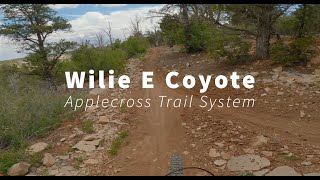
trail: Wile E Coyote
3:57 |
54 |
Aug 4, 2025 , Orderville
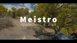
trail: Maestro
4:07 |
108 |
Jul 20, 2025 , Orderville
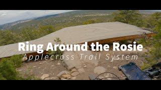
trail: Ring Around the Rosie
8:54 |
94 |
Jul 20, 2025 , Orderville
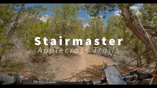
trail: Stair Master
6:48 |
93 |
Jul 20, 2025 , Orderville
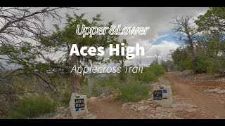
trail: ACEs High (east end)
5:49 |
63 |
Jul 20, 2025 , Orderville

trail: ACEs High (north)
5:49 |
82 |
Jul 20, 2025 , Orderville
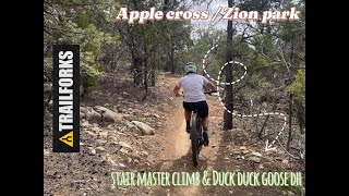
trail: Duck Duck Goose
5:37 |
45 |
May 12, 2025 , Orderville

trail: Stair Master
5:37 |
48 |
May 12, 2025 , Orderville
Recent Trail Reports
Activity Feed
| username | action | type | title | date |
|---|---|---|---|---|
| jschirle4 | wishlist | trail | activity #97675355 and 1 more | Jun 23, 2026 @ 9:58pm 3 days |
| Windowlicker04 | wishlist | region | activity #96652487 | Jun 9, 2026 @ 9:19pm Jun 9, 2026 |
| moosedc | ridden | trail | activity #96559803 | Jun 8, 2026 @ 1:05pm Jun 8, 2026 |
| jonnywachter | wishlist | route | activity #96557420 | Jun 8, 2026 @ 12:26pm Jun 8, 2026 |
| zacmannes | wishlist | trail | activity #96166430 and 1 more | Jun 3, 2026 @ 10:41am Jun 3, 2026 |
Recent Comments
| username | type | title | comment | date |
|---|---|---|---|---|
| trail | Super fun techy descent and climb. Definitely... | May 27, 2026 @ 9:11pm May 27, 2026 | ||
| trail | This is a good climbing trail. Enough techy... | Mar 9, 2026 @ 11:19pm Mar 9, 2026 | ||
| trail | Switchbacks are fun I guess. The trail... | Dec 21, 2025 @ 6:27pm Dec 21, 2025 | ||
| trail | This is a nice trail with good views and fun... | Dec 12, 2025 @ 9:17pm Dec 12, 2025 | ||
| trail | Great flow with a few fun rock obstacles. Well... | Oct 27, 2025 @ 7:41pm Oct 27, 2025 |
Local Badges
-

Completionist0 awarded
Activity Type Stats
| activitytype | trails | distance | descent | descent distance | total vertical | rating | global rank | state rank | photos | reports | routes | ridelogs |
|---|---|---|---|---|---|---|---|---|---|---|---|---|
| Mountain Bike | 26 | 25 miles | 2,589 ft | 8 miles | 823 ft | #3,946 | #1,329 | 95 | 215 | 2 | 766 | |
| E-Bike | 27 | 25 miles | 2,589 ft | 8 miles | 823 ft | #4,528 | #1,459 | 1 | 213 | 1 | 211 | |
| Hike | 1 | 3,635 ft | 13 ft | 417 ft | 295 ft | #15,265 | #5,573 | 1 | 176 | 251 |
Frequently Asked Questions About Orderville
▼
What are the best places to ride in Orderville?
Orderville has 1 areas to explore for mountain biking. The top rated areas are:
▼
What are the highest rated mountain biking trails in Orderville?
The highest rated mountain biking trails in Orderville are:
- Magic Carpet (4.4/5)
- Bison Chute (4.3/5)
- Bison Escape (4.3/5)
- Baby Ridge (4.2/5)
- Ring Around the Rosie (Climb) (4.2/5)
▼
What is the best time of the year to ride in Orderville?
Based on ride log data, the most popular months to ride in Orderville are:
- July (2 activities)
- October (1 activities)
- November (1 activities)
▼
Where can I park to ride in Orderville?
There are 2 parking locations listed in Orderville. The most popular parking spots are:
Trails
Points of Interest
- By bplewe
 TRAILFORKS UVTA & contributors
 - Admins: jkwilliamz, UtahJohn, jpmcghee, jasonmalczyk
- #42585 - 1,026 views
- orderville activity log | embed map of Orderville mountain bike trails | orderville mountain biking points of interest
Downloading of trail gps tracks in kml & gpx formats is enabled for Orderville.
You must login to download files.