close
-
Layers w
- Weather Layers
- Pro
- Pro
- Pro
- Pro
- Pro
- Pro
- More Layers
- Pro
- Pro
- Pro
- Pro
-
Upgrade to

3D
Trail Conditions
- Unknown
- Snow Groomed
- Snow Packed
- Snow Covered
- Snow Cover Partial
- Freeze/thaw Cycle
- Icy
- Prevalent Mud
- Wet
- Variable
- Ideal
- Dry
- Very Dry
Trail Flow (Ridden Direction)
Trailforks scans users ridelogs to determine the most popular direction each trail is ridden. A good flowing trail network will have most trails flowing in a single direction according to their intension.
The colour categories are based on what percentage of riders are riding a trail in its intended direction.
The colour categories are based on what percentage of riders are riding a trail in its intended direction.
- > 96%
- > 90%
- > 80%
- > 70%
- > 50%
- < 50%
- bi-directional trail
- no data
Trail Last Ridden
Trailforks scans ridelogs to determine the last time a trail was ridden.
- < 2 days
- < 1 week
- < 2 weeks
- < 1 month
- < 6 months
- > 6 months
Trail Ridden Direction
The intended direction a trail should be ridden.
- Downhill Only
- Downhill Primary
- Both Directions
- Uphill Primary
- Uphill Only
- One Direction
Contribute Details
Colors indicate trail is missing specified detail.
- Description
- Photos
- Description & Photos
- Videos
Trail Popularity ?
Trailforks scans ridelogs to determine which trails are ridden the most in the last 9 months.
Trails are compared with nearby trails in the same city region with a possible 25 colour shades.
Think of this as a heatmap, more rides = more kinetic energy = warmer colors.
- most popular
- popular
- less popular
- not popular
ATV/ORV/OHV Filter
Max Vehicle Width
inches
US Cell Coverage
Legend

Radar Time
Activity Recordings
Trailforks uses anonymized public activity data.
?
Activity Recordings
Trailforks uses anonymized public activity data.
?
Personal Heatmap
▶
Activity Types
all
/
none
▶
Options
2
Date range
month
–
Winter Trails
Warning
A routing network for winter maps does not exist. Selecting trails using the winter trails layer has been disabled.
Missing Trails
Most Popular
Least Popular
Trails are colored based on popularity. The more popular a trail is, the more red. Less popular trails trend towards green.
Jump Magnitude Heatmap
Heatmap of where riders jump on trails. Zoom in to see individual jumps, click circles to view jump details.
BC Backroad Status
![map legend]()
Service Road Atlas is a free to use, community-driven service for viewing and creating reports on the numerous back-country service roads around B.C. and Alberta.

Slope Aspect
Direction the slope faces
Trails Deemphasized
Trails are shown in grey.
Only show trails with no bike usage.
Suggested Layers
Based on selected activity type
Save the current map location and zoom level as your default home location whenever this page is loaded.
SavePopular Trail Networks
view all areas »
No description for Oro-Medonte has been added yet!
Login or register to submit one.
Activities Click to view
- Mountain Bike
655 trails
- E-Bike
255 trails
- Gravel Bike
1 trails
- Adaptive Bike
1 trails
- Winter Fat Bike
3 trails
- Horse
351 trails
- Hike
630 trails
- Trail Running
628 trails
- Dirtbike/Moto
118 trails
- ATV/ORV/OHV
46 trails
- Snowmobile
131 trails
- Snowshoe
433 trails
- Downhill Ski
129 trails
- Backcountry Ski
6 trails
- Nordic Ski
311 trails
Region Details
- 269
- 1
- 159
- 147
- 67
- 9
Region Status
Caution as of 7 hoursStats
- Avg Trail Rating
- Trails (view details)
- 827
- Trails Mountain Bike
- 655
- Trails E-Bike
- 255
- Trails Gravel Bike
- 1
- Trails Adaptive Bike
- 1
- Trails Winter Fat Bike
- 3
- Trails Horse
- 351
- Trails Hike
- 630
- Trails Trail Running
- 628
- Trails Dirtbike/Moto
- 118
- Trails ATV/ORV/OHV
- 46
- Trails Snowmobile
- 131
- Trails Snowshoe
- 433
- Trails Downhill Ski
- 129
- Trails Backcountry Ski
- 6
- Trails Nordic Ski
- 311
- Total Distance
- 344 miles
- Total Descent
- 39,362 ft
- Total Vertical
- 617 ft
- Highest Trailhead
- 1,327 ft
- Reports
- 8,359
- Photos
- 696
- Ridden Counter
- 204,824
Articles
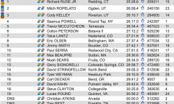
Results: Canadian National Championships 2019
Jul 28, 2019 from pinkbike.com
Check out all the results from the 2019 Canadian National Championships.
Sub Regions
-
Copeland Forest
- 57
- 29
- 13
-
East Coulson Swamp Reserve
-
Hardwood Ski and Bike
- 26
- 54
- 46
- 4
-
Horseshoe Valley Bike Park
- 7
- 7
- 4
- 3
-
Oro Hills
- 4
-
SCMBC - Amos Tract Trail Network
- 1
- 1
-
SCMBC - Heights of Horseshoe
- 3
- 1
- 5
- 2
-
SCMBC - ORO Trail Network
- 13
- 40
-
Simcoe County Forest - Amos Tract
- 2
- 2
-
Simcoe County Forest - Arbour Tract
- 1
-
Simcoe County Forest - Barton Tract
-
Simcoe County Forest - Boys Tract
- 2
-
Simcoe County Forest - Breedon Tract
- 2
-
Simcoe County Forest - Centennial Tract
-
Simcoe County Forest - Crawford Tract
- 1
- 1
-
Simcoe County Forest - Douglas Tract
-
Simcoe County Forest - Drury Main Tract
- 9
-
Simcoe County Forest - Elsie Mills Tract
-
Simcoe County Forest - Hutchison/Brown Tract
-
Simcoe County Forest - Johnson Tract
-
Simcoe County Forest - Marrin Tract
-
Simcoe County Forest - North Barr Tract
- 2
- 9
-
Simcoe County Forest - Oro Tract
-
Simcoe County Forest - Schumacher Tract
- 3
-
Simcoe County Forest - South Barr Tract
- 3
-
Simcoe County Forest - Strachan Tract
- 3
-
Simcoe County Forest - Sutherland Tract
- 1
-
Simcoe County Forest - Tustin Tract
- 2
-
The Heights Ski & Country Club
- 4
- 1
Popular Oro-Medonte Mountain Biking Trails
• 95 ★ 4.6 • 1,699 ft • 0 ft • 1,404 •
Flow trail with a few small rooty sections, lots of small/medium jumps, and more berms than you can shake a stick at. One of the original Horseshoe DH trails, located by the southernmost triple chair.
• 90 ★ 3.5 • 1,532 ft • 0 ft • 1,310 •
Mild smooth downhill trail with small berms and descents to practice on.
• 100 ★ 3.5 • 988 ft • 0 ft • 1,236 •
Popular green difficulty family friendly singletrack. This mountain bike primary trail can be used downhill only and has a easy overall physical rating with a 0 ft green climb. Trail visibility is always easy to follow. On average it takes minutes to complete this trail.
• 100 ★ 4.5 • 4 miles • 286 ft • 1,213 •
Highly rated popular blue difficulty singletrack. This mountain bike primary trail can be used downhill primary and has a moderate overall physical rating with a 286 ft blue climb. Trail visibility is always easy to follow. On average it takes 27 minutes to complete this trail.
• 100 ★ 0.0 • 719 ft • 0 ft • 1,209 •
Popular green difficulty singletrack. This multi-use trail can be used both directions and has a easy overall physical rating with a 0 ft green climb. On average it takes minutes to complete this trail.
• 80 ★ 4.3 • 1,909 ft • 0 ft • 1,204 •
One of the HSBP favourites, fast and flowy machine made trail. If your significant other won't show you support, these berms certainly will. Ideal trail for anyone looking to go fast, or take it easy. It's a great "One Size Fits All"...
• 100 ★ 4.0 • 2,766 ft • 187 ft • 1,190 •
is primarily used to climb up to the "5 Points" ridge top. The climb is a tough one, with tight turns, punchy climbs and littered with roots. It will get the blood flowing.
• 100 ★ 3.8 • 1,404 ft • 13 ft • 1,170 •
A trail primarily used to access the DH trails at the other end.
Oro-Medonte Mountain Bike Routes
Fun Course Featured
★ 5.0 • 3 miles • 199 ft • 5 • Loop •
An easy beginner course. Starts with slow climb to high point on double track. Easy single track and ends...
SCMBC Oro FatBike 2025 Featured
★ 5.0 • 14 miles • 982 ft • 10 • Loop •
SCMBC Oro fat bike route for 2025
★ 3.5 • 7 miles • 890 ft • 16 • Loop •
Hope you enjoy this great tour of the Copeland Forest! Starts and ends at the parking lot north of...
★ 5.0 • 5 miles • 269 ft • 12 • Loop •
Easy to moderate ride. Starts with long double track climb and finishes with nice downhill run.
★ 3.5 • 6 miles • 390 ft • 9 • Loop •
11km moderately physically and technically challenging course
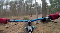
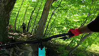
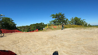
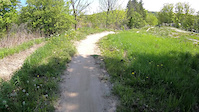
Photos of Oro-Medonte Mountain Bike
Videos of Oro-Medonte Mountain Bike
featured
![Copeland - April 16th, 2017]()
trail: Copeland Downhill
4:14 |
907 |
Apr 16, 2017

trail: Shake N' Brake
0:54 |
60 |
Aug 17, 2025
trail: Smith's Thriller
2:14 |
33 |
Sep 4, 2024
trail: Dark Roast
0:32 |
|
Sep 2, 2024
trail: Horseshoe O-Cup XC Trail
0:23 |
241 |
May 8, 2024

trail: Despicable Me
4:12 |
32 |
Nov 17, 2023
trail: Party Train
0:41 |
106 |
Aug 3, 2023

trail: Smith's Thriller
0:35 |
63 |
Nov 12, 2022
Current Trail Warnings
| status | trail | date | condition | user | info |
|---|---|---|---|---|---|
| Double Track - Sign Post 4 to 5 | Jun 20, 2026 @ 12:03pm (America/Vancouver) 2 days | Unknown | trailforks Trailforks | ||
| Singletrack Trail | Jun 11, 2026 @ 9:28am (America/Toronto) Jun 11, 2026 | Unknown | Canadmos TRAILFORKS | Still blocked with trees.. | |
| Ganaraska Trail | Jun 11, 2026 @ 9:25am (America/Toronto) Jun 11, 2026 | Ideal | Canadmos TRAILFORKS | Trail appears to be blocked with trees. |
Recent Trail Reports
Activity Feed
| username | action | type | title | date |
|---|---|---|---|---|
| Canadmos | add | report | activity #97537616 | Jun 21, 2026 @ 6:56pm 7 hours |
| Canadmos | add | report | activity #97537596 | Jun 21, 2026 @ 6:56pm 7 hours |
| Canadmos | add | report | activity #97537333 and 1 more | Jun 21, 2026 @ 6:49pm 7 hours |
| bcintor | add | report | activity #97516688 and 3 more | Jun 21, 2026 @ 1:35pm 13 hours |
| TCxXLu | add | karma | activity #97479590 | Jun 21, 2026 @ 6:47am 19 hours |
Recent Comments
| username | type | title | comment | date |
|---|---|---|---|---|
| report | Totally not passable overgrown with fallen... | Jun 20, 2026 @ 7:23am 2 days | ||
| report | AMEN | Jun 1, 2026 @ 3:07pm Jun 1, 2026 | ||
| trail | Someone cut the easy log ride over the creek... | May 20, 2026 @ 7:48pm May 20, 2026 | ||
| report | I bushwacked through a part and it was truly... | Nov 1, 2025 @ 11:10am Nov 1, 2025 | ||
| report | Some are, but many areas have been reopened.... | Oct 30, 2025 @ 8:21am Oct 30, 2025 |
Local Badges
-

Horseshoe Single Ride Thriller v218 awarded -

Horseshoe Completionist380 awarded -

Big Ride 30k4,399 awarded -

Epic Ride 50k1,155 awarded -

Top 10 Trails120 awarded -

Completionist3 awarded
Bike & Skill Parks
| name | type | city | rating |
|---|---|---|---|
| Horseshoe Valley Bike Park | bike park | Oro-Medonte |
Activity Type Stats
| activitytype | trails | distance | descent | descent distance | total vertical | rating | global rank | state rank | photos | reports | routes | ridelogs |
|---|---|---|---|---|---|---|---|---|---|---|---|---|
| Mountain Bike | 655 | 274 miles | 23,976 ft | 103 miles | 607 ft | #41 | #3 | 629 | 8,261 | 44 | 65,085 | |
| E-Bike | 255 | 114 miles | 10,489 ft | 40 miles | 554 ft | #447 | #36 | 15 | 5,089 | 3 | 1,335 | |
| Gravel Bike | 1 | #379 | #46 | 46 | 121 | |||||||
| Adaptive Bike | 1 | #296 | #76 | 3 | 2 | |||||||
| Winter Fat Bike | 3 | #222 | #70 | 2 | 29 | 3 | 19 | |||||
| Horse | 351 | 145 miles | 11,512 ft | 51 miles | 594 ft | #76 | #11 | 1,273 | 102 | |||
| Hike | 630 | 274 miles | 21,457 ft | 101 miles | 607 ft | #222 | #2 | 35 | 7,814 | 8 | 4,760 | |
| Trail Running | 628 | 272 miles | 21,375 ft | 100 miles | 607 ft | #120 | #2 | 2 | 8,016 | 8 | 2,892 | |
| Dirtbike/Moto | 118 | 67 miles | 4,022 ft | 24 miles | 531 ft | #214 | #3 | 1 | 510 | 53 | ||
| ATV/ORV/OHV | 46 | 24 miles | 1,224 ft | 9 miles | 531 ft | #419 | #4 | 3 | 473 | 18 | ||
| Snowmobile | 131 | 52 miles | 3,022 ft | 20 miles | 561 ft | #62 | #3 | 157 | 5 | |||
| Snowshoe | 433 | 224 miles | 17,037 ft | 84 miles | 607 ft | #13 | #3 | 2 | 2,379 | 9 | 773 | |
| Downhill Ski | 129 | 19 miles | 10,984 ft | 16 miles | 600 ft | #60 | #2 | 7 | 96 | 3,437 | ||
| Backcountry Ski | 6 | 4,337 ft | 118 ft | 2,493 ft | 131 ft | #450 | #8 | 113 | 2 | 119 | ||
| Nordic Ski | 311 | 169 miles | 10,689 ft | 62 miles | 607 ft | #32 | #2 | 1 | 1,614 | 9 | 3,514 |
Frequently Asked Questions About Oro-Medonte
▼
What are the best places to ride in Oro-Medonte?
Oro-Medonte has 32 areas to explore for mountain biking. The top rated areas are:
▼
What are the highest rated mountain biking trails in Oro-Medonte?
The highest rated mountain biking trails in Oro-Medonte are:
- Copeland Downhill (4.6/5)
- Smith's Thriller (4.6/5)
- Party Train (4.5/5)
- 5th Dimension (4.5/5)
- Amos Tract Red (4.5/5)
▼
What is the best time of the year to ride in Oro-Medonte?
Based on ride log data, the most popular months to ride in Oro-Medonte are:
- July (1,664 activities)
- June (1,469 activities)
- May (1,321 activities)
▼
Where can I park to ride in Oro-Medonte?
There are 31 parking locations listed in Oro-Medonte. The most popular parking spots are:
- Parking - SCMBC Trail head
- Copeland Forest Trailhead - Horseshoe Nordic Center
- Parking - 100 Bass Lake Sideroad
- P4 Parking
- Strachan North Parking
Activities
- Oro-Medonte Mountain Biking Trails
- Oro-Medonte E-Biking Trails
- Oro-Medonte Horseback Trails
- Oro-Medonte Hiking Trails
- Oro-Medonte Trail Running Trails
- Oro-Medonte Dirtbiking Trails
- Oro-Medonte ATVing/Offroading Trails
- Oro-Medonte Snowmobiling Trails
- Oro-Medonte Snowshoeing Trails
- Oro-Medonte Skiing Trails
- Oro-Medonte Backcountry Skiing Trails
- Oro-Medonte Nordic Skiing Trails
Trails
- By brenthillier
 NSMBA TRAILFORKS & contributors
 - Admins: apply
- #5637 - 22,335 views
- oro-medonte activity log | embed map of Oro-Medonte mountain bike trails | oro-medonte mountain biking points of interest polygons
Downloading of trail gps tracks in kml & gpx formats is enabled for Oro-Medonte.
You must login to download files.