close
-
Layers w
- Weather Layers
- Pro
- Pro
- Pro
- Pro
- Pro
- Pro
- More Layers
- Pro
- Pro
- Pro
- Pro
-
Upgrade to

3D
Trail Conditions
- Unknown
- Snow Groomed
- Snow Packed
- Snow Covered
- Snow Cover Partial
- Freeze/thaw Cycle
- Icy
- Prevalent Mud
- Wet
- Variable
- Ideal
- Dry
- Very Dry
Trail Flow (Ridden Direction)
Trailforks scans users ridelogs to determine the most popular direction each trail is ridden. A good flowing trail network will have most trails flowing in a single direction according to their intension.
The colour categories are based on what percentage of riders are riding a trail in its intended direction.
The colour categories are based on what percentage of riders are riding a trail in its intended direction.
- > 96%
- > 90%
- > 80%
- > 70%
- > 50%
- < 50%
- bi-directional trail
- no data
Trail Last Ridden
Trailforks scans ridelogs to determine the last time a trail was ridden.
- < 2 days
- < 1 week
- < 2 weeks
- < 1 month
- < 6 months
- > 6 months
Trail Ridden Direction
The intended direction a trail should be ridden.
- Downhill Only
- Downhill Primary
- Both Directions
- Uphill Primary
- Uphill Only
- One Direction
Contribute Details
Colors indicate trail is missing specified detail.
- Description
- Photos
- Description & Photos
- Videos
Trail Popularity ?
Trailforks scans ridelogs to determine which trails are ridden the most in the last 9 months.
Trails are compared with nearby trails in the same city region with a possible 25 colour shades.
Think of this as a heatmap, more rides = more kinetic energy = warmer colors.
- most popular
- popular
- less popular
- not popular
ATV/ORV/OHV Filter
Max Vehicle Width
inches
US Cell Coverage
Legend

Radar Time
Activity Recordings
Trailforks uses anonymized public activity data.
?
Activity Recordings
Trailforks uses anonymized public activity data.
?
Personal Heatmap
▶
Activity Types
all
/
none
▶
Options
2
Date range
month
–
Winter Trails
Warning
A routing network for winter maps does not exist. Selecting trails using the winter trails layer has been disabled.
Missing Trails
Most Popular
Least Popular
Trails are colored based on popularity. The more popular a trail is, the more red. Less popular trails trend towards green.
Jump Magnitude Heatmap
Heatmap of where riders jump on trails. Zoom in to see individual jumps, click circles to view jump details.
BC Backroad Status
![map legend]()
Service Road Atlas is a free to use, community-driven service for viewing and creating reports on the numerous back-country service roads around B.C. and Alberta.

Slope Aspect
Direction the slope faces
Trails Deemphasized
Trails are shown in grey.
Only show trails with no bike usage.
Suggested Layers
Based on selected activity type
Save the current map location and zoom level as your default home location whenever this page is loaded.
Save
No description for Ottawa has been added yet!
Login or register to submit one.
Activities Click to view
- Mountain Bike
155 trails
- E-Bike
73 trails
- Adaptive Bike
0 trails
- Winter Fat Bike
0 trails
- Hike
176 trails
- Trail Running
176 trails
- Snowshoe
35 trails
- Nordic Ski
29 trails
Region Details
- 85
- 27
- 19
- 13
- 2
Region Status
Open as of Jun 15, 2026Stats
- Avg Trail Rating
- Trails (view details)
- 150
- Trails Mountain Bike
- 155
- Trails E-Bike
- 73
- Trails Hike
- 176
- Trails Trail Running
- 176
- Trails Snowshoe
- 35
- Trails Backcountry Ski
- 1
- Trails Nordic Ski
- 29
- Total Distance
- 54 miles
- Total Descent
- 1,463 ft
- Total Vertical
- 251 ft
- Highest Trailhead
- 402 ft
- Reports
- 909
- Photos
- 66
- Ridden Counter
- 13,579
Articles
Video: Jeremy Menduni's Summer of Shredding in Ottawa
Oct 22, 2019 from pinkbike.com
From urban tech to bike park hits, Jeremy Menduni shows off the best that Ottawa has to offer.
Sub Regions
-
Central Experimental Farm
- 11
-
Hog's Back Park
- 2
-
Kichi Sibi Winter Trail
- 13
- 5
-
Monaghan Forest Park
- 2
-
Ottawa/Rideau River Trail System
- 4
-
Shirleys Bay
- 7
- 1
- 3
Popular Ottawa Mountain Biking Trails
• 100 ★ 3.5 • 4,711 ft • 11 ft • 358 •
Popular white difficulty paved path. This mountain bike primary trail can be used both directions. On average it takes 3 minutes to complete this trail.
• 5 ★ 0.0 • 3 miles • 32 ft • 193 • • skixc
Less popular green difficulty family friendly machine groomed. This nordic ski primary trail can be used both directions and has a easy overall physical rating with a 32 ft green climb. Winter use: Classic / Skating snow grooming. Trail visibility is always easy to follow. On average it takes 15 minutes to complete this trail.
• 85 ★ 2.0 • 1 mile • 7 ft • 147 •
Popular white difficulty gravel path. This mountain bike primary trail can be used both directions. On average it takes 7 minutes to complete this trail.
• 70 ★ 3.0 • 909 ft • 2 ft • 144 •
Popular blue difficulty singletrack. This mountain bike primary trail can be used both directions. On average it takes minutes to complete this trail.
• 60 ★ 1.5 • 3,035 ft • 15 ft • 141 •
Access from NCC P3 off of Corkstown W of Moodie, E of March. Single track with a few wooden bridges and a steep rocky bit near the end. Collects water/mud in places. This trail in winter connects with Kanata Nordic trail system (Trail...
• 95 ★ 3.0 • 2 miles • 20 ft • 135 •
Popular white difficulty doubletrack. This multi-use trail can be used both directions and has a easy overall physical rating with a 20 ft green climb. Trail visibility is always easy to follow.
• 85 ★ 2.0 • 1,932 ft • 11 ft • 129 •
Popular white difficulty paved path. This mountain bike primary trail can be used both directions. On average it takes 9 minutes to complete this trail.
• 80 ★ 2.0 • 2,290 ft • 22 ft • 121 •
Popular white difficulty gravel path. This mountain bike primary trail can be used both directions. On average it takes 5 minutes to complete this trail.
Ottawa Mountain Bike Routes
6 miles • 211 ft • 7 •
This is a short version of the classic outback where we skip PWT
6 miles • 144 ft • 11 • Loop •
Route hitting the more popular/higher rated trails in the directions that gets the most downhill within...
8 miles • 230 ft • 24 • Loop •
A medium length loop using PWT and Outback. Has some difficulty sections but is a great loop for even blue...
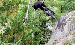
Photos of Ottawa Mountain Bike
Recent Trail Reports
Activity Feed
| username | action | type | title | date |
|---|---|---|---|---|
| Cardinal1010 | add | report | activity #97109294 and 1 more | Jun 16, 2026 @ 7:37am 2 days |
| Sauljea | add | report | activity #97070594 and 4 more | Jun 15, 2026 @ 3:54pm 3 days |
| Sauljea | vote | trail | activity #97056207 | Jun 15, 2026 @ 11:42am 3 days |
| Sauljea | vote | trail | activity #97055976 | Jun 15, 2026 @ 11:39am 3 days |
| Sauljea | add | report | activity #96727915 and 4 more | Jun 11, 2026 @ 4:15am Jun 11, 2026 |
Recent Comments
| username | type | title | comment | date |
|---|---|---|---|---|
| trail | This is overgrown as of 2025 | Apr 28, 2025 @ 11:01am Apr 28, 2025 | ||
| trail | LOL. Yeah I named it something that represents... | Apr 5, 2024 @ 4:07pm Apr 5, 2024 | ||
| trail | Oh...well duh hah I though it was the name of... | Apr 5, 2024 @ 3:28pm Apr 5, 2024 | ||
| trail | Train à Grande Vitesse High Speed Train | Apr 5, 2024 @ 2:47pm Apr 5, 2024 | ||
| trail | What does TGV stand for? | Apr 5, 2024 @ 2:03pm Apr 5, 2024 |
Local Badges
-

10 Green Trails53 awarded -

Epic Ride Climb 2k4 awarded -

Climbing 10k Badge71 awarded -

Climbing 100k Badge1 awarded -

Epic Ride Descent 2k4 awarded -

Descent 10k Badge70 awarded
Bike & Skill Parks
| name | type | city | rating |
|---|---|---|---|
| Carlington Bike Park | skill park | Ottawa | |
| Lansdowne (Street/BMX) Park | skill park | Ottawa | |
| Canadian Supreme Court | skill park | Ottawa |
Activity Type Stats
| activitytype | trails | distance | descent | descent distance | total vertical | rating | global rank | state rank | photos | reports | routes | ridelogs |
|---|---|---|---|---|---|---|---|---|---|---|---|---|
| Mountain Bike | 155 | 53 miles | 1,434 ft | 18 miles | 253 ft | #1,483 | #35 | 66 | 896 | 5 | 46,156 | |
| E-Bike | 73 | 9 miles | 177 ft | 3 miles | 69 ft | #2,766 | #52 | 838 | 972 | |||
| Hike | 176 | 53 miles | 1,434 ft | 18 miles | 253 ft | #1,938 | #46 | 895 | 1 | 1,060 | ||
| Trail Running | 176 | 53 miles | 1,434 ft | 18 miles | 253 ft | #1,126 | #22 | 895 | 7,600 | |||
| Snowshoe | 35 | 16 miles | 410 ft | 5 miles | 144 ft | #423 | #43 | 28 | 81 | |||
| Backcountry Ski | 1 | 13 | 12 | |||||||||
| Nordic Ski | 29 | 10 miles | 223 ft | 3 miles | 144 ft | #380 | #16 | 24 | 1,571 |
Frequently Asked Questions About Ottawa
▼
What are the best places to ride in Ottawa?
Ottawa has 7 areas to explore for mountain biking. The top rated areas are:
▼
What are the highest rated mountain biking trails in Ottawa?
The highest rated mountain biking trails in Ottawa are:
- ITW (4.1/5)
- Ottawa River Pathway (4/5)
- Corks to Watts (3.9/5)
- The Gord Downie (3.9/5)
- Lock Connector (3.8/5)
▼
What is the best time of the year to ride in Ottawa?
Based on ride log data, the most popular months to ride in Ottawa are:
- July (174 activities)
- August (118 activities)
- May (105 activities)
▼
Where can I park to ride in Ottawa?
Activities
Trails
- By sandodcmando
 & contributors
 - Admins: OMBA, Br1ngiton
- #7708 - 45,854 views
- ottawa activity log | embed map of Ottawa mountain bike trails | ottawa mountain biking points of interest
Downloading of trail gps tracks in kml & gpx formats is enabled for Ottawa.
You must login to download files.