close
-
Layers w
- Weather Layers
- Pro
- Pro
- Pro
- Pro
- Pro
- Pro
- More Layers
- Pro
- Pro
- Pro
- Pro
-
Upgrade to

3D
Trail Conditions
- Unknown
- Snow Groomed
- Snow Packed
- Snow Covered
- Snow Cover Partial
- Freeze/thaw Cycle
- Icy
- Prevalent Mud
- Wet
- Variable
- Ideal
- Dry
- Very Dry
Trail Flow (Ridden Direction)
Trailforks scans users ridelogs to determine the most popular direction each trail is ridden. A good flowing trail network will have most trails flowing in a single direction according to their intension.
The colour categories are based on what percentage of riders are riding a trail in its intended direction.
The colour categories are based on what percentage of riders are riding a trail in its intended direction.
- > 96%
- > 90%
- > 80%
- > 70%
- > 50%
- < 50%
- bi-directional trail
- no data
Trail Last Ridden
Trailforks scans ridelogs to determine the last time a trail was ridden.
- < 2 days
- < 1 week
- < 2 weeks
- < 1 month
- < 6 months
- > 6 months
Trail Ridden Direction
The intended direction a trail should be ridden.
- Downhill Only
- Downhill Primary
- Both Directions
- Uphill Primary
- Uphill Only
- One Direction
Contribute Details
Colors indicate trail is missing specified detail.
- Description
- Photos
- Description & Photos
- Videos
Trail Popularity ?
Trailforks scans ridelogs to determine which trails are ridden the most in the last 9 months.
Trails are compared with nearby trails in the same city region with a possible 25 colour shades.
Think of this as a heatmap, more rides = more kinetic energy = warmer colors.
- most popular
- popular
- less popular
- not popular
ATV/ORV/OHV Filter
Max Vehicle Width
inches
US Cell Coverage
Legend

Radar Time
Activity Recordings
Trailforks uses anonymized public activity data.
?
Activity Recordings
Trailforks uses anonymized public activity data.
?
Personal Heatmap
▶
Activity Types
all
/
none
▶
Options
2
Date range
month
–
Winter Trails
Warning
A routing network for winter maps does not exist. Selecting trails using the winter trails layer has been disabled.
Missing Trails
Most Popular
Least Popular
Trails are colored based on popularity. The more popular a trail is, the more red. Less popular trails trend towards green.
Jump Magnitude Heatmap
Heatmap of where riders jump on trails. Zoom in to see individual jumps, click circles to view jump details.
BC Backroad Status
![map legend]()
Service Road Atlas is a free to use, community-driven service for viewing and creating reports on the numerous back-country service roads around B.C. and Alberta.

Slope Aspect
Direction the slope faces
Trails Deemphasized
Trails are shown in grey.
Only show trails with no bike usage.
Suggested Layers
Based on selected activity type
Save the current map location and zoom level as your default home location whenever this page is loaded.
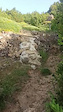
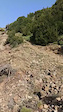
SaveMonte con muchas posibilidades por ambas caras, de conglomerado con lo que las sendas son casi todo de firme o rocoso o descompuesto de cantos rodados, accesos por pistas en buenas condiciones, eso si, largassssss
Primary Trail Type: All-Mountain & Downhill
eBikes Allowed:
Yes
This region uses the Uk/Euro style trail grading system.
Activities Click to view
- Mountain Bike
74 trails
- E-Bike
74 trails
- Horse
10 trails
- Hike
77 trails
- Trail Running
77 trails
Region Details
- 22
- 1
- 28
- 12
- 2
Region Status
Caution as of Jun 14, 2026Stats
- Avg Trail Rating
- Trails (view details)
- 68
- Trails Mountain Bike
- 74
- Trails E-Bike
- 74
- Trails Horse
- 10
- Trails Hike
- 77
- Trails Trail Running
- 77
- Total Distance
- 79 miles
- Total Descent Distance
- 38 miles
- Total Descent
- 21,700 ft
- Total Vertical
- 3,711 ft
- Highest Trailhead
- 6,253 ft
- Reports
- 180
- Photos
- 210
- Ridden Counter
- 930
Popular Oturia Mountain Biking Trails
• 100 ★ 3.5 • 561 ft • 0 ft • 46 •
Popular blue difficulty wilderness trail. This multi-use trail can be used both directions. Trail visibility is always easy to follow. On average it takes 1 minutes to complete this trail.
• 90 ★ 4.0 • 1 mile • 9 ft • 46 •
Popular blue difficulty family friendly singletrack. This multi-use trail can be used downhill primary. It features drop and log ride. Trail visibility is always easy to follow. On average it takes 15 minutes to complete this trail.
• 95 ★ 4.0 • 1,539 ft • 16 ft • 43 •
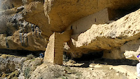
Sendero que podria ser verde, salvo por al anchura, tiene en un lateral una pequeña acequia y manguera de agua, y al otro lado caida lateral. sombrio por bosque, muy chulo y sencillo
• 90 ★ 4.0 • 4,596 ft • 72 ft • 42 •
Sendero muy flow, divertido, Azul inferior, tramo superior que recorre zona de margas. Evitar epocas de lluvias debido al barro. cruce de barranco y pequeño tramo de empuja bike
• 85 ★ 2.5 • 3,901 ft • 49 ft • 34 •
De subida, osea en sentido contrario al propuesto, tiene un tramo de fuerte pendiente, curvas y escalones que pocos podrán subir montados, en sentido propuesto divertido, con subida suave y la bajada nombrada, como punto más complicado.
• 95 ★ 0.0 • 1,444 ft • 106 ft • 34 •
Popular blue difficulty singletrack. This multi-use trail can be used downhill primary and has a hard overall physical rating with a 106 ft black diamond climb. Trail visibility is always easy to follow. On average it takes 2 minutes to complete this trail.
• 80 ★ 4.0 • 1,801 ft • 0 ft • 28 •
Popular blue difficulty wilderness trail. This multi-use trail can be used both directions and has a moderate overall physical rating with a 0 ft blue climb. Trail visibility is always easy to follow. On average it takes 14 minutes to complete this trail.
• 70 ★ 4.0 • 3,606 ft • 32 ft • 26 •
Unica dificultad, la salida al cruce del barranco dirección Olivan!!
Oturia Mountain Bike Routes
22 miles • 3,591 ft • 2 • Loop •
Salimos del casco urbano de Senegüé por una pista en dirección este, cruzamos el río Gállego a...
21 miles • 3,807 ft • 4 • Point to Point •
Ruta lineal que parte de la localidad de Yebra de Basa para terminar en Biescas. El recorrido se inicia...
34 miles • 5,475 ft • 3 • Loop •
Ruta que, por su desnivel y kilómetros, exige muy buen nivel físico y técnico. Parte de Yebra de Basa y...
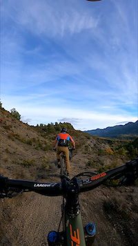
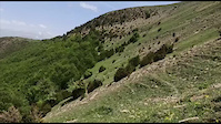
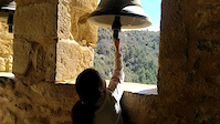
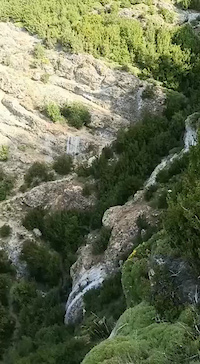
Photos of Oturia Mountain Bike
Videos of Oturia Mountain Bike
0:28 |
21 |
Nov 14, 2023
trail: Bajoturia
0:26 |
14 |
May 28, 2023
trail: De las Ermitas de Yebra
0:07 |
20 |
Mar 24, 2023
trail: San Román De Basa
0:17 |
48 |
Jun 19, 2022
trail: San Román De Basa
0:05 |
42 |
Jun 19, 2022
trail: San Román De Basa
0:16 |
33 |
Jun 19, 2022
trail: De las Ermitas de Yebra
0:15 |
28 |
Mar 24, 2023
trail: Corona Santa Cilia
38 |
Jun 6, 2025 , Sabiñánigo
Recent Trail Reports
| status | trail | date | condition | info | user |
|---|---|---|---|---|---|
| Torre del Moro | Jun 14, 2026 @ 3:02pm (Europe/Madrid) Jun 14, 2026 | Dry | Lucasmtb2 | ||
| Bosque Las Lienas | Jun 8, 2026 @ 12:04pm (Europe/Madrid) Jun 8, 2026 | Ideal | Lucasmtb2 | ||
| O Puerto Javierre | May 30, 2026 @ 2:34pm (Europe/Madrid) May 30, 2026 | Ideal | Lucasmtb2 | ||
| Barranco de las Gargantas | May 30, 2026 @ 2:33pm (Europe/Madrid) May 30, 2026 | Ideal | Lucasmtb2 | ||
| Arista Ermita de la Santa Cruz | Apr 20, 2026 @ 10:46pm (Europe/Madrid) Apr 20, 2026 | Variable | MiguelyH6rqv | ||
| Enlace Santa Orosia | Apr 14, 2026 @ 11:30pm (Europe/Madrid) Apr 14, 2026 | Ideal | MiguelyH6rqv | ||
| San Román De Basa | Apr 14, 2026 @ 11:29pm (Europe/Madrid) Apr 14, 2026 | Dry | MiguelyH6rqv | ||
| Punta del Mallo por Canales | Apr 1, 2026 @ 8:29pm (Europe/Madrid) Apr 1, 2026 | Dry | lBFUej | ||
| Barranco de la Fuente | Apr 1, 2026 @ 6:14pm (Europe/Madrid) Apr 1, 2026 | Unknown | lBFUej | ||
| Satué-Isún De Basa Intermedio | Apr 1, 2026 @ 1:37pm (Europe/Madrid) Apr 1, 2026 | Ideal | lBFUej |
Activity Feed
| username | action | type | title | date |
|---|---|---|---|---|
| Lucasmtb2 | add | report | activity #96960189 | Jun 14, 2026 @ 6:02am Jun 14, 2026 |
| Lucasmtb2 | add | report | activity #96527912 and 2 more | Jun 8, 2026 @ 3:00am Jun 8, 2026 |
| Lucasmtb2 | add | report | activity #95841666 and 2 more | May 30, 2026 @ 5:33am May 30, 2026 |
| Angelreing | add | trail | activity #94576329 | May 12, 2026 @ 12:10pm May 12, 2026 |
| Grosso | add | trail | activity #94567236 and 1 more | May 12, 2026 @ 10:07am May 12, 2026 |
Recent Comments
| username | type | title | comment | date |
|---|---|---|---|---|
| trail | He hecho esta bajada unas 10 veces mínimo, no... | Mar 31, 2026 @ 12:50pm Mar 31, 2026 | ||
| trail | Mola. | Mar 31, 2026 @ 12:35pm Mar 31, 2026 | ||
| trail | Hace dos años y medio lo intenté ciclar y me... | Mar 31, 2026 @ 12:34pm Mar 31, 2026 | ||
| trail | El terreno con mucho grip, lo único que en... | Mar 21, 2026 @ 3:43pm Mar 21, 2026 | ||
| report | 100% de acuerdo! | Feb 7, 2026 @ 8:38am Feb 7, 2026 |
Nearby Areas
| name | distance | ||||
|---|---|---|---|---|---|
| Zona Zerdo | 7 | 5 km | |||
| Gavín | 3 | 23 | 6.3 km | ||
| Jarlata | 10 | 8.2 km | |||
| Zona Zero Rio Ara | 2 | 38 | 8.3 km | ||
| Sobremonte | 5 | 21 | 8.4 km |
Local Badges
-

Completionist0 awarded
Activity Type Stats
| activitytype | trails | distance | descent | descent distance | total vertical | rating | global rank | state rank | photos | reports | routes | ridelogs |
|---|---|---|---|---|---|---|---|---|---|---|---|---|
| Mountain Bike | 74 | 74 miles | 18,245 ft | 34 miles | 3,658 ft | #3,946 | #308 | 202 | 179 | 3 | 244 | |
| E-Bike | 74 | 74 miles | 18,245 ft | 34 miles | 3,658 ft | #1,993 | #408 | 8 | 165 | 3 | 64 | |
| Horse | 10 | #3,316 | #299 | 6 | ||||||||
| Hike | 77 | 79 miles | 21,699 ft | 38 miles | 3,711 ft | #2,817 | #317 | 180 | 16 | |||
| Trail Running | 77 | 79 miles | 21,699 ft | 38 miles | 3,711 ft | #2,130 | #293 | 177 | 27 |
Frequently Asked Questions About Oturia
▼
What are the highest rated mountain biking trails in Oturia?
The highest rated mountain biking trails in Oturia are:
- San Román De Basa (4.2/5)
- San Roman-Yebra de Basa Superior (4.1/5)
- Barranco de Tramafoz (4.1/5)
- Pardina De Busa (4.1/5)
- De las Ermitas de Yebra (4.1/5)
▼
Where can I park to ride in Oturia?
Check the Oturia trail map for trailhead and parking information. Community members regularly update access and parking details for trails in the area.
▼
What is the longest trail in Oturia?
The longest trail in Oturia is O Puerto Javierre at 3.1 miles. View all trails sorted by distance.
▼
What are the best & highest rated hiking trails in Oturia?
The best hiking trails in Oturia are:
- De las Ermitas de Yebra
- Arista Ermita de la Santa Cruz
- Casbas de Jaca-Susín
- Pardina De Busa
- Barranco de las Gargantas
Activities
- By Crisjaca
 & contributors
 - Admins: Limoneras
- #58751 - 614 views
- oturia activity log | embed map of Oturia mountain bike trails | oturia mountain biking points of interest
Downloading of trail gps tracks in kml & gpx formats is enabled for Oturia.
You must login to download files.