close
-
Layers w
- Weather Layers
- Pro
- Pro
- Pro
- Pro
- Pro
- Pro
- More Layers
- Pro
- Pro
- Pro
- Pro
-
Upgrade to

3D
Trail Conditions
- Unknown
- Snow Groomed
- Snow Packed
- Snow Covered
- Snow Cover Partial
- Freeze/thaw Cycle
- Icy
- Prevalent Mud
- Wet
- Variable
- Ideal
- Dry
- Very Dry
Trail Flow (Ridden Direction)
Trailforks scans users ridelogs to determine the most popular direction each trail is ridden. A good flowing trail network will have most trails flowing in a single direction according to their intension.
The colour categories are based on what percentage of riders are riding a trail in its intended direction.
The colour categories are based on what percentage of riders are riding a trail in its intended direction.
- > 96%
- > 90%
- > 80%
- > 70%
- > 50%
- < 50%
- bi-directional trail
- no data
Trail Last Ridden
Trailforks scans ridelogs to determine the last time a trail was ridden.
- < 2 days
- < 1 week
- < 2 weeks
- < 1 month
- < 6 months
- > 6 months
Trail Ridden Direction
The intended direction a trail should be ridden.
- Downhill Only
- Downhill Primary
- Both Directions
- Uphill Primary
- Uphill Only
- One Direction
Contribute Details
Colors indicate trail is missing specified detail.
- Description
- Photos
- Description & Photos
- Videos
Trail Popularity ?
Trailforks scans ridelogs to determine which trails are ridden the most in the last 9 months.
Trails are compared with nearby trails in the same city region with a possible 25 colour shades.
Think of this as a heatmap, more rides = more kinetic energy = warmer colors.
- most popular
- popular
- less popular
- not popular
ATV/ORV/OHV Filter
Max Vehicle Width
inches
US Cell Coverage
Legend

Radar Time
Activity Recordings
Trailforks uses anonymized public activity data.
?
Activity Recordings
Trailforks uses anonymized public activity data.
?
Personal Heatmap
▶
Activity Types
all
/
none
▶
Options
2
Date range
month
–
Winter Trails
Warning
A routing network for winter maps does not exist. Selecting trails using the winter trails layer has been disabled.
Missing Trails
Most Popular
Least Popular
Trails are colored based on popularity. The more popular a trail is, the more red. Less popular trails trend towards green.
Jump Magnitude Heatmap
Heatmap of where riders jump on trails. Zoom in to see individual jumps, click circles to view jump details.
BC Backroad Status
![map legend]()
Service Road Atlas is a free to use, community-driven service for viewing and creating reports on the numerous back-country service roads around B.C. and Alberta.

Slope Aspect
Direction the slope faces
Trails Deemphasized
Trails are shown in grey.
Only show trails with no bike usage.
Suggested Layers
Based on selected activity type
Save the current map location and zoom level as your default home location whenever this page is loaded.
Save
No description for Outer Cape has been added yet!
Login or register to submit one.
Links
Activities Click to view
- Mountain Bike
142 trails
- E-Bike
6 trails
- Hike
365 trails
- Trail Running
363 trails
- Snowshoe
361 trails
Region Details
- 123
- 10
- 9
Stats
- Avg Trail Rating
- Trails (view details)
- 365
- Trails Mountain Bike
- 142
- Trails E-Bike
- 6
- Trails Hike
- 365
- Trails Trail Running
- 363
- Trails ATV/ORV/OHV
- 1
- Trails Snowmobile
- 1
- Trails Snowshoe
- 361
- Total Distance
- 203 miles
- Total Descent Distance
- 67 miles
- Total Descent
- 9,424 ft
- Total Vertical
- 175 ft
- Highest Trailhead
- 177 ft
- Reports
- 117
- Photos
- 44
- Ridden Counter
- 20,380
Sub Regions
Popular Outer Cape Mountain Biking Trails
• 100 ★ 0.0 • 2 miles • 115 ft • 525 •
Features: This trail loops around the Province Lands, passing through pine forests, sandy dunes, and low-lying cranberry bogs. There are connections to both Herring Cove and Race Point beaches, as well as Bennett Pond. Enjoy a nice...
• 100 ★ 0.0 • 2 miles • 91 ft • 335 •
This hilly loop starts from Province Lands Visitor Center in Provincetown. The route is 5.25 miles long. But with the trail extensions to Herring Cove Beach, Race Point Beach and Bennett Pond, two more miles can be added to your...
• 65 ★ 0.0 • 3 miles • 120 ft • 324 •
Features: This trail loops around the Province Lands, passing through pine forests, sandy dunes, and low-lying cranberry bogs. There are connections to both Herring Cove and Race Point beaches, as well as Bennett Pond. Enjoy a nice...
• 100 ★ 5.0 • 2 miles • 62 ft • 232 •
Begins at the Salt Pond Visitors Center (Route 6) or Doane Rock Picnic area, both in Eastham, and runs to Coast Guard Beach in Eastham, intersecting with the Cape Cod Rail Trail. The trail provides a panoramic vista of the Atlantic...
• 100 ★ 0.0 • 2 miles • 6 ft • 214 •
Complete re-paving done completed in 8/2019. Connects High Head to Head of the Meadow through Pilgrim Springs. This is a near-zero grade easy riding paved path in the Cape Cod National Seashore. Pilgrim Springs was the first freshwater...
• 85 ★ 0.0 • 3,950 ft • 53 ft • 147 •
New constructed paved/paved-alternative path from Head of the Meadow Beach to Beach completed 8/2019. The .8 mile segment from Head of the Meadow Road to is now renamed the Head of the Meadow Bicycle Trail Connector. Easy riding with a...
• 85 ★ 0.0 • 1,427 ft • 0 ft • 138 •
Popular white difficulty family friendly paved path. This multi-use trail can be used both directions and has a moderate overall physical rating with a 0 ft green climb. Trail visibility is always easy to follow. On average it takes 1 minutes to complete this trail.
• 95 ★ 0.0 • 643 ft • 10 ft • 118 •
Popular white difficulty family friendly paved path. This multi-use trail can be used both directions and has a easy overall physical rating with a 10 ft green climb. Trail visibility is always easy to follow. On average it takes 3 minutes to complete this trail.
Outer Cape Mountain Bike Routes
14 miles • 295 ft • 1 • Point to Point •
An unmarked, coastal bikepacking route crossing Wellfleet, connecting coastal open space along the shore...
5 miles • 53 ft • 2 • Point to Point •
The last 2 miles of the Cape Cod Bay side of the bikepacking route. This section is scenic, offering water...
14 miles • 483 ft • 2 • Point to Point •
A north-south, coastal bikepacking option in Truro near Cape Cod Bay, linking coastal open space and the...
17 miles • 411 ft • 15 • Out & Back •
There are three checkpoints included in this route that allow for shorter rides of 7.0 miles, 12.5 miles,...
7 miles • 280 ft • 4 • Loop •
This is the Formula U track for the Truro Sprint.
17 miles • 1,151 ft • 16 • Loop •
This is the Formula U tack for the Wellfleet Grand Prix
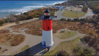
Photos of Outer Cape Mountain Bike
Videos of Outer Cape Mountain Bike
0:18 |
40 |
Aug 23, 2020
trail: Nauset Marsh Bike Path
5:24 |
365 |
Nov 26, 2021 , Eastham (Outer Cape)
Recent Trail Reports
Activity Feed
| username | action | type | title | date |
|---|---|---|---|---|
| Theodored5LMFI | add | report | activity #97325346 | Jun 19, 2026 @ 9:47am 1 day |
| cozzman | wishlist | route | activity #96516835 | Jun 7, 2026 @ 7:37pm Jun 7, 2026 |
| terry-amtb | wishlist | route | activity #96405657 | Jun 6, 2026 @ 2:15pm Jun 6, 2026 |
| DaveMass | add | report | activity #95958041 | May 31, 2026 @ 10:52am May 31, 2026 |
| LeahShatkin | wishlist | route | activity #93492214 | Apr 26, 2026 @ 6:02pm Apr 26, 2026 |
Recent Comments
| username | type | title | comment | date |
|---|---|---|---|---|
| trail | This is a fantastic singletrack section.... | Aug 25, 2024 @ 3:46pm Aug 25, 2024 | ||
| report | "Is due"? Please provide more info so that we... | Sep 28, 2023 @ 6:36am Sep 28, 2023 | ||
| report | Super overgrown, particularly on the western... | Jul 1, 2023 @ 9:03pm Jul 1, 2023 | ||
| trail | This is a great paved trail that is great for... | Nov 26, 2021 @ 8:15am Nov 26, 2021 |
Local Badges
-

Epic Mountain Bike Climb 2k0 awarded -

Descent 10k Badge0 awarded -

Epic Ride Descent 2k0 awarded -

Mountain Biking 100k Badge0 awarded -

Climbing 10k Badge0 awarded -
Descent 10k Badge0 awarded
Local Trail Supporters
![]()
- East Coast Greenway
Activity Type Stats
| activitytype | trails | distance | descent | descent distance | total vertical | rating | global rank | state rank | photos | reports | routes | ridelogs |
|---|---|---|---|---|---|---|---|---|---|---|---|---|
| Mountain Bike | 142 | 101 miles | 3,986 ft | 33 miles | 154 ft | 37 | 113 | 7 | 8,758 | |||
| E-Bike | 6 | 12 miles | 413 ft | 4 miles | 69 ft | 85 | 129 | |||||
| Hike | 365 | 203 miles | 9,423 ft | 67 miles | 174 ft | 6 | 117 | 6 | 826 | |||
| Trail Running | 363 | 203 miles | 9,416 ft | 66 miles | 174 ft | 1 | 117 | 4 | 496 | |||
| ATV/ORV/OHV | 1 | 1,903 ft | 20 ft | 751 ft | 20 ft | 4 | ||||||
| Snowmobile | 1 | 804 ft | 3 ft | |||||||||
| Snowshoe | 361 | 202 miles | 9,403 ft | 66 miles | 174 ft | 30 | 5 |
Frequently Asked Questions About Outer Cape
▼
What are the best places to ride in Outer Cape?
Outer Cape has 5 areas to explore for mountain biking. The top rated areas are:
▼
What are the highest rated mountain biking trails in Outer Cape?
The highest rated mountain biking trails in Outer Cape are:
- Nauset Marsh Bike Path (4.1/5)
- Clapp's & Duck Ponds Trail (4.1/5)
- Province Lands Bike Trail - Herring Cover Spur to Race Point Spur (0/5)
- Province Lands Bike Trail - Visitor Center Spur (0/5)
- Province Lands Bike Trail - Beech Forest Spur (0/5)
▼
What is the best time of the year to ride in Outer Cape?
Based on ride log data, the most popular months to ride in Outer Cape are:
- July (127 activities)
- August (113 activities)
- September (50 activities)
▼
What is the longest trail in Outer Cape?
The longest trail in Outer Cape is Province Lands Bike Trail - Herring Cover Spur to Race Point Spur at 3.4 miles. View all trails sorted by distance.
Activities
Trails
- By WillieJacobsz
 Trailforks SBP SWW & contributors
 - Admins: NEMBAEXEC, BCT, JimBallantyne, brucerioux, pjahnige, mappermook, CC NEMBA, capecolin
- #34880 - 1,587 views
- outer cape activity log | embed map of Outer Cape mountain bike trails | outer cape mountain biking points of interest polygons
Downloading of trail gps tracks in kml & gpx formats is enabled for Outer Cape.
You must login to download files.