close
-
Layers w
- Weather Layers
- Pro
- Pro
- Pro
- Pro
- Pro
- Pro
- More Layers
- Pro
- Pro
- Pro
- Pro
-
Upgrade to

3D
Trail Conditions
- Unknown
- Snow Groomed
- Snow Packed
- Snow Covered
- Snow Cover Partial
- Freeze/thaw Cycle
- Icy
- Prevalent Mud
- Wet
- Variable
- Ideal
- Dry
- Very Dry
Trail Flow (Ridden Direction)
Trailforks scans users ridelogs to determine the most popular direction each trail is ridden. A good flowing trail network will have most trails flowing in a single direction according to their intension.
The colour categories are based on what percentage of riders are riding a trail in its intended direction.
The colour categories are based on what percentage of riders are riding a trail in its intended direction.
- > 96%
- > 90%
- > 80%
- > 70%
- > 50%
- < 50%
- bi-directional trail
- no data
Trail Last Ridden
Trailforks scans ridelogs to determine the last time a trail was ridden.
- < 2 days
- < 1 week
- < 2 weeks
- < 1 month
- < 6 months
- > 6 months
Trail Ridden Direction
The intended direction a trail should be ridden.
- Downhill Only
- Downhill Primary
- Both Directions
- Uphill Primary
- Uphill Only
- One Direction
Contribute Details
Colors indicate trail is missing specified detail.
- Description
- Photos
- Description & Photos
- Videos
Trail Popularity ?
Trailforks scans ridelogs to determine which trails are ridden the most in the last 9 months.
Trails are compared with nearby trails in the same city region with a possible 25 colour shades.
Think of this as a heatmap, more rides = more kinetic energy = warmer colors.
- most popular
- popular
- less popular
- not popular
ATV/ORV/OHV Filter
Max Vehicle Width
inches
US Cell Coverage
Legend

Radar Time
Activity Recordings
Trailforks uses anonymized public activity data.
?
Activity Recordings
Trailforks uses anonymized public activity data.
?
Personal Heatmap
▶
Activity Types
all
/
none
▶
Options
2
Date range
month
–
Winter Trails
Warning
A routing network for winter maps does not exist. Selecting trails using the winter trails layer has been disabled.
Missing Trails
Most Popular
Least Popular
Trails are colored based on popularity. The more popular a trail is, the more red. Less popular trails trend towards green.
Jump Magnitude Heatmap
Heatmap of where riders jump on trails. Zoom in to see individual jumps, click circles to view jump details.
BC Backroad Status
![map legend]()
Service Road Atlas is a free to use, community-driven service for viewing and creating reports on the numerous back-country service roads around B.C. and Alberta.

Slope Aspect
Direction the slope faces
Trails Deemphasized
Trails are shown in grey.
Only show trails with no bike usage.
Suggested Layers
Based on selected activity type
Save the current map location and zoom level as your default home location whenever this page is loaded.
Save
No description for Palisade has been added yet!
Login or register to submit one.
Activities Click to view
- Mountain Bike
31 trails
- Gravel Bike
8 trails
- Winter Fat Bike
5 trails
- Horse
17 trails
- Hike
33 trails
- Trail Running
33 trails
- Nordic Ski
21 trails
Region Details
- 13
- 3
- 6
- 9
Region Status
Caution as of May 24, 2026Stats
- Avg Trail Rating
- Trails (view details)
- 51
- Trails Mountain Bike
- 31
- Trails E-Bike
- 9
- Trails Gravel Bike
- 8
- Trails Adaptive Bike
- 7
- Trails Winter Fat Bike
- 5
- Trails Horse
- 17
- Trails Hike
- 33
- Trails Trail Running
- 33
- Trails Dirtbike/Moto
- 10
- Trails ATV/ORV/OHV
- 11
- Trails Nordic Ski
- 21
- Total Distance
- 96 miles
- Total Descent
- 18,096 ft
- Total Vertical
- 6,111 ft
- Highest Trailhead
- 10,825 ft
- Reports
- 252
- Photos
- 106
- Ridden Counter
- 7,592
Sub Regions
-
Grand Mesa East
- 4
- 6
- 1
Popular Palisade Mountain Biking Trails
• 85 ★ 4.8 • 4,078 ft • 29 ft • 804 •
The last section of the drops into a deep canyon in a fun, technical, wild section of trail. The lower canyon section remains open when the rest of the is closed for annual wildlife closure December 1 -May 1. Riding the closed above the...
• 100 ★ 4.1 • 3,904 ft • 261 ft • 652 •
Highly rated popular black diamond difficulty singletrack. This mountain bike primary trail. On average it takes 11 minutes to complete this trail.
• 85 ★ 4.1 • 1 mile • 189 ft • 620 •
Technical ascending and descending up and along a sagebrush canyon. Can be filled with hikers especially the lower areas and on weekends. This trail flows best if you ride it clockwise, descend the SW portion, and climb the NE portion.
• 80 ★ 4.6 • 4 miles • 512 ft • 515 •
Highly rated popular black diamond difficulty singletrack. This mountain bike primary trail. On average it takes 45 minutes to complete this trail.
• 100 ★ 4.4 • 5,157 ft • 422 ft • 486 •
Technical ascending and descending up and along a sagebrush canyon. Can be filled with hikers especially the lower areas and on weekends.
• 70 ★ 3.5 • 18 miles • 1,287 ft • 393 •
Want to ride 32 miles of amazing singletrack? is open as of May 29, 2021! An epic point to point challenge, from the alpine aspen groves of the Grand Mesa to the desert shores of the Colorado River, the is truly a plunge through unique...
• 100 ★ 4.3 • 3 miles • 13 ft • 369 •
Easy flow trail that takes you from top to bottom.
• 80 ★ 4.2 • 2 miles • 20 ft • 349 •
This trail has it all. A bit of tech, a lot of flow, all fun.
Palisade Mountain Bike Routes
★ 3.7 • 31 miles • 1,622 ft • 4 • Shuttled •
The provides ~32 mi of trail atop the Grand Mesa and along its stunning west flank as it traverses and...
★ 4.0 • 17 miles • 587 ft • 5 • Shuttled •
The has already been called one of the most iconic trails in the country. It is also a trail most suitable...
★ 1.0 • 5 miles • 614 ft • 0 • Out & Back •
Wash/Gulley trail that parallels/crosses the access road multiple time. Very fun, very different...
• 13 miles • 1,804 ft • 9 •
• 6 miles • 1,160 ft • 7 •
• 30 miles • 2,561 ft • 1 •
Photos of Palisade Mountain Bike
Videos of Palisade Mountain Bike
29:06 |
100 |
Feb 15, 2025
3:35 |
65 |
Jan 29, 2025
youtuber
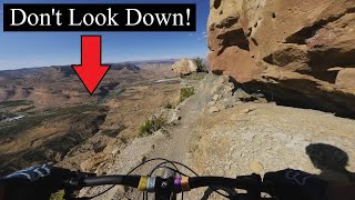
![The Palisade Plunge]()
trail: Palisade Plunge
16:49 |
763 |
Sep 2, 2022 , Palisade
youtuber
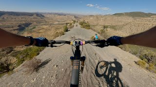
![The Palisade Plunge Experience | Western Slope...]()
11:31 |
683 |
Oct 30, 2021 , Palisade
youtuber
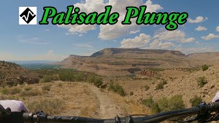
![The Palisade Plunge is Here // Phase I, Lands...]()
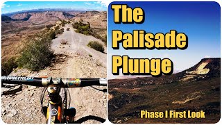
trail: Palisade Plunge
32:35 |
1114 |
Jun 6, 2021 , Palisade
youtuber
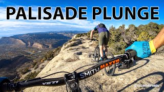
![Mountain Biking: Palisade Rim, Palisades, Colorado]()
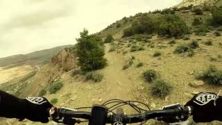
trail: Palisade Rim (lower)
6:44 |
458 |
Jan 26, 2020 , Palisade

trail: Palisade Rim (upper)
9:05 |
1390 |
Jun 1, 2018 , Palisade
trail: Palisade Rim (lower)
9:05 |
449 |
Jun 1, 2018 , Palisade
Recent Trail Reports
| status | trail | date | condition | info | user |
|---|---|---|---|---|---|
| Palisade Plunge | May 24, 2026 @ 1:19pm (America/Denver) May 24, 2026 | Dry | mattm254 COPMOBA-GVT | ||
| Palisade Rim (upper) | May 15, 2026 @ 11:57am (America/Denver) May 15, 2026 | Dry | Jordanb22 | ||
| Palisade Rim | Feb 25, 2026 @ 2:18pm (America/Denver) Feb 25, 2026 | Freeze/thaw Cycle | BCBassett | ||
| Palisade Rim (lower) | Feb 25, 2026 @ 2:18pm (America/Denver) Feb 25, 2026 | Freeze/thaw Cycle | BCBassett | ||
| Palisade Plunge - Upper Canyon | Feb 25, 2026 @ 2:18pm (America/Denver) Feb 25, 2026 | Freeze/thaw Cycle | BCBassett | ||
| Plunge to Rim Connector - Lower | Feb 25, 2026 @ 2:18pm (America/Denver) Feb 25, 2026 | Freeze/thaw Cycle | BCBassett | ||
| Palisade Plunge - Lower Canyon | Sep 30, 2025 @ 9:37am (America/Denver) Sep 30, 2025 | Dry | eLBy Alsea Falls TC | ||
| Coal Canyon - BLM 300 | Jan 11, 2025 @ 2:24pm Jan 11, 2025 | Snow Cover Partial | randyfay | ||
| Mutton Buster | Aug 3, 2024 @ 5:35am Aug 3, 2024 | Variable | rlaca001 | ||
| Hither | Jun 30, 2024 @ 12:45pm Jun 30, 2024 | Ideal | ryrob PMR |
Activity Feed
| username | action | type | title | date |
|---|---|---|---|---|
| mattm254 | update | region | activity #97491848 | Jun 21, 2026 @ 9:13am Jun 21, 2026 |
| mattm254 | add | trail | activity #97489638 and 1 more | Jun 21, 2026 @ 8:50am Jun 21, 2026 |
| AsZmUf | wishlist | trail | activity #97456119 | Jun 20, 2026 @ 10:36pm Jun 20, 2026 |
| Downhillbothways | wishlist | trail | activity #97335158 | Jun 19, 2026 @ 11:59am Jun 19, 2026 |
| ggK7Um | vote | trail | activity #96716361 | Jun 10, 2026 @ 8:40pm Jun 10, 2026 |
Recent Comments
| username | type | title | comment | date |
|---|---|---|---|---|
| trail | I rode up from river about 10 miles, to... | Jun 3, 2026 @ 4:36pm Jun 3, 2026 | ||
| trail | This was an amazing adventure trail. I had fun... | Jun 19, 2025 @ 10:42am Jun 19, 2025 | ||
| trail | Awesome adventure ride! Anyone that says you... | Nov 25, 2024 @ 8:09pm Nov 25, 2024 | ||
| trail | I think you are spot on. Especially with the... | Sep 25, 2024 @ 1:24pm Sep 25, 2024 | ||
| trail | If the trail was called the Palisade traverse... | Sep 25, 2024 @ 11:31am Sep 25, 2024 |
Local Badges
-

Epic Mountain Bike Climb 2k33 awarded -

Climbing 10k Badge8 awarded -

Mountain Biking 100k Badge1 awarded -

Epic Ride Descent 2k33 awarded -

Descent 10k Badge11 awarded -

Descent 100k Badge1 awarded
Activity Type Stats
| activitytype | trails | distance | descent | descent distance | total vertical | rating | global rank | state rank | photos | reports | routes | ridelogs |
|---|---|---|---|---|---|---|---|---|---|---|---|---|
| Mountain Bike | 31 | 61 miles | 15,043 ft | 32 miles | 6,017 ft | #2,662 | #952 | 106 | 247 | 3 | 4,019 | |
| E-Bike | 9 | 7 miles | 610 ft | 1 mile | 896 ft | 168 | 91 | |||||
| Gravel Bike | 8 | #698 | #1,182 | 1 | 5 | |||||||
| Adaptive Bike | 7 | #1,004 | #550 | |||||||||
| Winter Fat Bike | 5 | #415 | #1,159 | |||||||||
| Horse | 17 | 36 miles | 4,367 ft | 17 miles | 5,909 ft | #1,341 | #811 | 54 | 1 | |||
| Hike | 33 | 74 miles | 14,403 ft | 36 miles | 6,017 ft | #3,600 | #1,268 | 234 | 2 | 858 | ||
| Trail Running | 33 | 74 miles | 14,403 ft | 36 miles | 6,017 ft | #3,185 | #932 | 234 | 2 | 204 | ||
| Dirtbike/Moto | 10 | 7 miles | 610 ft | 1 mile | 896 ft | 30 | 1 | 13 | ||||
| ATV/ORV/OHV | 11 | 7 miles | 610 ft | 1 mile | 896 ft | 30 | 1 | 1 | ||||
| Nordic Ski | 21 | 16 miles | 390 ft | 4 miles | 226 ft | #739 | #275 | 23 | 283 |
Frequently Asked Questions About Palisade
▼
What are the best places to ride in Palisade?
Palisade has 3 areas to explore for mountain biking. The top rated areas are:
▼
What are the highest rated mountain biking trails in Palisade?
The highest rated mountain biking trails in Palisade are:
- Palisade Plunge - Lower Canyon (4.5/5)
- Palisade Rim (upper) (4.4/5)
- Blue Ribbon (4.2/5)
- Palisade Rim (4.2/5)
- Mutton Buster (4.1/5)
▼
What is the best time of the year to ride in Palisade?
Based on ride log data, the most popular months to ride in Palisade are:
- October (36 activities)
- August (28 activities)
- May (27 activities)
▼
Where can I park to ride in Palisade?
There are 10 parking locations listed in Palisade. The most popular parking spots are: View all parking and trailhead locations on the map to plan your visit.
Activities
Trails
- By brenthillier
 NSMBA TRAILFORKS & contributors
 - Admins: COPMOBA-GVT
- #3490 - 8,354 views
- palisade activity log | embed map of Palisade mountain bike trails | palisade mountain biking points of interest
Downloading of trail gps tracks in kml & gpx formats is enabled for Palisade.
You must login to download files.