close
-
Layers w
- Weather Layers
- Pro
- Pro
- Pro
- Pro
- Pro
- Pro
- More Layers
- Pro
- Pro
- Pro
- Pro
-
Upgrade to

3D
Trail Conditions
- Unknown
- Snow Groomed
- Snow Packed
- Snow Covered
- Snow Cover Partial
- Freeze/thaw Cycle
- Icy
- Prevalent Mud
- Wet
- Variable
- Ideal
- Dry
- Very Dry
Trail Flow (Ridden Direction)
Trailforks scans users ridelogs to determine the most popular direction each trail is ridden. A good flowing trail network will have most trails flowing in a single direction according to their intension.
The colour categories are based on what percentage of riders are riding a trail in its intended direction.
The colour categories are based on what percentage of riders are riding a trail in its intended direction.
- > 96%
- > 90%
- > 80%
- > 70%
- > 50%
- < 50%
- bi-directional trail
- no data
Trail Last Ridden
Trailforks scans ridelogs to determine the last time a trail was ridden.
- < 2 days
- < 1 week
- < 2 weeks
- < 1 month
- < 6 months
- > 6 months
Trail Ridden Direction
The intended direction a trail should be ridden.
- Downhill Only
- Downhill Primary
- Both Directions
- Uphill Primary
- Uphill Only
- One Direction
Contribute Details
Colors indicate trail is missing specified detail.
- Description
- Photos
- Description & Photos
- Videos
Trail Popularity ?
Trailforks scans ridelogs to determine which trails are ridden the most in the last 9 months.
Trails are compared with nearby trails in the same city region with a possible 25 colour shades.
Think of this as a heatmap, more rides = more kinetic energy = warmer colors.
- most popular
- popular
- less popular
- not popular
ATV/ORV/OHV Filter
Max Vehicle Width
inches
US Cell Coverage
Legend

Radar Time
Activity Recordings
Trailforks uses anonymized public activity data.
?
Activity Recordings
Trailforks uses anonymized public activity data.
?
Personal Heatmap
▶
Activity Types
all
/
none
▶
Options
2
Date range
month
–
Winter Trails
Warning
A routing network for winter maps does not exist. Selecting trails using the winter trails layer has been disabled.
Missing Trails
Most Popular
Least Popular
Trails are colored based on popularity. The more popular a trail is, the more red. Less popular trails trend towards green.
Jump Magnitude Heatmap
Heatmap of where riders jump on trails. Zoom in to see individual jumps, click circles to view jump details.
BC Backroad Status
![map legend]()
Service Road Atlas is a free to use, community-driven service for viewing and creating reports on the numerous back-country service roads around B.C. and Alberta.

Slope Aspect
Direction the slope faces
Trails Deemphasized
Trails are shown in grey.
Only show trails with no bike usage.
Suggested Layers
Based on selected activity type
Save the current map location and zoom level as your default home location whenever this page is loaded.
Save
No description for Palm Desert has been added yet!
Login or register to submit one.
Activities Click to view
- Mountain Bike
18 trails
- E-Bike
4 trails
- Gravel Bike
0 trails
- Adaptive Bike
0 trails
- Hike
36 trails
- Trail Running
36 trails
Region Details
- 1
- 3
- 10
- 2
Region Status
Caution as of Feb 15, 2026Stats
- Avg Trail Rating
- Trails (view details)
- 33
- Trails Mountain Bike
- 18
- Trails E-Bike
- 4
- Trails Horse
- 2
- Trails Hike
- 36
- Trails Trail Running
- 36
- Trails Dirtbike/Moto
- 1
- Trails ATV/ORV/OHV
- 1
- Total Distance
- 85 miles
- Total Descent
- 17,690 ft
- Total Vertical
- 8,013 ft
- Highest Trailhead
- 8,239 ft
- Reports
- 72
- Photos
- 193
- Ridden Counter
- 2,035
Sub Regions
-
Coachella Valley Preserve
Popular Palm Desert Mountain Biking Trails
• 75 ★ 4.3 • 8 miles • 860 ft • 162 •
This ride is located north of Palm Desert in the Santa Rosa Mountains National Scenic Area. From its origin in Dead Indian Canyon, this 16.7-mile out-and-back singletrack route takes you through a diverse desert garden of cacti s you...
• 100 ★ 0.0 • 2,343 ft • 29 ft • 137 •
Popular green difficulty singletrack. This mountain bike primary trail can be used both directions. On average it takes 3 minutes to complete this trail.
• 40 ★ 3.8 • 4 miles • 1,200 ft • 106 •
This is a good out and back singletrack trail if you ride up to the cross viewpoint and back. Along with the undulating trail, you'll be in for a good climb, about 900 ft. Once you reach the top, you'll be treated to a very fun downhill...
• 95 ★ 3.0 • 1 mile • 286 ft • 98 •
The is actually comprised of 3 trails - the Desert Wash Loop, the Cholla Loop and the Canyon Loop . That's a lot to pack into 2.4 miles, but as with most desert riding, these are long miles.
• 70 ★ 3.0 • 4,439 ft • 257 ft • 81 • • hike
The is a connector trail that gets you to the and Bump n' Grind Trails. FYI: is a trail builder and has built most of the trails in the Palm Desert area for the City of Palm Desert. Be prepared and have fun.
• 80 ★ 4.0 • 1,693 ft • 157 ft • 66 • • hike
to Loop is a lightly trafficked loop trail located near Palm Desert, California that offers scenic views and is rated as moderate.
• 90 ★ 2.8 • 1 mile • 18 ft • 46 •
Bump & Grind is a fairly wide open trail that starts with some pretty steep climbing with tight switchbacks. After leveling off a bit you have really great bench-cut singletrack through the mountainside with incredible views of the...
• 65 ★ 0.0 • 3,765 ft • 334 ft • 45 •
This is a very popular park because the Homestead Trail is the trail to the Palm Desert Cross. The Homestead Trail intersects with the Hopalong Cassidy Trail on the way to the Cross. The hike is steep but not difficult.
Palm Desert Mountain Bike Routes
★ 5.0 • 19 miles • 3,570 ft • 1 • Loop •
Enjoy a nice warm up loop on the Randall-Henderson Loop before taking on the tough Art Smith Out-and-back....
★ 3.0 • 27 miles • 2,291 ft • 4 • Shuttled •
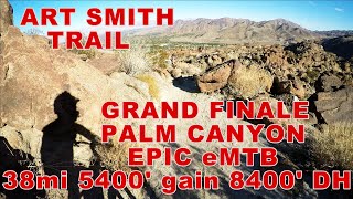
Shuttle Ride starting on to Art Smith to downhills Goat Trail to Palm Desert
5 miles • 1,227 ft • 3 • Loop •
Undulating trail mostly, and you'll be in for a good climb with a couple hike-a-bike sections. Once you...
2 miles • 394 ft • 2 •
Undulating trail mostly, and you'll be in for a good climb with a couple hike-a-bike sections. Once you...
32 miles • 3,739 ft • 6 • Point to Point •
Section 5 of a series of connecting mountain bike trails from Southern California to Canada. This section...
21 miles • 3,822 ft • 2 • Loop •
This loop will take you up Santa Rosa Mountain for some fantastic views before having you descend the...
Photos of Palm Desert Mountain Bike
Videos of Palm Desert Mountain Bike
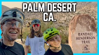
trail: Randall Henderson Loop
9:29 |
129 |
Jun 10, 2024 , Palm Desert
19:16 |
497 |
Dec 17, 2021 , Palm Desert
4:22 |
686 |
Dec 17, 2021 , Palm Desert
youtuber
![Mountain Biking Art Smith Trail at Night -...]()

15:40 |
863 |
Jan 13, 2020 , Palm Desert
youtuber
![Mountain Biking with the New Gopro Hero 8...]()

15:00 |
771 |
Dec 23, 2019 , Palm Desert

14:42 |
565 |
Dec 23, 2019 , Palm Desert
4:49 |
350 |
Jun 29, 2018 , Palm Desert
Recent Trail Reports
| status | trail | date | condition | info | user |
|---|---|---|---|---|---|
| Herb Jefferies Trail | Jan 28, 2026 @ 9:07am (America/Los_Angeles) Jan 28, 2026 | Ideal | steppi604 | ||
| Mike Schuler Trail | Jan 28, 2026 @ 9:07am (America/Los_Angeles) Jan 28, 2026 | Ideal | steppi604 | ||
| Gabby Hayes Trail | Jan 3, 2026 @ 4:01pm (America/Tijuana) Jan 3, 2026 | Unknown | stu1WrcPL | ||
| Gabby Hayes | Jan 3, 2026 @ 4:01pm (America/Tijuana) Jan 3, 2026 | Ideal | stu1WrcPL | ||
| Randall Henderson Loop | Dec 18, 2025 @ 8:32am (America/Los_Angeles) Dec 18, 2025 | Ideal | DaveFazzone | ||
| Randall Henderson Loop Trail | Nov 17, 2025 @ 7:52am (America/Tijuana) Nov 17, 2025 | Ideal | stu1WrcPL | ||
| Hopalong Cassidy North | Oct 4, 2025 @ 4:33pm (America/Los_Angeles) Oct 4, 2025 | Dry | darshahlu WSMTBC | ||
| Art Smith Trail from Dunn Rd. | Oct 4, 2025 @ 1:27pm (Pacific/Midway) Oct 4, 2025 | Dry | darshahlu WSMTBC | ||
| Santa Rosa Truck Trail | May 24, 2025 @ 7:21am May 24, 2025 | Very Dry | DaveFazzone | ||
| Bump and Grind Trail | Feb 21, 2025 @ 10:15am Feb 21, 2025 | Very Dry | mpatt |
Activity Feed
| username | action | type | title | date |
|---|---|---|---|---|
| astroguy0 | comment | trail | activity #95228282 | May 22, 2026 @ 1:41am May 22, 2026 |
| JRSMITH116 | ridden | trail | activity #93924790 and 1 more | May 3, 2026 @ 1:53am May 3, 2026 |
| JRSMITH116 | add | photo | activity #93924621 and 3 more | May 3, 2026 @ 1:49am May 3, 2026 |
| nateboarding | wishlist | trail | activity #93634837 | Apr 29, 2026 @ 2:13am Apr 29, 2026 |
| dougfaker | wishlist | route | activity #92335876 | Apr 10, 2026 @ 12:07pm Apr 10, 2026 |
Recent Comments
| username | type | title | comment | date |
|---|---|---|---|---|
| trail | Did the full out and back - 16 mi, 1024... | May 22, 2026 @ 1:41am May 22, 2026 | ||
| report | This trail report must be based on the... | Oct 4, 2025 @ 4:59pm Oct 4, 2025 | ||
| trail | I suggest we split this trail into two... | Oct 4, 2025 @ 4:57pm Oct 4, 2025 | ||
| trail | Rode this as an out and back to the 8 km mark... | May 7, 2025 @ 12:20pm May 7, 2025 | ||
| trail | Does anyone organize to work on this trail? | Jan 20, 2025 @ 9:35am Jan 20, 2025 |
Local Badges
-

Epic Mountain Bike Climb 2k6 awarded -

Climbing 10k Badge9 awarded -

Mountain Biking 100k Badge0 awarded -

Epic Ride Descent 2k6 awarded -

Descent 10k Badge10 awarded -

Descent 100k Badge0 awarded
Local Mountain Biking Directory
-
Tri-a-bikeBike Shop
-
FunseekersBike Shop
-
Palm Desert CycleryBike Shop
Activity Type Stats
| activitytype | trails | distance | descent | descent distance | total vertical | rating | global rank | state rank | photos | reports | routes | ridelogs |
|---|---|---|---|---|---|---|---|---|---|---|---|---|
| Mountain Bike | 18 | 51 miles | 13,340 ft | 30 miles | 8,015 ft | #3,958 | #1,330 | 206 | 72 | 12 | 5,885 | |
| E-Bike | 4 | 21 miles | 5,932 ft | 15 miles | 8,015 ft | #3,987 | #1,327 | 57 | 701 | |||
| Horse | 2 | 20 miles | 3,583 ft | 7 miles | 2,631 ft | 10 | 1 | |||||
| Hike | 36 | 85 miles | 17,690 ft | 41 miles | 8,015 ft | #2,531 | #996 | 5 | 72 | 3 | 1,633 | |
| Trail Running | 36 | 85 miles | 17,690 ft | 41 miles | 8,015 ft | #2,668 | #766 | 72 | 3 | 270 | ||
| Dirtbike/Moto | 1 | 12 miles | 3,970 ft | 10 miles | 3,652 ft | 9 | 1 | 2 | ||||
| ATV/ORV/OHV | 1 | 12 miles | 3,970 ft | 10 miles | 3,652 ft | 9 | 1 | 1 |
Frequently Asked Questions About Palm Desert
▼
What are the best places to ride in Palm Desert?
Palm Desert has 1 areas to explore for mountain biking.
▼
What are the highest rated mountain biking trails in Palm Desert?
The highest rated mountain biking trails in Palm Desert are:
- Randall Henderson Loop Trail (4.1/5)
- Art Smith Trail from Dunn Rd. (4.1/5)
- Gabby Hayes Trail (4/5)
- Gabby Hayes (4/5)
- Sawmill Trail (3.9/5)
▼
What is the best time of the year to ride in Palm Desert?
Based on ride log data, the most popular months to ride in Palm Desert are:
- November (27 activities)
- February (20 activities)
- December (18 activities)
▼
Where can I park to ride in Palm Desert?
Activities
Trails
- By brenthillier
 NSMBA TRAILFORKS & contributors
 - Admins: IVMTB
- #10328 - 26,161 views
- palm desert activity log | embed map of Palm Desert mountain bike trails | palm desert mountain biking points of interest
Downloading of trail gps tracks in kml & gpx formats is enabled for Palm Desert.
You must login to download files.