close
-
Layers w
- Weather Layers
- Pro
- Pro
- Pro
- Pro
- Pro
- Pro
- More Layers
- Pro
- Pro
- Pro
- Pro
-
Upgrade to

3D
Trail Conditions
- Unknown
- Snow Groomed
- Snow Packed
- Snow Covered
- Snow Cover Partial
- Freeze/thaw Cycle
- Icy
- Prevalent Mud
- Wet
- Variable
- Ideal
- Dry
- Very Dry
Trail Flow (Ridden Direction)
Trailforks scans users ridelogs to determine the most popular direction each trail is ridden. A good flowing trail network will have most trails flowing in a single direction according to their intension.
The colour categories are based on what percentage of riders are riding a trail in its intended direction.
The colour categories are based on what percentage of riders are riding a trail in its intended direction.
- > 96%
- > 90%
- > 80%
- > 70%
- > 50%
- < 50%
- bi-directional trail
- no data
Trail Last Ridden
Trailforks scans ridelogs to determine the last time a trail was ridden.
- < 2 days
- < 1 week
- < 2 weeks
- < 1 month
- < 6 months
- > 6 months
Trail Ridden Direction
The intended direction a trail should be ridden.
- Downhill Only
- Downhill Primary
- Both Directions
- Uphill Primary
- Uphill Only
- One Direction
Contribute Details
Colors indicate trail is missing specified detail.
- Description
- Photos
- Description & Photos
- Videos
Trail Popularity ?
Trailforks scans ridelogs to determine which trails are ridden the most in the last 9 months.
Trails are compared with nearby trails in the same city region with a possible 25 colour shades.
Think of this as a heatmap, more rides = more kinetic energy = warmer colors.
- most popular
- popular
- less popular
- not popular
ATV/ORV/OHV Filter
Max Vehicle Width
inches
US Cell Coverage
Legend

Radar Time
Activity Recordings
Trailforks uses anonymized public activity data.
?
Activity Recordings
Trailforks uses anonymized public activity data.
?
Personal Heatmap
▶
Activity Types
all
/
none
▶
Options
2
Date range
month
–
Winter Trails
Warning
A routing network for winter maps does not exist. Selecting trails using the winter trails layer has been disabled.
Missing Trails
Most Popular
Least Popular
Trails are colored based on popularity. The more popular a trail is, the more red. Less popular trails trend towards green.
Jump Magnitude Heatmap
Heatmap of where riders jump on trails. Zoom in to see individual jumps, click circles to view jump details.
BC Backroad Status
![map legend]()
Service Road Atlas is a free to use, community-driven service for viewing and creating reports on the numerous back-country service roads around B.C. and Alberta.

Slope Aspect
Direction the slope faces
Trails Deemphasized
Trails are shown in grey.
Only show trails with no bike usage.
Suggested Layers
Based on selected activity type
Save the current map location and zoom level as your default home location whenever this page is loaded.
SavePamplona (cooficialmente en euskera Iruña, según Euskaltzaindia Iruñea)3 es un municipio y ciudad española, capital de Navarra.
Pamplona está ubicada en el norte de la península ibérica, y en el centro de la cuenca de Pamplona. Se extiende a ambas orillas del río Arga y por ella discurren otros dos ríos, el Elorz (afluente del Arga) y el Sadar (afluente del Elorz). Cuenta con una población de 203 944 habitantes (INE, 2020) repartida en una superficie de 25 098 km², según los datos del registro municipal. Su área metropolitana alcanza los 334 830 habitantes distribuidos en una superficie de 488,6 km².4
Pamplona está ubicada en el norte de la península ibérica, y en el centro de la cuenca de Pamplona. Se extiende a ambas orillas del río Arga y por ella discurren otros dos ríos, el Elorz (afluente del Arga) y el Sadar (afluente del Elorz). Cuenta con una población de 203 944 habitantes (INE, 2020) repartida en una superficie de 25 098 km², según los datos del registro municipal. Su área metropolitana alcanza los 334 830 habitantes distribuidos en una superficie de 488,6 km².4
eBikes Allowed:
Yes
AKA: Iruña
This region uses the Uk/Euro style trail grading system.
Activities Click to view
- Mountain Bike
3,074 trails
- E-Bike
3,047 trails
- Gravel Bike
56 trails
- Adaptive Bike
75 trails
- Winter Fat Bike
30 trails
- Horse
47 trails
- Hike
3,135 trails
- Trail Running
3,111 trails
- Dirtbike/Moto
16 trails
Region Details
- 1,776
- 31
- 70
- 998
- 187
- 10
Region Status
Open as of 6 hoursStats
- Avg Trail Rating
- Trails (view details)
- 3,155
- Trails Mountain Bike
- 3,074
- Trails E-Bike
- 3,047
- Trails Gravel Bike
- 56
- Trails Adaptive Bike
- 75
- Trails Winter Fat Bike
- 30
- Trails Horse
- 47
- Trails Hike
- 3,135
- Trails Trail Running
- 3,111
- Trails Dirtbike/Moto
- 16
- Trails Observed Trials
- 1
- Trails Backcountry Ski
- 2
- Trails Nordic Ski
- 2
- Total Distance
- 3,281 miles
- Total Descent Distance
- 1,537 miles
- Total Descent
- 545,820 ft
- Total Vertical
- 5,011 ft
- Highest Trailhead
- 5,081 ft
- Reports
- 8,966
- Photos
- 1,643
- Ridden Counter
- 46,769
Sub Regions
-
Aoiz
- 2
- 16
- 6
-
Aranguren
- 9
- 60
- 9
- 1
-
Artajona
- 42
- 2
-
Artikutza
-
Aurizberri/Espinal
- 2
- 22
- 2
-
Caparroso-Melida
- 7
-
Comarca de Pamplona
- 4
- 11
- 37
- 8
-
El Perdon/Erreniega
- 3
- 74
- 3
-
Elizondo
- 5
- 1
- 1
-
Eltxumendi
- 1
- 4
- 17
- 1
-
Etxauri-Izkue
- 2
- 48
- 13
-
Ezkaba/Iruña Norte
- 2
- 6
- 70
- 19
- 3
-
Falces
- 18
- 1
-
Irrisarri Land
- 1
- 2
- 2
- 1
-
Irurtzun
- 19
- 5
-
Izaga
- 1
- 10
- 8
-
Larraga
- 29
-
Larzabal-Amiñagain
- 1
- 4
- 20
- 7
-
Luzaide/Valcarlos
-
Miranda de Arga
- 28
-
Muskitz/Imotz
- 1
- 25
- 2
-
Olza-Lete
- 17
- 5
-
Oroz-Betelu
- 19
- 2
-
Otxondo
- 27
- 4
-
Santesteban-Donamaria
- 1
- 1
- 47
- 15
- 2
-
Sierra de Alaiz
- 1
- 35
- 6
-
Sorogain
- 1
- 16
- 5
-
Tafalla
- 6
- 73
- 4
-
Ultzamaldea
- 3
- 29
- 1
-
Unanua/Unanu
- 3
- 1
-
Valdizarbe-Puente la Reina
- 1
- 132
- 25
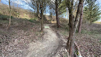
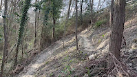
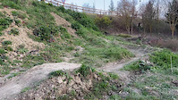
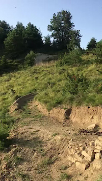
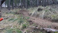
Popular Pamplona Mountain Biking Trails
• 100 ★ 2.0 • 1 mile • 32 ft • 203 •
Popular white difficulty family friendly paved path. This multi-use trail can be used both directions and has a easy overall physical rating with a 32 ft green climb. Trail visibility is always easy to follow. On average it takes 7 minutes to complete this trail.
• 100 ★ 3.7 • 515 ft • 24 ft • 198 •
Popular blue difficulty singletrack. This multi-use trail can be used uphill primary and has a moderate overall physical rating with a 24 ft blue climb. Trail visibility is sometimes hard to follow. On average it takes 1 minutes to complete this trail.
• 100 ★ 2.5 • 4 miles • 1,046 ft • 135 •
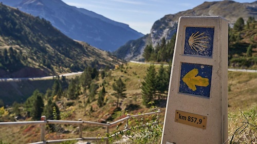
Tramo del Camino de Santiago desde Cizur Mayor hasta el collado del Perdon,donde el monumento a los peregrinos
• 100 ★ 1.0 • 2,687 ft • 25 ft • 125 •
Popular white difficulty paved path. This multi-use trail can be used both directions and has a easy overall physical rating with a 25 ft green climb. Trail visibility is always easy to follow. On average it takes 4 minutes to complete this trail.
• 100 ★ 4.5 • 3,455 ft • 17 ft • 115 •
Sendero que baja con suavidad con muchas curvas, algunas peraltadas. Desde la cresta Oeste hasta cerca del parking de la cantera y en paralelo a la pista roja. Para enlazar con la
• 100 ★ 5.0 • 3,317 ft • 154 ft • 111 •
Popular blue difficulty singletrack. This multi-use trail can be used uphill primary and has a moderate overall physical rating with a 154 ft blue climb. Trail visibility is sometimes hard to follow. On average it takes 13 minutes to complete this trail.
Pamplona Mountain Bike Routes
★ 4.5 • 24 miles • 3,838 ft • 26 • Loop •
Después de las tormentas de los días anterior los guías optaron por ir a Artajona y apoyados por...
★ 4.0 • 17 miles • 1,741 ft • 14 • Loop •
Posiblemente estemos ante la ruta más espectacular de la Zona Media en cuanto a senderos se refiere. Si...
★ 5.0 • 39 miles • 5,955 ft • 44 • Loop •
Valdi-extrem larga 2025 Valdiextrem nació como una carrera de montaña en del Perdón y el Valle de...
★ 5.0 • 15 miles • 3,167 ft • 9 • Loop •
Salida desde el albergue de Sorogain,subida dura pero muy entretenida,faldeamos el Adi y hacemos la...
★ 4.0 • 33 miles • 4,526 ft • 5 • Point to Point •
Un paseo por el medievo En el valle de Malerreka, flanqueada por varios montes como el de Mendaur, se...
★ 5.0 • 20 miles • 4,396 ft • 12 • Loop •
Tremenda vuelta al Adi,con paisajes pirenaicos y con las dos preciosas bajadas al Sorogain.Salida desde la...
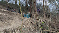
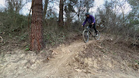
Photos of Pamplona Mountain Bike
Videos of Pamplona Mountain Bike
0:15 |
13 |
Apr 7, 2025
0:08 |
7 |
Apr 7, 2025
0:10 |
23 |
Apr 7, 2025
0:05 |
18 |
Apr 7, 2025
0:52 |
17 |
Apr 7, 2025
trail: Zona Limite
0:13 |
79 |
Feb 20, 2025
trail: Zona Limite
0:11 |
43 |
Jan 24, 2025
trail: Goldaraz Hermana Mayor
0:16 |
|
Nov 24, 2023
Current Trail Warnings
| status | trail | date | condition | user | info |
|---|---|---|---|---|---|
| Alzorriz | Jun 6, 2026 @ 9:04am (Europe/Andorra) Jun 6, 2026 | Dry | Crisjaca | E-Bike Muy muy cerrado, tanto la trazada, como... | |
| Plaxa I | Jun 3, 2026 @ 8:21am (Europe/Madrid) Jun 2, 2026 | Dry | Shuco636 | Muy cerrado de vegetación, teniendo en... | |
| Nueva | May 27, 2026 @ 3:32pm (Europe/Andorra) May 27, 2026 | Dry | efefunk | E-Bike |
Recent Trail Reports
| status | trail | date | condition | info | user |
|---|---|---|---|---|---|
| Balseta | Jun 18, 2026 @ 10:10pm (Europe/Madrid) 6 hours | Unknown | Roussimof | ||
| Gorosti Bizkar | Jun 18, 2026 @ 6:17pm (Europe/Andorra) 10 hours | Dry | northernbraaap Eremua | ||
| Zagua | Jun 18, 2026 @ 6:17pm (Europe/Andorra) 10 hours | Dry | northernbraaap Eremua | ||
| Enekorri | Jun 18, 2026 @ 6:17pm (Europe/Andorra) 10 hours | Dry | northernbraaap Eremua | ||
| Karrobide | Jun 18, 2026 @ 2:10am (Europe/Andorra) 1 day | Dry | Angelreing TFSPAIN | ||
| Moraun | Jun 18, 2026 @ 2:10am (Europe/Andorra) 1 day | Dry | Angelreing TFSPAIN | ||
| Orreal | Jun 18, 2026 @ 2:10am (Europe/Andorra) 1 day | Dry | Angelreing TFSPAIN | ||
| Lakidain-Irulegi | Jun 18, 2026 @ 2:10am (Europe/Andorra) 1 day | Ideal | Angelreing TFSPAIN | ||
| Irulegui - Lakibidea sendero | Jun 18, 2026 @ 2:10am (Europe/Andorra) 1 day | Ideal | Angelreing TFSPAIN | ||
| Lakibidea | Jun 18, 2026 @ 2:10am (Europe/Andorra) 1 day | Dry | Angelreing TFSPAIN |
National Scenic Trails & Official Routes
-
GR 65.3 Camino Francés por Aragón
- Mountain Bike
- E-Bike
- Horse
- Hike
- Trail Running
-
GR-65 Camino de Santiago
- Mountain Bike
- E-Bike
- Hike
- Trail Running
Activity Feed
| username | action | type | title | date |
|---|---|---|---|---|
| Roussimof | add | report | activity #97272218 | Jun 18, 2026 @ 1:10pm 6 hours |
| northernbraaap | add | report | activity #97269025 and 2 more | Jun 18, 2026 @ 12:18pm 7 hours |
| Angelreing | add | report | activity #97233278 and 5 more | Jun 17, 2026 @ 10:36pm 20 hours |
| Angelreing | add | photo | activity #97198362 | Jun 17, 2026 @ 11:25am 1 day |
| Angelreing | add | report | activity #97198348 | Jun 17, 2026 @ 11:24am 1 day |
Recent Comments
| username | type | title | comment | date |
|---|---|---|---|---|
| trail | Factible la subida con e-bike sin tener que... | Jun 6, 2026 @ 8:12am Jun 6, 2026 | ||
| trail | Que sendero más guapoooooo😍😍 solo hay... | Jun 6, 2026 @ 7:38am Jun 6, 2026 | ||
| trail | Que pena de sendero, super vestido de... | Jun 6, 2026 @ 7:36am Jun 6, 2026 | ||
| trail | Recortado ese tramo de pista, gracias. | Jun 4, 2026 @ 9:17pm Jun 4, 2026 | ||
| trail | Vista satelite, mas de la mitad es pista, 2/3... | Jun 4, 2026 @ 11:54am Jun 4, 2026 |
Local Badges
-

Diablo de Ezkaba10 awarded -

Completionist0 awarded -
Completionist0 awarded -
Completionist0 awarded -
Completionist0 awarded -
Completionist0 awarded
Bike & Skill Parks
| name | type | city | rating |
|---|---|---|---|
| Irrisarri Land | bike park | Pamplona | |
| Ororbia bikepark | skill park | Pamplona | |
| Pumptrack Iruña | skill park | Pamplona | |
| Pumptrack Sarriguren | skill park | Pamplona | |
| Berriozar Pumptrack | skill park | Pamplona |
Activity Type Stats
| activitytype | trails | distance | descent | descent distance | total vertical | rating | global rank | state rank | photos | reports | routes | ridelogs |
|---|---|---|---|---|---|---|---|---|---|---|---|---|
| Mountain Bike | 3,074 | 3,209 miles | 526,555 ft | 1,507 miles | 5,013 ft | #13 | #1 | 1,526 | 8,961 | 59 | 28,512 | |
| E-Bike | 3,047 | 3,178 miles | 518,898 ft | 1,488 miles | 5,013 ft | #1 | #2 | 19 | 8,617 | 57 | 5,312 | |
| Gravel Bike | 56 | 47 miles | 6,798 ft | 23 miles | 3,553 ft | #34 | #24 | 333 | 14 | 278 | ||
| Adaptive Bike | 75 | 72 miles | 10,758 ft | 34 miles | 3,773 ft | #19 | #40 | 205 | 2 | 2 | ||
| Winter Fat Bike | 30 | 36 miles | 7,211 ft | 21 miles | 3,228 ft | #27 | #10 | 44 | ||||
| Horse | 47 | 58 miles | 10,787 ft | 23 miles | 4,239 ft | #150 | #13 | 567 | ||||
| Hike | 3,135 | 3,259 miles | 538,583 ft | 1,524 miles | 5,013 ft | #1 | #1 | 55 | 8,921 | 106 | 2,368 | |
| Trail Running | 3,111 | 3,235 miles | 530,515 ft | 1,508 miles | 5,013 ft | #1 | #1 | 6 | 8,916 | 8 | 2,527 | |
| Dirtbike/Moto | 16 | 21 miles | 2,441 ft | 11 miles | 2,487 ft | #174 | #5 | 551 | 3 | |||
| Observed Trials | 1 | 1 mile | 466 ft | 14 | 1 | |||||||
| Backcountry Ski | 2 | 2 miles | 1,001 ft | 2 miles | 932 ft | 1 | 12 | |||||
| Nordic Ski | 2 | 2 miles | 1,001 ft | 2 miles | 932 ft | 1 | 1 |
Frequently Asked Questions About Pamplona
▼
What are the best places to ride in Pamplona?
Pamplona has 31 areas to explore for mountain biking. The top rated areas are:
▼
What are the highest rated mountain biking trails in Pamplona?
The highest rated mountain biking trails in Pamplona are:
- Lastur (4.6/5)
- Urkiaga Inferior (4.6/5)
- Area 51 (4.5/5)
- Balseta (4.5/5)
- Lastur Superior (4.5/5)
▼
What is the best time of the year to ride in Pamplona?
Based on ride log data, the most popular months to ride in Pamplona are:
- October (81 activities)
- July (78 activities)
- August (73 activities)
▼
Where can I park to ride in Pamplona?
There are 20 parking locations listed in Pamplona. The most popular parking spots are: View all parking and trailhead locations on the map to plan your visit.
Activities
Trails
Points of Interest
- Vadeo Regata Other
- Balcon de Bargota Viewpoint
- Monasterio Bargota (ruinas) Sight
- Elimendi 1135m. Summit
- Ermita de San Juan Sight
- Castro del Dorre Sight
- Area Autocaravanas Camping
- Puente Bridge
- Castillo de Irulegi/Irulegui Sight
- Santa Maria de Eunate Sight
- Ortzantzurieta (5,121 ft)
- Abodi (5,023 ft)
- Astobizkar (4,902 ft)
- By xabigalarza & contributors
- Admins: mul0w, elyari, AMG, juanx, Angelreing, Angelreing, raullopezch
- #31008 - 16,216 views
- pamplona activity log | embed map of Pamplona mountain bike trails | pamplona mountain biking points of interest
Downloading of trail gps tracks in kml & gpx formats is enabled for Pamplona.
You must login to download files.