close
-
Layers w
- Weather Layers
- Pro
- Pro
- Pro
- Pro
- Pro
- Pro
- More Layers
- Pro
- Pro
- Pro
- Pro
-
Upgrade to

3D
Trail Conditions
- Unknown
- Snow Groomed
- Snow Packed
- Snow Covered
- Snow Cover Partial
- Freeze/thaw Cycle
- Icy
- Prevalent Mud
- Wet
- Variable
- Ideal
- Dry
- Very Dry
Trail Flow (Ridden Direction)
Trailforks scans users ridelogs to determine the most popular direction each trail is ridden. A good flowing trail network will have most trails flowing in a single direction according to their intension.
The colour categories are based on what percentage of riders are riding a trail in its intended direction.
The colour categories are based on what percentage of riders are riding a trail in its intended direction.
- > 96%
- > 90%
- > 80%
- > 70%
- > 50%
- < 50%
- bi-directional trail
- no data
Trail Last Ridden
Trailforks scans ridelogs to determine the last time a trail was ridden.
- < 2 days
- < 1 week
- < 2 weeks
- < 1 month
- < 6 months
- > 6 months
Trail Ridden Direction
The intended direction a trail should be ridden.
- Downhill Only
- Downhill Primary
- Both Directions
- Uphill Primary
- Uphill Only
- One Direction
Contribute Details
Colors indicate trail is missing specified detail.
- Description
- Photos
- Description & Photos
- Videos
Trail Popularity ?
Trailforks scans ridelogs to determine which trails are ridden the most in the last 9 months.
Trails are compared with nearby trails in the same city region with a possible 25 colour shades.
Think of this as a heatmap, more rides = more kinetic energy = warmer colors.
- most popular
- popular
- less popular
- not popular
ATV/ORV/OHV Filter
Max Vehicle Width
inches
US Cell Coverage
Legend

Radar Time
Activity Recordings
Trailforks uses anonymized public activity data.
?
Activity Recordings
Trailforks uses anonymized public activity data.
?
Personal Heatmap
▶
Activity Types
all
/
none
▶
Options
2
Date range
month
–
Winter Trails
Warning
A routing network for winter maps does not exist. Selecting trails using the winter trails layer has been disabled.
Missing Trails
Most Popular
Least Popular
Trails are colored based on popularity. The more popular a trail is, the more red. Less popular trails trend towards green.
Jump Magnitude Heatmap
Heatmap of where riders jump on trails. Zoom in to see individual jumps, click circles to view jump details.
BC Backroad Status
![map legend]()
Service Road Atlas is a free to use, community-driven service for viewing and creating reports on the numerous back-country service roads around B.C. and Alberta.

Slope Aspect
Direction the slope faces
Trails Deemphasized
Trails are shown in grey.
Only show trails with no bike usage.
Suggested Layers
Based on selected activity type
Save the current map location and zoom level as your default home location whenever this page is loaded.
Save
No description for Parkdale has been added yet!
Login or register to submit one.
Activities Click to view
- Mountain Bike
47 trails
- E-Bike
8 trails
- Gravel Bike
0 trails
- Adaptive Bike
0 trails
- Horse
5 trails
- Hike
49 trails
- Trail Running
49 trails
- Dirtbike/Moto
3 trails
- ATV/ORV/OHV
1 trails
Region Details
- 11
- 7
- 19
- 7
Region Status
Open as of Jun 14, 2026Local Trail Association
Stats
- Avg Trail Rating
- Trails (view details)
- 50
- Trails Mountain Bike
- 47
- Trails E-Bike
- 8
- Trails Horse
- 5
- Trails Hike
- 49
- Trails Trail Running
- 49
- Trails Dirtbike/Moto
- 3
- Trails ATV/ORV/OHV
- 1
- Total Distance
- 151 miles
- Total Descent
- 31,575 ft
- Total Vertical
- 4,280 ft
- Highest Trailhead
- 6,036 ft
- Reports
- 1,132
- Photos
- 633
- Ridden Counter
- 3,188
Sub Regions
-
44 Trails
- 7
- 16
- 6
-
Pinemount OHV Area
- 2
Popular Parkdale Mountain Biking Trails
• 100 ★ 4.4 • 4 miles • 540 ft • 955 •
This popular mountain bike trail offers views of Mount Hood. Combine this trail with Knebal Springs Trail #474 for an excellent 9 mile loop. This is popular as a fast flowy down trail so be on the lookout if you are climbing it. The 44...
• 100 ★ 4.0 • 6 miles • 1,267 ft • 797 •
This loop trail is popular with mountain bikers and offers great views from the lookout tower near Fivemile Butte of Mt. Adams, Mt. Rainier, and Mt. Hood. Another popular starting point is at the 8 mile campgound. This allows you to...
• 80 ★ 4.1 • 6 miles • 488 ft • 688 •
This trail can be ridden as an out and back, shuttled, or connected with other trails in the 44 Trail network. From the upper trailhead down, the first mile is fast flow with very few obstacles. The next mile climbs at a mellow grade...
• 90 ★ 4.7 • 4 miles • 51 ft • 531 •
This more difficult 3.9 mile trail is in the northern portion of the Barlow Ranger District. The trail is popular for mountain biking and the trail goes through several small, open meadows and follows the Eightmile Creek. It is a...
• 95 ★ 2.5 • 2 miles • 111 ft • 523 •
This section of trail know as "The Super Connector" allows you to link up Knebal Springs with Surveyors Ridge. This trail is very flat, and takes a lot of energy and pedaling to ride with any kind of speed. With the new trails in this...
• 70 ★ 4.2 • 13 miles • 1,614 ft • 495 •
Good single track with lots of rocks and roots (some double track ~1mile near the south end). Moderate amounts of climbing, some exposure. Great views of the north side of Mt Hood, and the Hood river valley. 13 miles each way from Baldy...
• 90 ★ 4.3 • 3 miles • 68 ft • 488 •
A recent addition to the 44 Trails area on the east side of Mount Hood. Extends the existing Cooks Meadow Trail up to High Prairie
• 85 ★ 4.0 • 4 miles • 269 ft • 484 •
This is a quiet, seldom used trail. It begins at (north end) and ends at the 10. Leaving from 10, the trail immediately climbs to a high point through a logged area, and then mainly descends to Dufur Mill Road losing 1,150’ in...
Parkdale Mountain Bike Routes
★ 3.0 • 9 miles • 1,768 ft • 4 • Loop •
Knebal Springs may perhaps be THE classic ride in the 44 Trails system. It seems to be one of the first...
30 miles • 2,951 ft • 6 • Point to Point •
The Oregon Timber Trail is an iconic 670-mile backcountry mountain bike route spanning Oregon’s diverse...
★ 5.0 • 28 miles • 4,643 ft • 8 •
Lookout Mountain including 8 mil, Kneble Springs and Bottle Prairie
24 miles • 3,908 ft • 1 • Loop •
This is one of the top routes in the state, offering a bit of everything: tough climbs, scenic traverses...
30 miles • 4,031 ft • 5 • Point to Point •
44 Trails Hub then Climb up Cooks Meadow trail over to Lookout Mountain then Surveyors Ridge to Oakridge...
20 miles • 3,583 ft • 2 • Loop •
The classic Fifteen Mile lollipop route. This route ensures you get a warm-up and finish the ride with a...
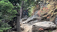
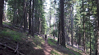
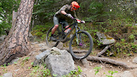
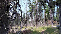
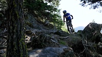
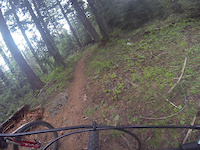
Photos of Parkdale Mountain Bike
Videos of Parkdale Mountain Bike
trail: Dog River Trail #675
0:17 |
1329 |
Oct 5, 2018
trail: Eightmile Loop Trail #496
3:15 |
603 |
Jul 28, 2018
trail: Dog River Trail #675
2:38 |
581 |
Jun 24, 2018
trail: Cooks Meadow Trail #639
4:36 |
387 |
Mar 1, 2018
trail: Dog River Trail #675
2:22 |
397 |
Jun 12, 2017

trail: Dog River Trail #675
2:13 |
493 |
Aug 3, 2014
trail: Surveyor's Ridge Trail #688
4:47 |
1238 |
May 18, 2014
youtuber
![Bottle Prairie and Knebal Springs]()
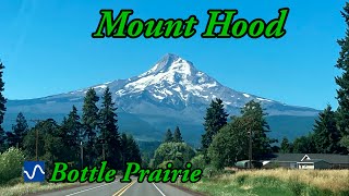
trail: Knebal Springs Trail #474
10:08 |
178 |
Aug 23, 2024 , Parkdale
Current Trail Warnings
| status | trail | date | condition | user | info |
|---|---|---|---|---|---|
| Pinemount Trail #300 | Jun 6, 2026 @ 10:18pm (America/Los_Angeles) Jun 6, 2026 | Unknown | Whiskeytownz | Dirtbike/Moto As of 06/05/2026 the trail was closed due... |
Recent Trail Reports
Activity Feed
| username | action | type | title | date |
|---|---|---|---|---|
| arwenu | wishlist | region | activity #97063582 | Jun 15, 2026 @ 1:48pm 2 days |
| JethroD | add | route | activity #97047408 | Jun 15, 2026 @ 9:36am 2 days |
| StevenwyMZrG | add | report | activity #97018927 and 1 more | Jun 14, 2026 @ 7:13pm Jun 14, 2026 |
| AlainL | wishlist | trail | activity #96992314 and 2 more | Jun 14, 2026 @ 11:54am Jun 14, 2026 |
| HRkiter | wishlist | region | activity #96967244 | Jun 14, 2026 @ 7:38am Jun 14, 2026 |
Recent Comments
| username | type | title | comment | date |
|---|---|---|---|---|
| trail | Trail is riding good, be prepared for some... | Jun 11, 2026 @ 4:49pm Jun 11, 2026 | ||
| trail | Trails clear and riding good. | Jun 11, 2026 @ 4:48pm Jun 11, 2026 | ||
| trail | Trail is clear of trees, some brushy spots but... | Jun 11, 2026 @ 4:48pm Jun 11, 2026 | ||
| trail | Pretty good descend, lots of switchbacks.... | Jun 11, 2026 @ 4:47pm Jun 11, 2026 | ||
| trail | Trails open and clear. Riding great this early. | Jun 11, 2026 @ 4:46pm Jun 11, 2026 |
Local Badges
-

10 Blue Trails4 awarded -

Epic Mountain Bike Climb 2k8 awarded -

Climbing 10k Badge0 awarded -

Mountain Biking 100k Badge0 awarded -

Epic Ride Descent 2k8 awarded -

Descent 10k Badge0 awarded
Activity Type Stats
| activitytype | trails | distance | descent | descent distance | total vertical | rating | global rank | state rank | photos | reports | routes | ridelogs |
|---|---|---|---|---|---|---|---|---|---|---|---|---|
| Mountain Bike | 47 | 133 miles | 29,954 ft | 73 miles | 4,281 ft | #1,707 | #632 | 625 | 1,126 | 16 | 7,804 | |
| E-Bike | 8 | 19 miles | 1,995 ft | 5 miles | 3,025 ft | #5,503 | #1,706 | 617 | 189 | |||
| Horse | 5 | 21 miles | 2,746 ft | 9 miles | 2,887 ft | #1,557 | #909 | 230 | 6 | |||
| Hike | 49 | 147 miles | 29,823 ft | 74 miles | 4,281 ft | #1,709 | #757 | 2 | 1,132 | 1 | 1,013 | |
| Trail Running | 49 | 147 miles | 29,823 ft | 74 miles | 4,281 ft | #1,324 | #478 | 1,132 | 3 | 225 | ||
| Dirtbike/Moto | 3 | 3 miles | 1,585 ft | 3 miles | 1,522 ft | #1,046 | #406 | 201 | 52 | |||
| ATV/ORV/OHV | 1 | 3 miles | 1,585 ft | 3 miles | 1,522 ft | #982 | #458 | 199 | 1 |
Frequently Asked Questions About Parkdale
▼
What are the best places to ride in Parkdale?
Parkdale has 2 areas to explore for mountain biking. The top rated areas are:
▼
What are the highest rated mountain biking trails in Parkdale?
The highest rated mountain biking trails in Parkdale are:
- Lookout Mountain Trail #450 (4.4/5)
- Boulder Lake Trail (4.3/5)
- Fifteenmile Trail #456 (4.3/5)
- Bottle Prairie Trail #455 (4.2/5)
- Surveyor's Ridge Trail #688 (4.1/5)
▼
What is the best time of the year to ride in Parkdale?
Based on ride log data, the most popular months to ride in Parkdale are:
- July (317 activities)
- August (239 activities)
- June (232 activities)
▼
Where can I park to ride in Parkdale?
There are 12 parking locations listed in Parkdale. The most popular parking spots are: View all parking and trailhead locations on the map to plan your visit.
Activities
Trails
- By rwgil370 & contributors
- Admins: NWTA
- #10524 - 3,189 views
- parkdale activity log | embed map of Parkdale mountain bike trails | parkdale mountain biking points of interest
Downloading of trail gps tracks in kml & gpx formats is enabled for Parkdale.
You must login to download files.