close
-
Layers w
- Weather Layers
- Pro
- Pro
- Pro
- Pro
- Pro
- Pro
- More Layers
- Pro
- Pro
- Pro
- Pro
-
Upgrade to

3D
Trail Conditions
- Unknown
- Snow Groomed
- Snow Packed
- Snow Covered
- Snow Cover Partial
- Freeze/thaw Cycle
- Icy
- Prevalent Mud
- Wet
- Variable
- Ideal
- Dry
- Very Dry
Trail Flow (Ridden Direction)
Trailforks scans users ridelogs to determine the most popular direction each trail is ridden. A good flowing trail network will have most trails flowing in a single direction according to their intension.
The colour categories are based on what percentage of riders are riding a trail in its intended direction.
The colour categories are based on what percentage of riders are riding a trail in its intended direction.
- > 96%
- > 90%
- > 80%
- > 70%
- > 50%
- < 50%
- bi-directional trail
- no data
Trail Last Ridden
Trailforks scans ridelogs to determine the last time a trail was ridden.
- < 2 days
- < 1 week
- < 2 weeks
- < 1 month
- < 6 months
- > 6 months
Trail Ridden Direction
The intended direction a trail should be ridden.
- Downhill Only
- Downhill Primary
- Both Directions
- Uphill Primary
- Uphill Only
- One Direction
Contribute Details
Colors indicate trail is missing specified detail.
- Description
- Photos
- Description & Photos
- Videos
Trail Popularity ?
Trailforks scans ridelogs to determine which trails are ridden the most in the last 9 months.
Trails are compared with nearby trails in the same city region with a possible 25 colour shades.
Think of this as a heatmap, more rides = more kinetic energy = warmer colors.
- most popular
- popular
- less popular
- not popular
ATV/ORV/OHV Filter
Max Vehicle Width
inches
US Cell Coverage
Legend

Radar Time
Activity Recordings
Trailforks uses anonymized public activity data.
?
Activity Recordings
Trailforks uses anonymized public activity data.
?
Personal Heatmap
▶
Activity Types
all
/
none
▶
Options
2
Date range
month
–
Winter Trails
Warning
A routing network for winter maps does not exist. Selecting trails using the winter trails layer has been disabled.
Missing Trails
Most Popular
Least Popular
Trails are colored based on popularity. The more popular a trail is, the more red. Less popular trails trend towards green.
Jump Magnitude Heatmap
Heatmap of where riders jump on trails. Zoom in to see individual jumps, click circles to view jump details.
BC Backroad Status
![map legend]()
Service Road Atlas is a free to use, community-driven service for viewing and creating reports on the numerous back-country service roads around B.C. and Alberta.

Slope Aspect
Direction the slope faces
Trails Deemphasized
Trails are shown in grey.
Only show trails with no bike usage.
Suggested Layers
Based on selected activity type
Save the current map location and zoom level as your default home location whenever this page is loaded.
Save
No description for Parksville has been added yet!
Login or register to submit one.
Activities Click to view
- Mountain Bike
203 trails
- E-Bike
180 trails
- Gravel Bike
1 trails
- Adaptive Bike
0 trails
- Winter Fat Bike
0 trails
- Hike
218 trails
- Trail Running
218 trails
Region Details
- 49
- 5
- 35
- 58
- 33
- 5
Region Status
Open as of 3 daysStats
- Avg Trail Rating
- Trails (view details)
- 190
- Trails Mountain Bike
- 219
- Trails E-Bike
- 180
- Trails Gravel Bike
- 1
- Trails Horse
- 2
- Trails Hike
- 218
- Trails Trail Running
- 218
- Trails Dirtbike/Moto
- 3
- Total Distance
- 82 miles
- Total Descent
- 17,063 ft
- Total Vertical
- 2,129 ft
- Highest Trailhead
- 2,146 ft
- Reports
- 5,001
- Photos
- 1,475
- Ridden Counter
- 96,506
Sub Regions
-
HammerFest
- 19
- 34
- 29
- 3
-
Little Mountain
- 4
- 16
- 2
- 2
-
Top Bridge/Englishman River Regional Park
- 8
- 6
- 1
Popular Parksville Mountain Biking Trails
• 100 ★ 3.9 • 2,467 ft • 0 ft • 2,520 •
Combine this with to start an easy climb to other lower HammerFest trails. The last section in the whole trail network.
• 85 ★ 4.4 • 1,224 ft • 9 ft • 1,650 •
The under the powerlines portion of . Fast and flowy!
• 100 ★ 3.9 • 476 ft • 4 ft • 1,557 •
Steep section that has the most elevation on the whole trail. Use for the climb.
• 95 ★ 4.6 • 1,775 ft • 19 ft • 1,447 •
A new, multi-use, access trail at Englishman River Falls Provincial Park. A family friendly route connecting the lower 'Little Dipper' to the 'Big Dipper' trail loops. Also provides a connection to the adjacent mountain bike trail...
• 100 ★ 4.7 • 548 ft • 102 ft • 1,432 •
Fun twisty, turny section of Temple of the Dog. Crosses the road under the powerlines and gives access to , and more.
• 95 ★ 4.7 • 1,033 ft • 112 ft • 1,383 •
Starts from a road landing known as the Saloon. Fun little trail that connects down to some of the more popular trails at HF.
• 95 ★ 4.9 • 1,158 ft • 75 ft • 1,373 •
Phase 2 portion of the trail in the Englishman River Falls Park. A family friendly final climb up to the ' '. Also with a connection to the adjacent mountain bike trail network at HammerFest. Being machine built, trail is wide enough...
Parksville Mountain Bike Routes
★ 4.0 • 5 miles • 880 ft • 14 • Loop •
Pretty much a bit of everything in this loop. Located primarily in the lower portions of HammerFest so...
★ 3.0 • 20 miles • 3,602 ft • 39 •
BCBR 2026 Stage 4 at Hammerfest, a brand new stage location located near Parksville, BC. Racers are going...
3 miles • 377 ft • 11 • Loop •
May Contest time! This is a special YOUTH ONLY loop. Youth riders are more then welcome to drag their...
5 miles • 838 ft • 10 • Loop •
Classic HammerFest loop, great for beginner to intermediate riders. Takes about an hour, has some roots on...
★ 2.0 • 8 miles • 1,264 ft • 11 • Loop •
Two laps up to the powerlines to make a 13km Loop riding two of the best trails on the lower mountain....
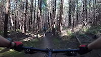
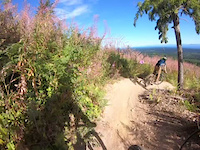
Photos of Parksville Mountain Bike
Videos of Parksville Mountain Bike
trail: Jughead
0:13 |
467 |
Dec 5, 2021
trail: Dirt Farm
0:32 |
622 |
Aug 12, 2021

trail: Scooby-Doo
6:24 |
321 |
Mar 12, 2021

trail: Jughead
7:51 |
279 |
Mar 12, 2021
trail: Cranky
0:10 |
116 |
Oct 5, 2020
trail: Free Fall
0:11 |
188 |
Jun 28, 2020
trail: Tomcat
0:11 |
326 |
May 6, 2020

trail: D Line
2:26 |
6629 |
Jan 7, 2020
Current Trail Warnings
| status | trail | date | condition | user | info |
|---|---|---|---|---|---|
| Insurrection | Jun 28, 2026 @ 8:55am (America/Vancouver) Jun 28, 2026 | Dry | rapid-roy TrailsBC | Logging continuing towards the south end,... | |
| Free Fall | Jun 14, 2026 @ 12:31pm (America/Vancouver) Jun 14, 2026 | Unknown | adfam ACC | Sign up closed for logging about half way... |
Recent Trail Reports
Activity Feed
| username | action | type | title | date |
|---|---|---|---|---|
| DGB80 | add | report | activity #98097472 | Jun 29, 2026 @ 5:29pm 3 days |
| rapid-roy | add | report | activity #98040485 and 3 more | Jun 28, 2026 @ 7:13pm Jun 28, 2026 |
| Skellett | vote | route | activity #97990660 and 1 more | Jun 28, 2026 @ 8:08am Jun 28, 2026 |
| ipfreely2 | vote | trail | activity #97930992 | Jun 27, 2026 @ 1:03pm Jun 27, 2026 |
| BoschSucks | add | report | activity #97905447 and 1 more | Jun 27, 2026 @ 8:18am Jun 27, 2026 |
Recent Comments
| username | type | title | comment | date |
|---|---|---|---|---|
| trail | Really fun track with some legit steep... | Jun 15, 2026 @ 4:37pm Jun 15, 2026 | ||
| report | Hard to imagine that Insurrection would be at... | Jun 14, 2026 @ 1:27pm Jun 14, 2026 | ||
| report | Mmm x w..!.@ xx dam z .: z, ez Z. Cm M x mx s... | Jun 11, 2026 @ 7:24pm Jun 11, 2026 | ||
| trail | One of the best climb trails on the island.... | May 24, 2026 @ 7:45pm May 24, 2026 | ||
| report | Rode through the logged sections today. Super... | May 16, 2026 @ 8:01pm May 16, 2026 |
Local Badges
-

10 Green Trails541 awarded -

10 Blue Trails1,179 awarded -

10 Black Trails260 awarded -

Epic Ride Climb 2k8 awarded -

Climbing 10k Badge104 awarded -

Climbing 100k Badge11 awarded
Bike & Skill Parks
| name | type | city | rating |
|---|---|---|---|
| Kids Pump Track | skill park | Parksville |
Local Mountain Biking Directory
-
Arrowsmith Cycling ClubClub
![Arrowsmith Cycling Club]()
-
Arrowsmith Bikes PBike Shop
![Arrowsmith Bikes P]()
-
Island CycleBike Shop
Activity Type Stats
| activitytype | trails | distance | descent | descent distance | total vertical | rating | global rank | state rank | photos | reports | routes | ridelogs |
|---|---|---|---|---|---|---|---|---|---|---|---|---|
| Mountain Bike | 203 | 80 miles | 16,778 ft | 36 miles | 2,129 ft | #224 | #27 | 1,459 | 5,034 | 28 | 34,055 | |
| E-Bike | 180 | 69 miles | 15,220 ft | 32 miles | 2,129 ft | #1,023 | #41 | 7 | 4,654 | 6 | 1,613 | |
| Gravel Bike | 1 | #421 | #96 | 1 | 7 | 115 | ||||||
| Horse | 2 | 3 miles | 325 ft | 1 mile | 407 ft | 586 | 7 | |||||
| Hike | 218 | 80 miles | 15,453 ft | 35 miles | 2,129 ft | #1,592 | #67 | 4 | 4,898 | 2 | 1,716 | |
| Trail Running | 218 | 80 miles | 15,453 ft | 35 miles | 2,129 ft | #1,181 | #47 | 6 | 4,897 | 4 | 1,689 | |
| Dirtbike/Moto | 3 | 593 | 79 |
Frequently Asked Questions About Parksville
▼
What are the best places to ride in Parksville?
Parksville has 3 areas to explore for mountain biking. The top rated areas are:
▼
What are the highest rated mountain biking trails in Parksville?
The highest rated mountain biking trails in Parksville are:
- Tomcat (4.6/5)
- Barefoot (4.5/5)
- Milky Way (4.5/5)
- DUI (4.4/5)
- Scooby-Doo (4.4/5)
▼
What is the best time of the year to ride in Parksville?
Based on ride log data, the most popular months to ride in Parksville are:
- July (790 activities)
- August (695 activities)
- May (637 activities)
▼
Where can I park to ride in Parksville?
There are 5 parking locations listed in Parksville. The most popular parking spots are: View all parking and trailhead locations on the map to plan your visit.
Activities
Trails
- parksville activity log | embed map of Parksville mountain bike trails | parksville mountain biking points of interest polygons
Downloading of trail gps tracks in kml & gpx formats is enabled for Parksville.
You must login to download files.