close
-
Layers w
- Weather Layers
- Pro
- Pro
- Pro
- Pro
- Pro
- Pro
- More Layers
- Pro
- Pro
- Pro
- Pro
-
Upgrade to

3D
Trail Conditions
- Unknown
- Snow Groomed
- Snow Packed
- Snow Covered
- Snow Cover Partial
- Freeze/thaw Cycle
- Icy
- Prevalent Mud
- Wet
- Variable
- Ideal
- Dry
- Very Dry
Trail Flow (Ridden Direction)
Trailforks scans users ridelogs to determine the most popular direction each trail is ridden. A good flowing trail network will have most trails flowing in a single direction according to their intension.
The colour categories are based on what percentage of riders are riding a trail in its intended direction.
The colour categories are based on what percentage of riders are riding a trail in its intended direction.
- > 96%
- > 90%
- > 80%
- > 70%
- > 50%
- < 50%
- bi-directional trail
- no data
Trail Last Ridden
Trailforks scans ridelogs to determine the last time a trail was ridden.
- < 2 days
- < 1 week
- < 2 weeks
- < 1 month
- < 6 months
- > 6 months
Trail Ridden Direction
The intended direction a trail should be ridden.
- Downhill Only
- Downhill Primary
- Both Directions
- Uphill Primary
- Uphill Only
- One Direction
Contribute Details
Colors indicate trail is missing specified detail.
- Description
- Photos
- Description & Photos
- Videos
Trail Popularity ?
Trailforks scans ridelogs to determine which trails are ridden the most in the last 9 months.
Trails are compared with nearby trails in the same city region with a possible 25 colour shades.
Think of this as a heatmap, more rides = more kinetic energy = warmer colors.
- most popular
- popular
- less popular
- not popular
ATV/ORV/OHV Filter
Max Vehicle Width
inches
US Cell Coverage
Legend

Radar Time
Activity Recordings
Trailforks uses anonymized public activity data.
?
Activity Recordings
Trailforks uses anonymized public activity data.
?
Personal Heatmap
▶
Activity Types
all
/
none
▶
Options
2
Date range
month
–
Winter Trails
Warning
A routing network for winter maps does not exist. Selecting trails using the winter trails layer has been disabled.
Missing Trails
Most Popular
Least Popular
Trails are colored based on popularity. The more popular a trail is, the more red. Less popular trails trend towards green.
Jump Magnitude Heatmap
Heatmap of where riders jump on trails. Zoom in to see individual jumps, click circles to view jump details.
BC Backroad Status
![map legend]()
Service Road Atlas is a free to use, community-driven service for viewing and creating reports on the numerous back-country service roads around B.C. and Alberta.

Slope Aspect
Direction the slope faces
Trails Deemphasized
Trails are shown in grey.
Only show trails with no bike usage.
Suggested Layers
Based on selected activity type
Save the current map location and zoom level as your default home location whenever this page is loaded.
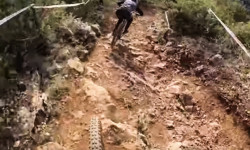
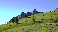
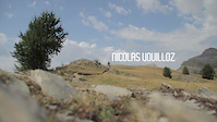
SaveThe iconic birthplace of Nicolas Vouilloz, Fabien Barel, Yoann Barelli and Nicolas Fillipi. Riding here gives an insight into how these top racers accumulated 14 UCI World Championships between them.
Primary Trail Type: All-Mountain & Downhill
eBikes Allowed:
Yes
Shuttleable: YES
This region uses the Uk/Euro style trail grading system.
Activities Click to view
- Mountain Bike
22 trails
- E-Bike
21 trails
- Adaptive Bike
0 trails
- Hike
22 trails
- Trail Running
22 trails
Region Details
- 1
- 3
- 12
- 4
- 2
Region Status
Open as of Jun 1, 2026Stats
- Avg Trail Rating
- Trails (view details)
- 22
- Trails Mountain Bike
- 22
- Trails E-Bike
- 21
- Trails Hike
- 22
- Trails Trail Running
- 22
- Total Distance
- 20 miles
- Total Descent
- 12,245 ft
- Total Vertical
- 2,913 ft
- Highest Trailhead
- 3,536 ft
- Reports
- 48
- Photos
- 34
- Ridden Counter
- 829
Articles
Video: Double Rainbow Ride with World Champs Vali Höll & Myriam Nicole
Feb 11, 2020 from pinkbike.com
The two World Champions ride the rocky Peille DH track in France.
Sub Regions
-
Peille
- 1
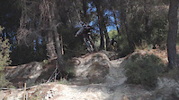
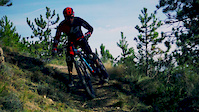
Popular Peille Mountain Biking Trails
• 85 ★ 3.0 • 5,254 ft • 151 ft • 41 •
It starts wide and fast +1m wide loose gravel trail and in the end you can choose different options or bailout (you can do a family or CX ride until this point). End is little steeper and there are many lines to choose from even some drops.
• 65 ★ 4.7 • 4,203 ft • 99 ft • 35 •
Moderately popular blue difficulty singletrack. This mountain bike primary trail can be used downhill only and has a moderate overall physical rating. On average it takes 9 minutes to complete this trail.
• 70 ★ 3.0 • 2 miles • 152 ft • 34 •
Exposed start with a mountain-top view of Nice and the méditerranéen sea, drops into a fast toboggan of a trail.
• 95 ★ 1.5 • 2 miles • 541 ft • 33 •
Popular blue difficulty singletrack. This mountain bike primary trail can be used downhill primary. On average it takes 25 minutes to complete this trail.
• 55 ★ 3.0 • 1 mile • 164 ft • 29 •
Technical trail: tight switch backs, obstacle to jump up, sharp loose rocks, narrow hill side trail etc. Downhill / enduro trail but rideable also on 29er.
• 50 ★ 0.0 • 2,021 ft • 114 ft • 25 •
Moderately popular red difficulty singletrack. This mountain bike primary trail can be used both directions and has a hard overall physical rating with a 114 ft black diamond climb. It features rock garden. Trail visibility is always easy to follow. On average it takes 16 minutes to complete this trail.
Peille Mountain Bike Routes
★ 4.0 • 13 miles • 3,294 ft • 2 • Loop •
The Rando des Champions is a non-profit event organised by Nicolas , Kieran Page and the commune of...
17 miles • 4,180 ft • 1 • Race •
The first International e-Bike Enduro circuit. Physically very demanding and finishes with the " ". The...
Photos of Peille Mountain Bike
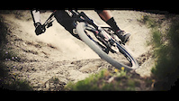
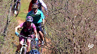
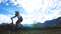
Videos of Peille Mountain Bike
trail: Vouilloz
2:37 |
565 |
Jan 29, 2016
trail: Vouilloz
2:24 |
11360 |
Jan 4, 2016
trail: Vouilloz
2:59 |
142 |
Dec 28, 2015
trail: Vouilloz
2:59 |
104 |
Dec 28, 2015
trail: Vouilloz
3:28 |
12381 |
Jul 23, 2015

trail: Vouilloz
2:33 |
7979 |
Apr 18, 2014
trail: Vouilloz
4:31 |
13571 |
May 24, 2013
trail: Vouilloz
3:07 |
28093 |
Feb 13, 2013
Recent Trail Reports
| status | trail | date | condition | info | user |
|---|---|---|---|---|---|
| Post du guet | May 17, 2026 @ 5:43pm (Europe/Paris) May 17, 2026 | Ideal | ika-rus | ||
| Mont Agel Section 2 | Dec 14, 2025 @ 9:33am (Europe/Monaco) Dec 14, 2025 | Ideal | smallboss | ||
| From Mont Agel trail down to the cement road of "Col de la Coupiere" | Oct 11, 2025 @ 10:01am (Europe/Monaco) Oct 11, 2025 | Dry | KonstantinosSkl | ||
| Kiki Land | Mar 29, 2024 @ 5:40am Mar 29, 2024 | Wet | i9801YW1 | ||
| Balcon de Peille Lower | Mar 29, 2024 @ 5:40am Mar 29, 2024 | Variable | i9801YW1 | ||
| Balcon de Peille Upper | Mar 29, 2024 @ 5:40am Mar 29, 2024 | Wet | i9801YW1 | ||
| Chemin de la Madone DH | Sep 22, 2023 @ 7:06am Sep 22, 2023 | Ideal | Alexair06 | ||
| Chemin du Rastel DH | Sep 22, 2023 @ 7:06am Sep 22, 2023 | Ideal | Alexair06 | ||
| MC Golf Deviation DH | Sep 5, 2023 @ 3:06pm Sep 5, 2023 | Dry | julien17 | ||
| Vouilloz | May 6, 2022 @ 5:49am May 6, 2022 | Ideal | bartekb |
Activity Feed
| username | action | type | title | date |
|---|---|---|---|---|
| Tarentule06 | wishlist | route | activity #95579025 | May 26, 2026 @ 11:31am May 26, 2026 |
| ika-rus | comment | report | activity #94907864 | May 17, 2026 @ 8:43am May 17, 2026 |
| ika-rus | add | report | activity #94907797 | May 17, 2026 @ 8:43am May 17, 2026 |
| ika-rus | add | photo | activity #94907482 and 2 more | May 17, 2026 @ 8:40am May 17, 2026 |
| Tarentule06 | wishlist | trail | activity #94085134 | May 5, 2026 @ 6:10am May 5, 2026 |
Recent Comments
| username | type | title | comment | date |
|---|---|---|---|---|
| report | All clear | May 17, 2026 @ 8:43am May 17, 2026 | ||
| trail | Starts off with a small climb. Most of the... | Dec 13, 2025 @ 8:21am Dec 13, 2025 | ||
| trail | Great trail with flow and few technical sections | Dec 13, 2025 @ 8:16am Dec 13, 2025 | ||
| trail | Done from Cotton Wool downwards…fantastic... | Sep 28, 2025 @ 8:14am Sep 28, 2025 | ||
| trail | Not good and dangerous | Jul 24, 2024 @ 8:06am Jul 24, 2024 |
Local Badges
-

Epic Ride Climb 2k71 awarded -

Climbing 10k Badge11 awarded -

Climbing 100k Badge0 awarded -

Epic Ride Descent 2k71 awarded -

Descent 10k Badge11 awarded -

Descent 100k Badge0 awarded
Bike & Skill Parks
| name | type | city | rating |
|---|---|---|---|
| Stade Saint Bernard | skill park | Peille |
Activity Type Stats
| activitytype | trails | distance | descent | descent distance | total vertical | rating | global rank | state rank | photos | reports | routes | ridelogs |
|---|---|---|---|---|---|---|---|---|---|---|---|---|
| Mountain Bike | 22 | 20 miles | 12,244 ft | 14 miles | 2,913 ft | #5,567 | #212 | 33 | 48 | 2 | 913 | |
| E-Bike | 21 | 19 miles | 11,499 ft | 13 miles | 2,913 ft | #3,128 | #180 | 47 | 4 | 1,044 | ||
| Hike | 22 | 20 miles | 12,244 ft | 14 miles | 2,913 ft | #5,189 | #168 | 1 | 48 | 1 | 95 | |
| Trail Running | 22 | 20 miles | 12,244 ft | 14 miles | 2,913 ft | #4,605 | #164 | 48 | 1 | 39 |
Frequently Asked Questions About Peille
▼
What are the best places to ride in Peille?
Peille has 1 areas to explore for mountain biking. The top rated areas are:
▼
What are the highest rated mountain biking trails in Peille?
The highest rated mountain biking trails in Peille are:
- Chataigniers Lower (4.2/5)
- Kiki Land (4/5)
- Vouilloz (4/5)
- Chemin de la Madone DH (3.8/5)
- Chemin du Rastel DH (3.8/5)
▼
What is the best time of the year to ride in Peille?
Based on ride log data, the most popular months to ride in Peille are:
- September (3 activities)
- October (2 activities)
- December (2 activities)
▼
Where can I park to ride in Peille?
Check the Peille trail map for trailhead and parking information. Community members regularly update access and parking details for trails in the area.
Activities
Trails
Points of Interest
- By hpman83
 TRAILFORKS TFFRANCE & contributors
 - Admins: apply
- #15248 - 6,740 views
- peille activity log | embed map of Peille mountain bike trails |
Downloading of trail gps tracks in kml & gpx formats is enabled for Peille.
You must login to download files.