close
-
Layers w
- Weather Layers
- Pro
- Pro
- Pro
- Pro
- Pro
- Pro
- More Layers
- Pro
- Pro
- Pro
- Pro
-
Upgrade to

3D
Trail Conditions
- Unknown
- Snow Groomed
- Snow Packed
- Snow Covered
- Snow Cover Partial
- Freeze/thaw Cycle
- Icy
- Prevalent Mud
- Wet
- Variable
- Ideal
- Dry
- Very Dry
Trail Flow (Ridden Direction)
Trailforks scans users ridelogs to determine the most popular direction each trail is ridden. A good flowing trail network will have most trails flowing in a single direction according to their intension.
The colour categories are based on what percentage of riders are riding a trail in its intended direction.
The colour categories are based on what percentage of riders are riding a trail in its intended direction.
- > 96%
- > 90%
- > 80%
- > 70%
- > 50%
- < 50%
- bi-directional trail
- no data
Trail Last Ridden
Trailforks scans ridelogs to determine the last time a trail was ridden.
- < 2 days
- < 1 week
- < 2 weeks
- < 1 month
- < 6 months
- > 6 months
Trail Ridden Direction
The intended direction a trail should be ridden.
- Downhill Only
- Downhill Primary
- Both Directions
- Uphill Primary
- Uphill Only
- One Direction
Contribute Details
Colors indicate trail is missing specified detail.
- Description
- Photos
- Description & Photos
- Videos
Trail Popularity ?
Trailforks scans ridelogs to determine which trails are ridden the most in the last 9 months.
Trails are compared with nearby trails in the same city region with a possible 25 colour shades.
Think of this as a heatmap, more rides = more kinetic energy = warmer colors.
- most popular
- popular
- less popular
- not popular
ATV/ORV/OHV Filter
Max Vehicle Width
inches
US Cell Coverage
Legend

Radar Time
Activity Recordings
Trailforks uses anonymized public activity data.
?
Activity Recordings
Trailforks uses anonymized public activity data.
?
Personal Heatmap
▶
Activity Types
all
/
none
▶
Options
2
Date range
month
–
Winter Trails
Warning
A routing network for winter maps does not exist. Selecting trails using the winter trails layer has been disabled.
Missing Trails
Most Popular
Least Popular
Trails are colored based on popularity. The more popular a trail is, the more red. Less popular trails trend towards green.
Jump Magnitude Heatmap
Heatmap of where riders jump on trails. Zoom in to see individual jumps, click circles to view jump details.
BC Backroad Status
![map legend]()
Service Road Atlas is a free to use, community-driven service for viewing and creating reports on the numerous back-country service roads around B.C. and Alberta.

Slope Aspect
Direction the slope faces
Trails Deemphasized
Trails are shown in grey.
Only show trails with no bike usage.
Suggested Layers
Based on selected activity type
Save the current map location and zoom level as your default home location whenever this page is loaded.
SaveThe greater Peoria area is served by the Peoria Area Mountain Bike Association (PAMBA - link below). PAMBA is dedicated to the responsible use of the trails by bicyclists through a few simple concepts, the goal being open trails for bicyclists and more trails where they are appropriate.
PAMBA maintains a wide variety of trail systems in the greater Peoria area, all within a 10-mile radius of downtown Peoria, catering to mountain bikers of all abilities and skill levels. Our flagship trail areas are:
Black Partridge Park in Metamora, Woodford County
Farmdale Reservoir in East Peoria, Tazewell County
Dirksen Park in Marquette Heights, Tazewell County
Independence Park in Marquette Heights, Tazewell County
Fort Creve Coeur in Creve Coeur, Tazewell County
Kinsey in Peoria, Peoria County
Wildlife Prairie Park in Hanna City, Peoria County
Jubilee State park in Brimfield, Peoria County
source: PAMBA Website
Links
Activities Click to view
- Mountain Bike
36 trails
- E-Bike
35 trails
- Gravel Bike
0 trails
- Adaptive Bike
0 trails
- Winter Fat Bike
0 trails
- Hike
111 trails
- Trail Running
111 trails
Region Details
- 12
- 3
- 6
- 6
Region Status
Open as of May 25, 2026Stats
- Avg Trail Rating
- Trails (view details)
- 92
- Trails Mountain Bike
- 46
- Trails E-Bike
- 35
- Trails Hike
- 111
- Trails Trail Running
- 111
- Total Distance
- 64 miles
- Total Descent
- 5,721 ft
- Total Vertical
- 340 ft
- Highest Trailhead
- 794 ft
- Reports
- 3,918
- Photos
- 188
- Ridden Counter
- 23,164
Sub Regions
-
Greater Peoria YMCA
- 1
- 2
-
Kinsey Park
- 2
- 5
- 6
-
Lauterbach Park
-
Rock Island Trail
Popular Peoria Mountain Biking Trails
• 100 ★ 4.5 • 2,139 ft • 24 ft • 350 •
Popular green difficulty singletrack. This mountain bike primary trail can be used both directions and has a easy overall physical rating with a 24 ft green climb. On average it takes 2 minutes to complete this trail.
• 100 ★ 4.5 • 3,136 ft • 111 ft • 338 •
Highly rated popular green difficulty singletrack. This mountain bike primary trail can be used both directions and has a easy overall physical rating with a 111 ft green climb. On average it takes 4 minutes to complete this trail.
• 95 ★ 4.7 • 1,696 ft • 17 ft • 336 •
Munchkinland has been designed with 3-5 year olds in mind and is truly fun for all ages. It is a wide, easy, flat trail to get the beginners into mountain biking.
• 90 ★ 4.7 • 4,383 ft • 15 ft • 315 •
Munchkinland has been designed with 3-5 year olds in mind and is truly fun for all ages. It is a wide, easy, flat trail to get the beginners into mountain biking.
• 85 ★ 4.4 • 1 mile • 203 ft • 304 •
Flowy singletrack with a mostly downhill start. What goes down, must climb back up! Keep your eyes to the skies as you pass through the Haunted Forest. You never know when a Flying Monkey might swoop down on you!
• 80 ★ 4.5 • 1,552 ft • 17 ft • 299 •
Popular green difficulty singletrack. This mountain bike primary trail can be used both directions and has a easy overall physical rating. On average it takes 1 minutes to complete this trail.
• 95 ★ 4.3 • 4,514 ft • 105 ft • 284 •
Oz is a flowy trail with several bridges and dips, located in open woods at the far end of the park.
Peoria Mountain Bike Routes
Toto Loop Featured
★ 5.0 • 2 miles • 163 ft • 7 • Loop •
This is the beginner loop for Kinsey, one step in difficulty above Munchkinland.
★ 5.0 • 5 miles • 365 ft • 12 • Loop •
Route details (note that the list from Trail Forks is a little wonky, this is the correct order of the...
★ 5.0 • 8 miles • 682 ft • 13 •
The Mug-O-Dirt route has been updated for 2022 to include , the newest addition to the park! Start on and...
★ 5.0 • 11 miles • 872 ft • 21 • Loop •
***EDIT: THIS HAS BEEN CORRECTED***Note: In the trail list TF did something wonky. When finishing you will...
1 mile • 29 ft • 2 • Loop •
This is the easiest set of trails in the park. It was designed specifically for 3-5 year-olds and will...
5 miles • 365 ft • 12 • Loop •
Route details (note that the list from Trail Forks is a little wonky, this is the correct order of the...
Photos of Peoria Mountain Bike
Videos of Peoria Mountain Bike
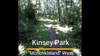
trail: Munchkinland (West)
0:40 |
58 |
Jul 8, 2025 , Peoria
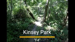
trail: F4
4:18 |
74 |
Jul 8, 2025 , Peoria
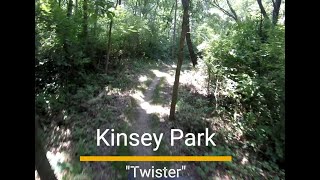
trail: Twister
0:17 |
91 |
Jul 8, 2025 , Peoria
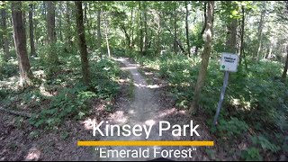
trail: Emerald Forest
3:28 |
71 |
Jul 8, 2025 , Peoria
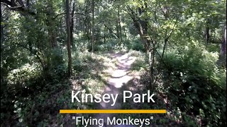
trail: Flying Monkeys
12:35 |
70 |
Jul 7, 2025 , Peoria
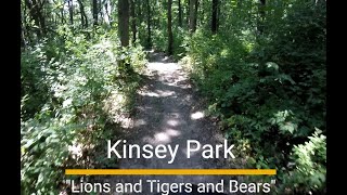
trail: Lions and Tigers and Bears
3:08 |
56 |
Jul 7, 2025 , Peoria
trail: Land of Oz
7:32 |
68 |
Jul 7, 2025 , Peoria
trail: Tinman
0:18 |
62 |
Jul 7, 2025 , Peoria
Recent Trail Reports
| status | trail | date | condition | info | user |
|---|---|---|---|---|---|
| Emerald Forest | May 25, 2026 @ 2:53pm (America/Chicago) May 25, 2026 | Ideal | cmace88 PAMBA | ||
| The Wizard | Dec 6, 2025 @ 2:13pm (America/Chicago) Dec 6, 2025 | Unknown | abroughton3 | ||
| Cowardly Lion | Oct 26, 2025 @ 10:28am (America/Chicago) Oct 26, 2025 | Ideal | cmace88 PAMBA | ||
| Lions and Tigers and Bears | Sep 12, 2025 @ 2:36pm (America/Chicago) Sep 12, 2025 | Unknown | abroughton3 | ||
| Land of Oz | Aug 18, 2025 @ 6:28pm Aug 18, 2025 | Variable | joshuay | ||
| F4 | Jul 11, 2025 @ 7:26am Jul 11, 2025 | Variable | sns1294 PAMBA | ||
| Flying Monkeys | Jul 10, 2025 @ 5:00am Jul 10, 2025 | Ideal | ChristiancvPoPZ | ||
| Munchkinland (West) | Jul 7, 2025 @ 10:29am Jul 7, 2025 | Ideal | ryechard | ||
| Twister | Jul 7, 2025 @ 10:29am Jul 7, 2025 | Dry | ryechard | ||
| Farm Road Extension (Far North) | Jul 7, 2025 @ 10:29am Jul 7, 2025 | Ideal | ryechard |
Activity Feed
| username | action | type | title | date |
|---|---|---|---|---|
| Anne5uY7 | wishlist | route | activity #96184059 | Jun 3, 2026 @ 3:24pm Jun 3, 2026 |
| Mokayaker | rsvp | event | activity #95903311 | May 30, 2026 @ 6:32pm May 30, 2026 |
| Rimbaud | vote | trail | activity #95807550 | May 29, 2026 @ 3:54pm May 29, 2026 |
| twardil | rsvp | event | activity #95624508 | May 27, 2026 @ 4:19am May 27, 2026 |
| cmace88 | add | report | activity #95515811 | May 25, 2026 @ 12:53pm May 25, 2026 |
Recent Comments
| username | type | title | comment | date |
|---|---|---|---|---|
| report | Tree down halfway into wizard | Mar 12, 2025 @ 1:25pm Mar 12, 2025 | ||
| report | Goofy app. You’re right. | Oct 30, 2024 @ 3:12pm Oct 30, 2024 | ||
| report | I don't think this is on the rock island trail | Oct 30, 2024 @ 1:17pm Oct 30, 2024 | ||
| trail | Nice flowy, machine built single track. Well... | Sep 1, 2024 @ 11:42am Sep 1, 2024 | ||
| report | K | Mar 3, 2024 @ 2:01pm Mar 3, 2024 |
Local Badges
-

Completionist4 awarded -

Big Ride 30k1,831 awarded -

Epic Ride 50k559 awarded -

Top 10 Trails37 awarded -
Completionist25 awarded -
Completionist96 awarded
Activity Type Stats
| activitytype | trails | distance | descent | descent distance | total vertical | rating | global rank | state rank | photos | reports | routes | ridelogs |
|---|---|---|---|---|---|---|---|---|---|---|---|---|
| Mountain Bike | 36 | 36 miles | 1,726 ft | 14 miles | 341 ft | #1,592 | #598 | 189 | 7,445 | 13 | 12,474 | |
| E-Bike | 35 | 2,959 ft | 20 ft | 1,178 ft | 36 ft | #6,265 | #1,906 | 469 | 1 | 214 | ||
| Hike | 111 | 64 miles | 5,722 ft | 25 miles | 341 ft | #3,601 | #1,267 | 2 | 3,901 | 1 | 607 | |
| Trail Running | 111 | 64 miles | 5,722 ft | 25 miles | 341 ft | #3,100 | #905 | 3,901 | 1 | 297 |
Frequently Asked Questions About Peoria
▼
What are the best places to ride in Peoria?
Peoria has 11 areas to explore for mountain biking. The top rated areas are:
▼
What are the highest rated mountain biking trails in Peoria?
The highest rated mountain biking trails in Peoria are:
- Lions and Tigers and Bears (4.2/5)
- Munchkinland (West) (4.2/5)
- Munchkinland (East) (4.2/5)
- Emerald Forest (4.2/5)
- Ruby Slippers (4.2/5)
▼
What is the best time of the year to ride in Peoria?
Based on ride log data, the most popular months to ride in Peoria are:
- July (142 activities)
- August (134 activities)
- September (125 activities)
▼
Where can I park to ride in Peoria?
Activities
Trails
- By Cdrobb122 & contributors
- Admins: PAMBA, PAMBA-Kinsey, PAMBA-BPP, PAMBA-WPP, PAMBA
- #4585 - 15,321 views
- peoria activity log | embed map of Peoria mountain bike trails | peoria mountain biking points of interest
Downloading of trail gps tracks in kml & gpx formats is enabled for Peoria.
You must login to download files.