close
-
Layers w
- Weather Layers
- Pro
- Pro
- Pro
- Pro
- Pro
- Pro
- More Layers
- Pro
- Pro
- Pro
- Pro
-
Upgrade to

3D
Trail Conditions
- Unknown
- Snow Groomed
- Snow Packed
- Snow Covered
- Snow Cover Partial
- Freeze/thaw Cycle
- Icy
- Prevalent Mud
- Wet
- Variable
- Ideal
- Dry
- Very Dry
Trail Flow (Ridden Direction)
Trailforks scans users ridelogs to determine the most popular direction each trail is ridden. A good flowing trail network will have most trails flowing in a single direction according to their intension.
The colour categories are based on what percentage of riders are riding a trail in its intended direction.
The colour categories are based on what percentage of riders are riding a trail in its intended direction.
- > 96%
- > 90%
- > 80%
- > 70%
- > 50%
- < 50%
- bi-directional trail
- no data
Trail Last Ridden
Trailforks scans ridelogs to determine the last time a trail was ridden.
- < 2 days
- < 1 week
- < 2 weeks
- < 1 month
- < 6 months
- > 6 months
Trail Ridden Direction
The intended direction a trail should be ridden.
- Downhill Only
- Downhill Primary
- Both Directions
- Uphill Primary
- Uphill Only
- One Direction
Contribute Details
Colors indicate trail is missing specified detail.
- Description
- Photos
- Description & Photos
- Videos
Trail Popularity ?
Trailforks scans ridelogs to determine which trails are ridden the most in the last 9 months.
Trails are compared with nearby trails in the same city region with a possible 25 colour shades.
Think of this as a heatmap, more rides = more kinetic energy = warmer colors.
- most popular
- popular
- less popular
- not popular
ATV/ORV/OHV Filter
Max Vehicle Width
inches
US Cell Coverage
Legend

Radar Time
Activity Recordings
Trailforks uses anonymized public activity data.
?
Activity Recordings
Trailforks uses anonymized public activity data.
?
Personal Heatmap
▶
Activity Types
all
/
none
▶
Options
2
Date range
month
–
Winter Trails
Warning
A routing network for winter maps does not exist. Selecting trails using the winter trails layer has been disabled.
Missing Trails
Most Popular
Least Popular
Trails are colored based on popularity. The more popular a trail is, the more red. Less popular trails trend towards green.
Jump Magnitude Heatmap
Heatmap of where riders jump on trails. Zoom in to see individual jumps, click circles to view jump details.
BC Backroad Status
![map legend]()
Service Road Atlas is a free to use, community-driven service for viewing and creating reports on the numerous back-country service roads around B.C. and Alberta.

Slope Aspect
Direction the slope faces
Trails Deemphasized
Trails are shown in grey.
Only show trails with no bike usage.
Suggested Layers
Based on selected activity type
Save the current map location and zoom level as your default home location whenever this page is loaded.
SavePopular Trail Networks
view all areas »
No description for Greater Perth Metropolitan Region (WA) has been added yet!
Login or register to submit one.
Activities Click to view
- Mountain Bike
648 trails
- E-Bike
572 trails
- Gravel Bike
175 trails
- Adaptive Bike
99 trails
- Winter Fat Bike
38 trails
- Horse
5 trails
- Hike
323 trails
- Trail Running
381 trails
- Dirtbike/Moto
1 trails
- ATV/ORV/OHV
0 trails
Region Details
- 113
- 18
- 89
- 227
- 159
- 42
Stats
- Avg Trail Rating
- Trails (view details)
- 734
- Trails Mountain Bike
- 648
- Trails E-Bike
- 572
- Trails Gravel Bike
- 175
- Trails Adaptive Bike
- 99
- Trails Winter Fat Bike
- 38
- Trails Horse
- 5
- Trails Hike
- 323
- Trails Trail Running
- 381
- Trails Dirtbike/Moto
- 1
- Total Distance
- 802 miles
- Total Descent
- 123,854 ft
- Total Vertical
- 1,866 ft
- Highest Trailhead
- 1,872 ft
- Reports
- 8,440
- Photos
- 1,222
- Ridden Counter
- 57,281
Sub Regions
- Byford (40)
- Byford Trails (40)
- Chidlow (30)
- Forsyth Mill (9)
- Lake Leschenaultia (12)
- City of Perth (30)
- Dwellingup (120)
- Fremantle (4)
- Booyeembara Park (4)
- Greenmount (25)
- Goat Farm (25)
- Hamilton Hill (59)
- Manning Park (59)
- Jarrahdale (12)
- Langford Park (10)
- Wetlands Park (1)
- Joondalup (12)
- Kalamunda (180)
- Kalamunda Trail Network (92)
- Orange Grove (14)
- Pickering Brook (12)
- The Valley (52)
- Kelmscott (20)
- John Dunne (5)
- Kelmscott Trails (10)
- Roleystone (5)
- Mundaring (30)
- Glen Forrest (21)
- Mundaring DH Trails (8)
- Swan View (37)
- Upper Swan (14)
- Bell's Rapids (14)
- Waroona (1)
- Wilson (1)
- Dyoondalup Point Walter Bike Park (8)
Popular Greater Perth Metropolitan Region (WA) Trails
• 100 ★ 3.8 • 1,322 ft • 0 ft • 1,669 •
This flow trail might be short but it packs a lot of fun in. Descending from the west side of the clearing at the top of Gunjin it takes you to the start of or Three Bears.
• 100 ★ 2.0 • 410 ft • 18 ft • 1,601 •
Popular green difficulty singletrack. This mountain bike primary trail can be used downhill only and has a easy overall physical rating with a 18 ft green climb. On average it takes minutes to complete this trail.
• 100 ★ 3.6 • 1,220 ft • 82 ft • 1,581 •
Like Dolph Lundgren's character, Ivan , in Rocky III this climb is not as hard as . In fact its a simple non technical climb for those who want to cruise back to the top to do it all again. Continuing on from it merges with Rocky near...
• 100 ★ 4.5 • 1 mile • 23 ft • 1,536 •
A fast flowing trail, marked with a pair of Devil's Horns (trees) at its start. The first few corners are a bit tight but it just gets faster and faster until eventually spitting you out at the Black Stump car park.
• 100 ★ 4.2 • 3,655 ft • 100 ft • 1,531 •
Joeys Line: This section of trail named after Canadian trail builder Joey Klein who ran a tail workshop here. A tricky rocky climb to get the legs warmed up. Dugite: A snaking trail with one small jump and lots of fast corners.
• 100 ★ 4.2 • 2,648 ft • 136 ft • 1,508 •
A twisty climb up through the pines which takes you gradually to the Dell. So gentle that it doesn't even feel like a hill.
Mountain Bike Routes
John Forrest Classic Featured
9 miles • 1,105 ft • 8 •
The original and one of the best. A great mix of technical climbing and descending with some amazing...
★ 3.5 • 13 miles • 1,250 ft • 35 •
The original loop that started it all, that has been added to much since it first opened in 2011. Most of...
★ 5.0 • 38 miles • 3,575 ft • 3 • Loop •
This is a great way to prepare for the Dwellingup 100 by seeing a major portion of the past years race...
★ 5.0 • 5 miles • 556 ft • 9 • Out & Back •
A perfect Out and Back run for those just starting off.
★ 4.0 • 13 miles • 1,236 ft • 38 • Loop •
A great loop with plenty of single track and fitness required. , FJ, and will provide plenty of fun...
Photos of Greater Perth Metropolitan Region (WA) Mountain Bike
Videos of Greater Perth Metropolitan Region (WA) Mountain Bike
trail: Shakes n Ladders
0:03 |
100 |
Oct 10, 2025
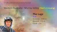
trail: The Luge
0:26 |
91 |
Jul 4, 2025
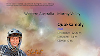
trail: Quokkamoly
4:55 |
56 |
Jan 25, 2025

trail: Busted Nuts
4:08 |
64 |
Jan 25, 2025

trail: Mayhem
5:59 |
66 |
Jan 25, 2025

trail: Devils Pass
4:47 |
44 |
Jan 25, 2025

trail: Slingshot
4:18 |
54 |
Jan 25, 2025
trail: The Luge
4:22 |
46 |
Jan 25, 2025
Current Trail Warnings
| status | trail | date | condition | user | info |
|---|---|---|---|---|---|
| Rocky-Drago Link Kalamunda Trail Network | Jun 8, 2026 @ 10:34am (Australia/Perth) Jun 7, 2026 | Variable | sweatytechie MTBWA | Trail decommissioned (blocked with many... | |
| Judderbars Kalamunda Trail Network | Jun 24, 2026 @ 12:28pm (Australia/Perth) Jun 23, 2026 | Ideal | sweatytechie MTBWA | Closed for trail rebuild | |
| Mother in Law Kalamunda Trail Network | Jun 21, 2026 @ 8:46am (Australia/Perth) Jun 20, 2026 | Ideal | shortcut-western-australia | E-Bike |
Recent Trail Reports
National Scenic Trails & Official Routes
-
Munda Biddi Trail
- Mountain Bike
- Hike
- Trail Running
Activity Feed
| username | action | type | title | date |
|---|---|---|---|---|
| sweatytechie | update | trail | activity #97923474 | Jun 27, 2026 @ 11:38am 1 day |
| sweatytechie | update | trail | activity #97922112 and 1 more | Jun 27, 2026 @ 11:23am 1 day |
| sweatytechie | update | trail | activity #97921651 | Jun 27, 2026 @ 11:18am 1 day |
| sweatytechie | update | region | activity #97921468 | Jun 27, 2026 @ 11:16am 1 day |
| sweatytechie | update | trail | activity #97920971 and 10 more | Jun 27, 2026 @ 11:12am 1 day |
Recent Comments
| username | type | title | comment | date |
|---|---|---|---|---|
| report | Open - No issue | Jun 7, 2026 @ 2:07am Jun 7, 2026 | ||
| trail | Fantastic new trail. The climb is pretty solid... | May 20, 2026 @ 10:28pm May 20, 2026 | ||
| trail | If you ride this trail be prepared as the hike... | Feb 13, 2026 @ 8:40pm Feb 13, 2026 | ||
| trail | Very fun easy trail love the drops even... | Jan 27, 2026 @ 5:45pm Jan 27, 2026 | ||
| report | What’s the deal with the last 2 table tops.. | Nov 18, 2025 @ 5:24pm Nov 18, 2025 |
Local Badges
-

Climbing 10k Badge517 awarded -

10 Green Trails551 awarded -

10 Expert Trails31 awarded -

Epic Mountain Bike Climb 2k828 awarded -
10 Green Trails69 awarded -

Mountain Biking 100k Badge82 awarded
Bike & Skill Parks
| name | type | city | rating |
|---|---|---|---|
| Kingsley Pump Track | skill park | ||
| Midland Pump Track & Skate Park | skill park | ||
| Dixon Park | skill park | Hamilton Hill | |
| Spearwood Pump track & Dirt Jumps | skill park | ||
| Forster Park Pump Track & Dirt Jumps | skill park |
Upcoming Local Events
Local Trail Supporters
- Single Track Minds
- Avanti Plus Cannington
- Discovery Holiday Parks
- Cambridge St. Associates
- Wembley Cycles
- Carine Cycles
![Australian Underground Drilling]()
- Camelbak
- Hillary's Boat and Tackle
- BankWest
- Castech
- Munda Biddi Bike Hire
![]()
- http://magicdirt.com.au/
- Samios Plumbing Supplies
- Xodus Group
- ToxFree
![]()
- Sea to Summit
Activity Type Stats
| activitytype | trails | distance | descent | descent distance | total vertical | rating | global rank | state rank | photos | reports | routes | ridelogs |
|---|---|---|---|---|---|---|---|---|---|---|---|---|
| Mountain Bike | 648 | 639 miles | 104,934 ft | 301 miles | 1,319 ft | #37 | #5 | 1,196 | 8,432 | 79 | 349,671 | |
| E-Bike | 572 | 578 miles | 95,390 ft | 273 miles | 1,319 ft | #61 | #28 | 14 | 7,551 | 16 | 20,217 | |
| Gravel Bike | 175 | 326 miles | 28,028 ft | 143 miles | 1,867 ft | #133 | 846 | 8 | 531 | |||
| Adaptive Bike | 99 | 156 miles | 10,666 ft | 64 miles | 1,299 ft | #201 | 767 | 4 | 2 | |||
| Winter Fat Bike | 38 | 26 miles | 1,772 ft | 9 miles | 1,007 ft | #112 | 425 | |||||
| Horse | 5 | 4 miles | 413 ft | 2 miles | 817 ft | #266 | #24 | 5 | 1,443 | 1 | 10 | |
| Hike | 323 | 452 miles | 43,451 ft | 196 miles | 1,867 ft | #346 | #15 | 7 | 7,710 | 3 | 5,194 | |
| Trail Running | 381 | 508 miles | 57,195 ft | 225 miles | 1,867 ft | #177 | #12 | 7,819 | 33 | 14,046 | ||
| Dirtbike/Moto | 1 | 3 miles | 331 ft | 1 mile | 217 ft | #204 | #9 | 1,354 | 182 |
Frequently Asked Questions About Greater Perth Metropolitan Region (WA)
▼
What are the best places to ride in Greater Perth Metropolitan Region (WA)?
Greater Perth Metropolitan Region (WA) has 33 areas to explore for mountain biking. The top rated areas are:
▼
What are the highest rated mountain biking trails in Greater Perth Metropolitan Region (WA)?
The highest rated mountain biking trails in Greater Perth Metropolitan Region (WA) are:
- Camakazi (4.5/5)
- Blaze (4.5/5)
- Skills Park (4.5/5)
- Mercury Street (4.5/5)
- Scorpion (4.4/5)
▼
What is the longest trail in Greater Perth Metropolitan Region (WA)?
The longest trail in Greater Perth Metropolitan Region (WA) is Kep Track at 37.5 miles. View all trails sorted by distance.
▼
What are the best & highest rated hiking trails in Greater Perth Metropolitan Region (WA)?
The best hiking trails in Greater Perth Metropolitan Region (WA) are: View all hiking trails sorted by popularity score.
Activities
- Greater Perth Metropolitan Region (WA) Mountain Biking Trails
- Greater Perth Metropolitan Region (WA) E-Biking Trails
- Greater Perth Metropolitan Region (WA) Gravel Biking Trails
- Greater Perth Metropolitan Region (WA) Adaptive Biking Trails
- Greater Perth Metropolitan Region (WA) Winter Fat Biking Trails
- Greater Perth Metropolitan Region (WA) Horseback Trails
- Greater Perth Metropolitan Region (WA) Hiking Trails
- Greater Perth Metropolitan Region (WA) Trail Running Trails
Trails
- Hard trails in Greater Perth Metropolitan Region (WA)
- Easy trails in Greater Perth Metropolitan Region (WA)
- Favorite trails in Greater Perth Metropolitan Region (WA)
- Most ridden trails in Greater Perth Metropolitan Region (WA)
- Singletrack in Greater Perth Metropolitan Region (WA)
- Viewpoint trails in Greater Perth Metropolitan Region (WA)
- Trails with technical features in Greater Perth Metropolitan Region (WA)
- Race routes in Greater Perth Metropolitan Region (WA)
Points of Interest
- DNA Tower Viewpoint
- Ocean View Lookout Viewpoint
- Balga Track Southern Lookout Viewpoint
- Right Berm TTF
- Drop TTF
- Trail Fork TTF
- Potential to cross rocks in summer to access trails TTF
- Reabold Hill Summit - 85m
- Western Lookout Viewpoint
- Mount Eliza Lookout Viewpoint
- Mount Singleton (2,011 ft)
- Mount Cooke (1,893 ft)
- Mount Wells (1,795 ft)
- By Wild75 & contributors
- Admins: Jake-Hannah, Addzz, MTBWA
- #52733 - 29,433 views
- greater perth metropolitan region (wa) activity log | embed map of Greater Perth Metropolitan Region (WA) mountain bike trails | greater perth metropolitan region (wa) mountain biking points of interest polygons
Downloading of trail gps tracks in kml & gpx formats is enabled for Greater Perth Metropolitan Region (WA).
You must login to download files.