close
-
Layers w
- Weather Layers
- Pro
- Pro
- Pro
- Pro
- Pro
- Pro
- More Layers
- Pro
- Pro
- Pro
- Pro
-
Upgrade to

3D
Trail Conditions
- Unknown
- Snow Groomed
- Snow Packed
- Snow Covered
- Snow Cover Partial
- Freeze/thaw Cycle
- Icy
- Prevalent Mud
- Wet
- Variable
- Ideal
- Dry
- Very Dry
Trail Flow (Ridden Direction)
Trailforks scans users ridelogs to determine the most popular direction each trail is ridden. A good flowing trail network will have most trails flowing in a single direction according to their intension.
The colour categories are based on what percentage of riders are riding a trail in its intended direction.
The colour categories are based on what percentage of riders are riding a trail in its intended direction.
- > 96%
- > 90%
- > 80%
- > 70%
- > 50%
- < 50%
- bi-directional trail
- no data
Trail Last Ridden
Trailforks scans ridelogs to determine the last time a trail was ridden.
- < 2 days
- < 1 week
- < 2 weeks
- < 1 month
- < 6 months
- > 6 months
Trail Ridden Direction
The intended direction a trail should be ridden.
- Downhill Only
- Downhill Primary
- Both Directions
- Uphill Primary
- Uphill Only
- One Direction
Contribute Details
Colors indicate trail is missing specified detail.
- Description
- Photos
- Description & Photos
- Videos
Trail Popularity ?
Trailforks scans ridelogs to determine which trails are ridden the most in the last 9 months.
Trails are compared with nearby trails in the same city region with a possible 25 colour shades.
Think of this as a heatmap, more rides = more kinetic energy = warmer colors.
- most popular
- popular
- less popular
- not popular
ATV/ORV/OHV Filter
Max Vehicle Width
inches
US Cell Coverage
Legend

Radar Time
Activity Recordings
Trailforks uses anonymized public activity data.
?
Activity Recordings
Trailforks uses anonymized public activity data.
?
Personal Heatmap
▶
Activity Types
all
/
none
▶
Options
2
Date range
month
–
Winter Trails
Warning
A routing network for winter maps does not exist. Selecting trails using the winter trails layer has been disabled.
Missing Trails
Most Popular
Least Popular
Trails are colored based on popularity. The more popular a trail is, the more red. Less popular trails trend towards green.
Jump Magnitude Heatmap
Heatmap of where riders jump on trails. Zoom in to see individual jumps, click circles to view jump details.
BC Backroad Status
![map legend]()
Service Road Atlas is a free to use, community-driven service for viewing and creating reports on the numerous back-country service roads around B.C. and Alberta.

Slope Aspect
Direction the slope faces
Trails Deemphasized
Trails are shown in grey.
Only show trails with no bike usage.
Suggested Layers
Based on selected activity type
Save the current map location and zoom level as your default home location whenever this page is loaded.
SavePopular Trail Networks
view all areas »
No description for Perth and Kinross Region has been added yet!
Login or register to submit one.
This region uses the Uk/Euro style trail grading system.
Activities Click to view
- Mountain Bike
872 trails
- E-Bike
782 trails
- Horse
101 trails
- Hike
623 trails
- Trail Running
622 trails
- Dirtbike/Moto
0 trails
- Observed Trials
0 trails
- ATV/ORV/OHV
0 trails
- Nordic Ski
0 trails
Region Details
- 278
- 104
- 149
- 152
- 144
- 8
Stats
- Avg Trail Rating
- Trails (view details)
- 836
- Trails Mountain Bike
- 877
- Trails E-Bike
- 782
- Trails Gravel Bike
- 1
- Trails Adaptive Bike
- 1
- Trails Winter Fat Bike
- 1
- Trails Horse
- 101
- Trails Hike
- 623
- Trails Trail Running
- 622
- Total Distance
- 570 miles
- Total Descent
- 122,646 ft
- Total Vertical
- 3,392 ft
- Highest Trailhead
- 3,472 ft
- Reports
- 6,090
- Photos
- 843
- Ridden Counter
- 163,057
Articles

Video: Winter Shredding at Glassie BikePark With Corey Watson
Feb 6, 2025 from pinkbike.com
Corey Watson sure knows how to ride a bike.
Video: Lachlan Blair's 61 Second Raw Edit on Glassie Bike Park's Shredo Trail
Jan 16, 2024 from pinkbike.com
Some perfect moody winter riding.
Video & Photo Story: The Best Hand Cut Trails in Scotland, Perthshire
Nov 18, 2021 from pinkbike.com
Scotty Laughland visits Perthshire and showcases the region's diversity through riding locations, Dunkeld, Comrie Croft and Aberfeldy.
Video: Joe Barnes & Hazzard Racing's Chippy Tour of Scotland Begins
Jun 29, 2021 from pinkbike.com
The loam of Inverness and the shale of Dunkeld is a match made in heaven for a trip on the road.
Sub Regions
- Aberargie (10)
- Aberfeldy (65)
- Glassie Bike Park (16)
- Strathtay & Grandtully Wood (19)
- Weem Wood (26)
- Alyth (33)
- Alyth Hill (30)
- Blair Atholl (7)
- Beinn Dearg (2)
- Glen Tilt (4)
- Braco (21)
- Bridge of Gaur (2)
- Comrie (38)
- Ben Chonzie (1)
- Comrie Croft (35)
- Coupar Angus (83)
- Ballo Wood (38)
- Hallyburton & Lundie Craigs (45)
- Crieff (68)
- Crieff Hydro Trails (27)
- Torlum Trails (26)
- Dunkeld (246)
- Atholl Hill (51)
- Birnam Hill (24)
- Craigvinean (53)
- Dalmarnock (67)
- Deuchary Hill (23)
- Newtyle Hill (10)
- Dunning (41)
- Littlerigg (15)
- Perth (138)
- Deuchny Woods (60)
- Kinnoull Hill (61)
- Moncreiffe Hill (17)
- Pitlochry (46)
- Auchnafree (5)
- Ben Vorlich (1)
- Dunsinane Hill (1)
- Glen Devon (47)
Popular Perth and Kinross Region Mountain Biking Trails
• 95 ★ 4.4 • 1,280 ft • 52 ft • 1,517 •
Highly rated popular blue difficulty singletrack. This mountain bike primary trail can be used one direction and has a moderate overall physical rating with a 52 ft blue climb. It features bridge. Trail visibility is always easy to follow. On average it takes 3 minutes to complete this trail.
• 95 ★ 4.7 • 3,179 ft • 42 ft • 1,466 •
The most obviously man made trail at Comrie. Starts at the cattle grid, or as a continuation of the blue upper. If your new, you can roll the whole thing, you might have to pedal a bit. Experienced riders will love the way the trail...
• 90 ★ 3.8 • 1,457 ft • 3 ft • 1,361 •
Outward from fireroad that leads to blue, red and black routes
• 100 ★ 4.0 • 295 ft • 12 ft • 1,293 •
Highly rated popular red difficulty singletrack. This mountain bike primary trail can be used one direction and has a moderate overall physical rating with a 12 ft black diamond climb. Trail visibility is always easy to follow. On average it takes minutes to complete this trail.
• 70 ★ 4.1 • 1,529 ft • 24 ft • 1,286 •
Small climb about halfway through. Little bit more technical than a standard Forestry Commission blue route. There area couple of extra sections with black grade sections too, so it's worth riding even if you'd normally skip blue routes.
• 85 ★ 4.2 • 1,975 ft • 0 ft • 1,223 •
Tight, rocky harsh trail with steep corners and tricky rocky obstacles. Little bit pedally at the top and bottom. This trail is nothing like any Forestry Commission red graded trail, or even the new red graded trail - it's far more...
• 90 ★ 4.5 • 689 ft • 0 ft • 1,196 •
Highly rated popular blue difficulty machine groomed. This mountain bike primary trail can be used one direction and has a easy overall physical rating with a 0 ft blue climb. It features berm. Trail visibility is always easy to follow. On average it takes 5 minutes to complete this trail.
• 65 ★ 4.3 • 2,392 ft • 23 ft • 1,161 •
Bridges, rocks, lots of extra optional sections as close to feeling natural as it gets at a trail centre.
Perth and Kinross Region Mountain Bike Routes
★ 1.0 • 183 miles • 10,595 ft • 1 • Loop •
The Cairngorms Loop is a 186 mile (300km) independent time trial (ITT) route through the Cairngorms...
5 miles • 448 ft • 1 •
The Classic Fiddlers Loop form Dunkeld. This crosses the A9 bridge on a footpath. Note the A9 works as a...
★ 3.0 • 22 miles • 1,874 ft • 1 • Loop •
Starting at Bankfoot, with a road section to warm up. Otherwise mostly off road, with a section through...
★ 3.0 • 28 miles • 5,192 ft • 22 • Loop •
Full route for the Dunkeld Enduro 2019
2 miles • 288 ft • 2 • Loop •
Gravel loop on Forest roads starting at the main car park
★ 3.0 • 17 miles • 3,147 ft • 16 • Loop •
This is the route used for the 2021 Dunkeld Enduro Race.
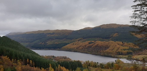
Photos of Perth and Kinross Region Mountain Bike
Videos of Perth and Kinross Region Mountain Bike
trail: Home Time
0:06 |
39 |
Mar 10, 2024
trail: Ben Chonzie Path
0:48 |
20 |
Jun 8, 2023
trail: Loamilicious
0:17 |
159 |
Dec 26, 2021
trail: Ballo Fast n Furious
2:51 |
459 |
Aug 9, 2020
trail: Rake & Ruin
7:57 |
189 |
Aug 14, 2019
trail: Rake & Ruin
6:26 |
88 |
Aug 14, 2019
trail: Electric Beaver
0:05 |
923 |
Jul 6, 2019
trail: Rake & Ruin
4:52 |
449 |
Feb 16, 2019
Current Trail Warnings
| status | trail | date | condition | user | info |
|---|---|---|---|---|---|
| Red DH, Part 2 Crieff Hydro Trails | Jun 6, 2026 @ 10:18am (Europe/London) Jun 6, 2026 | Wet | khs1 | Wildly overgrown. Bridges covered in moss... | |
| Ballo Walkers Path To Summit Ballo Wood | May 28, 2026 @ 12:05pm (Europe/London) May 28, 2026 | Unknown | Qbxne2 | Blocked and overgrown | |
| Cairn Free Strathtay & Grandtully Wood | May 26, 2026 @ 3:03pm (Europe/London) May 26, 2026 | Ideal | stuckbutton GMBC | Tree down across the trail, fairly... |
Recent Trail Reports
National Scenic Trails & Official Routes
-
Rob Roy Way
- Mountain Bike
- E-Bike
- Hike
- Trail Running
Activity Feed
| username | action | type | title | date |
|---|---|---|---|---|
| jo-nicholson | ridden | route | activity #97203256 | Jun 17, 2026 @ 12:32pm 12 hours |
| cook973 | add | report | activity #97176719 | Jun 17, 2026 @ 5:44am 19 hours |
| UnkleCornelius | wishlist | trail | activity #97063019 and 4 more | Jun 15, 2026 @ 1:37pm 2 days |
| UnkleCornelius | wishlist | trail | activity #97063002 | Jun 15, 2026 @ 1:36pm 2 days |
| UnkleCornelius | wishlist | trail | activity #97062928 and 8 more | Jun 15, 2026 @ 1:34pm 2 days |
Recent Comments
| username | type | title | comment | date |
|---|---|---|---|---|
| trail | ruts mut | Jun 5, 2026 @ 3:49pm Jun 5, 2026 | ||
| trail | Not worth the effort Walkers path | May 21, 2026 @ 7:04am May 21, 2026 | ||
| trail | Does not exist anymore by the looks of things | May 21, 2026 @ 7:01am May 21, 2026 | ||
| report | Forestry land and Scotland went in at the... | May 17, 2026 @ 11:50am May 17, 2026 | ||
| trail | Nice for an XC spin over the moor but it is... | May 6, 2026 @ 9:02am May 6, 2026 |
Local Badges
-

The 1hr Hally Sesh21 awarded -

Completionist0 awarded -
Completionist0 awarded -
Completionist0 awarded -
Completionist1 awarded -
Completionist9 awarded
Bike & Skill Parks
| name | type | city | rating |
|---|---|---|---|
| Pump & Skills Track | skill park | Crieff |
Activity Type Stats
| activitytype | trails | distance | descent | descent distance | total vertical | rating | global rank | state rank | photos | reports | routes | ridelogs |
|---|---|---|---|---|---|---|---|---|---|---|---|---|
| Mountain Bike | 872 | 566 miles | 120,879 ft | 264 miles | 3,392 ft | 810 | 6,102 | 34 | 59,526 | |||
| E-Bike | 782 | 474 miles | 96,759 ft | 215 miles | 3,392 ft | 20 | 5,523 | 12 | 10,908 | |||
| Gravel Bike | 1 | 70 | 3 | 187 | ||||||||
| Adaptive Bike | 1 | 1 | 1 | |||||||||
| Winter Fat Bike | 1 | 6 | 2 | 2 | ||||||||
| Horse | 101 | 88 miles | 9,806 ft | 36 miles | 1,378 ft | 726 | 2 | |||||
| Hike | 623 | 501 miles | 74,514 ft | 207 miles | 3,392 ft | 13 | 4,963 | 5 | 4,123 | |||
| Trail Running | 622 | 498 miles | 72,746 ft | 205 miles | 3,392 ft | 4,963 | 5 | 2,663 |
Frequently Asked Questions About Perth and Kinross Region
▼
What are the best places to ride in Perth and Kinross Region?
Perth and Kinross Region has 26 areas to explore for mountain biking. The top rated areas are:
▼
What are the highest rated mountain biking trails in Perth and Kinross Region?
The highest rated mountain biking trails in Perth and Kinross Region are:
- Riviera (4.6/5)
- Jalfrezi (4.5/5)
- Cookie Monster (4.5/5)
- Rake & Ruin (4.5/5)
- The Blue Route (4.5/5)
▼
What is the best time of the year to ride in Perth and Kinross Region?
Based on ride log data, the most popular months to ride in Perth and Kinross Region are:
- July (239 activities)
- June (201 activities)
- May (194 activities)
▼
What is the longest trail in Perth and Kinross Region?
The longest trail in Perth and Kinross Region is Beinn a Ghlo Loop Trail at 25.4 miles. View all trails sorted by distance.
Activities
Trails
- Hard trails in Perth and Kinross Region
- Easy trails in Perth and Kinross Region
- Favorite trails in Perth and Kinross Region
- Most ridden trails in Perth and Kinross Region
- Singletrack in Perth and Kinross Region
- Viewpoint trails in Perth and Kinross Region
- Trails with technical features in Perth and Kinross Region
- Race routes in Perth and Kinross Region
Points of Interest
- By 20twenty-p
 TVTA & contributors
 - Admins: UKTP, 20twenty-p, DMBinS, FLS, TTA
- #6240 - 26,646 views
- perth and kinross region activity log | embed map of Perth and Kinross Region mountain bike trails | perth and kinross region mountain biking points of interest polygons
Downloading of trail gps tracks in kml & gpx formats is enabled for Perth and Kinross Region.
You must login to download files.