close
-
Layers w
- Weather Layers
- Pro
- Pro
- Pro
- Pro
- Pro
- Pro
- More Layers
- Pro
- Pro
- Pro
- Pro
-
Upgrade to

3D
Trail Conditions
- Unknown
- Snow Groomed
- Snow Packed
- Snow Covered
- Snow Cover Partial
- Freeze/thaw Cycle
- Icy
- Prevalent Mud
- Wet
- Variable
- Ideal
- Dry
- Very Dry
Trail Flow (Ridden Direction)
Trailforks scans users ridelogs to determine the most popular direction each trail is ridden. A good flowing trail network will have most trails flowing in a single direction according to their intension.
The colour categories are based on what percentage of riders are riding a trail in its intended direction.
The colour categories are based on what percentage of riders are riding a trail in its intended direction.
- > 96%
- > 90%
- > 80%
- > 70%
- > 50%
- < 50%
- bi-directional trail
- no data
Trail Last Ridden
Trailforks scans ridelogs to determine the last time a trail was ridden.
- < 2 days
- < 1 week
- < 2 weeks
- < 1 month
- < 6 months
- > 6 months
Trail Ridden Direction
The intended direction a trail should be ridden.
- Downhill Only
- Downhill Primary
- Both Directions
- Uphill Primary
- Uphill Only
- One Direction
Contribute Details
Colors indicate trail is missing specified detail.
- Description
- Photos
- Description & Photos
- Videos
Trail Popularity ?
Trailforks scans ridelogs to determine which trails are ridden the most in the last 9 months.
Trails are compared with nearby trails in the same city region with a possible 25 colour shades.
Think of this as a heatmap, more rides = more kinetic energy = warmer colors.
- most popular
- popular
- less popular
- not popular
ATV/ORV/OHV Filter
Max Vehicle Width
inches
US Cell Coverage
Legend

Radar Time
Activity Recordings
Trailforks uses anonymized public activity data.
?
Activity Recordings
Trailforks uses anonymized public activity data.
?
Personal Heatmap
▶
Activity Types
all
/
none
▶
Options
2
Date range
month
–
Winter Trails
Warning
A routing network for winter maps does not exist. Selecting trails using the winter trails layer has been disabled.
Missing Trails
Most Popular
Least Popular
Trails are colored based on popularity. The more popular a trail is, the more red. Less popular trails trend towards green.
Jump Magnitude Heatmap
Heatmap of where riders jump on trails. Zoom in to see individual jumps, click circles to view jump details.
BC Backroad Status
![map legend]()
Service Road Atlas is a free to use, community-driven service for viewing and creating reports on the numerous back-country service roads around B.C. and Alberta.

Slope Aspect
Direction the slope faces
Trails Deemphasized
Trails are shown in grey.
Only show trails with no bike usage.
Suggested Layers
Based on selected activity type
Save the current map location and zoom level as your default home location whenever this page is loaded.
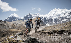
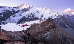
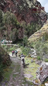
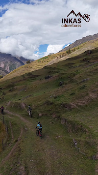
SavePeru is an amazing country that is getting very popular every year due to the type of trails. It is a country with a rich history and culture plus an amazing landscape that can be considered among the best spots on earth for mountain biking. There are 3 regions clearly marked: Coast, Andes and Jungle. In the 3 regions there are amazing ancient trails that have been made centuries ago
source: Inkas Adventures
Region Details
- 4
- 1
- 7
- 45
- 49
- 8
Stats
- Avg Trail Rating
- Trails (view details)
- 117
- Trails Mountain Bike
- 119
- Trails E-Bike
- 25
- Trails Horse
- 3
- Trails Hike
- 242
- Trails Trail Running
- 241
- Trails Dirtbike/Moto
- 2
- Trails Snowshoe
- 102
- Trails Downhill Ski
- 2
- Trails Backcountry Ski
- 2
- Trails Nordic Ski
- 2
- Total Distance
- 485 miles
- Total Descent
- 284,662 ft
- Total Vertical
- 16,027 ft
- Highest Trailhead
- 16,061 ft
- Reports
- 81
- Photos
- 1,185
- Ridden Counter
- 3,714
Articles

Race Report: DHI American Continental rd 2 Cusco - Peru
May 1, 2026 from pinkbike.com
Gonzalo Gajdosech defends his title in Cusco as the only rider to break 3:00, while Junior phenom Augusto Wening secures a World Cup Golden Ticket.
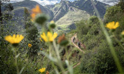
Photo & Video Story: More Than Dirt – Empowering Communities Through Trails in Peru
May 14, 2025 from pinkbike.com
A new grassroots project is using mountain biking not just to shred lines, but to build community, preserve culture, and create lasting change.
Video: Kurt Sorge, Geoff Gulevich, & Wolfgang Eysholdt on Unridden Terrain in 'Peru: How High'
Jun 16, 2023 from pinkbike.com
Their objective was to ride the highest elevation unridden terrain in the Peruvian Andes.
These Are the Bucket-List Hikes We're Dreaming About in 2022
Jan 18, 2022 from backpacker.com
Start planning a far-flung adventure with these 10 classic and soon-to-be-classic hikes.
Popular Trail Networks
view all areas »Sub Regions
- Canta (7)
- Cuzco Region (39)
- Sacred Valley (1)
- Abancay (1)
- Cusco (36)
- Sacred Valley (1)
- Department of Arequipa (8)
- Lima (0)
- Cajamarca (2)
- Huaraz (1)
- Lima (21)
- Ollantaytambo (4)
- Puerto Inca (0)
- Trujillo (20)
Popular Peru Mountain Biking Trails
• ★ 4.7 • 9 miles • 393 ft • 142 •
Lares Pass: Best trail I was able to ride during my time in Urubamba. You have 5000 feet of descent, starting at 14 600 feet on the Abra Lares and ending in Calca at 9600 feet. It starts with a high mountain feel: short grasses and a...
• 100 ★ 4.3 • 3 miles • 90 ft • 127 •
This is a classic downhill ride around Cusco where locals riders have built some jumps and nice stunts. The start is at the Ccorao Pass (on the way to Pisac) and goes through the small village of and ends down Cusco near the new mall....
• 100 ★ 5.0 • 1 mile • 550 ft • 90 •
Subida a las antenas del Morro Solar por las zetas
• 80 ★ 5.0 • 4 miles • 158 ft • 88 •
Starts in the Alpine and has a great view of Cusco city gets in to rocky sections. A lot of ichu (altitude grass).
• 100 ★ 4.5 • 2 miles • 52 ft • 83 •
This is a cool and short trail above Cusco that starts near the Inca site of Puca Pucara. It follows ancient paths down to the city of Cusco. The last part of this ride is through the stairs in the upper part of the city of Cusco.
• 95 ★ 5.0 • 2 miles • 441 ft • 50 •
Closest ride to Lima city. Sandy Morro Solar has a great view of Lima bay area.
• 85 ★ 4.0 • 1 mile • 0 ft • 46 •
Popular green difficulty singletrack. This mountain bike primary trail can be used downhill primary and has a moderate overall physical rating with a 0 ft green climb. On average it takes 8 minutes to complete this trail.
• 95 ★ 0.0 • 5,198 ft • 30 ft • 44 •
you´ll see local riders every sunday, be carefully with blind jumps
Peru Mountain Bike Routes
★ 5.0 • 32 miles • 402 ft • 0 •
You start at 3400m and finish at the ocean. This may be the biggest decent of any trail in the world....
14 miles • 2,242 ft • 1 •
This is a good nice ride through Pachacamac. You will pass through a small church, inca ruins, climb the...
6 miles • 1,782 ft • 2 • Loop •
Subida y bajada directa a la icónica baja DH del Prado
21 miles • 665 ft • 0 •
This is an easy ride that everybody can do it. There are no technical skills needed to make this ride. You...
4 miles • 18 ft • 0 • Shuttled •
Rough DH trail. Very complete. Has rock gardens, switchbacks, narrow sections and goes down fast. Clay...
10 miles • 1,278 ft • 0 • Shuttled •
16 kms of an old inca trail that suits for a techincal dh ride. Lots of rocks and ladders. Do the Langa...
Photos of Peru Mountain Bike
Videos of Peru Mountain Bike

trail: santisimo dh 2024
8:02 |
14 |
Apr 12, 2026
trail: Lares Pass
0:34 |
15 |
Jul 8, 2025
trail: Lares Pass
0:34 |
7 |
Jun 24, 2025
trail: santisimo dh 2024
0:27 |
46 |
Jan 28, 2025

trail: Jergón Trail
2:06 |
16 |
Jan 30, 2024
trail: Chirimoyo 1
4:04 |
34 |
Feb 11, 2023

trail: Yuncaypata
3:24 |
89 |
Jul 18, 2021
trail: Mollebaya DH
0:09 |
189 |
Aug 21, 2020
Recent Comments
| username | type | title | comment | date |
|---|---|---|---|---|
| trail | Brilliant trail. We started at the top,... | Nov 28, 2025 @ 3:45am Nov 28, 2025 | ||
| trail | Super diverse trail. Challenging steps at the... | Nov 28, 2025 @ 2:39am Nov 28, 2025 | ||
| trail | Fun descent (a bit like a Ledgeview style... | May 22, 2024 @ 9:15pm May 22, 2024 | ||
| trail | Awesome views & fun! Lots of grass &... | May 22, 2024 @ 9:14pm May 22, 2024 | ||
| trail | Quick & sweet descent into Cusco. (A... | May 22, 2024 @ 9:10pm May 22, 2024 |
Bike & Skill Parks
| name | type | city | rating |
|---|---|---|---|
| Pro Ramps Peru | skill park | Trujillo |
Upcoming Local Events
Activity Type Stats
| activitytype | trails | distance | descent | descent distance | total vertical | rating | global rank | state rank | photos | reports | routes | ridelogs |
|---|---|---|---|---|---|---|---|---|---|---|---|---|
| Mountain Bike | 118 | 461 miles | 269,852 ft | 340 miles | 16,027 ft | #59 | 1,185 | 81 | 17 | 34,811 | ||
| E-Bike | 25 | 91 miles | 48,747 ft | 62 miles | 14,626 ft | #68 | 74 | 1 | 3,332 | |||
| Horse | 3 | #78 | 28 | 1 | ||||||||
| Hike | 185 | 461 miles | 274,403 ft | 334 miles | 16,027 ft | #43 | 80 | 3 | 5,705 | |||
| Trail Running | 241 | 460 miles | 273,238 ft | 334 miles | 16,027 ft | #48 | 80 | 1 | 128 | |||
| Dirtbike/Moto | 2 | #75 | 28 | 3 | ||||||||
| Snowshoe | 102 | #44 | ||||||||||
| Downhill Ski | 2 | #44 | 10 | |||||||||
| Backcountry Ski | 2 | #46 | 5 | |||||||||
| Nordic Ski | 2 | #44 | 1 |
Activities
Trails
Points of Interest
- Quartelhuain Camping
- Soraypampa Camping
- Cacanapunta Viewpoint
- [cave] Cave Entrance Other
- Camping Aguas Ternales Viconga
- Patsa Wayi Lodge
- Alojamento Santa Rosa Lodge
- Huayllapa Camping
- Hospedaje Sol de Yerupaja Lodge
- Windcamping Spot
- Huascarán Sur (6,606 m)
- Coropuna Oeste (6,404 m)
- Nevado Coropuna (6,394 m)
- By canadaka
 Trailforks & contributors
 - Admins: HolyTrailsMTB
- #3253 - 17,851 views
- peru activity log | embed map of Peru mountain bike trails | peru mountain biking points of interest
Downloading of trail gps tracks in kml & gpx formats is enabled for Peru.
You must login to download files.