close
-
Layers w
- Weather Layers
- Pro
- Pro
- Pro
- Pro
- Pro
- Pro
- More Layers
- Pro
- Pro
- Pro
- Pro
-
Upgrade to

3D
Trail Conditions
- Unknown
- Snow Groomed
- Snow Packed
- Snow Covered
- Snow Cover Partial
- Freeze/thaw Cycle
- Icy
- Prevalent Mud
- Wet
- Variable
- Ideal
- Dry
- Very Dry
Trail Flow (Ridden Direction)
Trailforks scans users ridelogs to determine the most popular direction each trail is ridden. A good flowing trail network will have most trails flowing in a single direction according to their intension.
The colour categories are based on what percentage of riders are riding a trail in its intended direction.
The colour categories are based on what percentage of riders are riding a trail in its intended direction.
- > 96%
- > 90%
- > 80%
- > 70%
- > 50%
- < 50%
- bi-directional trail
- no data
Trail Last Ridden
Trailforks scans ridelogs to determine the last time a trail was ridden.
- < 2 days
- < 1 week
- < 2 weeks
- < 1 month
- < 6 months
- > 6 months
Trail Ridden Direction
The intended direction a trail should be ridden.
- Downhill Only
- Downhill Primary
- Both Directions
- Uphill Primary
- Uphill Only
- One Direction
Contribute Details
Colors indicate trail is missing specified detail.
- Description
- Photos
- Description & Photos
- Videos
Trail Popularity ?
Trailforks scans ridelogs to determine which trails are ridden the most in the last 9 months.
Trails are compared with nearby trails in the same city region with a possible 25 colour shades.
Think of this as a heatmap, more rides = more kinetic energy = warmer colors.
- most popular
- popular
- less popular
- not popular
ATV/ORV/OHV Filter
Max Vehicle Width
inches
US Cell Coverage
Legend

Radar Time
Activity Recordings
Trailforks uses anonymized public activity data.
?
Activity Recordings
Trailforks uses anonymized public activity data.
?
Personal Heatmap
▶
Activity Types
all
/
none
▶
Options
2
Date range
month
–
Winter Trails
Warning
A routing network for winter maps does not exist. Selecting trails using the winter trails layer has been disabled.
Missing Trails
Most Popular
Least Popular
Trails are colored based on popularity. The more popular a trail is, the more red. Less popular trails trend towards green.
Jump Magnitude Heatmap
Heatmap of where riders jump on trails. Zoom in to see individual jumps, click circles to view jump details.
BC Backroad Status
![map legend]()
Service Road Atlas is a free to use, community-driven service for viewing and creating reports on the numerous back-country service roads around B.C. and Alberta.

Slope Aspect
Direction the slope faces
Trails Deemphasized
Trails are shown in grey.
Only show trails with no bike usage.
Suggested Layers
Based on selected activity type
Save the current map location and zoom level as your default home location whenever this page is loaded.
SavePeshkopi is a town in Dibër County, northeastern Albania. At the 2015 local government reform it became a subdivision of the municipality Dibër. The population at the 2011 census was 13,251.
The town is located 187 kilometres (116 mi) away from Tirana, the capital of Albania, and 20 kilometres (12 mi) from Macedonian border, and it sits 651 metres (2,136 ft) above sea level. It is the capital of both the county (Albanian: qark) and district (Albanian: rreth) of Dibër. It is the only county capital in Albania that does not share its name with its county.
Peshkopi lies east of the Black Drin river. The Drin valley is the lowest part of the district. Mineral ores such as chromium, sulphur, and marble have been discovered in the district. It is also an important industrial center in Albania, particularly in relation to the food industry.
The predominant form of tourism in the region is mountain tourism, due to the hilly terrain and large amount of forest. In the district of Dibra lie two of the thirteen national parks in Albania, Lurë National Park, and Korab-Koritnik Nature Park which offer mountain tourism in the winter and summer, including climbing, walking, skiing, trekking, picnics, hunting, kayaking, etc.
The museum, located beside the general secondary school, houses a collection of local costumes, carpets, kitchen equipment and filigree jewelry, as well as a number of models of local architecture.
Thermal mineral water springs and sulphur baths (Albanian: llixha) in the vicinity of Peshkopi are a draw for seasonal tourism, primarily from within Albania, but also to a lesser extent from neighboring countries. They are reputed to alleviate some health issues.The baths are located a short distance east of the city, upstream along the creek which runs through the middle of Peshkopi.
Activities Click to view
- Mountain Bike
63 trails
- E-Bike
63 trails
- Adaptive Bike
0 trails
- Horse
25 trails
- Hike
68 trails
- Trail Running
66 trails
- Dirtbike/Moto
11 trails
- Observed Trials
10 trails
- ATV/ORV/OHV
13 trails
- Snowmobile
3 trails
- Snowshoe
2 trails
Region Details
- 15
- 7
- 32
- 8
Region Status
Caution as of May 25, 2026Stats
- Avg Trail Rating
- Trails (view details)
- 64
- Trails Mountain Bike
- 63
- Trails E-Bike
- 63
- Trails Horse
- 25
- Trails Hike
- 68
- Trails Trail Running
- 66
- Trails Dirtbike/Moto
- 11
- Trails Observed Trials
- 10
- Trails ATV/ORV/OHV
- 13
- Trails Snowmobile
- 3
- Trails Snowshoe
- 2
- Trails Backcountry Ski
- 1
- Total Distance
- 146 miles
- Total Descent
- 69,274 ft
- Total Vertical
- 6,538 ft
- Highest Trailhead
- 7,743 ft
- Reports
- 24
- Photos
- 62
- Ridden Counter
- 119
Sub Regions
-
Dibër
- 5
- 2
-
Korab-Koritnik Nature Park
- 2
- 18
- 4
-
Lurë National Park
- 2
-
Luzni-Bulaç natural park
- 1
Popular Peshkopi Mountain Biking Trails
• 5 ★ 4.8 • 2 miles • 19 ft • 8 •
Less popular blue difficulty alpine singletrack. This mountain bike primary trail and has a moderate overall physical rating. It features berm, drop, rock face and rock garden. Trail visibility is always easy to follow. On average it takes 25 minutes to complete this trail.
• 5 ★ 3.0 • 1 mile • 34 ft • 7 •
Less popular blue difficulty alpine singletrack. This mountain bike primary trail can be used downhill only and has a hard overall physical rating. It features berm and rock garden. Trail visibility is always easy to follow. On average it takes 17 minutes to complete this trail.
• 5 ★ 3.4 • 4 miles • 51 ft • 5 •
This trail has been reconstructed as part of a cross-border project between Albania and North Macedonia. It has been cured to the details, so watch out for the many hidden features to get the most fun out of it.
• 5 ★ 0.0 • 3 miles • 239 ft • 2 •
Less popular blue difficulty mixed. This mountain bike primary trail can be used both directions and has a hard overall physical rating with a 239 ft blue climb. Trail visibility is always easy to follow. On average it takes 36 minutes to complete this trail.
• 5 ★ 0.0 • 3 miles • 31 ft • 2 •
Less popular blue difficulty alpine singletrack. This mountain bike primary trail can be used downhill only and has a moderate overall physical rating. It features berm. Trail visibility is always easy to follow.
• 5 ★ 0.0 • 1 mile • 0 ft • 2 •
Less popular blue difficulty mixed. This mountain bike primary trail can be used downhill primary and has a moderate overall physical rating with a 0 ft black diamond climb. Trail visibility is sometimes hard to follow. On average it takes 16 minutes to complete this trail.
• 5 ★ 0.0 • 4,833 ft • 43 ft • 1 •
Less popular blue difficulty singletrack. This mountain bike primary trail can be used both directions with a 43 ft black diamond climb. Trail visibility is always easy to follow.
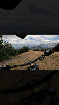
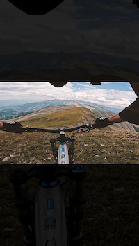
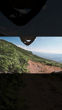
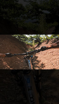
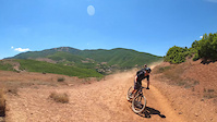
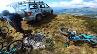
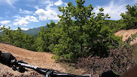
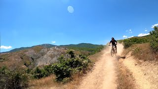
Photos of Peshkopi Mountain Bike
Videos of Peshkopi Mountain Bike
0:18 |
19 |
Aug 17, 2023
trail: Hinoskë - Maja e Velivarit
0:15 |
31 |
Aug 17, 2023
0:09 |
14 |
Aug 17, 2023
0:18 |
20 |
Aug 17, 2023
trail: Moab of Albania
0:36 |
|
Mar 7, 2023
trail: Hinoske - Ilnice Trail
0:48 |
|
Nov 23, 2021
trail: Mazhica tunnel
0:46 |
12 |
Jul 27, 2021
trail: Moab of Albania
6:56 |
176 |
Mar 7, 2023 , Peshkopi
Recent Trail Reports
| status | trail | date | condition | info | user |
|---|---|---|---|---|---|
| Moab of Albania | Aug 20, 2024 @ 12:56pm Aug 20, 2024 | Ideal | eli_webi | ||
| Hinoske - Ilnice Trail | Oct 6, 2023 @ 6:32am Oct 6, 2023 | Dry | Benediktujrc4 | ||
| Pejke - Hotesh Trail | Aug 13, 2023 @ 8:50am Aug 13, 2023 | Dry | outfaced KrivaSpitsa |
Activity Feed
| username | action | type | title | date |
|---|---|---|---|---|
| Bikios | wishlist | trail | activity #96592082 | Jun 9, 2026 @ 2:16am Jun 9, 2026 |
| lane6riders | wishlist | trail | activity #86789061 and 2 more | Jan 7, 2026 @ 3:44am Jan 7, 2026 |
| andiqyqja | add | photo | activity #79552290 and 5 more | Sep 3, 2025 @ 7:25am Sep 3, 2025 |
| andiqyqja | add | trail | activity #79549786 and 1 more | Sep 3, 2025 @ 6:38am Sep 3, 2025 |
| andiqyqja | add | photo | activity #78926147 and 12 more | Aug 25, 2025 @ 11:02am Aug 25, 2025 |
Recent Comments
| username | type | title | comment | date |
|---|---|---|---|---|
| trail | Quite flowy. It kinda feels like freeriding,... | Aug 20, 2024 @ 12:59pm Aug 20, 2024 | ||
| trail | Flowtrail, beautiful, scenic! | Jun 27, 2024 @ 9:33am Jun 27, 2024 | ||
| trail | Amazing nature, wild and originally. | Oct 5, 2023 @ 6:51am Oct 5, 2023 | ||
| trail | Super scenic and flowy upper part on the edge... | Oct 5, 2023 @ 6:49am Oct 5, 2023 |
Local Badges
-

Completionist0 awarded -

10 Blue Trails0 awarded -

Epic Mountain Bike Climb 2k9 awarded -

Climbing 10k Badge0 awarded -

Mountain Biking 100k Badge0 awarded -

Epic Ride Descent 2k9 awarded
Activity Type Stats
| activitytype | trails | distance | descent | descent distance | total vertical | rating | global rank | state rank | photos | reports | routes | ridelogs |
|---|---|---|---|---|---|---|---|---|---|---|---|---|
| Mountain Bike | 63 | 140 miles | 64,892 ft | 93 miles | 6,365 ft | #1,105 | #2 | 65 | 24 | 85 | ||
| E-Bike | 63 | 140 miles | 64,892 ft | 93 miles | 6,365 ft | #500 | #2 | 23 | 6 | |||
| Horse | 25 | 52 miles | 13,281 ft | 22 miles | 5,138 ft | #224 | #7 | 1 | ||||
| Hike | 68 | 146 miles | 69,275 ft | 97 miles | 6,539 ft | #380 | #3 | 23 | 55 | |||
| Trail Running | 66 | 146 miles | 69,275 ft | 97 miles | 6,539 ft | #567 | #2 | 23 | ||||
| Dirtbike/Moto | 11 | 34 miles | 3,428 ft | 10 miles | 5,138 ft | #218 | #6 | |||||
| Observed Trials | 10 | 31 miles | 3,615 ft | 10 miles | 5,138 ft | #44 | #3 | |||||
| ATV/ORV/OHV | 13 | 35 miles | 3,684 ft | 11 miles | 5,138 ft | #128 | #7 | |||||
| Snowmobile | 3 | 12 miles | 1,650 ft | 3 miles | 2,966 ft | #95 | #1 | |||||
| Snowshoe | 2 | 5 miles | 2,595 ft | 4 miles | 2,470 ft | #255 | #5 | |||||
| Backcountry Ski | 1 | 2 |
Frequently Asked Questions About Peshkopi
▼
What are the best places to ride in Peshkopi?
Peshkopi has 4 areas to explore for mountain biking. The top rated areas are:
▼
What are the highest rated mountain biking trails in Peshkopi?
The highest rated mountain biking trails in Peshkopi are:
- Hinoske - Ilnice Trail (4.3/5)
- Moab of Albania (4.1/5)
- Fush-Karrabac Trail (4/5)
- 3X border corner (4/5)
- Pejke - Hotesh Trail (3.8/5)
▼
Where can I park to ride in Peshkopi?
Check the Peshkopi trail map for trailhead and parking information. Community members regularly update access and parking details for trails in the area.
▼
What is the longest trail in Peshkopi?
The longest trail in Peshkopi is 3X border corner at 7.3 miles. View all trails sorted by distance.
Activities
Trails
Points of Interest
- By BikeClubTirana BCT & contributors
- Admins: andiqyqja
- #21553 - 3,376 views
- peshkopi activity log | embed map of Peshkopi mountain bike trails |
Downloading of trail gps tracks in kml & gpx formats is enabled for Peshkopi.
You must login to download files.