close
-
Layers w
- Weather Layers
- Pro
- Pro
- Pro
- Pro
- Pro
- Pro
- More Layers
- Pro
- Pro
- Pro
- Pro
-
Upgrade to

3D
Trail Conditions
- Unknown
- Snow Groomed
- Snow Packed
- Snow Covered
- Snow Cover Partial
- Freeze/thaw Cycle
- Icy
- Prevalent Mud
- Wet
- Variable
- Ideal
- Dry
- Very Dry
Trail Flow (Ridden Direction)
Trailforks scans users ridelogs to determine the most popular direction each trail is ridden. A good flowing trail network will have most trails flowing in a single direction according to their intension.
The colour categories are based on what percentage of riders are riding a trail in its intended direction.
The colour categories are based on what percentage of riders are riding a trail in its intended direction.
- > 96%
- > 90%
- > 80%
- > 70%
- > 50%
- < 50%
- bi-directional trail
- no data
Trail Last Ridden
Trailforks scans ridelogs to determine the last time a trail was ridden.
- < 2 days
- < 1 week
- < 2 weeks
- < 1 month
- < 6 months
- > 6 months
Trail Ridden Direction
The intended direction a trail should be ridden.
- Downhill Only
- Downhill Primary
- Both Directions
- Uphill Primary
- Uphill Only
- One Direction
Contribute Details
Colors indicate trail is missing specified detail.
- Description
- Photos
- Description & Photos
- Videos
Trail Popularity ?
Trailforks scans ridelogs to determine which trails are ridden the most in the last 9 months.
Trails are compared with nearby trails in the same city region with a possible 25 colour shades.
Think of this as a heatmap, more rides = more kinetic energy = warmer colors.
- most popular
- popular
- less popular
- not popular
ATV/ORV/OHV Filter
Max Vehicle Width
inches
US Cell Coverage
Legend

Radar Time
Activity Recordings
Trailforks uses anonymized public activity data.
?
Activity Recordings
Trailforks uses anonymized public activity data.
?
Personal Heatmap
▶
Activity Types
all
/
none
▶
Options
2
Date range
month
–
Winter Trails
Warning
A routing network for winter maps does not exist. Selecting trails using the winter trails layer has been disabled.
Missing Trails
Most Popular
Least Popular
Trails are colored based on popularity. The more popular a trail is, the more red. Less popular trails trend towards green.
Jump Magnitude Heatmap
Heatmap of where riders jump on trails. Zoom in to see individual jumps, click circles to view jump details.
BC Backroad Status
![map legend]()
Service Road Atlas is a free to use, community-driven service for viewing and creating reports on the numerous back-country service roads around B.C. and Alberta.

Slope Aspect
Direction the slope faces
Trails Deemphasized
Trails are shown in grey.
Only show trails with no bike usage.
Suggested Layers
Based on selected activity type
Save the current map location and zoom level as your default home location whenever this page is loaded.
Save
No description for Petoskey has been added yet!
Login or register to submit one.
Activities Click to view
- Mountain Bike
51 trails
- E-Bike
6 trails
- Gravel Bike
0 trails
- Adaptive Bike
0 trails
- Winter Fat Bike
0 trails
- Hike
94 trails
- Trail Running
94 trails
- Snowshoe
63 trails
Region Details
- 8
- 39
- 2
- 2
Region Status
Open as of Jun 15, 2026Stats
- Avg Trail Rating
- Trails (view details)
- 94
- Trails Mountain Bike
- 51
- Trails E-Bike
- 6
- Trails Hike
- 94
- Trails Trail Running
- 94
- Trails Snowshoe
- 63
- Total Distance
- 56 miles
- Total Descent Distance
- 21 miles
- Total Descent
- 3,899 ft
- Total Vertical
- 701 ft
- Highest Trailhead
- 1,283 ft
- Reports
- 142
- Photos
- 18
- Ridden Counter
- 2,922
Sub Regions
-
Cherry Lane Nature Area
- 4
-
McCune Preserve
- 25
-
Petosky State Park
- 3
-
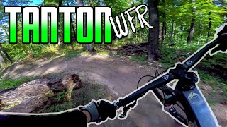
Tanton WFR
- 3
- 1
- 1
Popular Petoskey Mountain Biking Trails
• 95 ★ 4.5 • 2 miles • 328 ft • 265 •
This trail pushes continues to push the grade to reach the summit. Narrow and fast with some creative use of the topography to incorporate berms or banked turns into the tread. A modest native rock feature marks the summit and a...
• 100 ★ 4.4 • 2 miles • 282 ft • 226 •
Highly rated popular green difficulty singletrack. This mountain bike primary trail can be used both directions. On average it takes 11 minutes to complete this trail.
• 90 ★ 5.0 • 2 miles • 298 ft • 196 •
Highly rated popular blue difficulty singletrack. This mountain bike primary trail can be used both directions. Trail visibility is always easy to follow. On average it takes 16 minutes to complete this trail.
• 90 ★ 5.0 • 3 miles • 49 ft • 133 •
Popular green difficulty mixed. This multi-use trail can be used both directions and has a easy overall physical rating with a 49 ft green climb. Trail visibility is always easy to follow. On average it takes 17 minutes to complete this trail.
• 95 ★ 0.0 • 4,436 ft • 95 ft • 125 •
1st of 2 beginner level trail loops being added to the Tanton WFR trails.
• 100 ★ 0.0 • 3,133 ft • 17 ft • 88 •
2nd of 2 beginner level trail loops added to the Tanton WFR trails. Follow the daily directional convention of the trail system.
• 90 ★ 0.0 • 705 ft • 0 ft • 59 •
Popular green difficulty singletrack. This multi-use trail can be used both directions. On average it takes minutes to complete this trail.
• 80 ★ 0.0 • 4 miles • 387 ft • 51 •
Great section of the NCT that descends from Krause Rd. at a local high point populated with radio towers. Mostly singletrack with some double track connectors. This trail also has lots of variety, with some sand, some regular soil, and...
Petoskey Mountain Bike Routes
24 miles • 470 ft • 5 • Point to Point •
The “Bike Path”, as it is locally called, runs 26 miles from Charlevoix to Harbor Springs in...
Photos of Petoskey Mountain Bike
Videos of Petoskey Mountain Bike
8:48 |
608 |
Nov 10, 2020
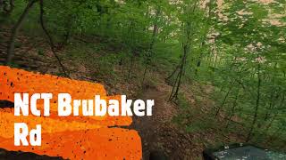
trail: NCT - Krause Rd to Taylor Rd
0:36 |
437 |
Sep 10, 2020 , Petoskey
Recent Trail Reports
| status | trail | date | condition | info | user |
|---|---|---|---|---|---|
| Cherry Lane Blue Trail | Jun 15, 2026 @ 8:45pm (America/Menominee) Jun 15, 2026 | Ideal | linden44 TOMMBA | ||
| Cherry Lane Red Loop | Jun 15, 2026 @ 8:45pm (America/Menominee) Jun 15, 2026 | Ideal | linden44 TOMMBA | ||
| Cherry Lane Blue Loop | Jun 15, 2026 @ 8:45pm (America/Menominee) Jun 15, 2026 | Ideal | linden44 TOMMBA | ||
| Cherry Lane Red Trail | Jun 15, 2026 @ 8:45pm (America/Menominee) Jun 15, 2026 | Ideal | linden44 TOMMBA | ||
| Green Trail | Jun 11, 2026 @ 6:56pm (America/Detroit) Jun 11, 2026 | Ideal | cowan8732 | ||
| Black Trail | Jun 11, 2026 @ 6:55pm (America/Detroit) Jun 11, 2026 | Ideal | cowan8732 | ||
| Blue Trail | May 14, 2026 @ 8:22pm (America/Detroit) May 14, 2026 | Ideal | cowan8732 | ||
| Beginner North Loop | May 14, 2026 @ 8:22pm (America/Detroit) May 14, 2026 | Variable | cowan8732 | ||
| Beginner South Loop | May 14, 2026 @ 8:21pm (America/Detroit) May 14, 2026 | Variable | cowan8732 | ||
| NCT - Krause Rd to Taylor Rd | Apr 26, 2026 @ 4:56pm (America/Detroit) Apr 26, 2026 | Ideal | cowan8732 |
Activity Feed
| username | action | type | title | date |
|---|---|---|---|---|
| linden44 | add | report | activity #97104509 and 3 more | Jun 16, 2026 @ 6:17am Jun 16, 2026 |
| cowan8732 | add | report | activity #96765964 and 1 more | Jun 11, 2026 @ 3:55pm Jun 11, 2026 |
| ChrystalnNteUc | wishlist | region | activity #95688643 | May 27, 2026 @ 11:28pm May 27, 2026 |
| ChrystalnNteUc | wishlist | region | activity #95574721 | May 26, 2026 @ 10:35am May 26, 2026 |
| cowan8732 | add | report | activity #94934965 | May 17, 2026 @ 1:19pm May 17, 2026 |
Recent Comments
| username | type | title | comment | date |
|---|---|---|---|---|
| report | @cowan8732 Thanks John. | Sep 25, 2025 @ 6:07pm Sep 25, 2025 | ||
| report | All clear now. | Sep 25, 2025 @ 3:23pm Sep 25, 2025 | ||
| report | Thanks guys! | Sep 24, 2025 @ 6:29pm Sep 24, 2025 | ||
| trail | No Bikes signs , October 2023 | Oct 4, 2023 @ 9:37am Oct 4, 2023 | ||
| trail | Fun trail, a lot of sand but that's hard to... | Sep 16, 2021 @ 2:32pm Sep 16, 2021 |
Local Badges
-

Epic Mountain Bike Climb 2k1 awarded -

Climbing 10k Badge15 awarded -

Mountain Biking 100k Badge2 awarded -

Epic Ride Descent 2k1 awarded -

Descent 10k Badge15 awarded -

Descent 100k Badge2 awarded
Activity Type Stats
| activitytype | trails | distance | descent | descent distance | total vertical | rating | global rank | state rank | photos | reports | routes | ridelogs |
|---|---|---|---|---|---|---|---|---|---|---|---|---|
| Mountain Bike | 51 | 36 miles | 2,963 ft | 15 miles | 702 ft | #3,516 | #1,201 | 16 | 141 | 2 | 5,158 | |
| E-Bike | 6 | 8 miles | 955 ft | 3 miles | 430 ft | #7,832 | #2,366 | 138 | 1 | 136 | ||
| Hike | 94 | 56 miles | 3,898 ft | 21 miles | 702 ft | #3,422 | #1,205 | 2 | 142 | 1 | 557 | |
| Trail Running | 94 | 56 miles | 3,898 ft | 21 miles | 702 ft | #3,582 | #1,070 | 142 | 1 | 457 | ||
| Snowshoe | 63 | 20 miles | 1,434 ft | 7 miles | 673 ft | #654 | #269 | 30 |
Frequently Asked Questions About Petoskey
▼
What are the best places to ride in Petoskey?
Petoskey has 8 areas to explore for mountain biking. The top rated areas are:
▼
What are the highest rated mountain biking trails in Petoskey?
The highest rated mountain biking trails in Petoskey are:
- Blue Trail (4.5/5)
- Black Trail (4.2/5)
- Green Trail (4.2/5)
- NCT - Little Traverse Wheelway (4.1/5)
- NCT - Krause Rd to Taylor Rd (0/5)
▼
What is the best time of the year to ride in Petoskey?
Based on ride log data, the most popular months to ride in Petoskey are:
- September (58 activities)
- August (41 activities)
- July (34 activities)
▼
Where can I park to ride in Petoskey?
There are 12 parking locations listed in Petoskey. The most popular parking spots are: View all parking and trailhead locations on the map to plan your visit.
Activities
Trails
Points of Interest
- By brenthillier
 NSMBA TRAILFORKS & contributors
 - Admins: TOMMBA
- #22100 - 5,796 views
- petoskey activity log | embed map of Petoskey mountain bike trails | petoskey mountain biking points of interest
Downloading of trail gps tracks in kml & gpx formats is enabled for Petoskey.
You must login to download files.