close
-
Layers w
- Weather Layers
- Pro
- Pro
- Pro
- Pro
- Pro
- Pro
- More Layers
- Pro
- Pro
- Pro
- Pro
-
Upgrade to

3D
Trail Conditions
- Unknown
- Snow Groomed
- Snow Packed
- Snow Covered
- Snow Cover Partial
- Freeze/thaw Cycle
- Icy
- Prevalent Mud
- Wet
- Variable
- Ideal
- Dry
- Very Dry
Trail Flow (Ridden Direction)
Trailforks scans users ridelogs to determine the most popular direction each trail is ridden. A good flowing trail network will have most trails flowing in a single direction according to their intension.
The colour categories are based on what percentage of riders are riding a trail in its intended direction.
The colour categories are based on what percentage of riders are riding a trail in its intended direction.
- > 96%
- > 90%
- > 80%
- > 70%
- > 50%
- < 50%
- bi-directional trail
- no data
Trail Last Ridden
Trailforks scans ridelogs to determine the last time a trail was ridden.
- < 2 days
- < 1 week
- < 2 weeks
- < 1 month
- < 6 months
- > 6 months
Trail Ridden Direction
The intended direction a trail should be ridden.
- Downhill Only
- Downhill Primary
- Both Directions
- Uphill Primary
- Uphill Only
- One Direction
Contribute Details
Colors indicate trail is missing specified detail.
- Description
- Photos
- Description & Photos
- Videos
Trail Popularity ?
Trailforks scans ridelogs to determine which trails are ridden the most in the last 9 months.
Trails are compared with nearby trails in the same city region with a possible 25 colour shades.
Think of this as a heatmap, more rides = more kinetic energy = warmer colors.
- most popular
- popular
- less popular
- not popular
ATV/ORV/OHV Filter
Max Vehicle Width
inches
US Cell Coverage
Legend

Radar Time
Activity Recordings
Trailforks uses anonymized public activity data.
?
Activity Recordings
Trailforks uses anonymized public activity data.
?
Personal Heatmap
▶
Activity Types
all
/
none
▶
Options
2
Date range
month
–
Winter Trails
Warning
A routing network for winter maps does not exist. Selecting trails using the winter trails layer has been disabled.
Missing Trails
Most Popular
Least Popular
Trails are colored based on popularity. The more popular a trail is, the more red. Less popular trails trend towards green.
Jump Magnitude Heatmap
Heatmap of where riders jump on trails. Zoom in to see individual jumps, click circles to view jump details.
BC Backroad Status
![map legend]()
Service Road Atlas is a free to use, community-driven service for viewing and creating reports on the numerous back-country service roads around B.C. and Alberta.

Slope Aspect
Direction the slope faces
Trails Deemphasized
Trails are shown in grey.
Only show trails with no bike usage.
Suggested Layers
Based on selected activity type
Save the current map location and zoom level as your default home location whenever this page is loaded.
Save
No description for Phoenix has been added yet!
Login or register to submit one.

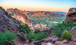
IMBA Ride Center
Valley of the Sun
Activities Click to view
- Mountain Bike
440 trails
- E-Bike
304 trails
- Gravel Bike
31 trails
- Adaptive Bike
36 trails
- Horse
112 trails
- Hike
453 trails
- Trail Running
453 trails
- Dirtbike/Moto
0 trails
- ATV/ORV/OHV
0 trails
Region Details
- 39
- 15
- 147
- 164
- 51
- 23
Region Status
Open as of 6 hoursLocal Trail Association
Stats
- Avg Trail Rating
- Trails (view details)
- 457
- Trails Mountain Bike
- 440
- Trails E-Bike
- 304
- Trails Gravel Bike
- 31
- Trails Adaptive Bike
- 36
- Trails Winter Fat Bike
- 5
- Trails Horse
- 112
- Trails Hike
- 453
- Trails Trail Running
- 453
- Total Distance
- 427 miles
- Total Descent
- 52,044 ft
- Total Vertical
- 1,623 ft
- Highest Trailhead
- 2,672 ft
- Reports
- 5,031
- Photos
- 1,336
- Ridden Counter
- 191,992
Articles
The Best Trails in Phoenix for All Types of Hikers
Mar 16, 2022 from backpacker.com
Dayhikes, backpacking, family-friendly trails–Phoenix has hiking for everybody, and it's some of the country's best.

Arizona's 5 Most Popular Trail Networks According to Trailforks Data
Oct 19, 2021 from pinkbike.com
The American Southwest is chock full of bucket list locales, and perhaps no single southwestern state is home to more of them than Arizona.
Sub Regions
-
Deem Hills
- 1
- 3
- 5
- 1
-
Echo Canyon Recreation Area
-
Lookout Mountain Preserve
- 32
- 3
- 1
-
Phoenix Mountain Preserve
- 1
- 32
- 43
- 20
- 6
-
Phoenix Mountain Preserve - North Mountain / Shaw Butte
- 1
- 7
- 7
- 2
-
Phoenix Sonoran Preserve
- 3
- 16
- 17
- 2
- 1
-
Pyramid Peak
- 8
- 39
- 1
-
Reach 11 Recreation Area
- 7
-
Rio Salado Habitat Restoration Area
-
South Mountain Preserve
- 5
- 38
- 54
- 25
- 16
Popular Phoenix Mountain Biking Trails
• 100 ★ 4.0 • 1 mile • 3 ft • 3,474 •
As of summer 2023, " Loop" is officially gone as a trail name. As per the South Mountain 2017 Trails Master Plan, has been extended west to incorporate the old Loop Trail. These changes will be reflected on updated trail maps and on...
• 100 ★ 3.9 • 2 miles • 38 ft • 2,905 •
Popular blue difficulty singletrack. This multi-use trail can be used both directions and has a moderate overall physical rating with a 38 ft blue climb. Trail visibility is always easy to follow. On average it takes 17 minutes to complete this trail.
• 100 ★ 4.0 • 1,165 ft • 17 ft • 2,573 •
Highly rated popular blue difficulty family friendly singletrack. This multi-use trail can be used both directions and has a moderate overall physical rating with a 17 ft blue climb. It features rock garden. Trail visibility is always easy to follow. On average it takes 1 minutes to complete this trail.
• 100 ★ 4.2 • 1 mile • 187 ft • 2,329 •
Alternate route to this section of . As of 2024, the old " " is being adopted into as its lower section. In future years, " " may be adopted into a greater " Loop Trail."
• 100 ★ 2.5 • 1,608 ft • 0 ft • 2,187 •
Alignment of the new trail per the South Mountain 2017 trails master plan.
• 100 ★ 2.8 • 3,455 ft • 0 ft • 2,129 •
Popular green difficulty singletrack. This multi-use trail can be used both directions and has a easy overall physical rating with a 0 ft green climb. On average it takes 6 minutes to complete this trail.
• 90 ★ 4.0 • 9 miles • 686 ft • 1,988 •
trail connects the east and west ends of the southwest quadrant of south mountain riding area. About 13 miles across the lower flats of the south west range it ascends from east to west and descends west to east. Canyon which is a large...
Phoenix Mountain Bike Routes
★ 4.0 • 10 miles • 1,446 ft • 34 • Out & Back •
Relatively short out-n-back with a central loop on the most popular section of the mountain. This route...
★ 2.0 • 6 miles • 179 ft • 2 • Loop •
Easy and flat loop. Good for beginners with the most difficult parts being several wash crossings and some...
★ 4.0 • 12 miles • 1,621 ft • 13 •
lot to out and back from Buena Vista with Javelina- loop
★ 4.0 • 11 miles • 734 ft • 2 • Loop •
Easy ride up looping through the top of , then back down .
★ 4.0 • 3 miles • 543 ft • 3 • Out & Back •
Nice ride on , then a hard grind up to and old helicopter pad for a nice view of Phoenix's East Valley.
Photos of Phoenix Mountain Bike
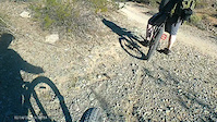
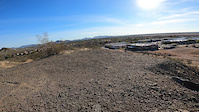
Videos of Phoenix Mountain Bike
trail: CMC 100 Connect
2:00 |
5 |
Feb 14, 2026

trail: Rocky Road Ridgeline
2:23 |
14 |
Jan 3, 2026
trail: National (Dirt Road)
0:18 |
|
Jan 20, 2025
trail: Zipline
2:03 |
42 |
Jan 18, 2024
trail: White Widow
0:21 |
37 |
Jan 17, 2024

trail: Lookout Mtn (308)
10:58 |
77 |
Nov 24, 2023
trail: Tondum Wihom (Lower)
0:21 |
|
Apr 13, 2023
trail: Javelina Canyon
6:14 |
238 |
Apr 11, 2022
Recent Trail Reports
| status | trail | date | condition | info | user |
|---|---|---|---|---|---|
| Guadalupe Perimeter Trail Acc | Jun 24, 2026 @ 4:48am (America/Phoenix) 6 hours | Dry | dlr1967 | ||
| Corona Conn | Jun 24, 2026 @ 4:48am (America/Phoenix) 6 hours | Dry | dlr1967 | ||
| Gila | Jun 22, 2026 @ 6:25pm (America/Phoenix) 2 days | Dry | azmtnrider | ||
| Connector | Jun 22, 2026 @ 6:25pm (America/Phoenix) 2 days | Dry | azmtnrider | ||
| Telegraph Pass | Jun 18, 2026 @ 6:38pm (America/Phoenix) Jun 18, 2026 | Dry | azmtnrider | ||
| Cliff Walk | Jun 4, 2026 @ 7:18am (America/Phoenix) Jun 4, 2026 | Ideal | jt3mtb | ||
| Esplanade | Jun 4, 2026 @ 7:18am (America/Phoenix) Jun 4, 2026 | Ideal | jt3mtb | ||
| Corona/DC Conn | Jun 3, 2026 @ 4:55am (America/Phoenix) Jun 3, 2026 | Dry | dlr1967 | ||
| Thash Kavid | Jun 3, 2026 @ 4:55am (America/Phoenix) Jun 3, 2026 | Dry | dlr1967 | ||
| Trail 101 | Jun 1, 2026 @ 6:17am (America/Phoenix) Jun 1, 2026 | Very Dry | Mdweege METRO |
Activity Feed
| username | action | type | title | date |
|---|---|---|---|---|
| dlr1967 | add | report | activity #97700669 and 1 more | Jun 24, 2026 @ 8:44am 2 hours |
| Auddie | add | event | activity #97622846 | Jun 23, 2026 @ 6:38am 1 day |
| azmtnrider | add | report | activity #97604031 and 1 more | Jun 22, 2026 @ 9:25pm 2 days |
| amarcozz1 | vote | youtube_channels | activity #97538968 | Jun 21, 2026 @ 7:37pm 3 days |
| joefuchs | ridden | trail | activity #97481885 | Jun 21, 2026 @ 7:19am Jun 21, 2026 |
Recent Comments
| username | type | title | comment | date |
|---|---|---|---|---|
| trail | Maybe in reverse??? The climbing was a lot.... | May 25, 2026 @ 1:19pm May 25, 2026 | ||
| trail | Hiking - this is a good cardio workout with... | May 21, 2026 @ 9:59am May 21, 2026 | ||
| trail | I don’t find this trail very enjoyable. It... | May 1, 2026 @ 6:29pm May 1, 2026 | ||
| trail | I don’t get the hype. Might as well do old... | Apr 1, 2026 @ 1:37am Apr 1, 2026 | ||
| trail | I actually prefer this loop clockwise - it... | Mar 1, 2026 @ 7:35am Mar 1, 2026 |
Local Badges
-

Completionist0 awarded -

Big Ride 30k37,548 awarded -

Epic Ride 50k11,925 awarded -

10 Expert Trails61 awarded -

Top 10 Trails8 awarded -
Completionist0 awarded
Bike & Skill Parks
| name | type | city | rating |
|---|---|---|---|
| Black Mountain BMX | skill park | Phoenix |
Upcoming Local Events
Local Mountain Biking Directory
-
Emigos Bike Shop
![Emigos Bike Shop]()
-
Coach Kata
![Coach Kata]()
-
Spokes at South Mountain
![Spokes at South Mountain]()
-
Gnar Gnar tours
Shuttle Service
-
Bike Barn Az
Bike Shop
-
Gordy's Bicycles
Bike Shop
Local Mountain Biking Directory
-
Emigos Bike Shop
![Emigos Bike Shop]()
-
Coach Kata
![Coach Kata]()
-
Spokes at South Mountain
![Spokes at South Mountain]()
-
Gnar Gnar toursShuttle Service
-
Bike Barn AzBike Shop
-
Gordy's BicyclesBike Shop
Activity Type Stats
| activitytype | trails | distance | descent | descent distance | total vertical | rating | global rank | state rank | photos | reports | routes | ridelogs |
|---|---|---|---|---|---|---|---|---|---|---|---|---|
| Mountain Bike | 440 | 418 miles | 49,058 ft | 157 miles | 1,578 ft | #31 | #10 | 1,233 | 5,019 | 83 | 337,865 | |
| E-Bike | 304 | 310 miles | 43,694 ft | 119 miles | 1,526 ft | #52 | #643 | 16 | 4,630 | 18 | 23,633 | |
| Gravel Bike | 31 | 53 miles | 1,312 ft | 15 miles | 1,073 ft | #47 | #743 | 481 | 1 | 786 | ||
| Adaptive Bike | 36 | 62 miles | 860 ft | 14 miles | 1,083 ft | #42 | #1,316 | 423 | 2 | 5 | ||
| Winter Fat Bike | 5 | 8 miles | 318 ft | 3 miles | 384 ft | #30 | #11 | 10 | 5 | |||
| Horse | 112 | 108 miles | 20,679 ft | 50 miles | 1,499 ft | #140 | #391 | 1,466 | 18 | |||
| Hike | 453 | 422 miles | 51,916 ft | 159 miles | 1,624 ft | #78 | #50 | 71 | 5,007 | 35 | 34,330 | |
| Trail Running | 453 | 424 miles | 51,880 ft | 159 miles | 1,624 ft | #113 | #53 | 10 | 5,003 | 11 | 16,260 |
Frequently Asked Questions About Phoenix
▼
What are the best places to ride in Phoenix?
Phoenix has 10 areas to explore for mountain biking. The top rated areas are:
▼
What are the highest rated mountain biking trails in Phoenix?
The highest rated mountain biking trails in Phoenix are:
- National (4.6/5)
- National (4.5/5)
- Prospector Loop East (Eliminator Side) (4.4/5)
- 32nd Street (4.4/5)
- National (4.4/5)
▼
What is the best time of the year to ride in Phoenix?
Based on ride log data, the most popular months to ride in Phoenix are:
- February (2,324 activities)
- November (2,179 activities)
- December (2,084 activities)
▼
Where can I park to ride in Phoenix?
There are 49 parking locations listed in Phoenix. The most popular parking spots are: View all parking and trailhead locations on the map to plan your visit.
Activities
Trails
Points of Interest
- North Mountain Summit
- Black Diamond Section TTF
- Shadow Mountain Senior Center Other
- Lookout Mountain Summit
- South Mountain Environmental Education Center Other
- Shelter Other
- Shelter Other
- Cortez Park Trials Boulders [Non-motorized] TTF
- Overlook Viewpoint
- Trials Area [Non-motorized] TTF
- Newman Peak (4,488 ft)
- Silver Bell Peak (4,268 ft)
- Ragged Top (3,832 ft)
- By brenthillier
 NSMBA TRAILFORKS & contributors
 - Admins: GROAZ
- #3730 - 147,543 views
- phoenix activity log | embed map of Phoenix mountain bike trails | phoenix mountain biking points of interest
Downloading of trail gps tracks in kml & gpx formats is enabled for Phoenix.
You must login to download files.