close
-
Layers w
- Weather Layers
- Pro
- Pro
- Pro
- Pro
- Pro
- Pro
- More Layers
- Pro
- Pro
- Pro
- Pro
-
Upgrade to

3D
Trail Conditions
- Unknown
- Snow Groomed
- Snow Packed
- Snow Covered
- Snow Cover Partial
- Freeze/thaw Cycle
- Icy
- Prevalent Mud
- Wet
- Variable
- Ideal
- Dry
- Very Dry
Trail Flow (Ridden Direction)
Trailforks scans users ridelogs to determine the most popular direction each trail is ridden. A good flowing trail network will have most trails flowing in a single direction according to their intension.
The colour categories are based on what percentage of riders are riding a trail in its intended direction.
The colour categories are based on what percentage of riders are riding a trail in its intended direction.
- > 96%
- > 90%
- > 80%
- > 70%
- > 50%
- < 50%
- bi-directional trail
- no data
Trail Last Ridden
Trailforks scans ridelogs to determine the last time a trail was ridden.
- < 2 days
- < 1 week
- < 2 weeks
- < 1 month
- < 6 months
- > 6 months
Trail Ridden Direction
The intended direction a trail should be ridden.
- Downhill Only
- Downhill Primary
- Both Directions
- Uphill Primary
- Uphill Only
- One Direction
Contribute Details
Colors indicate trail is missing specified detail.
- Description
- Photos
- Description & Photos
- Videos
Trail Popularity ?
Trailforks scans ridelogs to determine which trails are ridden the most in the last 9 months.
Trails are compared with nearby trails in the same city region with a possible 25 colour shades.
Think of this as a heatmap, more rides = more kinetic energy = warmer colors.
- most popular
- popular
- less popular
- not popular
ATV/ORV/OHV Filter
Max Vehicle Width
inches
US Cell Coverage
Legend

Radar Time
Activity Recordings
Trailforks uses anonymized public activity data.
?
Activity Recordings
Trailforks uses anonymized public activity data.
?
Personal Heatmap
▶
Activity Types
all
/
none
▶
Options
2
Date range
month
–
Winter Trails
Warning
A routing network for winter maps does not exist. Selecting trails using the winter trails layer has been disabled.
Missing Trails
Most Popular
Least Popular
Trails are colored based on popularity. The more popular a trail is, the more red. Less popular trails trend towards green.
Jump Magnitude Heatmap
Heatmap of where riders jump on trails. Zoom in to see individual jumps, click circles to view jump details.
BC Backroad Status
![map legend]()
Service Road Atlas is a free to use, community-driven service for viewing and creating reports on the numerous back-country service roads around B.C. and Alberta.

Slope Aspect
Direction the slope faces
Trails Deemphasized
Trails are shown in grey.
Only show trails with no bike usage.
Suggested Layers
Based on selected activity type
Save the current map location and zoom level as your default home location whenever this page is loaded.
Save
No description for Piacenza has been added yet!
Login or register to submit one.
This region uses the Uk/Euro style trail grading system.
Activities Click to view
- Mountain Bike
96 trails
- E-Bike
66 trails
- Horse
10 trails
- Hike
77 trails
- Trail Running
77 trails
- Dirtbike/Moto
5 trails
- ATV/ORV/OHV
0 trails
- Snowmobile
0 trails
- Snowshoe
0 trails
- Nordic Ski
0 trails
Region Details
- 13
- 25
- 41
- 4
- 1
Stats
- Avg Trail Rating
- Trails (view details)
- 91
- Trails Mountain Bike
- 96
- Trails E-Bike
- 66
- Trails Horse
- 10
- Trails Hike
- 77
- Trails Trail Running
- 77
- Trails Dirtbike/Moto
- 5
- Total Distance
- 97 miles
- Total Descent
- 42,475 ft
- Total Vertical
- 4,485 ft
- Highest Trailhead
- 4,780 ft
- Reports
- 384
- Photos
- 56
- Ridden Counter
- 2,113
Sub Regions
- Alta Val Tidone (2)
- Bobbio (42)
- Bobbio - Coli Bike Area (14)
- Val Trebbia (22)
- piacenza (2)
- Pianello Val Tidone (10)
- Monte Moria (5)
- Monte Penice (31)
- Val Nure (1)
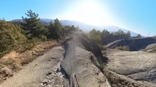
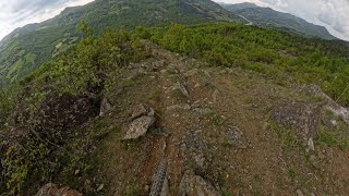
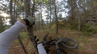
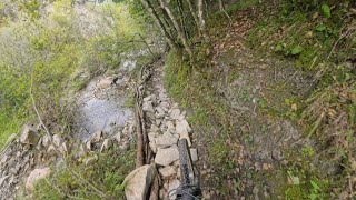
Popular Piacenza Mountain Biking Trails
• 90 ★ 4.8 • 1 mile • 14 ft • 65 •
Popular blue difficulty singletrack. This mountain bike primary trail can be used downhill only and has a easy overall physical rating. On average it takes 18 minutes to complete this trail.
• 100 ★ 5.0 • 2 miles • 49 ft • 57 •
Singletrack a tratti su fondo compatto a tratti friabile spesso stretto e talvolta esposto
• 90 ★ 5.0 • 3,560 ft • 0 ft • 52 •
Uno dei sentieri più recenti nella Bobbio-Coli Bike Area, inizia con una sessione nel bosco, dove la traccia segue l’andamento del terreno, con un’indole giocosa e fluida. Poi il sentiero esce dal bosco lasciando intravedere la...
• 75 ★ 4.7 • 4,639 ft • 0 ft • 50 •
Popular red difficulty singletrack. This mountain bike primary trail can be used downhill only and has a moderate overall physical rating. On average it takes 13 minutes to complete this trail.
• 90 ★ 5.0 • 4,987 ft • 0 ft • 47 •
Trail divertente che alterna tratti guidati a tratti più veloci.
• 95 ★ 5.0 • 1 mile • 0 ft • 45 •
Popular blue difficulty singletrack. This mountain bike primary trail can be used downhill only. On average it takes 13 minutes to complete this trail.
• 85 ★ 5.0 • 3,747 ft • 0 ft • 41 •
Un sentiero super panoramico che segue la cresta dei calanchi, dove è assolutamente vietato sbagliare! Ma l'incredibile ambiente e la vista unica ripagano ampiamente lo sforzo di rimanere concentrati sulla stretta lingua di terra che...
Piacenza Mountain Bike Routes
14 miles • 3,712 ft • 2 • Loop •
Bel giro con 2 discese e mezzo partendo dalla bassa, poi completa e dalla vetta del Monte .
13 miles • 2,201 ft • 1 • Loop •
Punti d’interesse: boschi della Rocca d’Olgisio, piana e sella di Monte Aldone Partendo da Pianello...
12 miles • 1,159 ft • 0 • Loop •
1-Anello del Brodo Punti d’interesse: le frazioni di Arcello e Case Gazzoli oltre a due bellissimi punti...
28 miles • 2,731 ft • 0 • Loop •
Giro che parte dalla chiesa di Vigolo Marchese e percorre strade secondarie e strade bianche. Nella prima...
17 miles • 2,465 ft • 0 • Loop •
Punti d’interesse: Chiarone, Monte Ciarello, Casa Fortificata l’Ardara(costa panoramico) Partendo da...
28 miles • 3,782 ft • 0 • Loop •
The first half is mixed road/dirt road climbing, with a couple of interesting slopes to have fun with....
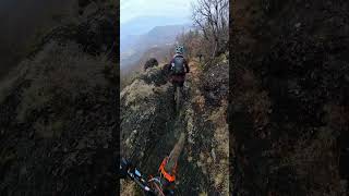
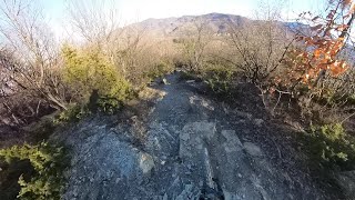
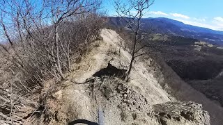
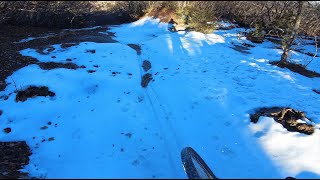
Photos of Piacenza Mountain Bike
Videos of Piacenza Mountain Bike
trail: Om Rus
0:02 |
68 |
Jan 23, 2026 , Bobbio
trail: Bramble
4:56 |
39 |
Sep 2, 2025 , My City
trail: DH Diavolo
5:37 |
55 |
Sep 2, 2025 , My City
trail: DH Diavolo
5:40 |
29 |
Sep 2, 2025 , My City
trail: Scabbia Fun
2:52 |
72 |
Sep 2, 2025 , Bobbio
trail: Pistino Armelio DH
11:41 |
102 |
Sep 2, 2025 , Bobbio
trail: PEVERI DH
5:52 |
71 |
Sep 2, 2025 , Bobbio
trail: Arturo dh
10:27 |
72 |
Sep 2, 2025 , Bobbio
Current Trail Warnings
| status | trail | date | condition | user | info |
|---|---|---|---|---|---|
| Anello Alto E-Bike Park Alta Val Tidone Outdoor Region | May 31, 2026 @ 8:55am (Europe/Rome) May 30, 2026 | Ideal | psole06 | E-Bike |
Recent Trail Reports
Activity Feed
| username | action | type | title | date |
|---|---|---|---|---|
| crushjz | add | report | activity #96946503 | Jun 14, 2026 @ 2:18am Jun 14, 2026 |
| crushjz | add | report | activity #96946502 and 2 more | Jun 14, 2026 @ 2:18am Jun 14, 2026 |
| MarcoRa21 | ridden | trail | activity #96599427 | Jun 9, 2026 @ 5:45am Jun 9, 2026 |
| lucaf7DIuP | vote | trail | activity #96473365 and 1 more | Jun 7, 2026 @ 10:00am Jun 7, 2026 |
| lucaf7DIuP | difficultyvote | trail | activity #96473080 and 1 more | Jun 7, 2026 @ 9:56am Jun 7, 2026 |
Recent Comments
| username | type | title | comment | date |
|---|---|---|---|---|
| trail | Prima parte con passaggi su rocce e poi nel... | Jan 10, 2026 @ 8:20am Jan 10, 2026 | ||
| trail | Sentiero enduro, partenza lunare fra le rocce,... | Jan 10, 2026 @ 8:05am Jan 10, 2026 | ||
| trail | Prima parte con qualche passaggio S3... | Jan 10, 2026 @ 8:00am Jan 10, 2026 | ||
| trail | Flow con qualche ripido non... | Nov 29, 2025 @ 8:31am Nov 29, 2025 | ||
| trail | Discesa che parte subito flow e tranquilla,... | Nov 29, 2025 @ 8:28am Nov 29, 2025 |
Local Badges
-

Completionist0 awarded -

10 Blue Trails13 awarded -

Epic Mountain Bike Climb 2k127 awarded -

Climbing 10k Badge14 awarded -

Mountain Biking 100k Badge4 awarded -

Big Ride 30k771 awarded
Bike & Skill Parks
| name | type | city | rating |
|---|---|---|---|
| Pumptruck | skill park | Bobbio |
Activity Type Stats
| activitytype | trails | distance | descent | descent distance | total vertical | rating | global rank | state rank | photos | reports | routes | ridelogs |
|---|---|---|---|---|---|---|---|---|---|---|---|---|
| Mountain Bike | 96 | 97 miles | 42,474 ft | 63 miles | 4,485 ft | 56 | 384 | 9 | 5,451 | |||
| E-Bike | 66 | 62 miles | 23,451 ft | 40 miles | 4,396 ft | 353 | 6 | 1,473 | ||||
| Horse | 10 | 20 miles | 2,405 ft | 11 miles | 2,096 ft | 18 | ||||||
| Hike | 77 | 81 miles | 31,355 ft | 49 miles | 4,485 ft | 359 | 2 | 218 | ||||
| Trail Running | 77 | 81 miles | 31,355 ft | 49 miles | 4,485 ft | 359 | 2 | 32 | ||||
| Dirtbike/Moto | 5 | 7 miles | 1,086 ft | 3 miles | 1,762 ft | 18 | 3 |
Frequently Asked Questions About Piacenza
▼
What are the best places to ride in Piacenza?
Piacenza has 7 areas to explore for mountain biking. The top rated areas are:
▼
What are the highest rated mountain biking trails in Piacenza?
The highest rated mountain biking trails in Piacenza are:
- PillerExpress (4.3/5)
- Pietra Trail (4.2/5)
- Pistino Armelio DH (4.2/5)
- La Rossa (4.2/5)
- Middle Super R-C (4.2/5)
▼
What is the best time of the year to ride in Piacenza?
Based on ride log data, the most popular months to ride in Piacenza are:
- September (17 activities)
- October (13 activities)
- April (11 activities)
▼
What is the longest trail in Piacenza?
The longest trail in Piacenza is Ciclovia del Trebbia - Rivergaro - Gossolengo at 8.3 miles. View all trails sorted by distance.
Activities
Trails
- By denitopia
 TRAILFORKS VTA & contributors
 - Admins: denitopia, marcoangeletti, cemoorelife
- #11671 - 4,949 views
- piacenza activity log | embed map of Piacenza mountain bike trails | piacenza mountain biking points of interest
Downloading of trail gps tracks in kml & gpx formats is enabled for Piacenza.
You must login to download files.