close
-
Layers w
- Weather Layers
- Pro
- Pro
- Pro
- Pro
- Pro
- Pro
- More Layers
- Pro
- Pro
- Pro
- Pro
-
Upgrade to

3D
Trail Conditions
- Unknown
- Snow Groomed
- Snow Packed
- Snow Covered
- Snow Cover Partial
- Freeze/thaw Cycle
- Icy
- Prevalent Mud
- Wet
- Variable
- Ideal
- Dry
- Very Dry
Trail Flow (Ridden Direction)
Trailforks scans users ridelogs to determine the most popular direction each trail is ridden. A good flowing trail network will have most trails flowing in a single direction according to their intension.
The colour categories are based on what percentage of riders are riding a trail in its intended direction.
The colour categories are based on what percentage of riders are riding a trail in its intended direction.
- > 96%
- > 90%
- > 80%
- > 70%
- > 50%
- < 50%
- bi-directional trail
- no data
Trail Last Ridden
Trailforks scans ridelogs to determine the last time a trail was ridden.
- < 2 days
- < 1 week
- < 2 weeks
- < 1 month
- < 6 months
- > 6 months
Trail Ridden Direction
The intended direction a trail should be ridden.
- Downhill Only
- Downhill Primary
- Both Directions
- Uphill Primary
- Uphill Only
- One Direction
Contribute Details
Colors indicate trail is missing specified detail.
- Description
- Photos
- Description & Photos
- Videos
Trail Popularity ?
Trailforks scans ridelogs to determine which trails are ridden the most in the last 9 months.
Trails are compared with nearby trails in the same city region with a possible 25 colour shades.
Think of this as a heatmap, more rides = more kinetic energy = warmer colors.
- most popular
- popular
- less popular
- not popular
ATV/ORV/OHV Filter
Max Vehicle Width
inches
US Cell Coverage
Legend

Radar Time
Activity Recordings
Trailforks uses anonymized public activity data.
?
Activity Recordings
Trailforks uses anonymized public activity data.
?
Personal Heatmap
▶
Activity Types
all
/
none
▶
Options
2
Date range
month
–
Winter Trails
Warning
A routing network for winter maps does not exist. Selecting trails using the winter trails layer has been disabled.
Missing Trails
Most Popular
Least Popular
Trails are colored based on popularity. The more popular a trail is, the more red. Less popular trails trend towards green.
Jump Magnitude Heatmap
Heatmap of where riders jump on trails. Zoom in to see individual jumps, click circles to view jump details.
BC Backroad Status
![map legend]()
Service Road Atlas is a free to use, community-driven service for viewing and creating reports on the numerous back-country service roads around B.C. and Alberta.

Slope Aspect
Direction the slope faces
Trails Deemphasized
Trails are shown in grey.
Only show trails with no bike usage.
Suggested Layers
Based on selected activity type
Save the current map location and zoom level as your default home location whenever this page is loaded.
Save
No description for Pikes Peak has been added yet!
Login or register to submit one.
 google parking directions
google parking directions Activities Click to view
- Mountain Bike
22 trails
- Hike
22 trails
- Trail Running
22 trails
Region Details
- 2
- 9
- 9
- 2
Region Status
Caution as of Jun 12, 2026Stats
- Avg Trail Rating
- Trails (view details)
- 22
- Trails Mountain Bike
- 22
- Trails Horse
- 1
- Trails Hike
- 22
- Trails Trail Running
- 22
- Total Distance
- 53 miles
- Total Descent
- 15,869 ft
- Total Vertical
- 7,622 ft
- Highest Trailhead
- 14,108 ft
- Reports
- 89
- Photos
- 79
- Ridden Counter
- 3,683
Popular Pikes Peak Mountain Biking Trails
• 60 ★ 3.4 • 5 miles • 354 ft • 537 •
Top of the world style ride with vast views of many valleys and some ripping downhill.
• 65 ★ 4.8 • 5 miles • 1,103 ft • 471 •
Old trail that has been made official. It used to be called "The ", but is now officially The Trail.
• 30 ★ 4.0 • 12 miles • 7,387 ft • 147 •
Some seriously gnarly sections of trail with several hike-a-bike sections over and around huge granite boulders. Popular with hikers, so check speed.
• 45 ★ 2.0 • 1 mile • 223 ft • 111 •
Moderately popular blue difficulty singletrack. This mountain bike primary trail can be used both directions. On average it takes 9 minutes to complete this trail.
• 45 ★ 2.7 • 1,744 ft • 232 ft • 103 •
Moderately popular black diamond difficulty singletrack. This mountain bike primary trail can be used both directions and has a moderate overall physical rating with a 232 ft blue climb. On average it takes 7 minutes to complete this trail.
• 40 ★ 0.0 • 2,519 ft • 52 ft • 99 • • hike
Moderately popular blue difficulty singletrack. This hike primary trail can be used both directions and has a moderate overall physical rating with a 52 ft blue climb. On average it takes 4 minutes to complete this trail.
• 35 ★ 4.3 • 3 miles • 654 ft • 55 •
Less popular black diamond difficulty singletrack. This mountain bike primary trail can be used downhill primary and has a hard overall physical rating with a 654 ft black diamond climb. Trail visibility is always easy to follow. On average it takes 51 minutes to complete this trail.
• 20 ★ 4.0 • 4 miles • 488 ft • 29 •
Less popular black diamond difficulty singletrack. This mountain bike primary trail can be used both directions and has a hard overall physical rating with a 488 ft black diamond climb. Trail visibility is always easy to follow. On average it takes 52 minutes to complete this trail.
Pikes Peak Mountain Bike Routes
★ 4.0 • 25 miles • 1,938 ft • 8 • Shuttled •
This very entertaining high elevation ride, starting above tree line and descending roughly 7000' through...
62 miles • 14,803 ft • 41 • Loop •
Approximately 60 mile loop that summits Pike's Peak. Starts and ends at the Red Rock Canyon Open Space....
20 miles • 823 ft • 0 • Point to Point •
This is a route down the West side of Pikes Peak through devil's playground. It then swings North through...
• 13 miles • 203 ft • 1 •
• 21 miles • 1,764 ft • 3 •
• 15 miles • 525 ft • 2 •
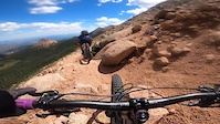
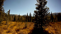
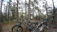
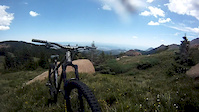
Photos of Pikes Peak Mountain Bike
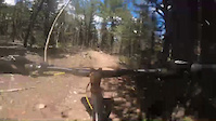
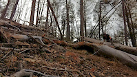
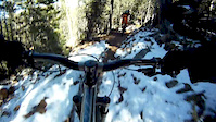
Videos of Pikes Peak Mountain Bike
trail: Elk Park
8:23 |
248 |
Oct 16, 2022
trail: Lake Moraine
0:44 |
20554 |
Jun 6, 2021
trail: Heizer
0:06 |
61 |
Oct 27, 2018

trail: Heizer
0:06 |
32 |
Oct 27, 2018
trail: Lake Moraine
0:18 |
488 |
Oct 14, 2018
trail: Lake Moraine
9:43 |
126 |
Oct 14, 2018
trail: Heizer
7:14 |
256 |
Aug 21, 2018
trail: Elk Park
8:49 |
512 |
Jul 30, 2017
Recent Trail Reports
| status | trail | date | condition | info | user |
|---|---|---|---|---|---|
| Elk Park | Jun 12, 2026 @ 12:47pm (America/Denver) Jun 12, 2026 | Dry | dashraces | ||
| Eagles Nest | Apr 28, 2026 @ 12:07pm (America/Denver) Apr 28, 2026 | Dry | dashraces | ||
| Barr Access | Oct 18, 2024 @ 1:54pm Oct 18, 2024 | Dry | dashraces | ||
| Lake Moraine | Aug 17, 2024 @ 8:23am Aug 17, 2024 | Dry | fly-navy | ||
| Mountain View | Jun 13, 2024 @ 4:27am Jun 13, 2024 | Unknown | OtisX | ||
| Intemann (West) | Jul 17, 2023 @ 4:55am Jul 17, 2023 | Dry | fly-navy | ||
| Barr Trail Uphill | Oct 16, 2022 @ 11:24am Oct 16, 2022 | Dry | mcom85 | ||
| Cabin Creek | Feb 14, 2020 @ 6:28am Feb 14, 2020 | Snow Covered | mtbaddict420 | ||
| Bottomless Pit | Feb 14, 2020 @ 6:28am Feb 14, 2020 | Snow Covered | mtbaddict420 | ||
| French Creek | Dec 17, 2019 @ 6:26am Dec 17, 2019 | Snow Packed | mtbaddict420 |
Activity Feed
| username | action | type | title | date |
|---|---|---|---|---|
| dashraces | add | report | activity #96935066 | Jun 13, 2026 @ 7:45pm Jun 13, 2026 |
| beady927 | vote | trail | activity #96431701 | Jun 6, 2026 @ 10:42pm Jun 6, 2026 |
| dfritton | add | photo | activity #96338356 | Jun 5, 2026 @ 7:33pm Jun 5, 2026 |
| gfg66 | ridden | trail | activity #96251821 | Jun 4, 2026 @ 2:21pm Jun 4, 2026 |
| mmesmer | wishlist | trail | activity #96241741 | Jun 4, 2026 @ 11:26am Jun 4, 2026 |
Recent Comments
| username | type | title | comment | date |
|---|---|---|---|---|
| trail | Not a public trail. Has no trespassing signs... | Jun 27, 2023 @ 3:02pm Jun 27, 2023 | ||
| trail | Trail is closed | Jun 27, 2023 @ 3:02pm Jun 27, 2023 | ||
| trail | NOT ACCESSIBLE FROM HIGHWAY 24 :( | Aug 20, 2022 @ 4:49pm Aug 20, 2022 | ||
| trail | Rode entire Barr Trail top to bottom 6/20/22.... | Jun 21, 2022 @ 10:29am Jun 21, 2022 | ||
| trail | First Half mile is def hike a bike. After that... | Jul 29, 2021 @ 3:06pm Jul 29, 2021 |
Nearby Areas
| name | distance | ||||
|---|---|---|---|---|---|
| North Catamount Reservoir | 1 | 5 | 1 | 5.8 km | |
| Red Rock Canyon Open Space | 21 | 32 | 4 | 1 | 6 km |
| Garden of the Gods Park | 6 | 5 | 6.3 km | ||
| Catamount Reservoir | 1 | 8 | 1 | 6.8 km | |
| North Cheyenne Cañon Park | 3 | 15 | 11 | 1 | 7.1 km |
Local Badges
-

Completionist0 awarded
Activity Type Stats
| activitytype | trails | distance | descent | descent distance | total vertical | rating | global rank | state rank | photos | reports | routes | ridelogs |
|---|---|---|---|---|---|---|---|---|---|---|---|---|
| Mountain Bike | 22 | 53 miles | 15,869 ft | 26 miles | 7,621 ft | #3,800 | #1,317 | 80 | 89 | 3 | 704 | |
| Horse | 1 | 6 miles | 3,960 ft | 5 miles | 3,917 ft | 17 | 1 | |||||
| Hike | 22 | 53 miles | 15,869 ft | 26 miles | 7,621 ft | #664 | #348 | 89 | 2 | 731 | ||
| Trail Running | 22 | 53 miles | 15,869 ft | 26 miles | 7,621 ft | #3,101 | #816 | 89 | 1 | 545 |
Frequently Asked Questions About Pikes Peak
▼
What are the highest rated mountain biking trails in Pikes Peak?
The highest rated mountain biking trails in Pikes Peak are:
- Lake Moraine (4.4/5)
- Waldo Canyon (4.1/5)
- Eagles Nest (4.1/5)
- Heizer (4.1/5)
- Barr Trail Uphill (4/5)
▼
What is the best time of the year to ride in Pikes Peak?
Based on ride log data, the most popular months to ride in Pikes Peak are:
- August (11 activities)
- June (10 activities)
- July (9 activities)
▼
Where can I park to ride in Pikes Peak?
There are 3 parking locations listed in Pikes Peak. The most popular parking spots are: View all parking and trailhead locations on the map to plan your visit.
▼
What is the longest trail in Pikes Peak?
The longest trail in Pikes Peak is Barr Trail Uphill at 11.7 miles. View all trails sorted by distance.
Activities
Trails
Points of Interest
- By brenthillier
 NSMBA TRAILFORKS & contributors
 - Admins: MWTA, COSMBA
- #3911 - 15,175 views
- pikes peak activity log | embed map of Pikes Peak mountain bike trails | pikes peak mountain biking points of interest
Downloading of trail gps tracks in kml & gpx formats is enabled for Pikes Peak.
You must login to download files.