close
-
Layers w
- Weather Layers
- Pro
- Pro
- Pro
- Pro
- Pro
- Pro
- More Layers
- Pro
- Pro
- Pro
- Pro
-
Upgrade to

3D
Trail Conditions
- Unknown
- Snow Groomed
- Snow Packed
- Snow Covered
- Snow Cover Partial
- Freeze/thaw Cycle
- Icy
- Prevalent Mud
- Wet
- Variable
- Ideal
- Dry
- Very Dry
Trail Flow (Ridden Direction)
Trailforks scans users ridelogs to determine the most popular direction each trail is ridden. A good flowing trail network will have most trails flowing in a single direction according to their intension.
The colour categories are based on what percentage of riders are riding a trail in its intended direction.
The colour categories are based on what percentage of riders are riding a trail in its intended direction.
- > 96%
- > 90%
- > 80%
- > 70%
- > 50%
- < 50%
- bi-directional trail
- no data
Trail Last Ridden
Trailforks scans ridelogs to determine the last time a trail was ridden.
- < 2 days
- < 1 week
- < 2 weeks
- < 1 month
- < 6 months
- > 6 months
Trail Ridden Direction
The intended direction a trail should be ridden.
- Downhill Only
- Downhill Primary
- Both Directions
- Uphill Primary
- Uphill Only
- One Direction
Contribute Details
Colors indicate trail is missing specified detail.
- Description
- Photos
- Description & Photos
- Videos
Trail Popularity ?
Trailforks scans ridelogs to determine which trails are ridden the most in the last 9 months.
Trails are compared with nearby trails in the same city region with a possible 25 colour shades.
Think of this as a heatmap, more rides = more kinetic energy = warmer colors.
- most popular
- popular
- less popular
- not popular
ATV/ORV/OHV Filter
Max Vehicle Width
inches
US Cell Coverage
Legend

Radar Time
Activity Recordings
Trailforks uses anonymized public activity data.
?
Activity Recordings
Trailforks uses anonymized public activity data.
?
Personal Heatmap
▶
Activity Types
all
/
none
▶
Options
2
Date range
month
–
Winter Trails
Warning
A routing network for winter maps does not exist. Selecting trails using the winter trails layer has been disabled.
Missing Trails
Most Popular
Least Popular
Trails are colored based on popularity. The more popular a trail is, the more red. Less popular trails trend towards green.
Jump Magnitude Heatmap
Heatmap of where riders jump on trails. Zoom in to see individual jumps, click circles to view jump details.
BC Backroad Status
![map legend]()
Service Road Atlas is a free to use, community-driven service for viewing and creating reports on the numerous back-country service roads around B.C. and Alberta.

Slope Aspect
Direction the slope faces
Trails Deemphasized
Trails are shown in grey.
Only show trails with no bike usage.
Suggested Layers
Based on selected activity type
Save the current map location and zoom level as your default home location whenever this page is loaded.
SaveGenerally handdug/hand maintained trails. Some access issues, be mindful of hikers and horsepeople (centaurs). Most climbs are of the paved/fireroad variety, most descents are a mix of loose rock, fixed rock, and good dirt. Gets dry in the summer. High elevation trails are clear May-October, bring plenty of water.
Primary Trail Type: All-Mountain & Downhill
Shuttleable: YES
Land Status: National Forest
 google parking directions
 Activities Click to view
- Mountain Bike
52 trails
- E-Bike
20 trails
- Horse
45 trails
- Hike
62 trails
- Trail Running
62 trails
- Dirtbike/Moto
17 trails
- ATV/ORV/OHV
17 trails
Region Details
- 23
- 3
- 18
- 6
Region Status
Caution as of 4 hoursStats
- Avg Trail Rating
- Trails (view details)
- 61
- Trails Mountain Bike
- 52
- Trails E-Bike
- 20
- Trails Gravel Bike
- 1
- Trails Horse
- 45
- Trails Hike
- 62
- Trails Trail Running
- 62
- Trails Dirtbike/Moto
- 17
- Trails ATV/ORV/OHV
- 17
- Total Distance
- 144 miles
- Total Descent
- 20,744 ft
- Total Vertical
- 4,455 ft
- Highest Trailhead
- 9,321 ft
- Reports
- 100
- Photos
- 72
- Ridden Counter
- 6,086
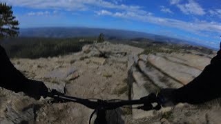
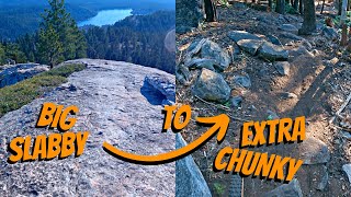
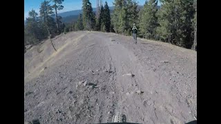
Popular Pinecrest Mountain Biking Trails
• 95 ★ 5.0 • 2 miles • 2 ft • 183 •
Popular black diamond difficulty alpine singletrack. This mountain bike primary trail can be used downhill primary and has a hard overall physical rating with a 2 ft black diamond climb. It features rock face and rock garden. Trail visibility is sometimes hard to follow. On average it takes 26 minutes to complete this trail.
• 100 ★ 5.0 • 1 mile • 0 ft • 173 •
Popular black diamond difficulty alpine singletrack. This mountain bike primary trail can be used downhill primary and has a hard overall physical rating with a 0 ft black diamond climb. Trail visibility is sometimes hard to follow. On average it takes 11 minutes to complete this trail.
• 100 ★ 5.0 • 1 mile • 14 ft • 172 •
Connector trail to bypass hiking-only Pinecrest Lake Trail
• 100 ★ 0.0 • 1,181 ft • 9 ft • 166 •
Popular blue difficulty singletrack. This multi-use trail can be used downhill primary and has a moderate overall physical rating with a 9 ft blue climb. Trail visibility is always easy to follow. On average it takes 4 minutes to complete this trail.
• 85 ★ 4.8 • 3 miles • 75 ft • 95 •
, known locally as Strawberry Branch trail, is a beautiful trail along the South Fork of the Stanislaus river. The top starts as a double track dropping you down to an old railroad grade that follows the river. Popular with both hikers...
• 80 ★ 4.4 • 3 miles • 681 ft • 22 •
Known locally as South Fork trail. This trail is usually ridden in the downhill direction starting at Old Strawberry Rd and ending at Fraser Flat Rd/4N01. The top section is a single track mostly following an abandoned canal, but with a...
• 55 ★ 5.0 • 4 miles • 16 ft • 20 •
This trail is actually known as the Hammill Canyon Trail. It is primarily ridden east to west, but you can ride it west to east with a fair amount of hiking. Much of the trail is easy dirt cruising, but there are some rocky sections to...
Photos of Pinecrest Mountain Bike
Videos of Pinecrest Mountain Bike

12:41 |
269 |
Dec 2, 2023 , Pinecrest

12:41 |
200 |
Dec 2, 2023 , Pinecrest
12:41 |
167 |
Dec 2, 2023 , Pinecrest
20:25 |
543 |
Feb 6, 2023 , Pinecrest
23:25 |
498 |
Nov 6, 2018 , Pinecrest
15:35 |
156 |
Nov 7, 2024 , Pinecrest
Current Trail Warnings
| status | trail | date | condition | user | info |
|---|---|---|---|---|---|
| Lupine Dirt Rd | May 26, 2026 @ 3:29pm (America/Los_Angeles) May 26, 2026 | Ideal | joedirt209 | Multiple trees down |
Recent Trail Reports
Activity Feed
| username | action | type | title | date |
|---|---|---|---|---|
| thomasjkenney1024 | vote | trail | activity #97227461 | Jun 17, 2026 @ 7:43pm 4 hours |
| thomasjkenney1024 | add | report | activity #97227446 | Jun 17, 2026 @ 7:43pm 4 hours |
| thomasjkenney1024 | add | photo | activity #97227154 and 9 more | Jun 17, 2026 @ 7:37pm 4 hours |
| thomasjkenney1024 | vote | trail | activity #96714091 | Jun 10, 2026 @ 7:44pm Jun 10, 2026 |
| thomasjkenney1024 | add | photo | activity #96713894 and 6 more | Jun 10, 2026 @ 7:40pm Jun 10, 2026 |
Recent Comments
| username | type | title | comment | date |
|---|---|---|---|---|
| trail | This is a great climb, lots of variety and... | Jun 3, 2026 @ 8:46pm Jun 3, 2026 | ||
| trail | I really dig this one! Very wild, lots of... | Jun 3, 2026 @ 8:44pm Jun 3, 2026 | ||
| trail | Mostly a fire road but narrows to single track... | Aug 10, 2025 @ 2:17pm Aug 10, 2025 | ||
| trail | This is a horse trail. Covered in deep silt... | Jul 10, 2025 @ 6:41pm Jul 10, 2025 | ||
| trail | If you haven't done this consider yourself... | Jul 10, 2025 @ 6:38pm Jul 10, 2025 |
Nearby Areas
| name | distance | ||||
|---|---|---|---|---|---|
| Dodge Ridge Mountain Resort | 1 | 3 | 1 | 2 | 2.7 km |
| Stanislaus National Forest | 3 | 1 | 4.7 km | ||
| Lyons Reservoir | 5 | 3 | 12.4 km | ||
| Calaveras Big Trees State Park | 16.4 km | ||||
| Bear Valley Resort | 3 | 3 | 2 | 20.6 km |
Local Badges
-

Completionist0 awarded
Activity Type Stats
| activitytype | trails | distance | descent | descent distance | total vertical | rating | global rank | state rank | photos | reports | routes | ridelogs |
|---|---|---|---|---|---|---|---|---|---|---|---|---|
| Mountain Bike | 52 | 96 miles | 14,751 ft | 46 miles | 4,455 ft | #2,166 | #735 | 58 | 99 | 3,197 | ||
| E-Bike | 20 | 52 miles | 6,975 ft | 24 miles | 3,438 ft | #2,869 | #898 | 69 | 703 | |||
| Gravel Bike | 1 | #7,487 | #3,158 | 89 | ||||||||
| Horse | 45 | 117 miles | 17,224 ft | 54 miles | 4,216 ft | #198 | #232 | 31 | ||||
| Hike | 62 | 143 miles | 20,443 ft | 64 miles | 4,455 ft | #605 | #323 | 14 | 96 | 4 | 601 | |
| Trail Running | 62 | 143 miles | 20,443 ft | 64 miles | 4,455 ft | #696 | #254 | 96 | 3 | 74 | ||
| Dirtbike/Moto | 17 | 51 miles | 6,772 ft | 24 miles | 3,399 ft | #589 | #183 | 16 | 1 | |||
| ATV/ORV/OHV | 17 | 51 miles | 6,772 ft | 24 miles | 3,399 ft | #382 | #101 | 16 | 1 |
Frequently Asked Questions About Pinecrest
▼
What are the highest rated mountain biking trails in Pinecrest?
The highest rated mountain biking trails in Pinecrest are:
- Pinecrest Peak (Upper Section) (4.4/5)
- Sugar Pine Railway (4.3/5)
- Herring Creek Trail (4.2/5)
- Crabtree Lower (4.2/5)
- Eagle Peak Trail (4.1/5)
▼
What is the best time of the year to ride in Pinecrest?
Based on ride log data, the most popular months to ride in Pinecrest are:
- July (77 activities)
- August (63 activities)
- June (42 activities)
▼
Where can I park to ride in Pinecrest?
There are 3 parking locations listed in Pinecrest. The most popular parking spots are: View all parking and trailhead locations on the map to plan your visit.
▼
What is the longest trail in Pinecrest?
The longest trail in Pinecrest is Herring Creek Trail at 4.4 miles. View all trails sorted by distance.
Activities
Trails
Points of Interest
- By oranso & contributors
- Admins: PMBA
- #14384 - 8,751 views
- pinecrest activity log | embed map of Pinecrest mountain bike trails | pinecrest mountain biking points of interest
Downloading of trail gps tracks in kml & gpx formats is enabled for Pinecrest.
You must login to download files.