close
-
Layers w
- Weather Layers
- Pro
- Pro
- Pro
- Pro
- Pro
- Pro
- More Layers
- Pro
- Pro
- Pro
- Pro
-
Upgrade to

3D
Trail Conditions
- Unknown
- Snow Groomed
- Snow Packed
- Snow Covered
- Snow Cover Partial
- Freeze/thaw Cycle
- Icy
- Prevalent Mud
- Wet
- Variable
- Ideal
- Dry
- Very Dry
Trail Flow (Ridden Direction)
Trailforks scans users ridelogs to determine the most popular direction each trail is ridden. A good flowing trail network will have most trails flowing in a single direction according to their intension.
The colour categories are based on what percentage of riders are riding a trail in its intended direction.
The colour categories are based on what percentage of riders are riding a trail in its intended direction.
- > 96%
- > 90%
- > 80%
- > 70%
- > 50%
- < 50%
- bi-directional trail
- no data
Trail Last Ridden
Trailforks scans ridelogs to determine the last time a trail was ridden.
- < 2 days
- < 1 week
- < 2 weeks
- < 1 month
- < 6 months
- > 6 months
Trail Ridden Direction
The intended direction a trail should be ridden.
- Downhill Only
- Downhill Primary
- Both Directions
- Uphill Primary
- Uphill Only
- One Direction
Contribute Details
Colors indicate trail is missing specified detail.
- Description
- Photos
- Description & Photos
- Videos
Trail Popularity ?
Trailforks scans ridelogs to determine which trails are ridden the most in the last 9 months.
Trails are compared with nearby trails in the same city region with a possible 25 colour shades.
Think of this as a heatmap, more rides = more kinetic energy = warmer colors.
- most popular
- popular
- less popular
- not popular
ATV/ORV/OHV Filter
Max Vehicle Width
inches
US Cell Coverage
Legend

Radar Time
Activity Recordings
Trailforks uses anonymized public activity data.
?
Activity Recordings
Trailforks uses anonymized public activity data.
?
Personal Heatmap
▶
Activity Types
all
/
none
▶
Options
2
Date range
month
–
Winter Trails
Warning
A routing network for winter maps does not exist. Selecting trails using the winter trails layer has been disabled.
Missing Trails
Most Popular
Least Popular
Trails are colored based on popularity. The more popular a trail is, the more red. Less popular trails trend towards green.
Jump Magnitude Heatmap
Heatmap of where riders jump on trails. Zoom in to see individual jumps, click circles to view jump details.
BC Backroad Status
![map legend]()
Service Road Atlas is a free to use, community-driven service for viewing and creating reports on the numerous back-country service roads around B.C. and Alberta.

Slope Aspect
Direction the slope faces
Trails Deemphasized
Trails are shown in grey.
Only show trails with no bike usage.
Suggested Layers
Based on selected activity type
Save the current map location and zoom level as your default home location whenever this page is loaded.
Save
No description for Pinetop-Lakeside has been added yet!
Login or register to submit one.
Activities Click to view
- Mountain Bike
78 trails
- Gravel Bike
0 trails
- Adaptive Bike
0 trails
- Winter Fat Bike
0 trails
- Horse
72 trails
- Hike
76 trails
- Trail Running
76 trails
- Dirtbike/Moto
5 trails
- ATV/ORV/OHV
4 trails
Region Details
- 14
- 26
- 23
- 14
- 1
Region Status
Open as of Jun 19, 2026Stats
- Avg Trail Rating
- Trails (view details)
- 80
- Trails Mountain Bike
- 78
- Trails Horse
- 72
- Trails Hike
- 76
- Trails Trail Running
- 76
- Trails Dirtbike/Moto
- 5
- Trails ATV/ORV/OHV
- 4
- Total Distance
- 351 miles
- Total Descent
- 26,249 ft
- Total Vertical
- 2,569 ft
- Highest Trailhead
- 8,482 ft
- Reports
- 364
- Photos
- 167
- Ridden Counter
- 5,407
Articles
Race Report: 2024 Epic Rides Tour of the White Mountains
Oct 9, 2024 from pinkbike.com
The Juniors dominated.
Sub Regions
-
White Mountain Trail System
- 24
- 22
- 14
- 1
-
Woodland Lake Park
- 2
Popular Pinetop-Lakeside Mountain Biking Trails
• 100 ★ 2.0 • 2 miles • 36 ft • 724 •
Popular green difficulty singletrack. This multi-use trail can be used both directions and has a moderate overall physical rating with a 36 ft green climb. On average it takes 9 minutes to complete this trail.
• 100 ★ 3.8 • 3 miles • 208 ft • 693 •
is a short loop near Pinetop and one of the technically-easier trails in the White Mountain trail system maintained by TRACKS. TRACKS has info here: http://www.tracks-pinetop-lakeside.org/
• 100 ★ 3.0 • 1 mile • 40 ft • 688 •
Popular green difficulty singletrack. This multi-use trail can be used both directions and has a easy overall physical rating with a 40 ft green climb. On average it takes 6 minutes to complete this trail.
• 95 ★ 3.2 • 7 miles • 52 ft • 594 •
is a TRACKS connector trail from on the West side to on the East. Sections of this trail are full of baby-head rocks but the line is cleaned up for the Tour of the White Mountains race every fall. More info at:...
• 90 ★ 3.5 • 2 miles • 418 ft • 264 •
Popular blue difficulty singletrack. This multi-use trail can be used both directions and has a moderate overall physical rating with a 418 ft blue climb. On average it takes 21 minutes to complete this trail.
• 80 ★ 4.5 • 13 miles • 1,217 ft • 257 •
This is one of the more popular trails in the White Mountain trail system. Usually ridden counter-clockwise from the campground though there two more trailheads a little Northeast. Reservation Flats tends to stay muddy for a day or two...
Pinetop-Lakeside Mountain Bike Routes
★ 5.0 • 53 miles • 3,615 ft • 4 •
With great cooperation from the Apache-Sitgreaves National Forests, T.R.A.C.K.S. the communities of...
★ 3.0 • 9 miles • 741 ft • 1 • Loop •
4 miles • 408 ft • 1 • Out & Back •
3 miles • 156 ft • 2 • Loop •
9 miles • 664 ft • 2 • Loop •
★ 3.0 • 9 miles • 707 ft • 0 • Loop •
Photos of Pinetop-Lakeside Mountain Bike
Videos of Pinetop-Lakeside Mountain Bike
trail: Chipmunk Springs
0:09 |
355 |
Aug 15, 2021

trail: Los Burros
13:00 |
1492 |
Dec 31, 2020 , Pinetop-Lakeside

trail: Ghost of the Coyotes South
7:40 |
552 |
Sep 26, 2018 , Pinetop-Lakeside
trail: Ghost of the Coyotes North
7:40 |
427 |
Sep 26, 2018 , Pinetop-Lakeside
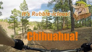
trail: Chihuahua
15:02 |
642 |
Sep 1, 2018 , Pinetop-Lakeside

trail: Chipmunk Springs
2:57 |
1347 |
Aug 12, 2018 , Pinetop-Lakeside
trail: Los Burros Shortcut
2:48 |
288 |
Jul 25, 2018 , Pinetop-Lakeside

trail: Chipmunk Springs
2:48 |
931 |
Jul 25, 2018 , Pinetop-Lakeside
Recent Trail Reports
| status | trail | date | condition | info | user |
|---|---|---|---|---|---|
| Turkey Track Loop Trail | Jun 19, 2026 @ 9:51am (America/Phoenix) Jun 19, 2026 | Ideal | Mangosmoothie | ||
| Woodland Lake | Jun 19, 2026 @ 9:51am (America/Phoenix) Jun 19, 2026 | Ideal | Mangosmoothie | ||
| Panorama | Jun 6, 2026 @ 4:48pm (America/Phoenix) Jun 6, 2026 | Dry | pniemczyk | ||
| Panorama | Jun 6, 2026 @ 4:48pm (America/Phoenix) Jun 6, 2026 | Dry | pniemczyk | ||
| Los Burros Access | May 18, 2026 @ 9:36am (America/Phoenix) May 18, 2026 | Ideal | hikinglaur | ||
| Juniper Ridge | May 16, 2026 @ 2:56pm (America/Phoenix) May 16, 2026 | Variable | NikitanvRzE | ||
| Los Burros Shortcut | Mar 25, 2026 @ 7:51pm (America/Phoenix) Mar 25, 2026 | Unknown | 7mDCnwqx | ||
| Chipmunk Springs | Mar 14, 2026 @ 5:42pm (America/Phoenix) Mar 14, 2026 | Dry | Austinmacey | ||
| Mark Twain | Oct 4, 2025 @ 8:29am (America/Phoenix) Oct 4, 2025 | Ideal | manny-g | ||
| Iron Horse | Oct 4, 2025 @ 8:29am (America/Phoenix) Oct 4, 2025 | Dry | manny-g |
Activity Feed
| username | action | type | title | date |
|---|---|---|---|---|
| MarkPxofWH | wishlist | trail | activity #97487037 | Jun 21, 2026 @ 8:21am Jun 21, 2026 |
| Mangosmoothie | add | report | activity #97331626 | Jun 19, 2026 @ 11:10am Jun 19, 2026 |
| Mangosmoothie | add | report | activity #97331530 and 1 more | Jun 19, 2026 @ 11:09am Jun 19, 2026 |
| ownyourtime | ridden | trail | activity #97317877 | Jun 19, 2026 @ 8:00am Jun 19, 2026 |
| TazMTBr | ridden | trail | activity #96905939 | Jun 13, 2026 @ 12:30pm Jun 13, 2026 |
Recent Comments
| username | type | title | comment | date |
|---|---|---|---|---|
| trail | We rode CCW today and had a great ride. It is... | Mar 25, 2026 @ 12:12pm Mar 25, 2026 | ||
| trail | This is an ATV trail. If you are looking to... | Mar 25, 2026 @ 8:10am Mar 25, 2026 | ||
| trail | Decent descent, could use some trail... | Sep 1, 2025 @ 10:22am Sep 1, 2025 | ||
| trail | The first part of the trail has a challenging... | Sep 1, 2025 @ 10:20am Sep 1, 2025 | ||
| trail | Fun trail. Does have some small obstacles(log... | Sep 1, 2025 @ 10:19am Sep 1, 2025 |
Local Badges
-

Epic Ride Climb 2k10 awarded -

Climbing 10k Badge14 awarded -

Climbing 100k Badge0 awarded -

Epic Ride Descent 2k72 awarded -

Descent 10k Badge22 awarded -

Descent 100k Badge0 awarded
Bike & Skill Parks
| name | type | city | rating |
|---|---|---|---|
| Thunder Raceway | skill park | Pinetop-Lakeside |
Activity Type Stats
| activitytype | trails | distance | descent | descent distance | total vertical | rating | global rank | state rank | photos | reports | routes | ridelogs |
|---|---|---|---|---|---|---|---|---|---|---|---|---|
| Mountain Bike | 78 | 333 miles | 24,895 ft | 154 miles | 2,569 ft | #825 | #321 | 159 | 364 | 8 | 4,659 | |
| Horse | 72 | 304 miles | 23,648 ft | 143 miles | 2,251 ft | #75 | #355 | 143 | 2 | 3 | ||
| Hike | 76 | 310 miles | 23,957 ft | 145 miles | 2,251 ft | #366 | #174 | 8 | 362 | 7 | 631 | |
| Trail Running | 76 | 310 miles | 23,957 ft | 145 miles | 2,251 ft | #471 | #183 | 362 | 6 | 90 | ||
| Dirtbike/Moto | 5 | 50 miles | 2,654 ft | 23 miles | 1,089 ft | #683 | #235 | 56 | 5 | |||
| ATV/ORV/OHV | 4 | 41 miles | 2,293 ft | 19 miles | 1,083 ft | #553 | #203 | 56 | 11 |
Frequently Asked Questions About Pinetop-Lakeside
▼
What are the best places to ride in Pinetop-Lakeside?
Pinetop-Lakeside has 2 areas to explore for mountain biking. The top rated areas are:
▼
What are the highest rated mountain biking trails in Pinetop-Lakeside?
The highest rated mountain biking trails in Pinetop-Lakeside are:
- Los Burros (4.4/5)
- Blue Ridge Mountain (4.1/5)
- El Acceso (4.1/5)
- Sawmill Connector (4.1/5)
- Heber Hollow (4.1/5)
▼
What is the best time of the year to ride in Pinetop-Lakeside?
Based on ride log data, the most popular months to ride in Pinetop-Lakeside are:
- July (38 activities)
- September (31 activities)
- October (26 activities)
▼
Where can I park to ride in Pinetop-Lakeside?
There are 15 parking locations listed in Pinetop-Lakeside. The most popular parking spots are: View all parking and trailhead locations on the map to plan your visit.
Activities
Trails
- By Schwinnshralper26
 & contributors
 - Admins: apply
- #6017 - 12,023 views
- pinetop-lakeside activity log | embed map of Pinetop-Lakeside mountain bike trails | pinetop-lakeside mountain biking points of interest
Downloading of trail gps tracks in kml & gpx formats is enabled for Pinetop-Lakeside.
You must login to download files.