close
-
Layers w
- Weather Layers
- Pro
- Pro
- Pro
- Pro
- Pro
- Pro
- More Layers
- Pro
- Pro
- Pro
- Pro
-
Upgrade to

3D
Trail Conditions
- Unknown
- Snow Groomed
- Snow Packed
- Snow Covered
- Snow Cover Partial
- Freeze/thaw Cycle
- Icy
- Prevalent Mud
- Wet
- Variable
- Ideal
- Dry
- Very Dry
Trail Flow (Ridden Direction)
Trailforks scans users ridelogs to determine the most popular direction each trail is ridden. A good flowing trail network will have most trails flowing in a single direction according to their intension.
The colour categories are based on what percentage of riders are riding a trail in its intended direction.
The colour categories are based on what percentage of riders are riding a trail in its intended direction.
- > 96%
- > 90%
- > 80%
- > 70%
- > 50%
- < 50%
- bi-directional trail
- no data
Trail Last Ridden
Trailforks scans ridelogs to determine the last time a trail was ridden.
- < 2 days
- < 1 week
- < 2 weeks
- < 1 month
- < 6 months
- > 6 months
Trail Ridden Direction
The intended direction a trail should be ridden.
- Downhill Only
- Downhill Primary
- Both Directions
- Uphill Primary
- Uphill Only
- One Direction
Contribute Details
Colors indicate trail is missing specified detail.
- Description
- Photos
- Description & Photos
- Videos
Trail Popularity ?
Trailforks scans ridelogs to determine which trails are ridden the most in the last 9 months.
Trails are compared with nearby trails in the same city region with a possible 25 colour shades.
Think of this as a heatmap, more rides = more kinetic energy = warmer colors.
- most popular
- popular
- less popular
- not popular
ATV/ORV/OHV Filter
Max Vehicle Width
inches
US Cell Coverage
Legend

Radar Time
Activity Recordings
Trailforks uses anonymized public activity data.
?
Activity Recordings
Trailforks uses anonymized public activity data.
?
Personal Heatmap
▶
Activity Types
all
/
none
▶
Options
2
Date range
month
–
Winter Trails
Warning
A routing network for winter maps does not exist. Selecting trails using the winter trails layer has been disabled.
Missing Trails
Most Popular
Least Popular
Trails are colored based on popularity. The more popular a trail is, the more red. Less popular trails trend towards green.
Jump Magnitude Heatmap
Heatmap of where riders jump on trails. Zoom in to see individual jumps, click circles to view jump details.
BC Backroad Status
![map legend]()
Service Road Atlas is a free to use, community-driven service for viewing and creating reports on the numerous back-country service roads around B.C. and Alberta.

Slope Aspect
Direction the slope faces
Trails Deemphasized
Trails are shown in grey.
Only show trails with no bike usage.
Suggested Layers
Based on selected activity type
Save the current map location and zoom level as your default home location whenever this page is loaded.
Save
No description for Pingtung has been added yet!
Login or register to submit one.
Activities Click to view
- Mountain Bike
6 trails
- Gravel Bike
0 trails
- Adaptive Bike
0 trails
- Hike
13 trails
- Trail Running
6 trails
Region Details
- 1
- 4
- 1
Region Status
Open as of Feb 16, 2026Stats
- Avg Trail Rating
- Trails (view details)
- 6
- Trails Mountain Bike
- 6
- Trails E-Bike
- 3
- Trails Hike
- 13
- Trails Trail Running
- 6
- Total Distance
- 29 miles
- Total Descent
- 13,352 ft
- Total Vertical
- 4,858 ft
- Highest Trailhead
- 4,939 ft
- Reports
- 7
- Photos
- 36
- Ridden Counter
- 90
Popular Pingtung Mountain Biking Trails
• 70 ★ 0.0 • 3,642 ft • 328 ft • 20 •
Popular blue difficulty singletrack. This mountain bike primary trail can be used both directions and has a hard overall physical rating with a 328 ft blue climb. Trail visibility is sometimes hard to follow. On average it takes 18 minutes to complete this trail.
• 35 ★ 0.0 • 9 miles • 1,632 ft • 10 •
Entrance certificate for "hiking" is compulsory for this trail. This is a popular hiking trail. Share the trails with hikers especially during weekend and holiday. The 1st 4-5km is rocky, rooty and ultra slippery on log. Few zip zap...
• 50 ★ 0.0 • 6 miles • 807 ft • 4 •
蜘蛛網,芒草及矮灌木叢茂盛,建議戴全罩、風鏡、長袖、長褲。 當地獵人及越野摩托車經常性出現,尤其是假日,盲彎處須減速注意聽是否有引擎聲逆向而來。...
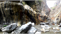
Photos of Pingtung Mountain Bike
Videos of Pingtung Mountain Bike
trail: 哈尤溪溫泉
0:42 |
105 |
Mar 20, 2017
Recent Trail Reports
| status | trail | date | condition | info | user |
|---|---|---|---|---|---|
| 大山母山 | Apr 14, 2023 @ 4:54pm Apr 14, 2023 | Very Dry | Sam725 | ||
| 忠義坡 | Apr 14, 2023 @ 11:54pm Apr 14, 2023 | Very Dry | Sam725 | ||
| 浸水營古道 JinShueiYing Old Trail | Feb 26, 2022 @ 1:16pm Feb 26, 2022 | Wet | brianchiu |
Activity Feed
| username | action | type | title | date |
|---|---|---|---|---|
| BlairKzijoK | wishlist | trail | activity #87064861 | Jan 11, 2026 @ 10:59pm Jan 11, 2026 |
| thab | difficultyvote | trail | activity #73926053 | Jun 16, 2025 @ 12:50pm Jun 16, 2025 |
| thab | comment | trail | activity #73925904 | Jun 16, 2025 @ 12:47pm Jun 16, 2025 |
| toe_traveler | wishlist | trail | activity #63397508 and 2 more | Dec 22, 2024 @ 11:39pm Dec 22, 2024 |
| Changkn1mem | ridden | trail | activity #50916228 | Apr 7, 2024 @ 6:38pm Apr 7, 2024 |
Recent Comments
| username | type | title | comment | date |
|---|---|---|---|---|
| trail | picture wise it looks more like a green (max... | Jun 16, 2025 @ 12:47pm Jun 16, 2025 |
Activity Type Stats
| activitytype | trails | distance | descent | descent distance | total vertical | rating | global rank | state rank | photos | reports | routes | ridelogs |
|---|---|---|---|---|---|---|---|---|---|---|---|---|
| Mountain Bike | 6 | 29 miles | 13,353 ft | 16 miles | 4,859 ft | #1,788 | #4 | 36 | 7 | 617 | ||
| E-Bike | 3 | 8 miles | 4,062 ft | 5 miles | 2,877 ft | 7 | 27 | |||||
| Hike | 13 | 29 miles | 13,353 ft | 16 miles | 4,859 ft | #1,925 | #8 | 7 | 64 | |||
| Trail Running | 6 | 29 miles | 13,353 ft | 16 miles | 4,859 ft | #1,538 | #8 | 7 | 22 |
Frequently Asked Questions About Pingtung
▼
What are the highest rated mountain biking trails in Pingtung?
The highest rated mountain biking trails in Pingtung are:
- 石牛溪 (4.1/5)
- 大山母山 (4.1/5)
- 忠義坡 (0/5)
- 泰武林道-北線 (0/5)
- 浸水營古道 JinShueiYing Old Trail (0/5)
▼
What is the best time of the year to ride in Pingtung?
Based on ride log data, the most popular months to ride in Pingtung are:
- March (3 activities)
- April (2 activities)
- January (1 activities)
▼
Where can I park to ride in Pingtung?
Check the Pingtung trail map for trailhead and parking information. Community members regularly update access and parking details for trails in the area.
▼
What is the longest trail in Pingtung?
The longest trail in Pingtung is 浸水營古道 JinShueiYing Old Trail at 9.4 miles. View all trails sorted by distance.
Trails
Points of Interest
- By davieangel & contributors
- Admins: LRT, claudedore, davieangel
- #18062 - 2,167 views
- pingtung activity log | embed map of Pingtung mountain bike trails |
Downloading of trail gps tracks in kml & gpx formats is enabled for Pingtung.
You must login to download files.