close
-
Layers w
- Weather Layers
- Pro
- Pro
- Pro
- Pro
- Pro
- Pro
- More Layers
- Pro
- Pro
- Pro
- Pro
-
Upgrade to

3D
Trail Conditions
- Unknown
- Snow Groomed
- Snow Packed
- Snow Covered
- Snow Cover Partial
- Freeze/thaw Cycle
- Icy
- Prevalent Mud
- Wet
- Variable
- Ideal
- Dry
- Very Dry
Trail Flow (Ridden Direction)
Trailforks scans users ridelogs to determine the most popular direction each trail is ridden. A good flowing trail network will have most trails flowing in a single direction according to their intension.
The colour categories are based on what percentage of riders are riding a trail in its intended direction.
The colour categories are based on what percentage of riders are riding a trail in its intended direction.
- > 96%
- > 90%
- > 80%
- > 70%
- > 50%
- < 50%
- bi-directional trail
- no data
Trail Last Ridden
Trailforks scans ridelogs to determine the last time a trail was ridden.
- < 2 days
- < 1 week
- < 2 weeks
- < 1 month
- < 6 months
- > 6 months
Trail Ridden Direction
The intended direction a trail should be ridden.
- Downhill Only
- Downhill Primary
- Both Directions
- Uphill Primary
- Uphill Only
- One Direction
Contribute Details
Colors indicate trail is missing specified detail.
- Description
- Photos
- Description & Photos
- Videos
Trail Popularity ?
Trailforks scans ridelogs to determine which trails are ridden the most in the last 9 months.
Trails are compared with nearby trails in the same city region with a possible 25 colour shades.
Think of this as a heatmap, more rides = more kinetic energy = warmer colors.
- most popular
- popular
- less popular
- not popular
ATV/ORV/OHV Filter
Max Vehicle Width
inches
US Cell Coverage
Legend

Radar Time
Activity Recordings
Trailforks uses anonymized public activity data.
?
Activity Recordings
Trailforks uses anonymized public activity data.
?
Personal Heatmap
▶
Activity Types
all
/
none
▶
Options
2
Date range
month
–
Winter Trails
Warning
A routing network for winter maps does not exist. Selecting trails using the winter trails layer has been disabled.
Missing Trails
Most Popular
Least Popular
Trails are colored based on popularity. The more popular a trail is, the more red. Less popular trails trend towards green.
Jump Magnitude Heatmap
Heatmap of where riders jump on trails. Zoom in to see individual jumps, click circles to view jump details.
BC Backroad Status
![map legend]()
Service Road Atlas is a free to use, community-driven service for viewing and creating reports on the numerous back-country service roads around B.C. and Alberta.

Slope Aspect
Direction the slope faces
Trails Deemphasized
Trails are shown in grey.
Only show trails with no bike usage.
Suggested Layers
Based on selected activity type
Save the current map location and zoom level as your default home location whenever this page is loaded.
Save
No description for Piossasco has been added yet!
Login or register to submit one.
This region uses the Uk/Euro style trail grading system.
Activities Click to view
- Mountain Bike
23 trails
- E-Bike
13 trails
- Adaptive Bike
0 trails
- Winter Fat Bike
0 trails
- Hike
20 trails
- Trail Running
20 trails
Region Details
- 3
- 10
- 2
Region Status
Open as of Jun 13, 2026Stats
- Avg Trail Rating
- Trails (view details)
- 19
- Trails Mountain Bike
- 24
- Trails E-Bike
- 13
- Trails Hike
- 20
- Trails Trail Running
- 20
- Total Distance
- 20 miles
- Total Descent
- 11,588 ft
- Total Vertical
- 1,834 ft
- Highest Trailhead
- 2,794 ft
- Reports
- 605
- Photos
- 39
- Ridden Counter
- 3,422
Popular Piossasco Mountain Biking Trails
• 100 ★ 3.4 • 1,129 ft • 2 ft • 293 •
Popular blue difficulty singletrack. This mountain bike primary trail can be used both directions. On average it takes 1 minutes to complete this trail.
• 80 ★ 4.6 • 2 miles • 25 ft • 251 •
Highly rated popular blue difficulty singletrack. This mountain bike primary trail can be used downhill only and has a moderate overall physical rating with a 25 ft blue climb. It features rock garden and roller coaster. On average it takes 12 minutes to complete this trail.
• 50 ★ 4.6 • 1 mile • 88 ft • 119 •
Moderately popular blue difficulty singletrack. This mountain bike primary trail can be used downhill only and has a moderate overall physical rating with a 88 ft blue climb. It features rock face, rock garden and roller coaster. On average it takes 10 minutes to complete this trail.
• 60 ★ 4.0 • 2,822 ft • 0 ft • 103 •
Moderately popular blue difficulty singletrack. This multi-use trail can be used both directions and has a moderate overall physical rating with a 0 ft green climb. It features rock garden. Adaptive MTB rating: amtb blue. Trail visibility is always easy to follow. On average it takes 4 minutes to complete this trail.
• 75 ★ 4.5 • 2,920 ft • 0 ft • 91 •
Fondo in prevalenza terra, a tratti ripido, molte curve strette senza appoggio, prestare attenzione a qualche passaggio molto stretto tra pietre per non lasciarci il cambio
• 45 ★ 3.7 • 1,621 ft • 0 ft • 86 •
Moderately popular blue difficulty singletrack. This mountain bike primary trail can be used both directions and has a moderate overall physical rating with a 0 ft blue climb. On average it takes 1 minutes to complete this trail.
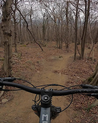
Photos of Piossasco Mountain Bike
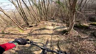
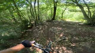
Videos of Piossasco Mountain Bike

trail: Cinghiali
10:24 |
21 |
Mar 8, 2022
trail: Rocca della Madonna
0:16 |
148 |
Mar 8, 2022

trail: Chiantore
0:11 |
196 |
Dec 6, 2021

trail: Cinghiali
9:21 |
151 |
Mar 9, 2017

trail: Lame
26:59 |
370 |
Aug 14, 2013
trail: Rocca della Madonna
5:31 |
39 |
Mar 14, 2026 , Piossasco

trail: Panoramix
4:55 |
46 |
Jul 10, 2025 , Piossasco
trail: Vatan
4:31 |
63 |
Jul 10, 2025 , Piossasco
Recent Trail Reports
| status | trail | date | condition | info | user |
|---|---|---|---|---|---|
| Cinghiali | Jun 14, 2026 @ 8:33am (Europe/Rome) Jun 13, 2026 | Unknown | Medioman92 | ||
| Rubata Bo' | Jun 14, 2026 @ 8:33am (Europe/Rome) Jun 13, 2026 | Dry | Medioman92 | ||
| Prese di Piossasco | May 26, 2026 @ 8:59am (Europe/Monaco) May 25, 2026 | Dry | timm8 | ||
| Rocca della Madonna | May 22, 2026 @ 9:01am (Europe/Monaco) May 22, 2026 | Ideal | glauconicola | ||
| Chiantore | May 22, 2026 @ 9:01am (Europe/Monaco) May 22, 2026 | Ideal | glauconicola | ||
| vipera | May 17, 2026 @ 9:59am (Europe/Rome) May 17, 2026 | Variable | Pistolero79 | ||
| Panoramix | Apr 20, 2026 @ 7:17pm (Europe/Monaco) Apr 20, 2026 | Variable | glauconicola | ||
| Collegamento Prese | Apr 20, 2026 @ 7:17pm (Europe/Monaco) Apr 20, 2026 | Ideal | glauconicola | ||
| Da Bosco delle fate a Colle della Serva uphill | Apr 20, 2026 @ 7:17pm (Europe/Monaco) Apr 20, 2026 | Prevalent Mud | glauconicola | ||
| Direttissima | Apr 12, 2026 @ 2:55pm (Europe/Monaco) Apr 12, 2026 | Ideal | glauconicola |
Activity Feed
| username | action | type | title | date |
|---|---|---|---|---|
| Medioman92 | add | report | activity #96996239 and 1 more | Jun 14, 2026 @ 12:36pm Jun 14, 2026 |
| timm8 | add | report | activity #95552089 and 1 more | May 26, 2026 @ 3:01am May 26, 2026 |
| glauconicola | add | report | activity #95547205 and 2 more | May 26, 2026 @ 12:22am May 26, 2026 |
| Fab82 | vote | trail | activity #95019117 and 1 more | May 18, 2026 @ 8:37pm May 18, 2026 |
| Pistolero79 | add | report | activity #94898059 and 1 more | May 17, 2026 @ 6:56am May 17, 2026 |
Recent Comments
| username | type | title | comment | date |
|---|---|---|---|---|
| trail | Oggi bellissimo, pulito, veloce e ancora poco... | Nov 2, 2025 @ 11:27am Nov 2, 2025 | ||
| trail | Ottimo Grazie! 👍🏻 | Oct 23, 2025 @ 2:18pm Oct 23, 2025 | ||
| trail | ciao, ho modificato io. se servisse... | Oct 23, 2025 @ 12:48pm Oct 23, 2025 | ||
| trail | Per chi ha caricato la traccia del Trail, a... | Oct 23, 2025 @ 4:55am Oct 23, 2025 | ||
| trail | Sempre stupendo anche dopo le piogge. Un po'... | Apr 20, 2025 @ 11:05am Apr 20, 2025 |
Local Badges
-

Epic Mountain Bike Climb 2k47 awarded -

Climbing 10k Badge58 awarded -

Mountain Biking 100k Badge5 awarded -

Epic Ride Descent 2k47 awarded -

Descent 10k Badge58 awarded -

Descent 100k Badge5 awarded
Activity Type Stats
| activitytype | trails | distance | descent | descent distance | total vertical | rating | global rank | state rank | photos | reports | routes | ridelogs |
|---|---|---|---|---|---|---|---|---|---|---|---|---|
| Mountain Bike | 23 | 19 miles | 10,135 ft | 11 miles | 1,834 ft | #3,919 | #239 | 37 | 606 | 8,664 | ||
| E-Bike | 13 | 13 miles | 5,253 ft | 6 miles | 1,637 ft | #4,620 | #445 | 2 | 560 | 1,651 | ||
| Hike | 20 | 16 miles | 8,146 ft | 8 miles | 1,834 ft | #1,724 | #56 | 572 | 231 | |||
| Trail Running | 20 | 16 miles | 8,146 ft | 8 miles | 1,834 ft | #6,625 | #374 | 572 | 254 |
Frequently Asked Questions About Piossasco
▼
What are the highest rated mountain biking trails in Piossasco?
The highest rated mountain biking trails in Piossasco are:
- Cinghiali (4.4/5)
- Chiantore (4.3/5)
- De Vitis (4.3/5)
- Vatan (4.2/5)
- Rocca della Madonna (4.2/5)
▼
What is the best time of the year to ride in Piossasco?
Based on ride log data, the most popular months to ride in Piossasco are:
- May (36 activities)
- April (35 activities)
- March (32 activities)
▼
Where can I park to ride in Piossasco?
Check the Piossasco trail map for trailhead and parking information. Community members regularly update access and parking details for trails in the area.
▼
What is the longest trail in Piossasco?
The longest trail in Piossasco is Chiantore at 1.7 miles. View all trails sorted by distance.
Activities
Trails
Points of Interest
- By zorobyzo
 & contributors
 - Admins: silviu86, adessoomaipiu
- #23650 - 5,162 views
- piossasco activity log | embed map of Piossasco mountain bike trails |
Downloading of trail gps tracks in kml & gpx formats is enabled for Piossasco.
You must login to download files.