close
-
Layers w
- Weather Layers
- Pro
- Pro
- Pro
- Pro
- Pro
- Pro
- More Layers
- Pro
- Pro
- Pro
- Pro
-
Upgrade to

3D
Trail Conditions
- Unknown
- Snow Groomed
- Snow Packed
- Snow Covered
- Snow Cover Partial
- Freeze/thaw Cycle
- Icy
- Prevalent Mud
- Wet
- Variable
- Ideal
- Dry
- Very Dry
Trail Flow (Ridden Direction)
Trailforks scans users ridelogs to determine the most popular direction each trail is ridden. A good flowing trail network will have most trails flowing in a single direction according to their intension.
The colour categories are based on what percentage of riders are riding a trail in its intended direction.
The colour categories are based on what percentage of riders are riding a trail in its intended direction.
- > 96%
- > 90%
- > 80%
- > 70%
- > 50%
- < 50%
- bi-directional trail
- no data
Trail Last Ridden
Trailforks scans ridelogs to determine the last time a trail was ridden.
- < 2 days
- < 1 week
- < 2 weeks
- < 1 month
- < 6 months
- > 6 months
Trail Ridden Direction
The intended direction a trail should be ridden.
- Downhill Only
- Downhill Primary
- Both Directions
- Uphill Primary
- Uphill Only
- One Direction
Contribute Details
Colors indicate trail is missing specified detail.
- Description
- Photos
- Description & Photos
- Videos
Trail Popularity ?
Trailforks scans ridelogs to determine which trails are ridden the most in the last 9 months.
Trails are compared with nearby trails in the same city region with a possible 25 colour shades.
Think of this as a heatmap, more rides = more kinetic energy = warmer colors.
- most popular
- popular
- less popular
- not popular
ATV/ORV/OHV Filter
Max Vehicle Width
inches
US Cell Coverage
Legend

Radar Time
Activity Recordings
Trailforks uses anonymized public activity data.
?
Activity Recordings
Trailforks uses anonymized public activity data.
?
Personal Heatmap
▶
Activity Types
all
/
none
▶
Options
2
Date range
month
–
Winter Trails
Warning
A routing network for winter maps does not exist. Selecting trails using the winter trails layer has been disabled.
Missing Trails
Most Popular
Least Popular
Trails are colored based on popularity. The more popular a trail is, the more red. Less popular trails trend towards green.
Jump Magnitude Heatmap
Heatmap of where riders jump on trails. Zoom in to see individual jumps, click circles to view jump details.
BC Backroad Status
![map legend]()
Service Road Atlas is a free to use, community-driven service for viewing and creating reports on the numerous back-country service roads around B.C. and Alberta.

Slope Aspect
Direction the slope faces
Trails Deemphasized
Trails are shown in grey.
Only show trails with no bike usage.
Suggested Layers
Based on selected activity type
Save the current map location and zoom level as your default home location whenever this page is loaded.
Save
No description for Pitman has been added yet!
Login or register to submit one.
Activities Click to view
- Mountain Bike
51 trails
- Gravel Bike
0 trails
- Hike
38 trails
- Trail Running
38 trails
Region Details
- 1
- 38
- 12
Region Status
Open as of Aug 2, 2025Local Trail Association
Stats
- Avg Trail Rating
- Trails (view details)
- 51
- Trails Mountain Bike
- 51
- Trails E-Bike
- 1
- Trails Horse
- 2
- Trails Hike
- 38
- Trails Trail Running
- 38
- Trails Dirtbike/Moto
- 1
- Trails Observed Trials
- 1
- Trails ATV/ORV/OHV
- 1
- Trails Snowmobile
- 1
- Trails Snowshoe
- 1
- Trails Downhill Ski
- 1
- Trails Backcountry Ski
- 1
- Trails Nordic Ski
- 1
- Total Distance
- 22 miles
- Total Descent Distance
- 7 miles
- Total Descent
- 986 ft
- Total Vertical
- 92 ft
- Highest Trailhead
- 140 ft
- Reports
- 54
- Photos
- 48
- Ridden Counter
- 4,971
Sub Regions
-
Ceres Park
- 38
- 12
-
Elephant Swamp Trail
- 1
Popular Pitman Mountain Biking Trails
• 100 ★ 0.0 • 666 ft • 3 ft • 228 •
Popular green difficulty singletrack. This mountain bike primary trail can be used both directions. On average it takes minutes to complete this trail.
• 100 ★ 0.0 • 505 ft • 0 ft • 200 •
Popular green difficulty singletrack. This mountain bike primary trail can be used both directions. On average it takes minutes to complete this trail.
• 95 ★ 0.0 • 1 mile • 89 ft • 190 •
Popular blue difficulty singletrack. This mountain bike primary trail can be used both directions. On average it takes 12 minutes to complete this trail.
• 75 ★ 0.0 • 971 ft • 51 ft • 169 •
Popular black diamond difficulty singletrack. This mountain bike primary trail can be used both directions. It features drop and gap jump. On average it takes 4 minutes to complete this trail.
• 100 ★ 0.0 • 902 ft • 25 ft • 158 •
Popular green difficulty singletrack. This mountain bike primary trail can be used both directions. On average it takes 2 minutes to complete this trail.
• 95 ★ 0.0 • 951 ft • 16 ft • 144 •
Popular green difficulty singletrack. This mountain bike primary trail can be used both directions. On average it takes 2 minutes to complete this trail.
• 95 ★ 0.0 • 653 ft • 16 ft • 130 •
Popular green difficulty singletrack. This mountain bike primary trail can be used both directions. On average it takes 1 minutes to complete this trail.
Pitman Mountain Bike Routes
4 miles • 122 ft • 4 • Loop •
Start at the small lot Easy ride following stream and lake Under RT55 (Break Point) Head for the...
4 miles • 284 ft • 11 •
ceres route lil loop - seeing most of what the park has to offer
1 mile • 76 ft • 0 • Loop •
Start at small lot Along stream xover to hit Intermediate trail loop half way point under Rt55 Head back...
• 3 miles • 167 ft • 11 •
• 7 miles • 608 ft • 24 •
• 5 miles • 418 ft • 9 •
Photos of Pitman Mountain Bike
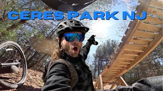
Videos of Pitman Mountain Bike
trail: Figure 8 Trail
0:15 |
113 |
Nov 9, 2024
8:27 |
40 |
Nov 4, 2025
youtuber
![B-Line (aka Wilson Trail) Jump Line – Ceres...]()

trail: Wilson Trail
2:13 |
464 |
Jul 26, 2023 , Pitman
Recent Trail Reports
| status | trail | date | condition | info | user |
|---|---|---|---|---|---|
| Elephant Swamp Full Trail | Aug 2, 2025 @ 7:52am Aug 2, 2025 | Ideal | clem18 | ||
| Along the Way | Jun 26, 2025 @ 3:04pm Jun 26, 2025 | Unknown | iuEW6SRW | ||
| Shortie Trail | Jan 14, 2024 @ 8:16am Jan 14, 2024 | Variable | skiphreaknj | ||
| Shortcut | Jan 14, 2024 @ 8:16am Jan 14, 2024 | Variable | skiphreaknj | ||
| Tyler Lake Trail | Jan 14, 2024 @ 8:16am Jan 14, 2024 | Variable | skiphreaknj | ||
| Putt Trail | Jan 14, 2024 @ 8:16am Jan 14, 2024 | Variable | skiphreaknj | ||
| Split Trail | Jan 14, 2024 @ 8:16am Jan 14, 2024 | Variable | skiphreaknj | ||
| Creek Trail | Jan 14, 2024 @ 8:16am Jan 14, 2024 | Prevalent Mud | skiphreaknj | ||
| Snake Trail | Jan 14, 2024 @ 8:16am Jan 14, 2024 | Variable | skiphreaknj | ||
| S Turn | Jan 14, 2024 @ 8:16am Jan 14, 2024 | Variable | skiphreaknj |
Activity Feed
| username | action | type | title | date |
|---|---|---|---|---|
| aggressorblue | wishlist | route | activity #96015899 | Jun 1, 2026 @ 7:26am Jun 1, 2026 |
| Philliesnine77 | wishlist | region | activity #96010703 | Jun 1, 2026 @ 5:27am Jun 1, 2026 |
| aggressorblue | wishlist | trail | activity #95643648 | May 27, 2026 @ 10:19am May 27, 2026 |
| aggressorblue | wishlist | trail | activity #95642880 | May 27, 2026 @ 10:08am May 27, 2026 |
| brettpalumbo | update | trail | activity #95631908 and 2 more | May 27, 2026 @ 7:08am May 27, 2026 |
Recent Comments
| username | type | title | comment | date |
|---|---|---|---|---|
| trail | Rocky | Dec 7, 2025 @ 10:23am Dec 7, 2025 | ||
| trail | Black diamond | Jan 14, 2024 @ 1:55pm Jan 14, 2024 | ||
| trail | Should it be Black Diamond, Blue? | Jan 14, 2024 @ 1:47pm Jan 14, 2024 | ||
| trail | Drop and gap jump on this trail | Jan 14, 2024 @ 12:32pm Jan 14, 2024 |
Local Badges
-

Completionist0 awarded -

10 Green Trails72 awarded -

Epic Mountain Bike Climb 2k0 awarded -

Climbing 10k Badge7 awarded -

Mountain Biking 100k Badge0 awarded -

Epic Ride Descent 2k0 awarded
Bike & Skill Parks
| name | type | city | rating |
|---|---|---|---|
| Pitman Pumptrack | skill park | Pitman |
Local Mountain Biking Directory
-
JonnyGMTB coaching
-
RidetopiaBike Shop
-
Beachwood BicyclesBike Shop
-
Action WheelsBike Shop
-
Wyckoff Cycle LlcBike Shop
-
Caffeinated CyclistBike Shop
Activity Type Stats
| activitytype | trails | distance | descent | descent distance | total vertical | rating | global rank | state rank | photos | reports | routes | ridelogs |
|---|---|---|---|---|---|---|---|---|---|---|---|---|
| Mountain Bike | 51 | 22 miles | 984 ft | 7 miles | 92 ft | #2,357 | #842 | 49 | 54 | 3 | 7,554 | |
| E-Bike | 1 | 230 ft | 3 ft | 15 | 1 | 144 | ||||||
| Horse | 2 | 5 miles | 49 ft | 2 miles | 36 ft | 1 | 1 | |||||
| Hike | 38 | 18 miles | 827 ft | 6 miles | 92 ft | #7,428 | #2,634 | 27 | 1 | 69 | ||
| Trail Running | 38 | 18 miles | 827 ft | 6 miles | 92 ft | #6,914 | #2,272 | 27 | 1 | 35 | ||
| Dirtbike/Moto | 1 | 230 ft | 3 ft | 1 | ||||||||
| Observed Trials | 1 | 230 ft | 3 ft | |||||||||
| ATV/ORV/OHV | 1 | 230 ft | 3 ft | 1 | ||||||||
| Snowmobile | 1 | 230 ft | 3 ft | 20 | 1 | |||||||
| Snowshoe | 1 | 230 ft | 3 ft | 1 | ||||||||
| Downhill Ski | 1 | 230 ft | 3 ft | |||||||||
| Backcountry Ski | 1 | 230 ft | 3 ft | |||||||||
| Nordic Ski | 1 | 230 ft | 3 ft |
Frequently Asked Questions About Pitman
▼
What are the best places to ride in Pitman?
Pitman has 2 areas to explore for mountain biking. The top rated areas are:
▼
What are the highest rated mountain biking trails in Pitman?
The highest rated mountain biking trails in Pitman are:
- White Oak Trail (0/5)
- Top Hat Trail (0/5)
- Crimson Tide (0/5)
- Tyler Lake Trail (0/5)
- RIght Angle Trail (0/5)
▼
What is the best time of the year to ride in Pitman?
Based on ride log data, the most popular months to ride in Pitman are:
- August (41 activities)
- September (35 activities)
- November (33 activities)
▼
Where can I park to ride in Pitman?
There are 4 parking locations listed in Pitman. The most popular parking spots are: View all parking and trailhead locations on the map to plan your visit.
Trails
Points of Interest
- By gerrycreighton
 WMBC staff & contributors
 - Admins: JORBA, JARJORBA
- #6553 - 2,959 views
- pitman activity log | embed map of Pitman mountain bike trails | pitman mountain biking points of interest
Downloading of trail gps tracks in kml & gpx formats is enabled for Pitman.
You must login to download files.