close
-
Layers w
- Weather Layers
- Pro
- Pro
- Pro
- Pro
- Pro
- Pro
- More Layers
- Pro
- Pro
- Pro
- Pro
-
Upgrade to

3D
Trail Conditions
- Unknown
- Snow Groomed
- Snow Packed
- Snow Covered
- Snow Cover Partial
- Freeze/thaw Cycle
- Icy
- Prevalent Mud
- Wet
- Variable
- Ideal
- Dry
- Very Dry
Trail Flow (Ridden Direction)
Trailforks scans users ridelogs to determine the most popular direction each trail is ridden. A good flowing trail network will have most trails flowing in a single direction according to their intension.
The colour categories are based on what percentage of riders are riding a trail in its intended direction.
The colour categories are based on what percentage of riders are riding a trail in its intended direction.
- > 96%
- > 90%
- > 80%
- > 70%
- > 50%
- < 50%
- bi-directional trail
- no data
Trail Last Ridden
Trailforks scans ridelogs to determine the last time a trail was ridden.
- < 2 days
- < 1 week
- < 2 weeks
- < 1 month
- < 6 months
- > 6 months
Trail Ridden Direction
The intended direction a trail should be ridden.
- Downhill Only
- Downhill Primary
- Both Directions
- Uphill Primary
- Uphill Only
- One Direction
Contribute Details
Colors indicate trail is missing specified detail.
- Description
- Photos
- Description & Photos
- Videos
Trail Popularity ?
Trailforks scans ridelogs to determine which trails are ridden the most in the last 9 months.
Trails are compared with nearby trails in the same city region with a possible 25 colour shades.
Think of this as a heatmap, more rides = more kinetic energy = warmer colors.
- most popular
- popular
- less popular
- not popular
ATV/ORV/OHV Filter
Max Vehicle Width
inches
US Cell Coverage
Legend

Radar Time
Activity Recordings
Trailforks uses anonymized public activity data.
?
Activity Recordings
Trailforks uses anonymized public activity data.
?
Personal Heatmap
▶
Activity Types
all
/
none
▶
Options
2
Date range
month
–
Winter Trails
Warning
A routing network for winter maps does not exist. Selecting trails using the winter trails layer has been disabled.
Missing Trails
Most Popular
Least Popular
Trails are colored based on popularity. The more popular a trail is, the more red. Less popular trails trend towards green.
Jump Magnitude Heatmap
Heatmap of where riders jump on trails. Zoom in to see individual jumps, click circles to view jump details.
BC Backroad Status
![map legend]()
Service Road Atlas is a free to use, community-driven service for viewing and creating reports on the numerous back-country service roads around B.C. and Alberta.

Slope Aspect
Direction the slope faces
Trails Deemphasized
Trails are shown in grey.
Only show trails with no bike usage.
Suggested Layers
Based on selected activity type
Save the current map location and zoom level as your default home location whenever this page is loaded.
Save
No description for Pleasant Valley has been added yet!
Login or register to submit one.
Activities Click to view
- Mountain Bike
64 trails
- E-Bike
30 trails
- Gravel Bike
4 trails
- Adaptive Bike
4 trails
- Winter Fat Bike
3 trails
- Hike
65 trails
- Trail Running
65 trails
Region Details
- 7
- 19
- 20
- 7
Region Status
Open as of 1 dayStats
- Avg Trail Rating
- Trails (view details)
- 53
- Trails Mountain Bike
- 65
- Trails E-Bike
- 30
- Trails Gravel Bike
- 4
- Trails Adaptive Bike
- 4
- Trails Winter Fat Bike
- 3
- Trails Hike
- 65
- Trails Trail Running
- 65
- Trails Snowshoe
- 1
- Total Distance
- 35 miles
- Total Descent
- 7,010 ft
- Total Vertical
- 498 ft
- Highest Trailhead
- 822 ft
- Reports
- 843
- Photos
- 101
- Ridden Counter
- 9,570
Sub Regions
-
Red Wing Recreation Area
-
Taconic Hereford Multiple Use Area (909)
- 17
- 18
- 7
Popular Pleasant Valley Mountain Biking Trails
• 100 ★ 4.3 • 3,750 ft • 55 ft • 530 •
Highly rated popular blue difficulty singletrack. This mountain bike primary trail and has a moderate overall physical rating with a 55 ft blue climb. On average it takes 6 minutes to complete this trail.
• 90 ★ 3.3 • 1,952 ft • 32 ft • 445 •
Popular green difficulty singletrack. This mountain bike primary trail can be used both directions with a 32 ft green climb. On average it takes 3 minutes to complete this trail.
• 100 ★ 4.0 • 591 ft • 17 ft • 410 •
Popular green difficulty singletrack. This mountain bike primary trail can be used both directions. On average it takes minutes to complete this trail.
• 85 ★ 4.4 • 2 miles • 210 ft • 409 •
One of 909's most popular trails, with nice tecky flow. Can be ridden either way, its either more climb or more downhill depending on which way you go.
• 95 ★ 3.0 • 551 ft • 52 ft • 400 •
Popular green difficulty singletrack. This mountain bike primary trail can be used both directions. On average it takes minutes to complete this trail.
• 95 ★ 4.2 • 2,680 ft • 23 ft • 366 •
Highly rated popular blue difficulty singletrack. This mountain bike primary trail can be used both directions and has a moderate overall physical rating with a 23 ft blue climb. On average it takes 6 minutes to complete this trail.
• 80 ★ 4.5 • 535 ft • 0 ft • 355 •
Popular blue difficulty singletrack. This mountain bike primary trail can be used downhill primary and has a hard overall physical rating with a 0 ft double black diamond climb. Adaptive MTB rating: amtb black. Trail visibility is sometimes hard to follow. On average it takes minutes to complete this trail.
Pleasant Valley Mountain Bike Routes
6 miles • 606 ft • 15 • Loop •
An easy loop of mostly Green and Blues, with a nice downhill on Byk Head.
5 miles • 815 ft • 8 • Loop •
Nice loop for trail running. A couple of hills at the start, but after these, it is pretty gentle.
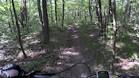
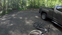
Photos of Pleasant Valley Mountain Bike
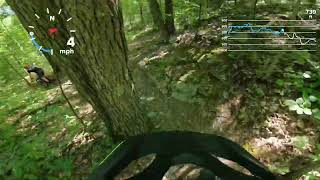
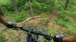
Videos of Pleasant Valley Mountain Bike

trail: Green Acres
0:54 |
341 |
Jul 15, 2019
trail: Byk Hed
4:45 |
307 |
Jul 7, 2017
trail: Mercury
4:57 |
250 |
Jul 5, 2017

trail: Tunnel
2:22 |
462 |
May 20, 2013
trail: Byk Hed
8:52 |
324 |
Jul 6, 2022 , Pleasant Valley
trail: Mercury
4:36 |
1105 |
Jul 26, 2020 , Pleasant Valley

trail: Green Acres
0:22 |
699 |
May 25, 2020 , Pleasant Valley

trail: Byk Hed
6:39 |
571 |
May 24, 2020 , Pleasant Valley
Recent Trail Reports
| status | trail | date | condition | info | user |
|---|---|---|---|---|---|
| Timbuktwo | Jun 21, 2026 @ 1:25pm (America/New_York) 1 day | Unknown | racrdave FITC 909 | ||
| HorseShoe | Jun 12, 2026 @ 12:17pm (America/New_York) Jun 12, 2026 | Variable | michaelrkane01 FCBC | ||
| Mary Murphy | Jun 12, 2026 @ 12:17pm (America/New_York) Jun 12, 2026 | Ideal | michaelrkane01 FCBC | ||
| Ant Hill | Jun 12, 2026 @ 12:17pm (America/New_York) Jun 12, 2026 | Ideal | michaelrkane01 FCBC | ||
| Fongs Way Clockwise | May 31, 2026 @ 1:51pm (America/New_York) May 31, 2026 | Ideal | racrdave FITC 909 | ||
| TimBuk2 | May 29, 2026 @ 3:41pm (America/New_York) May 29, 2026 | Ideal | racrdave FITC 909 | ||
| Jeep trail | May 26, 2026 @ 11:55pm (America/New_York) May 26, 2026 | Ideal | michaelrkane01 FCBC | ||
| Snowmobile | May 19, 2026 @ 7:52pm (America/New_York) May 19, 2026 | Unknown | michaelrkane01 FCBC | ||
| Byk Hed | May 16, 2026 @ 1:28pm (America/New_York) May 16, 2026 | Ideal | michaelrkane01 FCBC | ||
| Bky Hed extra loop | May 16, 2026 @ 10:59am (America/New_York) May 16, 2026 | Ideal | michaelrkane01 FCBC |
Activity Feed
| username | action | type | title | date |
|---|---|---|---|---|
| racrdave | add | report | activity #97498753 and 1 more | Jun 21, 2026 @ 10:25am 1 day |
| anchotequila | wishlist | route | activity #97422696 | Jun 20, 2026 @ 12:26pm 2 days |
| AaronkgOFnh | wishlist | trail | activity #97275568 | Jun 18, 2026 @ 2:14pm Jun 18, 2026 |
| AaronkgOFnh | wishlist | region | activity #97275224 | Jun 18, 2026 @ 2:07pm Jun 18, 2026 |
| TedYpTwrB | wishlist | route | activity #97195946 | Jun 17, 2026 @ 10:52am Jun 17, 2026 |
Recent Comments
| username | type | title | comment | date |
|---|---|---|---|---|
| report | Assignment | Feb 19, 2026 @ 9:58am Feb 19, 2026 | ||
| report | Assignment | Feb 19, 2026 @ 9:56am Feb 19, 2026 | ||
| trail | Fun trail. Rides well in either direction. | Feb 11, 2026 @ 7:24am Feb 11, 2026 | ||
| trail | It's still getting better after 20 years. Glad... | Nov 13, 2025 @ 5:04am Nov 13, 2025 | ||
| trail | Techy, tight, fun. Mostly downhill. | Nov 12, 2025 @ 11:05am Nov 12, 2025 |
Local Badges
-

10 Green Trails148 awarded -

10 Blue Trails174 awarded -

Epic Ride Climb 2k0 awarded -

Climbing 10k Badge48 awarded -

Climbing 100k Badge0 awarded -

Epic Ride Descent 2k0 awarded
Activity Type Stats
| activitytype | trails | distance | descent | descent distance | total vertical | rating | global rank | state rank | photos | reports | routes | ridelogs |
|---|---|---|---|---|---|---|---|---|---|---|---|---|
| Mountain Bike | 64 | 35 miles | 7,011 ft | 17 miles | 499 ft | #1,802 | #661 | 102 | 843 | 4 | 8,372 | |
| E-Bike | 30 | #7,914 | #2,389 | 701 | 165 | |||||||
| Gravel Bike | 4 | #741 | #1,237 | 14 | 19 | |||||||
| Adaptive Bike | 4 | #692 | #1,958 | 6 | ||||||||
| Winter Fat Bike | 3 | #415 | #1,185 | 23 | 1 | |||||||
| Hike | 65 | 35 miles | 7,011 ft | 17 miles | 499 ft | #5,575 | #1,961 | 843 | 1 | 230 | ||
| Trail Running | 65 | 35 miles | 7,011 ft | 17 miles | 499 ft | #5,061 | #1,583 | 843 | 1 | 37 | ||
| Snowshoe | 1 | 5 | 7 |
Frequently Asked Questions About Pleasant Valley
▼
What are the best places to ride in Pleasant Valley?
Pleasant Valley has 2 areas to explore for mountain biking. The top rated areas are:
▼
What are the highest rated mountain biking trails in Pleasant Valley?
The highest rated mountain biking trails in Pleasant Valley are:
- Fongs Way Clockwise (4.3/5)
- Byk Hed (4.3/5)
- Green Acres (4.2/5)
- TimBuk2 (4.2/5)
- Mercury (4.1/5)
▼
What is the best time of the year to ride in Pleasant Valley?
Based on ride log data, the most popular months to ride in Pleasant Valley are:
- July (198 activities)
- June (192 activities)
- September (180 activities)
▼
Where can I park to ride in Pleasant Valley?
There are 4 parking locations listed in Pleasant Valley. The most popular parking spots are: View all parking and trailhead locations on the map to plan your visit.
Activities
Trails
Points of Interest
- By Hvmtb & contributors
- Admins: apply
- #12374 - 3,615 views
- pleasant valley activity log | embed map of Pleasant Valley mountain bike trails | pleasant valley mountain biking points of interest polygons
Downloading of trail gps tracks in kml & gpx formats is enabled for Pleasant Valley.
You must login to download files.