close
-
Layers w
- Weather Layers
- Pro
- Pro
- Pro
- Pro
- Pro
- Pro
- More Layers
- Pro
- Pro
- Pro
- Pro
-
Upgrade to

3D
Trail Conditions
- Unknown
- Snow Groomed
- Snow Packed
- Snow Covered
- Snow Cover Partial
- Freeze/thaw Cycle
- Icy
- Prevalent Mud
- Wet
- Variable
- Ideal
- Dry
- Very Dry
Trail Flow (Ridden Direction)
Trailforks scans users ridelogs to determine the most popular direction each trail is ridden. A good flowing trail network will have most trails flowing in a single direction according to their intension.
The colour categories are based on what percentage of riders are riding a trail in its intended direction.
The colour categories are based on what percentage of riders are riding a trail in its intended direction.
- > 96%
- > 90%
- > 80%
- > 70%
- > 50%
- < 50%
- bi-directional trail
- no data
Trail Last Ridden
Trailforks scans ridelogs to determine the last time a trail was ridden.
- < 2 days
- < 1 week
- < 2 weeks
- < 1 month
- < 6 months
- > 6 months
Trail Ridden Direction
The intended direction a trail should be ridden.
- Downhill Only
- Downhill Primary
- Both Directions
- Uphill Primary
- Uphill Only
- One Direction
Contribute Details
Colors indicate trail is missing specified detail.
- Description
- Photos
- Description & Photos
- Videos
Trail Popularity ?
Trailforks scans ridelogs to determine which trails are ridden the most in the last 9 months.
Trails are compared with nearby trails in the same city region with a possible 25 colour shades.
Think of this as a heatmap, more rides = more kinetic energy = warmer colors.
- most popular
- popular
- less popular
- not popular
ATV/ORV/OHV Filter
Max Vehicle Width
inches
US Cell Coverage
Legend

Radar Time
Activity Recordings
Trailforks uses anonymized public activity data.
?
Activity Recordings
Trailforks uses anonymized public activity data.
?
Personal Heatmap
▶
Activity Types
all
/
none
▶
Options
2
Date range
month
–
Winter Trails
Warning
A routing network for winter maps does not exist. Selecting trails using the winter trails layer has been disabled.
Missing Trails
Most Popular
Least Popular
Trails are colored based on popularity. The more popular a trail is, the more red. Less popular trails trend towards green.
Jump Magnitude Heatmap
Heatmap of where riders jump on trails. Zoom in to see individual jumps, click circles to view jump details.
BC Backroad Status
![map legend]()
Service Road Atlas is a free to use, community-driven service for viewing and creating reports on the numerous back-country service roads around B.C. and Alberta.

Slope Aspect
Direction the slope faces
Trails Deemphasized
Trails are shown in grey.
Only show trails with no bike usage.
Suggested Layers
Based on selected activity type
Save the current map location and zoom level as your default home location whenever this page is loaded.
Save
No description for Pleasanton has been added yet!
Login or register to submit one.
Activities Click to view
- Mountain Bike
121 trails
- E-Bike
42 trails
- Adaptive Bike
0 trails
- Winter Fat Bike
0 trails
- Horse
5 trails
- Hike
132 trails
- Trail Running
132 trails
Region Details
- 19
- 7
- 41
- 46
- 2
Region Status
Open as of Jun 19, 2026Stats
- Avg Trail Rating
- Trails (view details)
- 126
- Trails Mountain Bike
- 121
- Trails E-Bike
- 42
- Trails Horse
- 5
- Trails Hike
- 132
- Trails Trail Running
- 132
- Total Distance
- 161 miles
- Total Descent
- 17,759 ft
- Total Vertical
- 2,836 ft
- Highest Trailhead
- 2,851 ft
- Reports
- 506
- Photos
- 94
- Ridden Counter
- 20,764
Sub Regions
-
Pleasanton Ridge
- 27
- 27
-
Shadow Cliffs
- 7
- 4
- 1
-
Sunol Regional Wilderness
- 6
- 16
- 2
Popular Pleasanton Mountain Biking Trails
• 100 ★ 3.0 • 2,499 ft • 19 ft • 404 •
Popular green difficulty singletrack. This mountain bike primary trail can be used both directions. On average it takes 1 minutes to complete this trail.
• 90 ★ 4.0 • 2,192 ft • 37 ft • 355 •
Popular blue difficulty singletrack. This mountain bike primary trail can be used both directions. On average it takes 4 minutes to complete this trail.
• 100 ★ 4.0 • 594 ft • 0 ft • 315 •
Popular green difficulty singletrack. This multi-use trail can be used both directions and has a easy overall physical rating with a 0 ft green climb. Trail visibility is always easy to follow. On average it takes minutes to complete this trail.
• 90 ★ 4.0 • 797 ft • 29 ft • 303 •
Popular green difficulty singletrack. This multi-use trail can be used both directions and has a moderate overall physical rating with a 29 ft blue climb. Trail visibility is always easy to follow. On average it takes 5 minutes to complete this trail.
• 90 ★ 4.0 • 991 ft • 0 ft • 300 •
A beautiful ride through the . Trail can be bumpy.
• 95 ★ 4.0 • 299 ft • 32 ft • 292 •
Popular green difficulty singletrack. This multi-use trail can be used both directions and has a easy overall physical rating with a 32 ft green climb. Trail visibility is always easy to follow. On average it takes minutes to complete this trail.
• 85 ★ 3.0 • 2,920 ft • 38 ft • 283 •
Popular green difficulty singletrack. This mountain bike primary trail can be used both directions. On average it takes 2 minutes to complete this trail.
• 95 ★ 4.7 • 2,193 ft • 59 ft • 250 •
Popular blue difficulty singletrack. This mountain bike primary trail can be used both directions and has a hard overall physical rating with a 59 ft black diamond climb. On average it takes 2 minutes to complete this trail.
Pleasanton Mountain Bike Routes
★ 4.0 • 10 miles • 1,495 ft • 3 • Loop •
Enter Golden Eagle HOA Entrance. Augustin Bernal Park. 8063 Golden Eagle Way, Pleasanton, CA 94588...
13 miles • 2,343 ft • 8 • Loop •
start at Castle Ridge, climb up to ridge, do to to , Down to , up to traverse, back up double track to ....
★ 1.0 • 8 miles • 1,373 ft • 3 • Loop •
Enter Golden Eagle HOA Entrance. Augustin Bernal Park. 8063 Golden Eagle Way, Pleasanton, CA 94588...
★ 3.4 • 8 miles • 1,425 ft • 4 • Loop •
Start at the Foothill entrance. Great training ride for climbing.
7 miles • 1,425 ft • 4 • Loop •
Hard climb - Fun Descent. Best time ride, weekday mornings, few hikers on the trail.
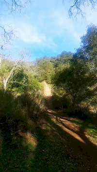
Photos of Pleasanton Mountain Bike
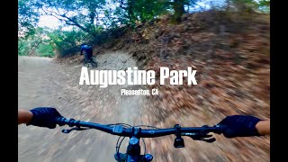
Videos of Pleasanton Mountain Bike
trail: Sinbad Creek
0:13 |
537 |
Feb 29, 2020

trail: Iron Horse
2:29 |
225 |
Feb 20, 2011

trail: Iron Horse
5:10 |
180 |
Feb 20, 2011

trail: Ridgeline
8:21 |
518 |
Nov 5, 2020 , Pleasanton

trail: Valley View Trail
8:21 |
376 |
Nov 5, 2020 , Pleasanton
trail: Bay Leaf (Double Track)
8:21 |
317 |
Nov 5, 2020 , Pleasanton
youtuber
![Valle Vista: The All-New Flow Trail at...]()

trail: Valle Vista Trail
4:24 |
119 |
Dec 27, 2025 , Pleasanton
Recent Trail Reports
| status | trail | date | condition | info | user |
|---|---|---|---|---|---|
| Shady Creek | Jun 19, 2026 @ 10:09am (America/Los_Angeles) Jun 19, 2026 | Very Dry | carenaw92 | ||
| Mariposa Trail | Jun 19, 2026 @ 10:09am (America/Los_Angeles) Jun 19, 2026 | Very Dry | carenaw92 | ||
| Valle Vista Trail | Jun 19, 2026 @ 10:09am (America/Los_Angeles) Jun 19, 2026 | Very Dry | carenaw92 | ||
| Turtle Pond Trail | Jun 19, 2026 @ 10:09am (America/Los_Angeles) Jun 19, 2026 | Very Dry | carenaw92 | ||
| Schuhart Fork | Jun 19, 2026 @ 10:09am (America/Los_Angeles) Jun 19, 2026 | Very Dry | carenaw92 | ||
| Courdet | Jun 19, 2026 @ 10:09am (America/Los_Angeles) Jun 19, 2026 | Very Dry | carenaw92 | ||
| Ridgeline Alternate Line | Apr 26, 2026 @ 4:32pm (America/Los_Angeles) Apr 26, 2026 | Ideal | hjroyer | ||
| Schuhart | Apr 26, 2026 @ 4:32pm (America/Los_Angeles) Apr 26, 2026 | Ideal | hjroyer | ||
| Valley View Trail | Apr 26, 2026 @ 4:32pm (America/Los_Angeles) Apr 26, 2026 | Ideal | hjroyer | ||
| Flag Hill Trail | Mar 13, 2026 @ 1:07pm (America/Los_Angeles) Mar 13, 2026 | Dry | andi-frede |
Activity Feed
| username | action | type | title | date |
|---|---|---|---|---|
| ArjangcaTHa7 | vote | trail | activity #98068325 and 6 more | Jun 29, 2026 @ 9:13am 8 hours |
| mooshik | wishlist | trail | activity #98039493 | Jun 28, 2026 @ 6:43pm 22 hours |
| carenaw92 | add | report | activity #97352837 and 5 more | Jun 19, 2026 @ 4:35pm Jun 19, 2026 |
| carenaw92 | wishlist | route | activity #97283466 | Jun 18, 2026 @ 4:49pm Jun 18, 2026 |
| lisaonride | wishlist | route | activity #96967976 | Jun 14, 2026 @ 7:46am Jun 14, 2026 |
Recent Comments
| username | type | title | comment | date |
|---|---|---|---|---|
| trail | This is a very (very) popular hiking, walking... | Jan 1, 2026 @ 7:39am Jan 1, 2026 | ||
| trail | Closed from top | Aug 10, 2025 @ 9:46am Aug 10, 2025 | ||
| trail | Awesome trail. | May 10, 2025 @ 10:34am May 10, 2025 | ||
| trail | Hit this on my hardtail and regretted it. Very... | Apr 21, 2025 @ 8:04pm Apr 21, 2025 | ||
| trail | Insane trail. Definitely recommend. Really fun... | Apr 2, 2025 @ 10:59am Apr 2, 2025 |
Local Badges
-

Epic Ride Climb 2k115 awarded -

Climbing 10k Badge150 awarded -

Climbing 100k Badge22 awarded -

Epic Ride Descent 2k116 awarded -

Descent 10k Badge151 awarded -

Descent 100k Badge22 awarded
Bike & Skill Parks
| name | type | city | rating |
|---|---|---|---|
| Pleasanton BMX Park | skill park | Pleasanton |
Local Mountain Biking Directory
-
Beeline Bikes Tri-Valley
![Beeline Bikes Tri-Valley]()
-
Bicycles! PleasantonBike Shop
-
Cyclepath PleasantonBike Shop
-
Real BicyclesBike Shop
Activity Type Stats
| activitytype | trails | distance | descent | descent distance | total vertical | rating | global rank | state rank | photos | reports | routes | ridelogs |
|---|---|---|---|---|---|---|---|---|---|---|---|---|
| Mountain Bike | 121 | 146 miles | 16,565 ft | 56 miles | 2,349 ft | #877 | #346 | 91 | 510 | 7 | 29,854 | |
| E-Bike | 42 | 35 miles | 3,658 ft | 12 miles | 1,932 ft | #2,224 | #958 | 1 | 452 | 5,977 | ||
| Horse | 5 | 6 miles | 463 ft | 2 miles | 1,965 ft | #2,436 | #1,349 | 35 | ||||
| Hike | 132 | 159 miles | 17,707 ft | 59 miles | 2,835 ft | #1,297 | #594 | 1 | 495 | 1,282 | ||
| Trail Running | 132 | 159 miles | 17,707 ft | 59 miles | 2,835 ft | #989 | #369 | 495 | 981 |
Frequently Asked Questions About Pleasanton
▼
What are the best places to ride in Pleasanton?
Pleasanton has 3 areas to explore for mountain biking. The top rated areas are:
▼
What are the highest rated mountain biking trails in Pleasanton?
The highest rated mountain biking trails in Pleasanton are:
- Valle Vista Trail (4.3/5)
- Equestrian (4.2/5)
- Vogel Lane (4.1/5)
- Furious Muffin (4.1/5)
- Indian Joe Trail (4.1/5)
▼
What is the best time of the year to ride in Pleasanton?
Based on ride log data, the most popular months to ride in Pleasanton are:
- May (142 activities)
- November (140 activities)
- April (139 activities)
▼
Where can I park to ride in Pleasanton?
There are 5 parking locations listed in Pleasanton. The most popular parking spots are: View all parking and trailhead locations on the map to plan your visit.
Activities
Trails
Points of Interest
- By brenthillier
 NSMBA TRAILFORKS & contributors
 - Admins: BTCEB
- #8262 - 5,322 views
- pleasanton activity log | embed map of Pleasanton mountain bike trails | pleasanton mountain biking points of interest polygons
Downloading of trail gps tracks in kml & gpx formats is enabled for Pleasanton.
You must login to download files.