close
-
Layers w
- Weather Layers
- Pro
- Pro
- Pro
- Pro
- Pro
- Pro
- More Layers
- Pro
- Pro
- Pro
- Pro
-
Upgrade to

3D
Trail Conditions
- Unknown
- Snow Groomed
- Snow Packed
- Snow Covered
- Snow Cover Partial
- Freeze/thaw Cycle
- Icy
- Prevalent Mud
- Wet
- Variable
- Ideal
- Dry
- Very Dry
Trail Flow (Ridden Direction)
Trailforks scans users ridelogs to determine the most popular direction each trail is ridden. A good flowing trail network will have most trails flowing in a single direction according to their intension.
The colour categories are based on what percentage of riders are riding a trail in its intended direction.
The colour categories are based on what percentage of riders are riding a trail in its intended direction.
- > 96%
- > 90%
- > 80%
- > 70%
- > 50%
- < 50%
- bi-directional trail
- no data
Trail Last Ridden
Trailforks scans ridelogs to determine the last time a trail was ridden.
- < 2 days
- < 1 week
- < 2 weeks
- < 1 month
- < 6 months
- > 6 months
Trail Ridden Direction
The intended direction a trail should be ridden.
- Downhill Only
- Downhill Primary
- Both Directions
- Uphill Primary
- Uphill Only
- One Direction
Contribute Details
Colors indicate trail is missing specified detail.
- Description
- Photos
- Description & Photos
- Videos
Trail Popularity ?
Trailforks scans ridelogs to determine which trails are ridden the most in the last 9 months.
Trails are compared with nearby trails in the same city region with a possible 25 colour shades.
Think of this as a heatmap, more rides = more kinetic energy = warmer colors.
- most popular
- popular
- less popular
- not popular
ATV/ORV/OHV Filter
Max Vehicle Width
inches
US Cell Coverage
Legend

Radar Time
Activity Recordings
Trailforks uses anonymized public activity data.
?
Activity Recordings
Trailforks uses anonymized public activity data.
?
Personal Heatmap
▶
Activity Types
all
/
none
▶
Options
2
Date range
month
–
Winter Trails
Warning
A routing network for winter maps does not exist. Selecting trails using the winter trails layer has been disabled.
Missing Trails
Most Popular
Least Popular
Trails are colored based on popularity. The more popular a trail is, the more red. Less popular trails trend towards green.
Jump Magnitude Heatmap
Heatmap of where riders jump on trails. Zoom in to see individual jumps, click circles to view jump details.
BC Backroad Status
![map legend]()
Service Road Atlas is a free to use, community-driven service for viewing and creating reports on the numerous back-country service roads around B.C. and Alberta.

Slope Aspect
Direction the slope faces
Trails Deemphasized
Trails are shown in grey.
Only show trails with no bike usage.
Suggested Layers
Based on selected activity type
Save the current map location and zoom level as your default home location whenever this page is loaded.
Save
No description for Plumas County has been added yet!
Login or register to submit one.
Activities Click to view
- Mountain Bike
356 trails
- E-Bike
283 trails
- Horse
287 trails
- Hike
371 trails
- Trail Running
371 trails
- Dirtbike/Moto
217 trails
- Observed Trials
1 trails
- ATV/ORV/OHV
133 trails
- Snowmobile
5 trails
- Snowshoe
4 trails
- Downhill Ski
1 trails
- Backcountry Ski
2 trails
- Nordic Ski
2 trails
Stats
- Avg Trail Rating
- Trails (view details)
- 358
- Trails Mountain Bike
- 360
- Trails E-Bike
- 283
- Trails Horse
- 287
- Trails Hike
- 371
- Trails Trail Running
- 371
- Trails Dirtbike/Moto
- 218
- Trails Observed Trials
- 1
- Trails ATV/ORV/OHV
- 133
- Trails Snowmobile
- 5
- Trails Snowshoe
- 4
- Trails Downhill Ski
- 1
- Trails Backcountry Ski
- 2
- Trails Nordic Ski
- 2
- Total Distance
- 1,116 miles
- Total Descent Distance
- 490 miles
- Total Descent
- 129,274 ft
- Total Vertical
- 6,123 ft
- Highest Trailhead
- 8,338 ft
- Reports
- 3,262
- Photos
- 396
- Ridden Counter
- 21,484
Sub Regions
- Almanor (1)
- Blairsden (35)
- Everstoke (36)
- Chester (0)
- Clio (1)
- Graeagle (95)
- Lakes Basin (48)
- Madora Lake (1)
- Mills Peak (30)
- Plumas Eureka State Park (8)
- La Porte (8)
- Portola (109)
- Quincy (100)
- Mt. Hough (67)
- South Park (18)
Popular Plumas County Mountain Biking Trails
• 100 ★ 4.7 • 2 miles • 11 ft • 1,611 •
Final section of singletrack down from Mt. Hough summit ending at the traintracks.
• 100 ★ 4.1 • 5 miles • 58 ft • 1,567 •
A ripping section of downhill, that can be fun on almost any bike. Starts with some steep but well built switchbacks, transitions into some flowy sidehill amidst wildfire burn, and finishes with a supreme section of banks and rollers....
• 100 ★ 4.6 • 1 mile • 121 ft • 1,536 •
Continuation of the singletrack down from Mt. Hough summit. Rhinehart Meadow through the climbing section. The singletrack starts at the south end of the meadow on the west side of the road.
• 100 ★ 4.8 • 2 miles • 62 ft • 1,472 •
Continuation of singletrack down from Mt. Hough summit. Connects between Mt. Hough #4 trail and road.
• 100 ★ 4.3 • 7 miles • 192 ft • 1,183 •
This is a bidirectional trail, maintained by the Sierra Buttes Trail Stewardship. For mountain-biking, and downhill orientation, it is a fast and fun high mountain singletrack that rips down the mountain between close trees and large...
• 100 ★ 4.0 • 2,461 ft • 3 ft • 1,163 •
A flowing berm line or a techy rock line are on option to start out the Mt. from the summit turnaround, to the official Mt. start. Couple fun bits, and a really nice view at the top. Be aware there is a deep and steep natural depression...
• 100 ★ 3.2 • 1 mile • 0 ft • 1,018 •
Lower section of Mill Creek, not so chunky or fast, but a good trail with a few intermediate sections
• 95 ★ 4.8 • 4,685 ft • 17 ft • 456 •
Lower connects the existing to the Mt. Hough trail. It is a fast, open blast with great flow and sidehill berms. You can now take a right on the road after Rhinehart Meadows to the top of and ride singletrack all the way down to lower...
Plumas County Mountain Bike Routes
★ 5.0 • 15 miles • 501 ft • 7 • Shuttled •
via King's Crossing trail is a good middle distance shuttle lap on the mountain. This alignment has a bit...
★ 5.0 • 18 miles • 1,049 ft • 6 • Shuttled •
from Mt. Summit with Acorn Grotto as the finish.
★ 4.0 • 20 miles • 3,252 ft • 6 • Loop •
This is the preferred pedal powered loop to drop . is very low traffic. You can also pedal up the trail...
★ 5.0 • 28 miles • 4,344 ft • 11 • Loop •
Just about he biggest, hardest most singletrack loop on the mountain. This loop is legal both directions...
★ 3.7 • 12 miles • 1,036 ft • 3 • Shuttled •
This route outlines a very rewarding shuttle ride in the scenic lost sierras, ending in the quaint town of...
★ 5.0 • 25 miles • 973 ft • 5 • Shuttled •
is a super fun and very scenic descent from the top of Mt. . Be sure to take the turn-off for ! There is a...
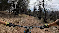
Photos of Plumas County Mountain Bike
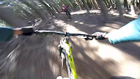
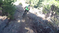
Videos of Plumas County Mountain Bike
trail: Lower Indian Falls Ridge
2:51 |
|
Sep 8, 2024

trail: Mount Washington Trail
3:27 |
60 |
Sep 22, 2021
2:24 |
504 |
May 18, 2019
trail: Mills Peak Trail
0:56 |
104 |
Dec 17, 2018

trail: Berry Creek Connector
11:22 |
64 |
Mar 20, 2017

trail: Berry Creek Connector
13:32 |
62 |
Jan 30, 2017

trail: Berry Creek Connector
9:01 |
60 |
Nov 13, 2016
trail: Mills Peak Trail
3:10 |
382 |
Oct 22, 2015
Current Trail Warnings
| status | trail | date | condition | user | info |
|---|---|---|---|---|---|
| Lower Indian Falls Ridge Mt. Hough | Jun 4, 2026 @ 7:35pm (America/Los_Angeles) Jun 4, 2026 | Dry | snackronym | Dirtbike/Moto many trees down, we cut some but there... |
Recent Trail Reports
Activity Feed
| username | action | type | title | date |
|---|---|---|---|---|
| nclancep | ridden | trail | activity #97527411 | Jun 21, 2026 @ 3:52pm 9 hours |
| NPoggiali | add | karma | activity #97486676 | Jun 21, 2026 @ 8:17am 16 hours |
| Tool4life44 | add | report | activity #97454944 | Jun 20, 2026 @ 9:42pm 1 day |
| jamesworld | wishlist | trail | activity #97436831 | Jun 20, 2026 @ 3:15pm 1 day |
| jamesworld | wishlist | route | activity #97436552 and 1 more | Jun 20, 2026 @ 3:11pm 1 day |
Recent Comments
| username | type | title | comment | date |
|---|---|---|---|---|
| trail | This trail is amazing in the downhill... | Jun 20, 2026 @ 1:38pm 1 day | ||
| report | !D::;3rjxxxhxjxxxhxxjxdx idepends.huhx... | Jun 20, 2026 @ 11:08am 2 days | ||
| trail | So much fun and a great workout, and as... | Jun 11, 2026 @ 8:02am Jun 11, 2026 | ||
| trail | One of the best trails in NorCal. Well done,... | Jun 6, 2026 @ 11:54pm Jun 6, 2026 | ||
| report | D person tuff can always o ,@@ gobut ck | May 9, 2026 @ 4:31pm May 9, 2026 |
Local Badges
-
Mt. Hough Enduro0 awarded -

Epic Mountain Bike Climb 2k0 awarded -

Mountain Biking 100k Badge0 awarded -

Climbing 10k Badge1 awarded -
Climbing 10k Badge0 awarded -
Mountain Biking 100k Badge0 awarded
Bike & Skill Parks
| name | type | city | rating |
|---|---|---|---|
| Portola Bike Park | skill park | Portola | |
| Portola Bike Park | skill park | Portola |
Upcoming Local Events
Local Mountain Biking Directory
-
Sierra Buttes Trail Stewardship
![Sierra Buttes Trail Stewardship]()
-
Everstoke
![Everstoke]()
-
Yuba Expeditions
![Yuba Expeditions]() Bike Shop
Bike Shop
-
Bodfish Bicycles
Bike Shop
Local Mountain Biking Directory
-
Sierra Buttes Trail Stewardship
![Sierra Buttes Trail Stewardship]()
-
Everstoke
![Everstoke]()
-
Yuba ExpeditionsBike Shop
![Yuba Expeditions]()
-
Bodfish BicyclesBike Shop
Activity Type Stats
| activitytype | trails | distance | descent | descent distance | total vertical | rating | global rank | state rank | photos | reports | routes | ridelogs |
|---|---|---|---|---|---|---|---|---|---|---|---|---|
| Mountain Bike | 356 | 1,068 miles | 119,045 ft | 466 miles | 5,351 ft | 382 | 3,261 | 75 | 13,968 | |||
| E-Bike | 283 | 954 miles | 96,883 ft | 408 miles | 5,351 ft | 10 | 2,516 | 43 | 1,750 | |||
| Horse | 287 | 964 miles | 109,970 ft | 430 miles | 6,122 ft | 2,039 | 17 | 3 | ||||
| Hike | 371 | 1,098 miles | 127,224 ft | 481 miles | 6,122 ft | 3 | 3,228 | 16 | 1,596 | |||
| Trail Running | 371 | 1,098 miles | 127,224 ft | 481 miles | 6,122 ft | 3,226 | 17 | 316 | ||||
| Dirtbike/Moto | 217 | 837 miles | 84,131 ft | 363 miles | 5,351 ft | 1 | 1,667 | 13 | 86 | |||
| Observed Trials | 1 | 2 miles | 571 ft | 2 miles | 574 ft | 6 | 2 | |||||
| ATV/ORV/OHV | 133 | 516 miles | 49,255 ft | 219 miles | 5,351 ft | 1,354 | 7 | |||||
| Snowmobile | 5 | 7 miles | 705 ft | 3 miles | 1,824 ft | 710 | 3 | |||||
| Snowshoe | 4 | 7 miles | 705 ft | 3 miles | 1,824 ft | 628 | 49 | |||||
| Downhill Ski | 1 | 2 miles | 571 ft | 2 miles | 574 ft | 94 | 21 | |||||
| Backcountry Ski | 2 | 3 miles | 574 ft | 2 miles | 1,145 ft | 97 | 252 | |||||
| Nordic Ski | 2 | 6 miles | 702 ft | 3 miles | 1,257 ft | 625 | 149 |
Frequently Asked Questions About Plumas County
▼
What are the best places to ride in Plumas County?
Plumas County has 11 areas to explore for mountain biking. The top rated areas are:
▼
What are the highest rated mountain biking trails in Plumas County?
The highest rated mountain biking trails in Plumas County are:
- Everflow (4.4/5)
- Mount Hough #1 (4.4/5)
- Mount Hough Tollgate Rd. to train tracks (4.4/5)
- Mount Hough #4 Rhinehart Meadow through climbing section (4.3/5)
- Lake Davis Trail (4.3/5)
▼
What is the best time of the year to ride in Plumas County?
Based on ride log data, the most popular months to ride in Plumas County are:
- July (142 activities)
- June (123 activities)
- October (120 activities)
▼
What is the longest trail in Plumas County?
The longest trail in Plumas County is Lake Almanor Recreation Trail at 10.9 miles. View all trails sorted by distance.
Activities
Trails
Points of Interest
- Camp Spot #4 Camping
- Steep Rocky Section TTF
- Jump line option - look before you leap TTF
- Snake Lake Campground Camping
- Red Bridge Campground Camping
- [swimming] Graeagle Mill Pond Other
- Double track road to creek view Sight
- Dylan's gap jumps TTF
- Dixie Mt Fire Lookout Viewpoint
- Smith Peak Fire Lookout Sight
- Mount Ingalls (8,340 ft)
- Dixie Mountain (8,323 ft)
- Adams Peak (8,182 ft)
- By WillieJacobsz
 Trailforks SBP SWW & contributors
 - Admins: jpmcghee, sanfret, brianpetry, TheAngryTomato, SBTS
- #61089 - 1,655 views
- plumas county activity log | embed map of Plumas County mountain bike trails | plumas county mountain biking points of interest
Downloading of trail gps tracks in kml & gpx formats is enabled for Plumas County.
You must login to download files.