close
-
Layers w
- Weather Layers
- Pro
- Pro
- Pro
- Pro
- Pro
- Pro
- More Layers
- Pro
- Pro
- Pro
- Pro
-
Upgrade to

3D
Trail Conditions
- Unknown
- Snow Groomed
- Snow Packed
- Snow Covered
- Snow Cover Partial
- Freeze/thaw Cycle
- Icy
- Prevalent Mud
- Wet
- Variable
- Ideal
- Dry
- Very Dry
Trail Flow (Ridden Direction)
Trailforks scans users ridelogs to determine the most popular direction each trail is ridden. A good flowing trail network will have most trails flowing in a single direction according to their intension.
The colour categories are based on what percentage of riders are riding a trail in its intended direction.
The colour categories are based on what percentage of riders are riding a trail in its intended direction.
- > 96%
- > 90%
- > 80%
- > 70%
- > 50%
- < 50%
- bi-directional trail
- no data
Trail Last Ridden
Trailforks scans ridelogs to determine the last time a trail was ridden.
- < 2 days
- < 1 week
- < 2 weeks
- < 1 month
- < 6 months
- > 6 months
Trail Ridden Direction
The intended direction a trail should be ridden.
- Downhill Only
- Downhill Primary
- Both Directions
- Uphill Primary
- Uphill Only
- One Direction
Contribute Details
Colors indicate trail is missing specified detail.
- Description
- Photos
- Description & Photos
- Videos
Trail Popularity ?
Trailforks scans ridelogs to determine which trails are ridden the most in the last 9 months.
Trails are compared with nearby trails in the same city region with a possible 25 colour shades.
Think of this as a heatmap, more rides = more kinetic energy = warmer colors.
- most popular
- popular
- less popular
- not popular
ATV/ORV/OHV Filter
Max Vehicle Width
inches
US Cell Coverage
Legend

Radar Time
Activity Recordings
Trailforks uses anonymized public activity data.
?
Activity Recordings
Trailforks uses anonymized public activity data.
?
Personal Heatmap
▶
Activity Types
all
/
none
▶
Options
2
Date range
month
–
Winter Trails
Warning
A routing network for winter maps does not exist. Selecting trails using the winter trails layer has been disabled.
Missing Trails
Most Popular
Least Popular
Trails are colored based on popularity. The more popular a trail is, the more red. Less popular trails trend towards green.
Jump Magnitude Heatmap
Heatmap of where riders jump on trails. Zoom in to see individual jumps, click circles to view jump details.
BC Backroad Status
![map legend]()
Service Road Atlas is a free to use, community-driven service for viewing and creating reports on the numerous back-country service roads around B.C. and Alberta.

Slope Aspect
Direction the slope faces
Trails Deemphasized
Trails are shown in grey.
Only show trails with no bike usage.
Suggested Layers
Based on selected activity type
Save the current map location and zoom level as your default home location whenever this page is loaded.
Save
No description for Pocatello has been added yet!
Login or register to submit one.
Region Supporters & Maintainers
Activities Click to view
- Mountain Bike
223 trails
- E-Bike
162 trails
- Gravel Bike
0 trails
- Adaptive Bike
0 trails
- Winter Fat Bike
0 trails
- Horse
118 trails
- Hike
227 trails
- Trail Running
228 trails
- Dirtbike/Moto
40 trails
- ATV/ORV/OHV
13 trails
Region Details
- 32
- 24
- 42
- 85
- 28
- 2
Region Status
Open as of 13 hoursStats
- Avg Trail Rating
- Trails (view details)
- 228
- Trails Mountain Bike
- 223
- Trails E-Bike
- 162
- Trails Horse
- 118
- Trails Hike
- 228
- Trails Trail Running
- 228
- Trails Dirtbike/Moto
- 40
- Trails Observed Trials
- 2
- Trails ATV/ORV/OHV
- 13
- Total Distance
- 341 miles
- Total Descent
- 65,602 ft
- Total Vertical
- 4,285 ft
- Highest Trailhead
- 8,686 ft
- Reports
- 1,271
- Photos
- 814
- Ridden Counter
- 36,300
Sub Regions
-
Blackrock Canyon
- 1
- 3
-
City Creek
- 16
- 31
- 12
- 1
-
Gibson Jack
- 3
- 15
- 7
- 1
-
Pioneer Ridge
- 10
- 10
- 3
-
Portneuf Greenway
- 23
- 5
-
Scout Mountain
- 3
- 25
- 6
Popular Pocatello Mountain Biking Trails
• 95 ★ 4.0 • 2 miles • 489 ft • 658 •
A beautiful ride in every season. As you wind up this single-track that parallels the creek, you will cross back and forth over 10 wooden bridges. The trail is a mix of hard-packed dirt with some rocky sections as well as sections with...
• 100 ★ 3.9 • 1 mile • 377 ft • 643 •
There are 8 more wooden bridges as you continue on this great ride along the creek and through the trees. Not quite as steep as . Look out for hikers, runners, and dogs.
• 100 ★ 4.3 • 2,907 ft • 8 ft • 639 •
Curvy, fast. Gets overgrown in late summer. 2019 - Now a flow trail with berms, rollers, and small table tops. Upper half of redone by two Eagle projects. Projects approved by City of Pocatello Outdoor Recreation department.
• 100 ★ 4.0 • 4,554 ft • 0 ft • 638 •
Downhill bikes only. Roller coaster with berms. If the dips get too big, you can onto Lifeflight at crossover points. Note that the trail overlaps in places with Lifeflight which is open to all with 2-way traffic. During these overlaps,...
• 100 ★ 4.4 • 2,463 ft • 12 ft • 592 •
This trail runs alongside but with more twists and dips.
Pocatello Mountain Bike Routes
★ 5.0 • 31 miles • 3,894 ft • 8 • Point to Point •
Ride starting at Scout Mountain Campground with plenty of descending and climbing through Mink Creek and...
★ 5.0 • 38 miles • 5,624 ft • 6 • Loop •
Official course for Pocatello fall 60k ultra
★ 5.0 • 14 miles • 2,495 ft • 2 • Loop •
Just a basic route to take you from the trailhead, up Gibson Jack, around Elk Meadows, then up and out...
★ 4.0 • 9 miles • 1,535 ft • 2 •
Fun loop up mink creek, connect to Birthday, then back down mink creek.
★ 5.0 • 11 miles • 2,589 ft • 3 • Loop •
The classic scout mountain loop
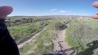
Photos of Pocatello Mountain Bike
Videos of Pocatello Mountain Bike
trail: Revine
0:12 |
27 |
Oct 6, 2022
trail: Sullivans
0:12 |
40 |
Jun 10, 2022

trail: Crestline
0:13 |
155 |
Dec 3, 2020
trail: Crestline
0:13 |
83 |
Oct 16, 2020
trail: Gibson Jack
0:43 |
163 |
May 22, 2020
trail: 911
2:32 |
552 |
Jun 9, 2019
trail: 911
3:48 |
251 |
Feb 22, 2016

trail: Roller Coaster
0:08 |
338 |
Jun 14, 2015
Recent Trail Reports
| status | trail | date | condition | info | user |
|---|---|---|---|---|---|
| Mormon Canyon Trail | Jun 11, 2026 @ 8:09am (America/Boise) Jun 11, 2026 | Snow Cover Partial | Lisaplescia | ||
| Crystal Creek - North | May 29, 2026 @ 10:31am (America/Boise) May 29, 2026 | Ideal | mtengaio | ||
| Down the Chimney | May 27, 2026 @ 4:41pm (America/Boise) May 27, 2026 | Unknown | NoonOkXEIC | ||
| Scout | May 18, 2026 @ 6:42am (America/Boise) May 18, 2026 | Dry | theN8 | ||
| Mushroom | May 18, 2026 @ 6:42am (America/Boise) May 18, 2026 | Ideal | theN8 | ||
| Sap Tree - Lower | May 18, 2026 @ 6:42am (America/Boise) May 18, 2026 | Prevalent Mud | theN8 | ||
| Mushroom Connector | May 18, 2026 @ 6:42am (America/Boise) May 18, 2026 | Ideal | theN8 | ||
| City Creek - Upper | May 18, 2026 @ 6:42am (America/Boise) May 18, 2026 | Ideal | theN8 | ||
| City Creek - Lower | May 18, 2026 @ 6:42am (America/Boise) May 18, 2026 | Ideal | theN8 | ||
| Tipsy Cow | May 10, 2026 @ 6:44am (America/Boise) May 10, 2026 | Ideal | salkoreth |
Activity Feed
| username | action | type | title | date |
|---|---|---|---|---|
| FSqTOn | wishlist | trail | activity #97227720 and 1 more | Jun 17, 2026 @ 7:48pm 13 hours |
| kgonzored1 | wishlist | route | activity #97227095 | Jun 17, 2026 @ 7:35pm 13 hours |
| FSqTOn | add | report | activity #97227080 | Jun 17, 2026 @ 7:35pm 13 hours |
| kgonzored1 | wishlist | trail | activity #97226988 | Jun 17, 2026 @ 7:34pm 13 hours |
| kgonzored1 | wishlist | trail | activity #97226508 and 1 more | Jun 17, 2026 @ 7:24pm 13 hours |
Recent Comments
| username | type | title | comment | date |
|---|---|---|---|---|
| trail | Blind Spring Cutoff trail to East Fork trail... | May 25, 2026 @ 2:35pm May 25, 2026 | ||
| trail | Trail 109 Lead Draw to the west of as-shown... | Oct 15, 2025 @ 2:43pm Oct 15, 2025 | ||
| trail | Fun trail.. a bit overgrown in a few areas,... | Sep 10, 2025 @ 6:32pm Sep 10, 2025 | ||
| trail | Don't do it. This looks like it was built by... | Jul 17, 2025 @ 11:18am Jul 17, 2025 | ||
| trail | Best rock garden in SE Idaho for sure. Get... | Jul 6, 2025 @ 11:54am Jul 6, 2025 |
Local Badges
-

Completionist0 awarded -

Big Ride 30k2,159 awarded -

Epic Ride 50k925 awarded -

Top 10 Trails7 awarded -
Completionist0 awarded -
Completionist0 awarded
Bike & Skill Parks
| name | type | city | rating |
|---|---|---|---|
| Pocatello TMX | skill park | Pocatello |
Activity Type Stats
| activitytype | trails | distance | descent | descent distance | total vertical | rating | global rank | state rank | photos | reports | routes | ridelogs |
|---|---|---|---|---|---|---|---|---|---|---|---|---|
| Mountain Bike | 223 | 332 miles | 63,688 ft | 153 miles | 4,285 ft | #269 | #96 | 667 | 1,286 | 27 | 33,963 | |
| E-Bike | 162 | 233 miles | 44,413 ft | 112 miles | 4,278 ft | #433 | #708 | 7 | 1,175 | 6 | 2,240 | |
| Horse | 118 | 181 miles | 38,192 ft | 94 miles | 3,583 ft | #119 | #380 | 276 | 1 | 12 | ||
| Hike | 227 | 336 miles | 62,864 ft | 153 miles | 4,285 ft | #336 | #159 | 121 | 1,278 | 6 | 2,700 | |
| Trail Running | 228 | 336 miles | 62,864 ft | 153 miles | 4,285 ft | #134 | #61 | 57 | 1,278 | 14 | 5,722 | |
| Dirtbike/Moto | 40 | 93 miles | 18,035 ft | 52 miles | 3,245 ft | #282 | #136 | 263 | 2 | 59 | ||
| Observed Trials | 2 | 10 miles | 2,799 ft | 5 miles | 1,909 ft | 2 | 9 | |||||
| ATV/ORV/OHV | 13 | 61 miles | 11,033 ft | 37 miles | 2,231 ft | #341 | #101 | 260 | 20 |
Frequently Asked Questions About Pocatello
▼
What are the best places to ride in Pocatello?
Pocatello has 7 areas to explore for mountain biking. The top rated areas are:
▼
What are the highest rated mountain biking trails in Pocatello?
The highest rated mountain biking trails in Pocatello are:
- Windago (4.4/5)
- Roller Coaster (4.3/5)
- Gutterball (4.2/5)
- Down the Chimney (4.2/5)
- Birthday (4.2/5)
▼
What is the best time of the year to ride in Pocatello?
Based on ride log data, the most popular months to ride in Pocatello are:
- July (520 activities)
- June (419 activities)
- August (369 activities)
▼
Where can I park to ride in Pocatello?
There are 32 parking locations listed in Pocatello. The most popular parking spots are:
- City Creek Lower Parking Lot
- Limited Parking
- Limited Parking
- Limited Parking
- Centennial Park Parking Lot
Activities
Trails
- By canadaka
 Trailforks & contributors
 - Admins: POR, noplacefamous, jntidaho
- #4959 - 35,566 views
- pocatello activity log | embed map of Pocatello mountain bike trails | pocatello mountain biking points of interest
Downloading of trail gps tracks in kml & gpx formats is enabled for Pocatello.
You must login to download files.