close
-
Layers w
- Weather Layers
- Pro
- Pro
- Pro
- Pro
- Pro
- Pro
- More Layers
- Pro
- Pro
- Pro
- Pro
-
Upgrade to

3D
Trail Conditions
- Unknown
- Snow Groomed
- Snow Packed
- Snow Covered
- Snow Cover Partial
- Freeze/thaw Cycle
- Icy
- Prevalent Mud
- Wet
- Variable
- Ideal
- Dry
- Very Dry
Trail Flow (Ridden Direction)
Trailforks scans users ridelogs to determine the most popular direction each trail is ridden. A good flowing trail network will have most trails flowing in a single direction according to their intension.
The colour categories are based on what percentage of riders are riding a trail in its intended direction.
The colour categories are based on what percentage of riders are riding a trail in its intended direction.
- > 96%
- > 90%
- > 80%
- > 70%
- > 50%
- < 50%
- bi-directional trail
- no data
Trail Last Ridden
Trailforks scans ridelogs to determine the last time a trail was ridden.
- < 2 days
- < 1 week
- < 2 weeks
- < 1 month
- < 6 months
- > 6 months
Trail Ridden Direction
The intended direction a trail should be ridden.
- Downhill Only
- Downhill Primary
- Both Directions
- Uphill Primary
- Uphill Only
- One Direction
Contribute Details
Colors indicate trail is missing specified detail.
- Description
- Photos
- Description & Photos
- Videos
Trail Popularity ?
Trailforks scans ridelogs to determine which trails are ridden the most in the last 9 months.
Trails are compared with nearby trails in the same city region with a possible 25 colour shades.
Think of this as a heatmap, more rides = more kinetic energy = warmer colors.
- most popular
- popular
- less popular
- not popular
ATV/ORV/OHV Filter
Max Vehicle Width
inches
US Cell Coverage
Legend

Radar Time
Activity Recordings
Trailforks uses anonymized public activity data.
?
Activity Recordings
Trailforks uses anonymized public activity data.
?
Personal Heatmap
▶
Activity Types
all
/
none
▶
Options
2
Date range
month
–
Winter Trails
Warning
A routing network for winter maps does not exist. Selecting trails using the winter trails layer has been disabled.
Missing Trails
Most Popular
Least Popular
Trails are colored based on popularity. The more popular a trail is, the more red. Less popular trails trend towards green.
Jump Magnitude Heatmap
Heatmap of where riders jump on trails. Zoom in to see individual jumps, click circles to view jump details.
BC Backroad Status
![map legend]()
Service Road Atlas is a free to use, community-driven service for viewing and creating reports on the numerous back-country service roads around B.C. and Alberta.

Slope Aspect
Direction the slope faces
Trails Deemphasized
Trails are shown in grey.
Only show trails with no bike usage.
Suggested Layers
Based on selected activity type
Save the current map location and zoom level as your default home location whenever this page is loaded.
Save
No description for Podlaskie has been added yet!
Login or register to submit one.
This region uses the Uk/Euro style trail grading system.
Region Details
- 15
- 5
- 4
- 5
Stats
- Avg Trail Rating
- Trails (view details)
- 29
- Trails Mountain Bike
- 29
- Trails E-Bike
- 16
- Trails Horse
- 1
- Trails Hike
- 22
- Trails Trail Running
- 22
- Total Distance
- 26 miles
- Total Descent
- 1,081 ft
- Total Vertical
- 433 ft
- Highest Trailhead
- 749 ft
- Reports
- 7
- Photos
- 79
- Ridden Counter
- 249
Sub Regions
- Powiat Augustowski (1)
- Płaska (1)
- Płaska (1)
- Powiat Białostocki (13)
- Białystok (3)
- Las Pietrasze (2)
- Supraśl (10)
- Ogrodniczki (9)
- Białystok (3)
- Powiat Bielski (Podlaskie) (3)
- Bielsk Podlaski (1)
- Bielsk Podlaski (1)
- Powiat Grajewski (1)
- Rajgród (1)
- Rajgród (1)
- Powiat Hajnowski (1)
- Kleszczele (1)
- Kleszczele (1)
- Powiat Kolneński (2)
- Kolno (2)
- Kolno (2)
- Powiat Moniecki (1)
- Trzcianne (1)
- Trzcianne (1)
- Powiat Sejneński (1)
- Giby (1)
- Giby (1)
- Powiat Siemiatycki (1)
- Drohiczyn (1)
- Drohiczyn (1)
- Powiat Sokólski (1)
- Suchowola (1)
- Suchowola (1)
- Powiat Suwalski (1)
- Jeleniewo (1)
- Jeleniewo (1)
- Powiat Wysokomazowiecki (1)
- Powiat Zambrowski (1)
- Zambrow (1)
- Zambrow (1)
- Powiat Łomżyński (1)
- Łomża (1)
- Łomża (1)
Popular Podlaskie Mountain Biking Trails
• 100 ★ 0.0 • 1 mile • 55 ft • 18 • • hike
Leśna, trochę korzenna ścieżka z Białowieży do rezerwatu pokazowego żubrów. Żółty szlak pieszy.
• 85 ★ 5.0 • 899 ft • 0 ft • 17 •
Ciekawy zjazd - zawiera siodło, bandy w wąwozie, dropa i ściankę z drewnianych belek po których trzeba skręcić ostro w prawo. Kończy się w punkcie w którym podczas Pucharu Polski XCO Ogrodniczki 2025 mieścił się box.
• 70 ★ 5.0 • 758 ft • 0 ft • 17 •
Bardzo ciekawy, chyba najtrudniejszy zjazd na trasie Pucharu Polski XCO Ogrodniczki 2025. Najpierw pokonujemy na zjeździe kilka dropów pod rząd, potem czeka nas krótki podjazd, by w lewo skręcić na nieco większego dropa na...
• 60 ★ 5.0 • 1,030 ft • 0 ft • 16 •
Ścieżka zjazdowa. Zaczyna się slalomem w piasku, a potem wpada do lasu, gdzie trzeba przejechać lub przeskoczyć dwie podwójne belki. Część trasy Pucharu Polski XCO Ogrodniczki 2025.
• 95 ★ 4.0 • 581 ft • 0 ft • 16 •
Szybki zjazd z bandami w postaci drewnianych "mostków". Na dole coś w rodzaju pumptracka, ale raczej z funkcją spowolnienia zawodnika. Na końcu wyskok z "trumny", za którą jest dziura. Część trasy Pucharu Polski XCO Ogrodniczki...
• 20 ★ 0.0 • 1,772 ft • 0 ft • 15 •
Less popular green difficulty singletrack. This mountain bike primary trail and has a easy overall physical rating with a 0 ft green climb. On average it takes 1 minutes to complete this trail.
• 100 ★ 5.0 • 1,289 ft • 0 ft • 7 •
Popular red difficulty singletrack. This mountain bike primary trail can be used downhill primary and has a moderate overall physical rating with a 0 ft green climb. It features berm, jump, gap jump and other. Trail visibility is always easy to follow. On average it takes 21 minutes to complete this trail.
Podlaskie Mountain Bike Routes
30 miles • 1,069 ft • 0 • Loop •
Trasa wmiare łatwa, ale są fragmenty z stromymi zjazdami i podjazdami, więc każdy znajdzie coś dla siebie
15 miles • 1,030 ft • 0 • Loop •
Maratony Kresowe 2020 track - interesting ride around Mielnik
3 miles • 323 ft • 0 • Loop • Race •
Trasa wyścigu w Ogrodniczkach, w ramach Pucharu Polski XCO 2023.
2 miles • 348 ft • 0 • Loop • Race •
Trasa Pucharu Polski XCO 2025 w Ogrodniczkach.
Photos of Podlaskie Mountain Bike
Videos of Podlaskie Mountain Bike
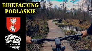
trail: Leśna Ambona
5:24 |
282 |
May 16, 2021 , Supraśl
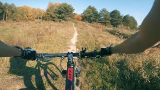
trail: Hopki
0:29 |
1193 |
Nov 27, 2018 , Białystok
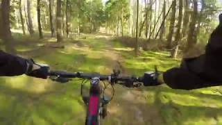
trail: Leśna Ambona
0:45 |
416 |
Oct 24, 2018 , Supraśl
Recent Trail Reports
| status | trail | date | condition | info | user |
|---|---|---|---|---|---|
| Anton Białystok | Jan 14, 2023 @ 1:11am Jan 14, 2023 | Wet | PiotrJaniak | ||
| Leśny Flow Kolno | Oct 14, 2022 @ 11:03pm Oct 14, 2022 | Unknown | kobes-bike | ||
| Leśna Ambona Supraśl | Aug 15, 2020 @ 2:14am Aug 15, 2020 | Very Dry | MarekKosa | ||
| Hopki Las Pietrasze | May 30, 2020 @ 1:57am May 30, 2020 | Variable | PiotrJaniak | ||
| Echo Lasu Wysokie Mazowieckie | Oct 4, 2018 @ 12:21pm Oct 4, 2018 | Dry | majkelMTB |
Activity Feed
| username | action | type | title | date |
|---|---|---|---|---|
| kajetan1 | update | route | activity #74094309 and 1 more | Jun 19, 2025 @ 4:27am Jun 19, 2025 |
| kajetan1 | update | route | activity #74094286 | Jun 19, 2025 @ 4:27am Jun 19, 2025 |
| kajetan1 | update | trail | activity #74094121 | Jun 19, 2025 @ 4:23am Jun 19, 2025 |
| kajetan1 | update | trail | activity #74093841 | Jun 19, 2025 @ 4:15am Jun 19, 2025 |
| kajetan1 | update | trail | activity #74093722 | Jun 19, 2025 @ 4:12am Jun 19, 2025 |
Bike & Skill Parks
| name | type | city | rating |
|---|---|---|---|
| Pumptrack Kolno | skill park | Kolno | |
| Pumptrack & Dirtpark Suwałki | skill park | Suwałki |
Activity Type Stats
| activitytype | trails | distance | descent | descent distance | total vertical | rating | global rank | state rank | photos | reports | routes | ridelogs |
|---|---|---|---|---|---|---|---|---|---|---|---|---|
| Mountain Bike | 29 | 26 miles | 1,079 ft | 9 miles | 433 ft | 79 | 7 | 4 | 9,330 | |||
| E-Bike | 16 | 5 miles | 528 ft | 2 miles | 210 ft | 6 | 2 | 94 | ||||
| Horse | 1 | 7 miles | 131 ft | 3 miles | 49 ft | 1 | ||||||
| Hike | 22 | 24 miles | 696 ft | 8 miles | 433 ft | 6 | 315 | |||||
| Trail Running | 22 | 24 miles | 696 ft | 8 miles | 433 ft | 6 | 1 | 18 |
Activities
Trails
- By brenthillier
 NSMBA TRAILFORKS & contributors
 - Admins: PMBA, Poland
- #10672 - 3,592 views
- podlaskie activity log | embed map of Podlaskie mountain bike trails | podlaskie mountain biking points of interest
Downloading of trail gps tracks in kml & gpx formats is enabled for Podlaskie.
You must login to download files.