close
-
Layers w
- Weather Layers
- Pro
- Pro
- Pro
- Pro
- Pro
- Pro
- More Layers
- Pro
- Pro
- Pro
- Pro
-
Upgrade to

3D
Trail Conditions
- Unknown
- Snow Groomed
- Snow Packed
- Snow Covered
- Snow Cover Partial
- Freeze/thaw Cycle
- Icy
- Prevalent Mud
- Wet
- Variable
- Ideal
- Dry
- Very Dry
Trail Flow (Ridden Direction)
Trailforks scans users ridelogs to determine the most popular direction each trail is ridden. A good flowing trail network will have most trails flowing in a single direction according to their intension.
The colour categories are based on what percentage of riders are riding a trail in its intended direction.
The colour categories are based on what percentage of riders are riding a trail in its intended direction.
- > 96%
- > 90%
- > 80%
- > 70%
- > 50%
- < 50%
- bi-directional trail
- no data
Trail Last Ridden
Trailforks scans ridelogs to determine the last time a trail was ridden.
- < 2 days
- < 1 week
- < 2 weeks
- < 1 month
- < 6 months
- > 6 months
Trail Ridden Direction
The intended direction a trail should be ridden.
- Downhill Only
- Downhill Primary
- Both Directions
- Uphill Primary
- Uphill Only
- One Direction
Contribute Details
Colors indicate trail is missing specified detail.
- Description
- Photos
- Description & Photos
- Videos
Trail Popularity ?
Trailforks scans ridelogs to determine which trails are ridden the most in the last 9 months.
Trails are compared with nearby trails in the same city region with a possible 25 colour shades.
Think of this as a heatmap, more rides = more kinetic energy = warmer colors.
- most popular
- popular
- less popular
- not popular
ATV/ORV/OHV Filter
Max Vehicle Width
inches
US Cell Coverage
Legend

Radar Time
Activity Recordings
Trailforks uses anonymized public activity data.
?
Activity Recordings
Trailforks uses anonymized public activity data.
?
Personal Heatmap
▶
Activity Types
all
/
none
▶
Options
2
Date range
month
–
Winter Trails
Warning
A routing network for winter maps does not exist. Selecting trails using the winter trails layer has been disabled.
Missing Trails
Most Popular
Least Popular
Trails are colored based on popularity. The more popular a trail is, the more red. Less popular trails trend towards green.
Jump Magnitude Heatmap
Heatmap of where riders jump on trails. Zoom in to see individual jumps, click circles to view jump details.
BC Backroad Status
![map legend]()
Service Road Atlas is a free to use, community-driven service for viewing and creating reports on the numerous back-country service roads around B.C. and Alberta.

Slope Aspect
Direction the slope faces
Trails Deemphasized
Trails are shown in grey.
Only show trails with no bike usage.
Suggested Layers
Based on selected activity type
Save the current map location and zoom level as your default home location whenever this page is loaded.
SaveMap defaulted to winter mode.
No description for Pogno has been added yet!
Login or register to submit one.
Links
This region uses the Uk/Euro style trail grading system.
Activities Click to view
- Mountain Bike
20 trails
- E-Bike
7 trails
- Gravel Bike
0 trails
- Adaptive Bike
0 trails
- Winter Fat Bike
1 trails
- Hike
13 trails
- Trail Running
13 trails
Region Details
- 5
- 11
Region Status
Open as of Jun 11, 2026Stats
- Avg Trail Rating
- Trails (view details)
- 17
- Trails Mountain Bike
- 20
- Trails E-Bike
- 7
- Trails Winter Fat Bike
- 1
- Trails Hike
- 13
- Trails Trail Running
- 13
- Total Distance
- 23 miles
- Total Descent
- 9,378 ft
- Total Vertical
- 1,742 ft
- Highest Trailhead
- 3,070 ft
- Reports
- 537
- Photos
- 23
- Ridden Counter
- 4,033
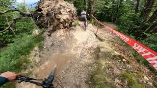
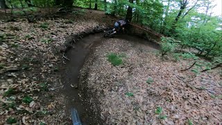
Popular Pogno Mountain Biking Trails
• 100 ★ 4.2 • 2 miles • 19 ft • 437 •
Highly rated popular blue difficulty singletrack. This mountain bike primary trail with a 19 ft blue climb. On average it takes 21 minutes to complete this trail.
• 95 ★ 4.6 • 1 mile • 12 ft • 388 •
Highly rated popular blue difficulty singletrack. This mountain bike primary trail can be used downhill primary with a 12 ft blue climb. On average it takes 9 minutes to complete this trail.
• 40 ★ 2.0 • 1 mile • 65 ft • 196 •
Mainly flowly trails, short uphill ramp, little bit dusty at the end. It cross many times an access road and also a small river. Used for 3th stage on championship "4enduro" in 2017 and "Enduro dei Gufi" in 2016.
• 30 ★ 4.5 • 1 mile • 8 ft • 77 •
Less popular blue difficulty singletrack. This mountain bike primary trail can be used downhill only and has a moderate overall physical rating with a 8 ft blue climb. Trail visibility is always easy to follow. On average it takes 26 minutes to complete this trail.
• ★ 4.0 • 2,336 ft • 21 ft • 56 •
Blue difficulty singletrack. This mountain bike primary trail can be used both directions and has a moderate overall physical rating with a 21 ft green climb. It features a-frame, bridge and skinny. Adaptive MTB rating: amtb green. Trail visibility is always easy to follow.
• ★ 0.0 • 1,660 ft • 12 ft • 49 •
Blue difficulty singletrack. This mountain bike primary trail can be used downhill only and has a moderate overall physical rating with a 12 ft green climb. Adaptive MTB rating: amtb blue. Trail visibility is always easy to follow.
Photos of Pogno Mountain Bike
Videos of Pogno Mountain Bike

Recent Trail Reports
| status | trail | date | condition | info | user |
|---|---|---|---|---|---|
| Elicotteri PS1 2018 | Jun 12, 2026 @ 7:35am (Europe/Vaduz) Jun 11, 2026 | Ideal | Trimbax | ||
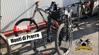
| Monti di Prerro | Jun 12, 2026 @ 7:35am (Europe/Vaduz) Jun 11, 2026 | Ideal | Trimbax | ||
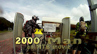
| 2000 | Jun 12, 2026 @ 7:35am (Europe/Vaduz) Jun 11, 2026 | Ideal | Trimbax | ||
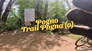
| Pogna | Jun 12, 2026 @ 7:35am (Europe/Vaduz) Jun 11, 2026 | Variable | Trimbax | ||
| E-Carbon low | Jun 12, 2026 @ 7:35am (Europe/Vaduz) Jun 11, 2026 | Ideal | Trimbax | ||
| Monti di Prerro | May 17, 2026 @ 10:38am (Europe/Vaduz) May 17, 2026 | Ideal | mirkosaydomimi | ||
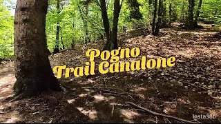
| Canalone | May 17, 2026 @ 10:38am (Europe/Vaduz) May 17, 2026 | Ideal | mirkosaydomimi | ||
| Elicotteri Start | May 17, 2026 @ 10:38am (Europe/Vaduz) May 17, 2026 | Ideal | mirkosaydomimi | ||
| E-Carbon High | May 1, 2026 @ 9:55am (Europe/Rome) May 1, 2026 | Variable | Massimiliano64 | ||
| Direttissima Ripid Monti di Prerro | May 1, 2026 @ 9:55am (Europe/Rome) May 1, 2026 | Ideal | Massimiliano64 |
Activity Feed
| username | action | type | title | date |
|---|---|---|---|---|
| jogw | ridden | trail | activity #97246882 | Jun 18, 2026 @ 6:11am 3 days |
| Trimbax | add | report | activity #96858167 and 4 more | Jun 13, 2026 @ 3:12am Jun 13, 2026 |
| dovahseg | add | report | activity #96526133 | Jun 8, 2026 @ 1:23am Jun 8, 2026 |
| JancNcsTa | wishlist | trail | activity #95617862 | May 27, 2026 @ 12:32am May 27, 2026 |
| fabio77 | difficultyvote | trail | activity #95469011 | May 25, 2026 @ 12:22am May 25, 2026 |
Recent Comments
| username | type | title | comment | date |
|---|---|---|---|---|
| trail | bellissimo! Top trail | May 14, 2026 @ 7:08am May 14, 2026 | ||
| trail | Good an interesting e-bike uphill, not good... | Oct 2, 2025 @ 4:39am Oct 2, 2025 | ||
| trail | Complimenti veramente ai Gufi, per l'impegno... | Jan 15, 2025 @ 8:34am Jan 15, 2025 | ||
| trail | Nach ca. 1/3 gesperrt. Geht links in Monte di... | Nov 5, 2024 @ 2:32am Nov 5, 2024 | ||
| trail | Percorso oggi 23 dicembre ottime condizioni... | Dec 23, 2023 @ 12:07pm Dec 23, 2023 |
Local Badges
-

Epic Mountain Bike Climb 2k66 awarded -

Climbing 10k Badge23 awarded -

Mountain Biking 100k Badge1 awarded -

Epic Ride Descent 2k66 awarded -

Descent 10k Badge24 awarded -

Descent 100k Badge1 awarded
Activity Type Stats
| activitytype | trails | distance | descent | descent distance | total vertical | rating | global rank | state rank | photos | reports | routes | ridelogs |
|---|---|---|---|---|---|---|---|---|---|---|---|---|
| Mountain Bike | 20 | 23 miles | 9,377 ft | 11 miles | 1,742 ft | #4,224 | #265 | 22 | 534 | 3,509 | ||
| E-Bike | 7 | 2 miles | 135 ft | 2,385 ft | 889 ft | #891 | #113 | 1 | 395 | 669 | ||
| Winter Fat Bike | 1 | #166 | #251 | |||||||||
| Hike | 13 | 21 miles | 7,598 ft | 9 miles | 1,742 ft | #6,416 | #329 | 485 | 83 | |||
| Trail Running | 13 | 21 miles | 7,598 ft | 9 miles | 1,742 ft | #5,848 | #308 | 485 | 23 |
Frequently Asked Questions About Pogno
▼
What are the highest rated mountain biking trails in Pogno?
The highest rated mountain biking trails in Pogno are:
- 2000 (4.3/5)
- Monti di Prerro (4.2/5)
- Canalone (4.1/5)
- Pogna (4.1/5)
- E-Carbon High (4/5)
▼
What is the best time of the year to ride in Pogno?
Based on ride log data, the most popular months to ride in Pogno are:
- October (17 activities)
- November (10 activities)
- September (8 activities)
▼
Where can I park to ride in Pogno?
There are 1 parking locations listed in Pogno. The most popular parking spots are:
▼
What is the longest trail in Pogno?
The longest trail in Pogno is Canalone at 1.8 miles. View all trails sorted by distance.
Activities
Trails
- By cheorch
 & contributors
 - Admins: silviu86, adessoomaipiu
- #9451 - 9,429 views
- pogno activity log | embed map of Pogno mountain bike trails | pogno mountain biking points of interest
Downloading of trail gps tracks in kml & gpx formats is enabled for Pogno.
You must login to download files.