close
-
Layers w
- Weather Layers
- Pro
- Pro
- Pro
- Pro
- Pro
- Pro
- More Layers
- Pro
- Pro
- Pro
- Pro
-
Upgrade to

3D
Trail Conditions
- Unknown
- Snow Groomed
- Snow Packed
- Snow Covered
- Snow Cover Partial
- Freeze/thaw Cycle
- Icy
- Prevalent Mud
- Wet
- Variable
- Ideal
- Dry
- Very Dry
Trail Flow (Ridden Direction)
Trailforks scans users ridelogs to determine the most popular direction each trail is ridden. A good flowing trail network will have most trails flowing in a single direction according to their intension.
The colour categories are based on what percentage of riders are riding a trail in its intended direction.
The colour categories are based on what percentage of riders are riding a trail in its intended direction.
- > 96%
- > 90%
- > 80%
- > 70%
- > 50%
- < 50%
- bi-directional trail
- no data
Trail Last Ridden
Trailforks scans ridelogs to determine the last time a trail was ridden.
- < 2 days
- < 1 week
- < 2 weeks
- < 1 month
- < 6 months
- > 6 months
Trail Ridden Direction
The intended direction a trail should be ridden.
- Downhill Only
- Downhill Primary
- Both Directions
- Uphill Primary
- Uphill Only
- One Direction
Contribute Details
Colors indicate trail is missing specified detail.
- Description
- Photos
- Description & Photos
- Videos
Trail Popularity ?
Trailforks scans ridelogs to determine which trails are ridden the most in the last 9 months.
Trails are compared with nearby trails in the same city region with a possible 25 colour shades.
Think of this as a heatmap, more rides = more kinetic energy = warmer colors.
- most popular
- popular
- less popular
- not popular
ATV/ORV/OHV Filter
Max Vehicle Width
inches
US Cell Coverage
Legend

Radar Time
Activity Recordings
Trailforks uses anonymized public activity data.
?
Activity Recordings
Trailforks uses anonymized public activity data.
?
Personal Heatmap
▶
Activity Types
all
/
none
▶
Options
2
Date range
month
–
Winter Trails
Warning
A routing network for winter maps does not exist. Selecting trails using the winter trails layer has been disabled.
Missing Trails
Most Popular
Least Popular
Trails are colored based on popularity. The more popular a trail is, the more red. Less popular trails trend towards green.
Jump Magnitude Heatmap
Heatmap of where riders jump on trails. Zoom in to see individual jumps, click circles to view jump details.
BC Backroad Status
![map legend]()
Service Road Atlas is a free to use, community-driven service for viewing and creating reports on the numerous back-country service roads around B.C. and Alberta.

Slope Aspect
Direction the slope faces
Trails Deemphasized
Trails are shown in grey.
Only show trails with no bike usage.
Suggested Layers
Based on selected activity type
Save the current map location and zoom level as your default home location whenever this page is loaded.
Save
No description for Pontypridd has been added yet!
Login or register to submit one.
This region uses the Uk/Euro style trail grading system.
Activities Click to view
- Mountain Bike
42 trails
- E-Bike
18 trails
- Adaptive Bike
0 trails
- Winter Fat Bike
0 trails
- Hike
10 trails
- Trail Running
10 trails
Region Details
- 9
- 2
- 9
- 8
- 14
Region Status
Open as of May 10, 2026Stats
- Avg Trail Rating
- Trails (view details)
- 42
- Trails Mountain Bike
- 42
- Trails E-Bike
- 18
- Trails Hike
- 10
- Trails Trail Running
- 10
- Total Distance
- 15 miles
- Total Descent
- 7,211 ft
- Total Vertical
- 914 ft
- Highest Trailhead
- 1,178 ft
- Reports
- 211
- Photos
- 47
- Ridden Counter
- 8,233
Sub Regions
-
Barry Sidings
- 2
- 7
- 5
- 13
-
Llantrisant Forest
- 2
- 3
- 1
Popular Pontypridd Mountain Biking Trails
• 95 ★ 4.0 • 581 ft • 0 ft • 332 •
Popular red difficulty singletrack. This mountain bike primary trail can be used downhill primary. Trail visibility is always easy to follow. On average it takes 1 minutes to complete this trail.
• 95 ★ 3.0 • 807 ft • 0 ft • 322 •
Popular blue difficulty singletrack. This mountain bike primary trail can be used downhill primary. Trail visibility is always easy to follow. On average it takes 4 minutes to complete this trail.
• 65 ★ 4.2 • 1,868 ft • 12 ft • 291 •
Steep slippery tech. Very narrow through trees with a rocky drop on a corner towards the end
• 85 ★ 4.0 • 2,243 ft • 24 ft • 278 •
Popular blue difficulty singletrack. This mountain bike primary trail can be used downhill primary. Trail visibility is sometimes hard to follow. On average it takes 7 minutes to complete this trail.
• 70 ★ 4.0 • 2,178 ft • 0 ft • 271 •
Popular black difficulty singletrack. This mountain bike primary trail can be used one direction. On average it takes 7 minutes to complete this trail.
• 80 ★ 0.0 • 2,681 ft • 25 ft • 268 •
Popular blue difficulty singletrack. This mountain bike primary trail can be used downhill primary. On average it takes 8 minutes to complete this trail.
• 75 ★ 0.0 • 689 ft • 0 ft • 265 •
Popular blue difficulty singletrack. This mountain bike primary trail can be used downhill only. Trail visibility is always easy to follow. On average it takes 1 minutes to complete this trail.
• 30 ★ 5.0 • 436 ft • 0 ft • 240 •
Less popular black difficulty singletrack. This mountain bike primary trail can be used downhill only and has a moderate overall physical rating. It features berm, jump and rock garden. Trail visibility is always easy to follow. On average it takes 2 minutes to complete this trail.
Pontypridd Mountain Bike Routes
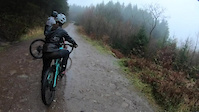
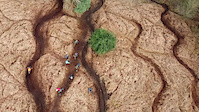
Photos of Pontypridd Mountain Bike
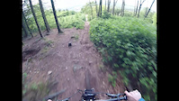
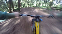
Videos of Pontypridd Mountain Bike
trail: Rossers Descent
3:38 |
456 |
Dec 13, 2020
trail: Black Gold
2:00 |
495 |
Mar 3, 2020

trail: Pallet Land
0:41 |
193 |
Jan 28, 2020
trail: Pallet Land
0:24 |
63 |
May 23, 2017

trail: Pallet Land
0:45 |
110 |
Dec 3, 2016

trail: Pallet Land
2:58 |
42 |
Mar 31, 2016
trail: Hand Built
0:53 |
521 |
Nov 2, 2015

trail: Pallet Land
2:04 |
140 |
Oct 18, 2015
Recent Trail Reports
| status | trail | date | condition | info | user |
|---|---|---|---|---|---|
| Exit Plan | May 10, 2026 @ 10:12am (Europe/London) May 10, 2026 | Dry | RadBikeBro NCTC | ||
| ThreeG | May 10, 2026 @ 10:12am (Europe/London) May 10, 2026 | Dry | RadBikeBro NCTC | ||
| Coal Dump | May 10, 2026 @ 10:12am (Europe/London) May 10, 2026 | Dry | RadBikeBro NCTC | ||
| Welsh Gold | May 10, 2026 @ 10:12am (Europe/London) May 10, 2026 | Dry | RadBikeBro NCTC | ||
| White Widow | May 10, 2026 @ 10:12am (Europe/London) May 10, 2026 | Dry | RadBikeBro NCTC | ||
| Access Road | May 10, 2026 @ 10:12am (Europe/London) May 10, 2026 | Dry | RadBikeBro NCTC | ||
| Fern Turns to Pond | May 10, 2026 @ 10:12am (Europe/London) May 10, 2026 | Dry | RadBikeBro NCTC | ||
| Log Jump | Mar 17, 2026 @ 12:33pm (Europe/London) Mar 17, 2026 | Variable | dantett | ||
| Access Road | Mar 17, 2026 @ 12:33pm (Europe/London) Mar 17, 2026 | Prevalent Mud | dantett | ||
| Charlie Horse | Mar 17, 2026 @ 12:33pm (Europe/London) Mar 17, 2026 | Variable | dantett |
Activity Feed
| username | action | type | title | date |
|---|---|---|---|---|
| trailheaderz | ridden | trail | activity #97305405 and 9 more | Jun 19, 2026 @ 3:19am Jun 19, 2026 |
| CRladine | ridden | trail | activity #96025193 | Jun 1, 2026 @ 10:02am Jun 1, 2026 |
| RadBikeBro | vote | trail | activity #94513347 and 3 more | May 11, 2026 @ 1:13pm May 11, 2026 |
| RadBikeBro | add | report | activity #94427269 and 6 more | May 10, 2026 @ 7:58am May 10, 2026 |
| xavgoesotb | comment | trail | activity #94083327 | May 5, 2026 @ 5:25am May 5, 2026 |
Recent Comments
| username | type | title | comment | date |
|---|---|---|---|---|
| trail | Mary is indeed very scary | May 5, 2026 @ 5:25am May 5, 2026 | ||
| trail | Trees down everywhere blocking fireroad! | Feb 16, 2025 @ 1:28pm Feb 16, 2025 | ||
| trail | I used this as a climb... its just a straight... | Nov 6, 2024 @ 12:46pm Nov 6, 2024 | ||
| trail | Loved it, way better than coal dump | Nov 6, 2024 @ 12:43pm Nov 6, 2024 | ||
| trail | Overgrown | Jul 14, 2024 @ 2:57am Jul 14, 2024 |
Local Badges
-

Epic Ride Climb 2k4 awarded -

Climbing 10k Badge35 awarded -

Climbing 100k Badge0 awarded -

Epic Ride Descent 2k4 awarded -

Descent 10k Badge36 awarded -

Descent 100k Badge0 awarded
Activity Type Stats
| activitytype | trails | distance | descent | descent distance | total vertical | rating | global rank | state rank | photos | reports | routes | ridelogs |
|---|---|---|---|---|---|---|---|---|---|---|---|---|
| Mountain Bike | 42 | 15 miles | 7,211 ft | 9 miles | 915 ft | #3,219 | #103 | 47 | 211 | 1 | 3,599 | |
| E-Bike | 18 | 5 miles | 2,710 ft | 3 miles | 899 ft | #4,960 | #209 | 197 | 850 | |||
| Hike | 10 | 8 miles | 600 ft | 2 miles | 915 ft | #9,027 | #273 | 192 | 49 | |||
| Trail Running | 10 | 8 miles | 600 ft | 2 miles | 915 ft | #8,286 | #252 | 192 | 222 |
Frequently Asked Questions About Pontypridd
▼
What are the best places to ride in Pontypridd?
Pontypridd has 2 areas to explore for mountain biking. The top rated areas are:
▼
What are the highest rated mountain biking trails in Pontypridd?
The highest rated mountain biking trails in Pontypridd are:
- Pallet Land (4.3/5)
- Exit Plan (4.2/5)
- Scary Mary (4.2/5)
- Bridge Track (4.1/5)
- Bottom Track (4.1/5)
▼
What is the best time of the year to ride in Pontypridd?
Based on ride log data, the most popular months to ride in Pontypridd are:
- January (13 activities)
- November (12 activities)
- May (10 activities)
▼
Where can I park to ride in Pontypridd?
Check the Pontypridd trail map for trailhead and parking information. Community members regularly update access and parking details for trails in the area.
- By gav-s
 & contributors
 - Admins: apply
- #26807 - 5,364 views
- pontypridd activity log | embed map of Pontypridd mountain bike trails |
Downloading of trail gps tracks in kml & gpx formats is enabled for Pontypridd.
You must login to download files.