close
-
Layers w
- Weather Layers
- Pro
- Pro
- Pro
- Pro
- Pro
- Pro
- More Layers
- Pro
- Pro
- Pro
- Pro
-
Upgrade to

3D
Trail Conditions
- Unknown
- Snow Groomed
- Snow Packed
- Snow Covered
- Snow Cover Partial
- Freeze/thaw Cycle
- Icy
- Prevalent Mud
- Wet
- Variable
- Ideal
- Dry
- Very Dry
Trail Flow (Ridden Direction)
Trailforks scans users ridelogs to determine the most popular direction each trail is ridden. A good flowing trail network will have most trails flowing in a single direction according to their intension.
The colour categories are based on what percentage of riders are riding a trail in its intended direction.
The colour categories are based on what percentage of riders are riding a trail in its intended direction.
- > 96%
- > 90%
- > 80%
- > 70%
- > 50%
- < 50%
- bi-directional trail
- no data
Trail Last Ridden
Trailforks scans ridelogs to determine the last time a trail was ridden.
- < 2 days
- < 1 week
- < 2 weeks
- < 1 month
- < 6 months
- > 6 months
Trail Ridden Direction
The intended direction a trail should be ridden.
- Downhill Only
- Downhill Primary
- Both Directions
- Uphill Primary
- Uphill Only
- One Direction
Contribute Details
Colors indicate trail is missing specified detail.
- Description
- Photos
- Description & Photos
- Videos
Trail Popularity ?
Trailforks scans ridelogs to determine which trails are ridden the most in the last 9 months.
Trails are compared with nearby trails in the same city region with a possible 25 colour shades.
Think of this as a heatmap, more rides = more kinetic energy = warmer colors.
- most popular
- popular
- less popular
- not popular
ATV/ORV/OHV Filter
Max Vehicle Width
inches
US Cell Coverage
Legend

Radar Time
Activity Recordings
Trailforks uses anonymized public activity data.
?
Activity Recordings
Trailforks uses anonymized public activity data.
?
Personal Heatmap
▶
Activity Types
all
/
none
▶
Options
2
Date range
month
–
Winter Trails
Warning
A routing network for winter maps does not exist. Selecting trails using the winter trails layer has been disabled.
Missing Trails
Most Popular
Least Popular
Trails are colored based on popularity. The more popular a trail is, the more red. Less popular trails trend towards green.
Jump Magnitude Heatmap
Heatmap of where riders jump on trails. Zoom in to see individual jumps, click circles to view jump details.
BC Backroad Status
![map legend]()
Service Road Atlas is a free to use, community-driven service for viewing and creating reports on the numerous back-country service roads around B.C. and Alberta.

Slope Aspect
Direction the slope faces
Trails Deemphasized
Trails are shown in grey.
Only show trails with no bike usage.
Suggested Layers
Based on selected activity type
Save the current map location and zoom level as your default home location whenever this page is loaded.
Save
No description for Poole has been added yet!
Login or register to submit one.
This region uses the Uk/Euro style trail grading system.
Activities Click to view
- Mountain Bike
9 trails
- E-Bike
4 trails
- Gravel Bike
0 trails
- Adaptive Bike
0 trails
- Winter Fat Bike
0 trails
- Hike
8 trails
- Trail Running
8 trails
Region Details
- 1
- 4
- 4
Region Status
Open as of Jun 8, 2026Stats
- Trails (view details)
- 9
- Trails Mountain Bike
- 9
- Trails E-Bike
- 4
- Trails Hike
- 8
- Trails Trail Running
- 8
- Total Distance
- 2 miles
- Total Descent
- 632 ft
- Total Vertical
- 218 ft
- Highest Trailhead
- 226 ft
- Reports
- 34
- Photos
- 42
- Ridden Counter
- 113
Popular Poole Mountain Biking Trails
• 75 ★ 0.0 • 389 ft • 0 ft • 64 •
Man made single and double dirt jumps in a line.
• 100 ★ 0.0 • 964 ft • 0 ft • 56 •
A fairly straight downhill path, with spaced out drops created by large railway sleepers laid in the ground. You can go pretty quickly, but watch out for dog walkers (visibility is good though, so shouldn't be a problem) There's a...
• 35 ★ 4.0 • 1,876 ft • 0 ft • 47 •
A simple and short dh trail for beginners to learn to ride at speed
• 90 ★ 0.0 • 1,337 ft • 0 ft • 45 •
Good fun trail with a mixture of features; a few drop-offs and some good corners. No man-made stuff like berms present. Watch out for dog walkers or cyclists coming the other way (there is an uphill Strava segment, so people do come up...
• 5 ★ 0.0 • 334 ft • 2 ft • 38 •
A short downhill section with a jump half way down. Watch out for a little jump at the bottom that's easy to miss (or hit accidentally)
• 45 ★ 4.0 • 1,540 ft • 0 ft • 37 •
Another simple trail for all types with a short steep gravelly section for the slightly more capable.
• 30 ★ 0.0 • 484 ft • 0 ft • 28 •
Down hill double track that starts off on gravel. Fast section of trail but watch out for dog walkers. The associated Strava segment isn't an exact match at the end of the trail.
Poole Mountain Bike Routes
28 miles • 1,573 ft • 0 •
Talbot Woods to the Purbecks using the Sandbanks Ferry. Banks Arms,Old Harry Rocks, 9 Barrow Down then...
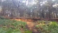
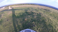
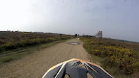
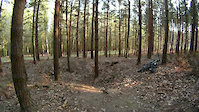
Photos of Poole Mountain Bike
Videos of Poole Mountain Bike
trail: Bombhole
0:22 |
332 |
Oct 18, 2016
trail: The steps
0:59 |
240 |
Aug 4, 2016
trail: DH Canford Heath
9:50 |
259 |
Oct 14, 2015

trail: The steps
0:42 |
140 |
Jul 20, 2013
trail: Bombhole
0:08 |
329 |
Apr 1, 2012
trail: Bombhole
0:09 |
654 |
Mar 30, 2009
trail: Bombhole
0:09 |
514 |
Mar 30, 2009

trail: The steps
0:07 |
139 |
Jun 29, 2008
Recent Trail Reports
| status | trail | date | condition | info | user |
|---|---|---|---|---|---|
| Bombhole - middle line | Jul 6, 2025 @ 5:28am Jul 6, 2025 | Dry | Ben3141592653 | ||
| DH Canford Heath | Jun 26, 2024 @ 10:28am Jun 26, 2024 | Dry | gazb1966 | ||
| Alternative DH to Canford Heath | Jun 26, 2024 @ 10:25am Jun 26, 2024 | Dry | gazb1966 | ||
| Little slog DH | Jan 16, 2022 @ 8:17am Jan 16, 2022 | Wet | Cook1e20 | ||
| Holes Bay Cycle Path | Oct 24, 2021 @ 2:16am Oct 24, 2021 | Variable | kevpuk | ||
| The steps | May 19, 2020 @ 10:11am May 19, 2020 | Dry | tonemtb | ||
| Bombhole | Apr 9, 2019 @ 5:04am Apr 9, 2019 | Variable | gordonfontaine | ||
| DH to Canford Heath | Feb 20, 2017 @ 1:49pm Feb 20, 2017 | Dry | 8R4D |
Activity Feed
| username | action | type | title | date |
|---|---|---|---|---|
| TomaszMietki | wishlist | route | activity #95303785 | May 23, 2026 @ 4:20am May 23, 2026 |
| TomaszMietki | wishlist | route | activity #95199215 | May 21, 2026 @ 1:59pm May 21, 2026 |
| YHWgeg | ridden | route | activity #90356817 | Mar 10, 2026 @ 4:26pm Mar 10, 2026 |
| lucas2355 | ridden | trail | activity #86710325 | Jan 5, 2026 @ 1:48pm Jan 5, 2026 |
| trailforks | add | video | activity #81296824 | Sep 28, 2025 @ 10:00am Sep 28, 2025 |
Activity Type Stats
| activitytype | trails | distance | descent | descent distance | total vertical | rating | global rank | state rank | photos | reports | routes | ridelogs |
|---|---|---|---|---|---|---|---|---|---|---|---|---|
| Mountain Bike | 9 | 2 miles | 633 ft | 2 miles | 217 ft | #11,649 | #445 | 42 | 34 | 2 | 3,814 | |
| E-Bike | 4 | 1 mile | 207 ft | 4,984 ft | 213 ft | #9,226 | #407 | 28 | 2 | 259 | ||
| Hike | 8 | 2 miles | 584 ft | 2 miles | 217 ft | #13,235 | #493 | 31 | 2 | 26 | ||
| Trail Running | 8 | 2 miles | 584 ft | 2 miles | 217 ft | #12,746 | #483 | 31 | 1 | 6 |
Frequently Asked Questions About Poole
▼
What are the highest rated mountain biking trails in Poole?
The highest rated mountain biking trails in Poole are:
- Alternative DH to Canford Heath (4/5)
- DH Canford Heath (4/5)
- Holes Bay Cycle Path (0/5)
- The steps (0/5)
- Little slog DH (0/5)
▼
What is the best time of the year to ride in Poole?
Based on ride log data, the most popular months to ride in Poole are:
- June (25 activities)
- August (13 activities)
- March (12 activities)
▼
Where can I park to ride in Poole?
Check the Poole trail map for trailhead and parking information. Community members regularly update access and parking details for trails in the area.
▼
What is the longest trail in Poole?
The longest trail in Poole is Holes Bay Cycle Path at 4,734 ft. View all trails sorted by distance.
- By MoALP & contributors
- Admins: wisey, MathieuC, cemoorelife, DRR
- #60867 - 1,411 views
- poole activity log | embed map of Poole mountain bike trails |
Downloading of trail gps tracks in kml & gpx formats is enabled for Poole.
You must login to download files.