close
-
Layers w
- Weather Layers
- Pro
- Pro
- Pro
- Pro
- Pro
- Pro
- More Layers
- Pro
- Pro
- Pro
- Pro
-
Upgrade to

3D
Trail Conditions
- Unknown
- Snow Groomed
- Snow Packed
- Snow Covered
- Snow Cover Partial
- Freeze/thaw Cycle
- Icy
- Prevalent Mud
- Wet
- Variable
- Ideal
- Dry
- Very Dry
Trail Flow (Ridden Direction)
Trailforks scans users ridelogs to determine the most popular direction each trail is ridden. A good flowing trail network will have most trails flowing in a single direction according to their intension.
The colour categories are based on what percentage of riders are riding a trail in its intended direction.
The colour categories are based on what percentage of riders are riding a trail in its intended direction.
- > 96%
- > 90%
- > 80%
- > 70%
- > 50%
- < 50%
- bi-directional trail
- no data
Trail Last Ridden
Trailforks scans ridelogs to determine the last time a trail was ridden.
- < 2 days
- < 1 week
- < 2 weeks
- < 1 month
- < 6 months
- > 6 months
Trail Ridden Direction
The intended direction a trail should be ridden.
- Downhill Only
- Downhill Primary
- Both Directions
- Uphill Primary
- Uphill Only
- One Direction
Contribute Details
Colors indicate trail is missing specified detail.
- Description
- Photos
- Description & Photos
- Videos
Trail Popularity ?
Trailforks scans ridelogs to determine which trails are ridden the most in the last 9 months.
Trails are compared with nearby trails in the same city region with a possible 25 colour shades.
Think of this as a heatmap, more rides = more kinetic energy = warmer colors.
- most popular
- popular
- less popular
- not popular
ATV/ORV/OHV Filter
Max Vehicle Width
inches
US Cell Coverage
Legend

Radar Time
Activity Recordings
Trailforks uses anonymized public activity data.
?
Activity Recordings
Trailforks uses anonymized public activity data.
?
Personal Heatmap
▶
Activity Types
all
/
none
▶
Options
2
Date range
month
–
Winter Trails
Warning
A routing network for winter maps does not exist. Selecting trails using the winter trails layer has been disabled.
Missing Trails
Most Popular
Least Popular
Trails are colored based on popularity. The more popular a trail is, the more red. Less popular trails trend towards green.
Jump Magnitude Heatmap
Heatmap of where riders jump on trails. Zoom in to see individual jumps, click circles to view jump details.
BC Backroad Status
![map legend]()
Service Road Atlas is a free to use, community-driven service for viewing and creating reports on the numerous back-country service roads around B.C. and Alberta.

Slope Aspect
Direction the slope faces
Trails Deemphasized
Trails are shown in grey.
Only show trails with no bike usage.
Suggested Layers
Based on selected activity type
Save the current map location and zoom level as your default home location whenever this page is loaded.
SavePortoferraio (Feraja in dialetto elbano) è un comune italiano di 11 772 abitanti della provincia di Livorno, primo comune dell'Isola d'Elba per popolazione e secondo per estensione dopo Campo nell'Elba.
source: Wikipedia
This region uses the Uk/Euro style trail grading system.
Activities Click to view
- Mountain Bike
258 trails
- E-Bike
253 trails
- Gravel Bike
8 trails
- Horse
17 trails
- Hike
221 trails
- Trail Running
215 trails
- Dirtbike/Moto
9 trails
Region Details
- 79
- 2
- 39
- 96
- 17
- 24
- 1
Stats
- Avg Trail Rating
- Trails (view details)
- 262
- Trails Mountain Bike
- 258
- Trails E-Bike
- 253
- Trails Gravel Bike
- 8
- Trails Horse
- 17
- Trails Hike
- 221
- Trails Trail Running
- 215
- Trails Dirtbike/Moto
- 9
- Trails Observed Trials
- 2
- Trails ATV/ORV/OHV
- 1
- Total Distance
- 281 miles
- Total Descent
- 84,143 ft
- Total Vertical
- 3,182 ft
- Highest Trailhead
- 3,189 ft
- Reports
- 6,845
- Photos
- 1,794
- Ridden Counter
- 12,607
Sub Regions
- Capoliveri (4)
- Isola d'elba (1)
- Lacona (13)
- Marina di Campo (42)
- Portoferraio (75)
- Elba Central Area (75)
- Rio Nell' Elba (56)
- Elba Trail Area (56)
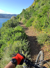
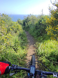
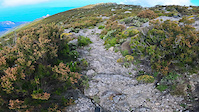
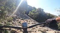
Popular Isola d'elba Mountain Biking Trails
• 100 ★ 4.5 • 4,593 ft • 0 ft • 1,034 •
This Trail is one of the best ones on Elba Island! Definitely worth a ride. Some drops, rocks, and berms included!
• 100 ★ 3.3 • 2,690 ft • 3 ft • 926 •
Popular red difficulty singletrack. This mountain bike primary trail can be used downhill primary and has a moderate overall physical rating. Trail visibility is always easy to follow. On average it takes 6 minutes to complete this trail.
• 95 ★ 3.7 • 1 mile • 181 ft • 735 •
Popular blue difficulty singletrack. This mountain bike primary trail can be used uphill primary and has a moderate overall physical rating with a 181 ft blue climb. Trail visibility is always easy to follow. On average it takes 9 minutes to complete this trail.
• 95 ★ 4.7 • 3,182 ft • 0 ft • 673 •
Highly rated popular red difficulty singletrack. This mountain bike primary trail can be used downhill only and has a moderate overall physical rating. Trail visibility is always easy to follow. On average it takes 5 minutes to complete this trail.
• 100 ★ 4.7 • 1 mile • 248 ft • 650 •
Highly rated popular blue difficulty singletrack. This mountain bike primary trail can be used one direction and has a moderate overall physical rating with a 248 ft blue climb. Trail visibility is always easy to follow. On average it takes 10 minutes to complete this trail.
• 100 ★ 3.6 • 958 ft • 113 ft • 636 •
Popular blue difficulty singletrack. This mountain bike primary trail can be used uphill primary and has a hard overall physical rating with a 113 ft blue climb. On average it takes 2 minutes to complete this trail.
• 100 ★ 4.0 • 4,088 ft • 23 ft • 633 •
Highly rated popular blue difficulty singletrack. This mountain bike primary trail can be used downhill primary and has a easy overall physical rating with a 23 ft green climb. It features berm and drop. Trail visibility is always easy to follow. On average it takes 5 minutes to complete this trail.
• 90 ★ 4.1 • 3,632 ft • 58 ft • 631 •
Highly rated popular blue difficulty singletrack. This mountain bike primary trail can be used downhill primary and has a moderate overall physical rating with a 58 ft blue climb. It features berm and roller coaster. Trail visibility is always easy to follow. On average it takes 6 minutes to complete this trail.
Isola d'elba Mountain Bike Routes
★ 3.5 • 3 miles • 67 ft • 5 • Point to Point •
Enduro 3 Lunghezza: 5,4 km Dislivello: 45 m La classica “Polveriera”: l’intramontabile discesa...
★ 4.0 • 30 miles • 5,510 ft • 17 •
Legend Cup Lunghezza: 52 km Dislivello: 1960 mt Tempo: 5,5 h Fondo: 25% asfalto, 40% strada bianca, 35%...
★ 4.0 • 14 miles • 2,240 ft • 7 •
Miniere Lunghezza: 24 km Difficoltà: medio Dislivello totale: 550 m Tempo: 2,5 h 30% asfalto, 30% strada...
★ 5.0 • 9 miles • 2,306 ft • 13 • Point to Point •
Percorso da enduro nel Bike Park Elba Ovest
★ 5.0 • 30 miles • 5,897 ft • 8 • Point to Point •
3 days trip in Isola D'elba, from Cavo to Rio Marina. All Mountain ride with nice trails and nice views on...
Photos of Isola d'elba Mountain Bike
Videos of Isola d'elba Mountain Bike
trail: PS 4 Via Della Calce
0:39 |
|
Apr 28, 2025
trail: PS 5 Oceano
0:00 |
|
Apr 28, 2025
trail: La Tavola DH
2:50 |
211 |
Jun 5, 2023
trail: Neviera Trail
0:30 |
387 |
Jun 4, 2023
trail: Neviera Trail
0:31 |
219 |
Jun 4, 2023
trail: Neviera Trail
0:29 |
|
Jun 4, 2023
trail: Colle Palombaia Trail
0:20 |
|
Apr 3, 2023
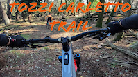
trail: Tozzicarletto
2:56 |
64 |
Dec 11, 2022
Current Trail Warnings
| status | trail | date | condition | user | info |
|---|---|---|---|---|---|
| Green Pass Bike Land Elba Ovest | Jun 7, 2026 @ 6:23am (Europe/Rome) Jun 6, 2026 | Unknown | mooglie | difficult to find the way through, lot of... | |
| Sheriff Bike Land Elba Ovest | Jun 7, 2026 @ 6:21am (Europe/Rome) Jun 6, 2026 | Unknown | mooglie | trail head almost not visible, so we did... | |
| 135 Marina di Campo | Jun 6, 2026 @ 6:37am (Europe/Rome) Jun 5, 2026 | Unknown | mooglie | overgrown |
Recent Trail Reports
Activity Feed
| username | action | type | title | date |
|---|---|---|---|---|
| thijzer | wishlist | route | activity #97571816 | Jun 22, 2026 @ 10:41am 1 day |
| thijzer | wishlist | route | activity #97570052 | Jun 22, 2026 @ 10:14am 1 day |
| thijzer | wishlist | route | activity #97564907 | Jun 22, 2026 @ 8:49am 1 day |
| tomone | wishlist | region | activity #97564251 | Jun 22, 2026 @ 8:39am 1 day |
| Francesco6WRzdA | ridden | trail | activity #97553339 and 1 more | Jun 22, 2026 @ 4:40am 1 day |
Recent Comments
| username | type | title | comment | date |
|---|---|---|---|---|
| trail | Ja | Jun 18, 2026 @ 2:09pm Jun 18, 2026 | ||
| trail | Very fun if you like stony trails. Na major... | Jun 15, 2026 @ 12:32pm Jun 15, 2026 | ||
| trail | The first part is flowy and similar to Zucca... | Jun 15, 2026 @ 2:41am Jun 15, 2026 | ||
| trail | If every black trail in Finale ligure bores... | Jun 15, 2026 @ 2:31am Jun 15, 2026 | ||
| trail | I use to climb It very often with my biobike;... | Jun 12, 2026 @ 9:56pm Jun 12, 2026 |
Local Badges
-

Epic Ride 50k57 awarded -

Completionist0 awarded -

Big Ride 30k272 awarded -

Top 10 Trails0 awarded -

10 Green Trails40 awarded -

Descent 10k Badge10 awarded
Bike & Skill Parks
| name | type | city | rating |
|---|---|---|---|
| Calendozio | skill park | Rio Nell' Elba |
Local Trail Supporters
![]()
![]()
- HOTEL BELMARE
Activity Type Stats
| activitytype | trails | distance | descent | descent distance | total vertical | rating | global rank | state rank | photos | reports | routes | ridelogs |
|---|---|---|---|---|---|---|---|---|---|---|---|---|
| Mountain Bike | 258 | 276 miles | 81,234 ft | 147 miles | 3,182 ft | #292 | #4 | 1,726 | 6,844 | 29 | 15,224 | |
| E-Bike | 253 | 272 miles | 80,965 ft | 146 miles | 3,182 ft | #184 | #21 | 75 | 6,557 | 28 | 4,801 | |
| Gravel Bike | 8 | 16 miles | 1,827 ft | 5 miles | 1,972 ft | #4,159 | #49 | 630 | 1 | 135 | ||
| Horse | 17 | 24 miles | 4,770 ft | 10 miles | 1,171 ft | 230 | ||||||
| Hike | 221 | 245 miles | 75,627 ft | 133 miles | 3,182 ft | #715 | #22 | 2 | 6,645 | 1 | 659 | |
| Trail Running | 215 | 240 miles | 74,199 ft | 131 miles | 3,182 ft | #519 | #18 | 6,607 | 1 | 392 | ||
| Dirtbike/Moto | 9 | 10 miles | 2,106 ft | 5 miles | 922 ft | 255 | 8 | |||||
| Observed Trials | 2 | 2 miles | 105 ft | 2,503 ft | 509 ft | 68 | 3 | |||||
| ATV/ORV/OHV | 1 | 3 miles | 564 ft | 1 mile | 564 ft | 165 | 1 |
Frequently Asked Questions About Isola d'elba
▼
What are the best places to ride in Isola d'elba?
Isola d'elba has 5 areas to explore for mountain biking. The top rated areas are:
▼
What are the highest rated mountain biking trails in Isola d'elba?
The highest rated mountain biking trails in Isola d'elba are:
- Zucca 2 (4.7/5)
- Cielo Alto (4.6/5)
- Case Vecchie (4.6/5)
- Il Semaforo (4.6/5)
- Zucca 1 (4.6/5)
▼
What is the longest trail in Isola d'elba?
The longest trail in Isola d'elba is I 4 Golfi at 7.1 miles. View all trails sorted by distance.
▼
What are the best & highest rated hiking trails in Isola d'elba?
The best hiking trails in Isola d'elba are: View all hiking trails sorted by popularity score.
Activities
Trails
Points of Interest
- Eremo di San Cerbone Viewpoint
- Tozza al Protano Viewpoint
- BIKE HUB Tour & Rent Information
- Residence La Pergola Lodge
- Madonna Del Monte Sight
- E-Rocks | e-Bike Moving Rents Information
- Calamandriola Viewpoint
- Pietra Murata Viewpoint
- Torre di San Giovanni Viewpoint
- Tozz'i Carletto Viewpoint
- Monte Capanne (3,225 ft)
- Monte di Cote (3,054 ft)
- La Galera (3,031 ft)
- By RiccardoCampitelli & contributors
- Admins: denitopia, marcoangeletti, cemoorelife, DanielePracchia
- #28064 - 4,139 views
- isola d'elba activity log | embed map of Isola d'elba mountain bike trails | isola d'elba mountain biking points of interest
Downloading of trail gps tracks in kml & gpx formats is enabled for Isola d'elba.
You must login to download files.