close
-
Layers w
- Weather Layers
- Pro
- Pro
- Pro
- Pro
- Pro
- Pro
- More Layers
- Pro
- Pro
- Pro
- Pro
-
Upgrade to

3D
Trail Conditions
- Unknown
- Snow Groomed
- Snow Packed
- Snow Covered
- Snow Cover Partial
- Freeze/thaw Cycle
- Icy
- Prevalent Mud
- Wet
- Variable
- Ideal
- Dry
- Very Dry
Trail Flow (Ridden Direction)
Trailforks scans users ridelogs to determine the most popular direction each trail is ridden. A good flowing trail network will have most trails flowing in a single direction according to their intension.
The colour categories are based on what percentage of riders are riding a trail in its intended direction.
The colour categories are based on what percentage of riders are riding a trail in its intended direction.
- > 96%
- > 90%
- > 80%
- > 70%
- > 50%
- < 50%
- bi-directional trail
- no data
Trail Last Ridden
Trailforks scans ridelogs to determine the last time a trail was ridden.
- < 2 days
- < 1 week
- < 2 weeks
- < 1 month
- < 6 months
- > 6 months
Trail Ridden Direction
The intended direction a trail should be ridden.
- Downhill Only
- Downhill Primary
- Both Directions
- Uphill Primary
- Uphill Only
- One Direction
Contribute Details
Colors indicate trail is missing specified detail.
- Description
- Photos
- Description & Photos
- Videos
Trail Popularity ?
Trailforks scans ridelogs to determine which trails are ridden the most in the last 9 months.
Trails are compared with nearby trails in the same city region with a possible 25 colour shades.
Think of this as a heatmap, more rides = more kinetic energy = warmer colors.
- most popular
- popular
- less popular
- not popular
ATV/ORV/OHV Filter
Max Vehicle Width
inches
US Cell Coverage
Legend

Radar Time
Activity Recordings
Trailforks uses anonymized public activity data.
?
Activity Recordings
Trailforks uses anonymized public activity data.
?
Personal Heatmap
▶
Activity Types
all
/
none
▶
Options
2
Date range
month
–
Winter Trails
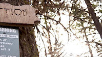
Warning
A routing network for winter maps does not exist. Selecting trails using the winter trails layer has been disabled.
Missing Trails
Most Popular
Least Popular
Trails are colored based on popularity. The more popular a trail is, the more red. Less popular trails trend towards green.
Jump Magnitude Heatmap
Heatmap of where riders jump on trails. Zoom in to see individual jumps, click circles to view jump details.
BC Backroad Status
![map legend]()
Service Road Atlas is a free to use, community-driven service for viewing and creating reports on the numerous back-country service roads around B.C. and Alberta.

Slope Aspect
Direction the slope faces
Trails Deemphasized
Trails are shown in grey.
Only show trails with no bike usage.
Suggested Layers
Based on selected activity type
Save the current map location and zoom level as your default home location whenever this page is loaded.
SaveThis region is Unsanctioned, Ride at your own Risk!
Trails Shown for Historical and Inventory Reasons.
TRAILS NOW DERELICT - Significant Damage from Logging and Motorised Recreation.
This is the second local trail area to open in springtime. At Postill, the insanus-in-the-brainius wallride is still very much worth hitting but watch for loose boards and check her out thoroughly first before hitting her. Great fun for a few quick fast rips, follow Postill Lake Road a few clicks, take a right at the Y-intersection, the drop in is a few hundred feet past the sign for Postill Lake Lodge (the sign is on the tree to right of the road) on a left hand bend, drop in to right, with a bit of a hike a bike up to start.
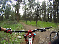
Enjoy huge portions of freeride mentalism on ‘Addiction’. New trails including ‘Inferno’ (which will include some huge new crazy tricks) and ‘Technical Difficulty’ (natural gnarly lines, low on the stunt count) should be open for business in 2008. Watch for stunts in progress, and expect to have to help cut in some new lines with your fat tire fury.
View region descriptions for other activity types
TRAILS NOW DERELICT - Significant Damage from Logging and Motorised Recreation.
This is the second local trail area to open in springtime. At Postill, the insanus-in-the-brainius wallride is still very much worth hitting but watch for loose boards and check her out thoroughly first before hitting her. Great fun for a few quick fast rips, follow Postill Lake Road a few clicks, take a right at the Y-intersection, the drop in is a few hundred feet past the sign for Postill Lake Lodge (the sign is on the tree to right of the road) on a left hand bend, drop in to right, with a bit of a hike a bike up to start.
Enjoy huge portions of freeride mentalism on ‘Addiction’. New trails including ‘Inferno’ (which will include some huge new crazy tricks) and ‘Technical Difficulty’ (natural gnarly lines, low on the stunt count) should be open for business in 2008. Watch for stunts in progress, and expect to have to help cut in some new lines with your fat tire fury.
Generic
Mountain Bike
Trails Shown for Historical and Inventory Reasons.TRAILS NOW DERELICT - Significant Damage from Logging and Motorised Recreation.
This is the second local trail area to open in springtime. At Postill, the insanus-in-the-brainius wallride is still very much worth hitting but watch for loose boards and check her out thoroughly first before hitting her. Great fun for a few quick fast rips, follow Postill Lake Road a few clicks, take a right at the Y-intersection, the drop in is a few hundred feet past the sign for Postill Lake Lodge (the sign is on the tree to right of the road) on a left hand bend, drop in to right, with a bit of a hike a bike up to start.
Enjoy huge portions of freeride mentalism on ‘Addiction’. New trails including ‘Inferno’ (which will include some huge new crazy tricks) and ‘Technical Difficulty’ (natural gnarly lines, low on the stunt count) should be open for business in 2008. Watch for stunts in progress, and expect to have to help cut in some new lines with your fat tire fury.
Dirtbike/Moto
An old mountain biking zone from the 2000s that has seen the MTB trails become derelict from old structures, logging and motorized Recreation. The area has many double track and logging roads that ATVers use. Mixed in are a few motorbike single-track. But the area doesn't not seem well maintained. ATV/ORV/OHV
An old mountain biking zone from the 2000s that has seen the MTB trails become derelict from old structures, logging and motorized Recreation. The area has many double track and logging roads that ATVers use. Mixed in are a few motorbike single-track. But the area doesn't not seem well maintained.Primary Trail Type: All-Mountain & Downhill
eBikes Allowed:
Yes
Shuttleable: YES
Land Status: Crown Land
Activities Click to view
- Mountain Bike
25 trails
- E-Bike
4 trails
- Dirtbike/Moto
33 trails
- ATV/ORV/OHV
13 trails
Region Details
- 11
- 6
- 5
- 3
Region Status
Caution as of May 31, 2025Stats
- Avg Trail Rating
- Trails (view details)
- 39
- Trails Mountain Bike
- 25
- Trails E-Bike
- 4
- Trails Hike
- 15
- Trails Trail Running
- 15
- Trails Dirtbike/Moto
- 33
- Trails ATV/ORV/OHV
- 13
- Total Distance
- 25 miles
- Total Descent
- 4,650 ft
- Total Vertical
- 2,296 ft
- Highest Trailhead
- 3,824 ft
- Reports
- 69
- Photos
- 103
- Ridden Counter
- 700
Popular Postill Mountain Biking Trails
• 5 ★ 3.8 • 1 mile • 22 ft • 43 •
Less popular black diamond difficulty singletrack. This multi-use trail. On average it takes 25 minutes to complete this trail.
Inferno Permanently Closed
• 25 ★ 3.5 • 3,352 ft • 0 ft • 11 •
Less popular double black diamond difficulty closed singletrack. This mountain bike primary trail. On average it takes 13 minutes to complete this trail.
Connector Permanently Closed
• 5 ★ 0.0 • 732 ft • 59 ft • 5 •
Less popular blue difficulty closed singletrack. This mountain bike primary trail. On average it takes 2 hours13 minutes to complete this trail.
• 5 ★ 0.0 • 1,575 ft • 0 ft • 4 •
A double black jump line with a ~30ft road gap, ladder bridges, gap jumps, drops, berms, shark fin/hip jump. This trail runs along side the legendary trail .
Rutland Girl Permanently Closed
• 5 ★ 0.0 • 2,897 ft • 15 ft • 4 •
Less popular black diamond difficulty closed singletrack. This mountain bike primary trail. On average it takes 8 minutes to complete this trail.
• 25 ★ 0.0 • 1,617 ft • 0 ft • 3 •
Fun Single-track that is hard pack and very narrow with a few jumps Does connect all the way to Postill on very old trail Worth checking out if your driving by
Tire Bitter Permanently Closed
• 5 ★ 0.0 • 3,067 ft • 16 ft • 1 •
Less popular blue difficulty closed singletrack. This mountain bike primary trail can be used downhill only. It features bridge and jump.
Photos of Postill Mountain Bike
Videos of Postill Mountain Bike
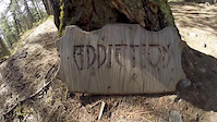
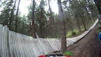
trail: Addiction
3:00 |
745 |
Apr 25, 2015
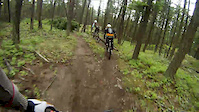
trail: Addiction
0:48 |
1516 |
May 20, 2013
trail: Addiction
0:21 |
1109 |
May 12, 2013

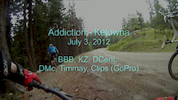
trail: Addiction
3:04 |
44102 |
Sep 13, 2012
trail: Addiction
5:01 |
204 |
Jul 26, 2012
trail: Addiction
4:39 |
351 |
Jul 25, 2012
trail: Addiction
5:17 |
143 |
Jul 25, 2012
trail: Addiction
5:34 |
187 |
Jul 25, 2012
Recent Trail Reports
| status | trail | date | condition | info | user |
|---|---|---|---|---|---|
| Access trail from Mill Creek | Nov 11, 2023 @ 9:05pm Nov 11, 2023 | Wet | CoryLlpGzo | ||
| Twisted Transistor | Oct 24, 2022 @ 2:19pm Oct 24, 2022 | Ideal | Jayc03 | ||
| Pilots License | Sep 29, 2022 @ 5:07pm Sep 29, 2022 | Ideal | Jayc03 | ||
| It Ain't Much | Sep 29, 2022 @ 5:07pm Sep 29, 2022 | Ideal | Jayc03 | ||
| Horseless Headsman | Sep 29, 2022 @ 5:07pm Sep 29, 2022 | Ideal | Jayc03 | ||
| Prickly Pears | Sep 29, 2022 @ 5:07pm Sep 29, 2022 | Ideal | Jayc03 | ||
| Technical Difficluty | Jul 6, 2018 @ 2:57pm Jul 6, 2018 | Dry | Shin-Splints |
Activity Feed
| username | action | type | title | date |
|---|---|---|---|---|
| jcorday51 | wishlist | region | activity #97078790 | Jun 15, 2026 @ 6:02pm Jun 15, 2026 |
| SmokinXC | wishlist | region | activity #97005525 | Jun 14, 2026 @ 2:36pm Jun 14, 2026 |
| trailforks | add | video | activity #92277214 and 1 more | Apr 9, 2026 @ 2:00pm Apr 9, 2026 |
| trailforks | add | video | activity #92205979 | Apr 8, 2026 @ 1:00pm Apr 8, 2026 |
| canadaka | add | photo | activity #92107039 and 2 more | Apr 7, 2026 @ 3:36am Apr 7, 2026 |
Recent Comments
| username | type | title | comment | date |
|---|---|---|---|---|
| trail | I will probably have to make a new trail... | Feb 17, 2022 @ 11:13am Feb 17, 2022 | ||
| trail | I've done some work to the very bottom part of... | Dec 10, 2021 @ 11:08am Dec 10, 2021 | ||
| trail | Hi Shred666 I am interested in helping out... | Nov 8, 2020 @ 10:04pm Nov 8, 2020 | ||
| trail | Had a bit of trouble with a guy that has a... | Sep 22, 2020 @ 9:20pm Sep 22, 2020 | ||
| trail | I have already started working towards... | Sep 22, 2020 @ 9:18pm Sep 22, 2020 |
Nearby Areas
| name | distance | ||||
|---|---|---|---|---|---|
| Lake Country Bike Park | 4 | 2 | 4.6 km | ||
| Quail Ridge Linear Park | 6 | 4.8 km | |||
| High Rim Trail to Vernon | 3 | 5 km | |||
| Jack Seaton Park | 2 | 3 | 2 | 5.4 km | |
| Black Mountain Regional Park | 4 | 5 | 7.1 km |
Activity Type Stats
| activitytype | trails | distance | descent | descent distance | total vertical | rating | global rank | state rank | photos | reports | routes | ridelogs |
|---|---|---|---|---|---|---|---|---|---|---|---|---|
| Mountain Bike | 25 | 14 miles | 2,904 ft | 5 miles | 2,297 ft | #6,429 | #272 | 100 | 69 | 414 | ||
| E-Bike | 4 | 6 miles | 23 ft | 784 ft | 2,218 ft | #7,030 | #264 | 60 | 44 | |||
| Hike | 15 | 8 miles | 2,310 ft | 4 miles | 1,808 ft | #11,205 | #419 | 60 | 68 | |||
| Trail Running | 15 | 8 miles | 2,310 ft | 4 miles | 1,808 ft | #10,338 | #379 | 60 | 19 | |||
| Dirtbike/Moto | 33 | 21 miles | 2,500 ft | 6 miles | 1,837 ft | #461 | #47 | 3 | 57 | 49 | ||
| ATV/ORV/OHV | 13 | 12 miles | 315 ft | 2 miles | 1,837 ft | #428 | #37 | 57 | 4 |
Frequently Asked Questions About Postill
▼
What are the highest rated mountain biking trails in Postill?
The highest rated mountain biking trails in Postill are:
- Addiction (3.9/5)
- Twisted Transistor (0/5)
- Narrow Flow (0/5)
- Horseless Headsman (0/5)
- Pilots License (0/5)
▼
What is the best time of the year to ride in Postill?
Based on ride log data, the most popular months to ride in Postill are:
- July (7 activities)
- May (7 activities)
- August (6 activities)
▼
Where can I park to ride in Postill?
Check the Postill trail map for trailhead and parking information. Community members regularly update access and parking details for trails in the area.
▼
What is the longest trail in Postill?
The longest trail in Postill is Addiction at 1.2 miles. View all trails sorted by distance.
Activities
Trails
- By smoke
 Simpcw & contributors
 - Admins: MTBco, MTBco, MTBco
- #5912 - 14,059 views
- postill activity log | embed map of Postill mountain bike trails | postill mountain biking points of interest
Downloading of trail gps tracks in kml & gpx formats is disabled for Postill.