close
-
Layers w
- Weather Layers
- Pro
- Pro
- Pro
- Pro
- Pro
- Pro
- More Layers
- Pro
- Pro
- Pro
- Pro
-
Upgrade to

3D
Trail Conditions
- Unknown
- Snow Groomed
- Snow Packed
- Snow Covered
- Snow Cover Partial
- Freeze/thaw Cycle
- Icy
- Prevalent Mud
- Wet
- Variable
- Ideal
- Dry
- Very Dry
Trail Flow (Ridden Direction)
Trailforks scans users ridelogs to determine the most popular direction each trail is ridden. A good flowing trail network will have most trails flowing in a single direction according to their intension.
The colour categories are based on what percentage of riders are riding a trail in its intended direction.
The colour categories are based on what percentage of riders are riding a trail in its intended direction.
- > 96%
- > 90%
- > 80%
- > 70%
- > 50%
- < 50%
- bi-directional trail
- no data
Trail Last Ridden
Trailforks scans ridelogs to determine the last time a trail was ridden.
- < 2 days
- < 1 week
- < 2 weeks
- < 1 month
- < 6 months
- > 6 months
Trail Ridden Direction
The intended direction a trail should be ridden.
- Downhill Only
- Downhill Primary
- Both Directions
- Uphill Primary
- Uphill Only
- One Direction
Contribute Details
Colors indicate trail is missing specified detail.
- Description
- Photos
- Description & Photos
- Videos
Trail Popularity ?
Trailforks scans ridelogs to determine which trails are ridden the most in the last 9 months.
Trails are compared with nearby trails in the same city region with a possible 25 colour shades.
Think of this as a heatmap, more rides = more kinetic energy = warmer colors.
- most popular
- popular
- less popular
- not popular
ATV/ORV/OHV Filter
Max Vehicle Width
inches
US Cell Coverage
Legend

Radar Time
Activity Recordings
Trailforks uses anonymized public activity data.
?
Activity Recordings
Trailforks uses anonymized public activity data.
?
Personal Heatmap
▶
Activity Types
all
/
none
▶
Options
2
Date range
month
–
Winter Trails
Warning
A routing network for winter maps does not exist. Selecting trails using the winter trails layer has been disabled.
Missing Trails
Most Popular
Least Popular
Trails are colored based on popularity. The more popular a trail is, the more red. Less popular trails trend towards green.
Jump Magnitude Heatmap
Heatmap of where riders jump on trails. Zoom in to see individual jumps, click circles to view jump details.
BC Backroad Status
![map legend]()
Service Road Atlas is a free to use, community-driven service for viewing and creating reports on the numerous back-country service roads around B.C. and Alberta.

Slope Aspect
Direction the slope faces
Trails Deemphasized
Trails are shown in grey.
Only show trails with no bike usage.
Suggested Layers
Based on selected activity type
Save the current map location and zoom level as your default home location whenever this page is loaded.
SaveThe Powers Bluff Trail System consists of:
• 4.2 miles of single-track mountain bike trail (built by Rock Solid Trail Contracting from 2022-4)
• Two gravity mountain bike trails (built by Rock Solid Trail Contracting from 2022-4)
• 3.4 miles of gravel double-track multi-use (built by Wood County Parks & Forestry from 2022-4)
• 2.3 miles of nature hiking trails
• Additional grass multi-use trails
Powers Bluff is a worn-down peak of an ancient mountain range that once covered northern Wisconsin. It is comprised almost entirely of solid quartzite and is the highest point of elevation in Wood County. 70 acres of the park is a designated State Natural Area that features a 1.5-mile nature trail. The south 80 acres of the park are listed on the National Register of Historic Places as a Native American Cultural Sensitivity Area with preserved Native American dance rings, and cemeteries. In 2012, Wood County acquired 223 acres north of the snow tubing/downhill skiing location.
Some of the winter activity highlights of the park include downhill skiing, tubing, snowboarding, cross-country skiing, snowmobiling, snowshoeing, hiking, and groomed single-track fatbike trails. Additionally, the park features a two-story stone shelter building with concessions, a fireplace, and restroom facilities.
https://www.woodcountywi.gov/Departments/Parks/PowersBluff.aspx
source: ...
Primary Trail Type: Cross-Country
Land Status: County Park
Land Manager: Wood County Parks and Forestry
 google parking directions
Links
Region Supporters & Maintainers
![]()
Rock Solid Trail Contracting
2022 - 2024Builder
Activities Click to view
- Mountain Bike
34 trails
- E-Bike
28 trails
- Hike
19 trails
- Trail Running
19 trails
- Snowmobile
4 trails
- Snowshoe
33 trails
- Downhill Ski
4 trails
- Nordic Ski
14 trails
Region Details
- 15
- 2
- 4
- 11
- 2
Region Status
Open as of Jun 21, 2026Local Trail Association
Stats
- Avg Trail Rating
- Trails (view details)
- 42
- Trails Mountain Bike
- 34
- Trails E-Bike
- 28
- Trails Gravel Bike
- 14
- Trails Adaptive Bike
- 4
- Trails Winter Fat Bike
- 19
- Trails Hike
- 19
- Trails Trail Running
- 19
- Trails Snowmobile
- 4
- Trails Snowshoe
- 33
- Trails Downhill Ski
- 4
- Trails Backcountry Ski
- 1
- Trails Nordic Ski
- 14
- Total Distance
- 13 miles
- Total Descent Distance
- 5 miles
- Total Descent
- 1,108 ft
- Total Vertical
- 259 ft
- Highest Trailhead
- 1,451 ft
- Reports
- 424
- Photos
- 27
- Ridden Counter
- 591
Popular Powers Bluff Mountain Biking Trails
• 80 ★ 4.0 • 3,182 ft • 35 ft • 40 •
Popular blue difficulty singletrack. This mountain bike primary trail can be used both directions and has a moderate overall physical rating with a 35 ft blue climb. It features drop and jump. Winter use: Groomed Smooth snow grooming. Trail visibility is sometimes hard to follow. On average it takes 3 minutes to complete this trail.
• 75 ★ 5.0 • 2,031 ft • 5 ft • 39 •
Much like it's namesake, Super Speedway, this trail has tall, tightly-banked corners. Firm, fast surface with small optional kickers on the straights. Runs downhill from south to north.
• 70 ★ 4.0 • 2,290 ft • 18 ft • 39 •
Popular blue difficulty singletrack. This mountain bike primary trail can be used both directions. Winter use: Groomed Smooth snow grooming. On average it takes 3 minutes to complete this trail.
• 100 ★ 3.0 • 3,156 ft • 58 ft • 39 •
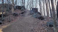
Popular blue difficulty singletrack. This mountain bike primary trail can be used both directions with a 58 ft blue climb. It features berm, jump, rock garden and wallride. Adaptive MTB rating: amtb blue. Winter use: Groomed Smooth snow grooming. Trail visibility is always easy to follow. On average it takes 5 minutes to complete this trail.
• 90 ★ 4.0 • 1,699 ft • 131 ft • 38 •
Two-way, but built as an uphill return trail for the downhill trails. Hard-packed surface, optional challenging rock gardens, low & slow berms; not groomed for winter fat-biking
• 95 ★ 4.0 • 594 ft • 0 ft • 38 •
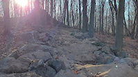
Short, hard-packed clay base downhill jump line with mandatory features including a rock garden descent, bridges, large berm, step-up, drop (with roll rock garden bypass), mini doubles, and a tabletop.
• 100 ★ 5.0 • 1,578 ft • 0 ft • 33 •
is a fast, blue-rated progression jump line with tabletop jumps, gaps, rock jumps, and large sweeping berms. Most jumps have a green-rated alternate line, making the trail accessible to more riders. The lower segment of the trail does...
• 65 ★ 5.0 • 1,923 ft • 36 ft • 32 •
Shaded, smooth trail following the field/forest boundary. Caution: water crossings are rock gardens that are slippery when wet.
Powers Bluff Mountain Bike Routes
2 miles • 95 ft • 2 •
If you'd like a smoother trail riding experience, this route might be for you. Using a combination of...
6 miles • 388 ft • 14 • Race •
Photos of Powers Bluff Mountain Bike
Videos of Powers Bluff Mountain Bike
trail: Gnarpin
0:08 |
67 |
Aug 25, 2024
trail: Gnarpin
0:19 |
38 |
Aug 25, 2024
trail: Gnarpin
0:32 |
92 |
Nov 25, 2023

trail: Power Up!
0:42 |
6 |
Jun 21, 2026 , Arpin
trail: Gnarpin
11:02 |
5 |
Jun 21, 2026 , Arpin

trail: Descension
11:02 |
6 |
Jun 21, 2026 , Arpin
trail: Pucker Factor
0:48 |
6 |
Jun 21, 2026 , Arpin

trail: Descension
0:10 |
6 |
Jun 21, 2026 , Arpin
Current Trail Warnings
| status | trail | date | condition | user | info |
|---|---|---|---|---|---|
| Winter Sports and Natural Area Parking | Jun 21, 2026 @ 9:39pm (America/Chicago) Jun 21, 2026 | Unknown | 3b3nn FOPB | Winter Fat Bike Closed to cyclists - use one of the... | |
| Pink-flagged Fatbike Trail w | Jun 21, 2026 @ 9:39pm (America/Chicago) Jun 21, 2026 | Unknown | 3b3nn FOPB | Winter Fat Bike Closed until the snow returns | |
| Blue-flagged Fatbike Trail w | Jun 21, 2026 @ 9:39pm (America/Chicago) Jun 21, 2026 | Unknown | 3b3nn FOPB | Winter Fat Bike Closed until the snow returns |
Recent Trail Reports
| status | trail | date | condition | info | user |
|---|---|---|---|---|---|
| Pucker Factor | Jun 21, 2026 @ 9:36pm (America/Chicago) Jun 21, 2026 | Variable | 3b3nn FOPB | ||
| Gnarpin | Jun 21, 2026 @ 9:36pm (America/Chicago) Jun 21, 2026 | Variable | 3b3nn FOPB | ||
| Wildflower | Jun 21, 2026 @ 9:36pm (America/Chicago) Jun 21, 2026 | Variable | 3b3nn FOPB | ||
| Slinger | Jun 21, 2026 @ 9:36pm (America/Chicago) Jun 21, 2026 | Variable | 3b3nn FOPB | ||
| Rock Bottom | Jun 21, 2026 @ 9:36pm (America/Chicago) Jun 21, 2026 | Variable | 3b3nn FOPB | ||
| Power Up! | Jun 21, 2026 @ 9:36pm (America/Chicago) Jun 21, 2026 | Variable | 3b3nn FOPB | ||
| Flysaac Newton | Jun 21, 2026 @ 9:36pm (America/Chicago) Jun 21, 2026 | Variable | 3b3nn FOPB | ||
| Fern Goblin | Jun 21, 2026 @ 9:36pm (America/Chicago) Jun 21, 2026 | Variable | 3b3nn FOPB | ||
| Doe-See-Doe | Jun 21, 2026 @ 9:36pm (America/Chicago) Jun 21, 2026 | Variable | 3b3nn FOPB | ||
| Descension | Jun 21, 2026 @ 9:36pm (America/Chicago) Jun 21, 2026 | Variable | 3b3nn FOPB |
Activity Feed
| username | action | type | title | date |
|---|---|---|---|---|
| 3b3nn | add | report | activity #97538932 and 19 more | Jun 21, 2026 @ 7:36pm Jun 21, 2026 |
| 3b3nn | add | video | activity #97538321 and 5 more | Jun 21, 2026 @ 7:18pm Jun 21, 2026 |
| 3b3nn | update | trail | activity #97365753 and 1 more | Jun 19, 2026 @ 9:35pm Jun 19, 2026 |
| 3b3nn | update | trail | activity #97348139 | Jun 19, 2026 @ 3:19pm Jun 19, 2026 |
| brooks4adventures | add | route | activity #96241506 | Jun 4, 2026 @ 11:22am Jun 4, 2026 |
Nearby Areas
| name | distance | ||||
|---|---|---|---|---|---|
| Richfield 360 County Forest | 1 | 3 km | |||
| Wildwood Park and Zoo | 1 | 9.7 km | |||
| Marshfield School Forest | 9 | 9 | 5 | 10.4 km | |
| UW Stevens Point at Marshfield Arboretum | 11.1 km | ||||
| Weber Nature Park | 11.5 km |
Local Badges
-

Completionist0 awarded
Activity Type Stats
| activitytype | trails | distance | descent | descent distance | total vertical | rating | global rank | state rank | photos | reports | routes | ridelogs |
|---|---|---|---|---|---|---|---|---|---|---|---|---|
| Mountain Bike | 34 | 10 miles | 692 ft | 3 miles | 249 ft | #6,583 | #2,499 | 26 | 424 | 3 | 139 | |
| E-Bike | 28 | 10 miles | 669 ft | 3 miles | 243 ft | #6,527 | #1,860 | 49 | 2 | |||
| Gravel Bike | 14 | 5 miles | 240 ft | 2 miles | 243 ft | |||||||
| Adaptive Bike | 4 | 1,355 ft | 16 ft | 344 ft | 16 ft | 15 | ||||||
| Winter Fat Bike | 19 | 8 miles | 282 ft | 2 miles | 243 ft | 1 | 259 | |||||
| Hike | 19 | 6 miles | 476 ft | 2 miles | 253 ft | #12,949 | #5,421 | 389 | 10 | |||
| Trail Running | 19 | 6 miles | 476 ft | 2 miles | 253 ft | #12,971 | #5,294 | 389 | 4 | |||
| Snowmobile | 4 | 2 miles | 157 ft | 1 mile | 194 ft | #286 | #124 | 388 | ||||
| Snowshoe | 33 | 11 miles | 636 ft | 3 miles | 259 ft | #971 | #473 | 418 | ||||
| Downhill Ski | 4 | 3,740 ft | 190 ft | 3,058 ft | 121 ft | #854 | #381 | 20 | ||||
| Backcountry Ski | 1 | 725 ft | 43 ft | |||||||||
| Nordic Ski | 14 | 4 miles | 121 ft | 1 mile | 243 ft | #1,745 | #866 | 389 | 1 |
Frequently Asked Questions About Powers Bluff
▼
What are the highest rated mountain biking trails in Powers Bluff?
The highest rated mountain biking trails in Powers Bluff are:
- Descension (4.1/5)
- Slinger (4.1/5)
- Creekside (4.1/5)
- Gnarpin (4.1/5)
- Pucker Factor (4.1/5)
▼
Where can I park to ride in Powers Bluff?
There are 3 parking locations listed in Powers Bluff. The most popular parking spots are:
- Winter Sports Parking Area
- Powers Bluff Overflow (Silo) Trailhead
- Winter Sports and Natural Area Parking
▼
What is the longest trail in Powers Bluff?
The longest trail in Powers Bluff is Moo Moo Meadows at 4,560 ft. View all trails sorted by distance.
▼
What are the best & highest rated hiking trails in Powers Bluff?
The best hiking trails in Powers Bluff are:
- West Potawatomi Nature Trail
- East Potawatomi Nature Trail
- Potawatomi Connector 1
- Ski-Hill to Potawatomi Trail Connector
Activities
Trails
- By 3b3nn
 FOPB & contributors
 - Admins: 3b3nn, FOPB
- #53551 - 5,722 views
- powers bluff activity log | embed map of Powers Bluff mountain bike trails | powers bluff mountain biking points of interest
Downloading of trail gps tracks in kml & gpx formats is enabled for Powers Bluff.
You must login to download files.