close
-
Layers w
- Weather Layers
- Pro
- Pro
- Pro
- Pro
- Pro
- Pro
- More Layers
- Pro
- Pro
- Pro
- Pro
-
Upgrade to

3D
Trail Conditions
- Unknown
- Snow Groomed
- Snow Packed
- Snow Covered
- Snow Cover Partial
- Freeze/thaw Cycle
- Icy
- Prevalent Mud
- Wet
- Variable
- Ideal
- Dry
- Very Dry
Trail Flow (Ridden Direction)
Trailforks scans users ridelogs to determine the most popular direction each trail is ridden. A good flowing trail network will have most trails flowing in a single direction according to their intension.
The colour categories are based on what percentage of riders are riding a trail in its intended direction.
The colour categories are based on what percentage of riders are riding a trail in its intended direction.
- > 96%
- > 90%
- > 80%
- > 70%
- > 50%
- < 50%
- bi-directional trail
- no data
Trail Last Ridden
Trailforks scans ridelogs to determine the last time a trail was ridden.
- < 2 days
- < 1 week
- < 2 weeks
- < 1 month
- < 6 months
- > 6 months
Trail Ridden Direction
The intended direction a trail should be ridden.
- Downhill Only
- Downhill Primary
- Both Directions
- Uphill Primary
- Uphill Only
- One Direction
Contribute Details
Colors indicate trail is missing specified detail.
- Description
- Photos
- Description & Photos
- Videos
Trail Popularity ?
Trailforks scans ridelogs to determine which trails are ridden the most in the last 9 months.
Trails are compared with nearby trails in the same city region with a possible 25 colour shades.
Think of this as a heatmap, more rides = more kinetic energy = warmer colors.
- most popular
- popular
- less popular
- not popular
ATV/ORV/OHV Filter
Max Vehicle Width
inches
US Cell Coverage
Legend

Radar Time
Activity Recordings
Trailforks uses anonymized public activity data.
?
Activity Recordings
Trailforks uses anonymized public activity data.
?
Personal Heatmap
▶
Activity Types
all
/
none
▶
Options
2
Date range
month
–
Winter Trails
Warning
A routing network for winter maps does not exist. Selecting trails using the winter trails layer has been disabled.
Missing Trails
Most Popular
Least Popular
Trails are colored based on popularity. The more popular a trail is, the more red. Less popular trails trend towards green.
Jump Magnitude Heatmap
Heatmap of where riders jump on trails. Zoom in to see individual jumps, click circles to view jump details.
BC Backroad Status
![map legend]()
Service Road Atlas is a free to use, community-driven service for viewing and creating reports on the numerous back-country service roads around B.C. and Alberta.

Slope Aspect
Direction the slope faces
Trails Deemphasized
Trails are shown in grey.
Only show trails with no bike usage.
Suggested Layers
Based on selected activity type
Save the current map location and zoom level as your default home location whenever this page is loaded.
Save
No description for Pownal has been added yet!
Login or register to submit one.
Activities Click to view
- Mountain Bike
65 trails
- Gravel Bike
0 trails
- Adaptive Bike
0 trails
- Winter Fat Bike
0 trails
- Hike
66 trails
- Trail Running
66 trails
- Snowmobile
4 trails
- Snowshoe
5 trails
Region Details
- 8
- 22
- 24
- 4
Region Status
Open as of Dec 16, 2025Stats
- Avg Trail Rating
- Trails (view details)
- 58
- Trails Mountain Bike
- 65
- Trails E-Bike
- 1
- Trails Horse
- 1
- Trails Hike
- 66
- Trails Trail Running
- 66
- Trails Snowmobile
- 4
- Trails Snowshoe
- 5
- Trails Backcountry Ski
- 3
- Trails Nordic Ski
- 3
- Total Distance
- 49 miles
- Total Descent
- 5,247 ft
- Total Vertical
- 411 ft
- Highest Trailhead
- 516 ft
- Reports
- 575
- Photos
- 55
- Ridden Counter
- 18,136
Sub Regions
-
Bradbury Mountain State Park
- 16
- 18
- 2
-
Tryon Quarry
- 6
- 3
- 2
Popular Pownal Mountain Biking Trails
• 100 ★ 3.9 • 4,980 ft • 3 ft • 824 •
Popular blue difficulty singletrack. This mountain bike primary trail can be used both directions and has a easy overall physical rating with a 3 ft blue climb. Trail visibility is always easy to follow. On average it takes 9 minutes to complete this trail.
• 90 ★ 3.5 • 2 miles • 102 ft • 763 •
Popular blue difficulty singletrack. This mountain bike primary trail can be used both directions and has a moderate overall physical rating with a 102 ft blue climb. On average it takes 18 minutes to complete this trail.
• 85 ★ 3.4 • 4,396 ft • 68 ft • 679 •
Popular blue difficulty singletrack. This mountain bike primary trail can be used both directions and has a easy overall physical rating with a 68 ft green climb. On average it takes 7 minutes to complete this trail.
• 90 ★ 3.7 • 1 mile • 72 ft • 656 •
Popular blue difficulty singletrack. This mountain bike primary trail can be used both directions and has a easy overall physical rating with a 72 ft green climb. On average it takes 17 minutes to complete this trail.
• 95 ★ 3.7 • 1,253 ft • 3 ft • 650 •
Popular blue difficulty singletrack. This mountain bike primary trail can be used both directions and has a easy overall physical rating with a 3 ft green climb. On average it takes 2 minutes to complete this trail.
• 80 ★ 3.8 • 3,274 ft • 25 ft • 579 •
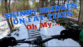
Popular blue difficulty singletrack. This mountain bike primary trail can be used both directions and has a easy overall physical rating with a 25 ft green climb. Winter use: Groomed Smooth snow grooming. Trail visibility is always easy to follow. On average it takes 5 minutes to complete this trail.
Pownal Mountain Bike Routes
★ 3.5 • 3 miles • 174 ft • 6 •
First time out at Bradbury, still learning the trails but had a blast. Looking forward to getting out more.
8 miles • 658 ft • 0 •
Links up some different trail sections in the area. Fairly hilly terrain with lots of roots. Parking lot...
• 4 miles • 183 ft • 4 •
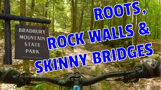
Photos of Pownal Mountain Bike
Videos of Pownal Mountain Bike
trail: Ginn
0:37 |
64 |
Feb 12, 2020
trail: Switchback
0:17 |
920 |
Jun 4, 2014
trail: Switchback
0:45 |
1162 |
May 3, 2014

trail: Fox West
11:13 |
48 |
Oct 10, 2025 , Pownal
trail: Fox East
10:16 |
44 |
Sep 26, 2025 , Pownal

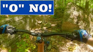
trail: "O" Trail
13:26 |
209 |
Sep 19, 2024 , Pownal
trail: "O" Trail
18:48 |
205 |
Jun 10, 2024 , Pownal
15:53 |
108 |
Mar 11, 2024
Recent Trail Reports
| status | trail | date | condition | info | user |
|---|---|---|---|---|---|
| Fern | Sep 17, 2025 @ 9:26pm (America/New_York) Sep 17, 2025 | Unknown | mra413 | ||
| Back door to home | Sep 5, 2025 @ 9:59am Sep 5, 2025 | Unknown | trailsmuggler | ||
| Happy Ending | Aug 31, 2025 @ 5:10pm Aug 31, 2025 | Dry | DaveE-Trail | ||
| Libby Rd Access | Jul 28, 2025 @ 8:50am Jul 28, 2025 | Unknown | wkunker | ||
| Northern Loop | Jun 29, 2025 @ 3:29pm Jun 29, 2025 | Ideal | Cknowlesmaine | ||
| Lanzo | Jun 29, 2025 @ 3:29pm Jun 29, 2025 | Variable | Cknowlesmaine | ||
| Ginn | Jun 29, 2025 @ 3:29pm Jun 29, 2025 | Wet | Cknowlesmaine | ||
| Snowmobile Trail | Jun 29, 2025 @ 3:29pm Jun 29, 2025 | Variable | Cknowlesmaine | ||
| Ginn Jr | Jun 29, 2025 @ 3:29pm Jun 29, 2025 | Variable | Cknowlesmaine | ||
| Link Trail | Jun 29, 2025 @ 3:29pm Jun 29, 2025 | Wet | Cknowlesmaine |
Activity Feed
| username | action | type | title | date |
|---|---|---|---|---|
| StewartUSA | wishlist | route | activity #97001824 and 1 more | Jun 14, 2026 @ 1:44pm Jun 14, 2026 |
| bjhargrave | wishlist | route | activity #96994145 and 1 more | Jun 14, 2026 @ 12:13pm Jun 14, 2026 |
| LenaAASuvO | wishlist | region | activity #96329851 | Jun 5, 2026 @ 4:47pm Jun 5, 2026 |
| romofo420 | ridden | trail | activity #96312417 | Jun 5, 2026 @ 11:53am Jun 5, 2026 |
| tmarieg3 | ridden | route | activity #95244317 | May 22, 2026 @ 8:25am May 22, 2026 |
Recent Comments
| username | type | title | comment | date |
|---|---|---|---|---|
| trail | This is a classic trail that's fun in both... | Oct 5, 2025 @ 5:49pm Oct 5, 2025 | ||
| trail | This is a classic trail that's fun in both... | Oct 5, 2025 @ 5:47pm Oct 5, 2025 | ||
| trail | It seems like it’s closed. Should be removed... | Oct 5, 2025 @ 4:46pm Oct 5, 2025 | ||
| trail | The trailhead now sports a no bike sign. Best... | May 16, 2025 @ 4:18am May 16, 2025 | ||
| trail | Rode on 9/22/24 after many years of riding... | Sep 22, 2024 @ 5:44pm Sep 22, 2024 |
Local Badges
-

10 Green Trails196 awarded -

10 Blue Trails364 awarded -

Epic Ride Climb 2k1 awarded -

Climbing 10k Badge34 awarded -

Climbing 100k Badge1 awarded -

Epic Ride Descent 2k1 awarded
Activity Type Stats
| activitytype | trails | distance | descent | descent distance | total vertical | rating | global rank | state rank | photos | reports | routes | ridelogs |
|---|---|---|---|---|---|---|---|---|---|---|---|---|
| Mountain Bike | 65 | 49 miles | 5,246 ft | 21 miles | 410 ft | #1,407 | #533 | 45 | 575 | 5 | 12,838 | |
| E-Bike | 1 | 514 | 136 | |||||||||
| Horse | 1 | 5,154 ft | 125 ft | 3,494 ft | 72 ft | 135 | 1 | |||||
| Hike | 66 | 49 miles | 5,246 ft | 21 miles | 410 ft | #4,694 | #1,655 | 577 | 561 | |||
| Trail Running | 66 | 49 miles | 5,246 ft | 21 miles | 410 ft | #4,091 | #1,244 | 577 | 290 | |||
| Snowmobile | 4 | 3 miles | 502 ft | 2 miles | 302 ft | #352 | #182 | 4 | ||||
| Snowshoe | 5 | 2 miles | 315 ft | 4,925 ft | 266 ft | #1,381 | #765 | 37 | ||||
| Backcountry Ski | 3 | 4,137 ft | 49 ft | 1,394 ft | 56 ft | 12 | ||||||
| Nordic Ski | 3 | 4,137 ft | 49 ft | 1,394 ft | 56 ft | 23 |
Frequently Asked Questions About Pownal
▼
What are the best places to ride in Pownal?
Pownal has 2 areas to explore for mountain biking. The top rated areas are:
▼
What are the highest rated mountain biking trails in Pownal?
The highest rated mountain biking trails in Pownal are:
- Fox West (4.2/5)
- Ginn (4.1/5)
- Knight Woods (4/5)
- Happy Ending (4/5)
- Boomerang (4/5)
▼
What is the best time of the year to ride in Pownal?
Based on ride log data, the most popular months to ride in Pownal are:
- September (220 activities)
- July (201 activities)
- February (181 activities)
▼
Where can I park to ride in Pownal?
There are 3 parking locations listed in Pownal. The most popular parking spots are: View all parking and trailhead locations on the map to plan your visit.
Activities
Trails
Points of Interest
- By GoRideYoBike
 & contributors
 - Admins: NEMBAEXEC, GP NEMBA
- #5713 - 5,020 views
- pownal activity log | embed map of Pownal mountain bike trails | pownal mountain biking points of interest
Downloading of trail gps tracks in kml & gpx formats is enabled for Pownal.
You must login to download files.