close
-
Layers w
- Weather Layers
- Pro
- Pro
- Pro
- Pro
- Pro
- Pro
- More Layers
- Pro
- Pro
- Pro
- Pro
-
Upgrade to

3D
Trail Conditions
- Unknown
- Snow Groomed
- Snow Packed
- Snow Covered
- Snow Cover Partial
- Freeze/thaw Cycle
- Icy
- Prevalent Mud
- Wet
- Variable
- Ideal
- Dry
- Very Dry
Trail Flow (Ridden Direction)
Trailforks scans users ridelogs to determine the most popular direction each trail is ridden. A good flowing trail network will have most trails flowing in a single direction according to their intension.
The colour categories are based on what percentage of riders are riding a trail in its intended direction.
The colour categories are based on what percentage of riders are riding a trail in its intended direction.
- > 96%
- > 90%
- > 80%
- > 70%
- > 50%
- < 50%
- bi-directional trail
- no data
Trail Last Ridden
Trailforks scans ridelogs to determine the last time a trail was ridden.
- < 2 days
- < 1 week
- < 2 weeks
- < 1 month
- < 6 months
- > 6 months
Trail Ridden Direction
The intended direction a trail should be ridden.
- Downhill Only
- Downhill Primary
- Both Directions
- Uphill Primary
- Uphill Only
- One Direction
Contribute Details
Colors indicate trail is missing specified detail.
- Description
- Photos
- Description & Photos
- Videos
Trail Popularity ?
Trailforks scans ridelogs to determine which trails are ridden the most in the last 9 months.
Trails are compared with nearby trails in the same city region with a possible 25 colour shades.
Think of this as a heatmap, more rides = more kinetic energy = warmer colors.
- most popular
- popular
- less popular
- not popular
ATV/ORV/OHV Filter
Max Vehicle Width
inches
US Cell Coverage
Legend

Radar Time
Activity Recordings
Trailforks uses anonymized public activity data.
?
Activity Recordings
Trailforks uses anonymized public activity data.
?
Personal Heatmap
▶
Activity Types
all
/
none
▶
Options
2
Date range
month
–
Winter Trails
Warning
A routing network for winter maps does not exist. Selecting trails using the winter trails layer has been disabled.
Missing Trails
Most Popular
Least Popular
Trails are colored based on popularity. The more popular a trail is, the more red. Less popular trails trend towards green.
Jump Magnitude Heatmap
Heatmap of where riders jump on trails. Zoom in to see individual jumps, click circles to view jump details.
BC Backroad Status
![map legend]()
Service Road Atlas is a free to use, community-driven service for viewing and creating reports on the numerous back-country service roads around B.C. and Alberta.

Slope Aspect
Direction the slope faces
Trails Deemphasized
Trails are shown in grey.
Only show trails with no bike usage.
Suggested Layers
Based on selected activity type
Save the current map location and zoom level as your default home location whenever this page is loaded.
Save
No description for Pragelato has been added yet!
Login or register to submit one.
This region uses the Uk/Euro style trail grading system.
Activities Click to view
- Mountain Bike
45 trails
- E-Bike
15 trails
- Adaptive Bike
0 trails
- Hike
44 trails
- Trail Running
43 trails
Region Details
- 3
- 4
- 21
Region Status
Caution as of Aug 17, 2025Stats
- Avg Trail Rating
- Trails (view details)
- 34
- Trails Mountain Bike
- 45
- Trails E-Bike
- 15
- Trails Horse
- 3
- Trails Hike
- 44
- Trails Trail Running
- 43
- Total Distance
- 45 miles
- Total Descent
- 27,695 ft
- Total Vertical
- 4,619 ft
- Highest Trailhead
- 9,143 ft
- Reports
- 45
- Photos
- 44
- Ridden Counter
- 594
Popular Pragelato Mountain Biking Trails
• 100 ★ 0.0 • 3 miles • 452 ft • 140 •
Popular green difficulty singletrack. This mountain bike primary trail can be used downhill primary and has a easy overall physical rating with a 452 ft green climb. Trail visibility is always easy to follow. On average it takes 13 minutes to complete this trail.
• 95 ★ 4.5 • 4 miles • 15 ft • 51 •
Long DH trail from Colle dell'Albergian to Laux. The first part is a great single-track with some steep sections and some loose rocks. The last part is a gravel road.
• 95 ★ 4.0 • 1 mile • 806 ft • 47 •
Climb from the Moremout hut to Colle dell'Albergian. It provides access to the long Albergian DH trail. It is a single track with some loose rocks. Not always easy to ride.
• 100 ★ 5.0 • 3,235 ft • 0 ft • 42 •
Descent from Colle del Pis to the Balsiglia Valley, first part (to the first Plateau). Easy single-track with some rocks
• 80 ★ 3.5 • 3 miles • 62 ft • 28 •
Discesa su sentiero tracciato n°328 dal colle verso il Lago Lauson, poi per ampie praterie alpine su Grand Puy. Dal centro della borgata (RALLENTARE! ATTENZIONE AI PEDONI!) si prosegue su magnifica mullatiera fino a Pragelato....
• 90 ★ 0.0 • 1 mile • 29 ft • 11 • • hike
IT-Sentiero stretto a volte esposto con alcuni passaggi tecnici e piccole salite Durante la salita, alcuni tratti vengono spinti. Attenzione agli escursionisti Espagnol-Sendero estrecho a veces expuesto con algun paso tecnico y pequenas...
• 65 ★ 4.0 • 3,409 ft • 0 ft • 8 •
Single track from Allevè to Pragelato Granges. Some loose rocks, would need some cleaning
Pragelato Mountain Bike Routes
36 miles • 7,481 ft • 0 • Loop •
This route is a modified version of the xc marathon "Assietta Epic", a very intense ride on the physical...
• 7 miles • 1,347 ft • 0 •
• 11 miles • 1,837 ft • 0 •
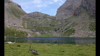
Photos of Pragelato Mountain Bike
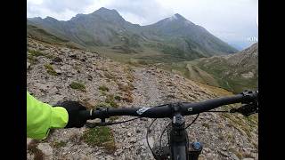
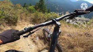
Videos of Pragelato Mountain Bike
6:56 |
4 |
May 14, 2026
6:54 |
10 |
May 14, 2026
2:48 |
21 |
Oct 23, 2025

5:12 |
139 |
Sep 21, 2022 , Pragelato

5:12 |
116 |
Sep 21, 2022 , Pragelato

5:12 |
124 |
Sep 21, 2022 , Pragelato

trail: Pattemouche - Colle del Pis
5:12 |
96 |
Sep 21, 2022 , Pragelato
Recent Trail Reports
| status | trail | date | condition | info | user |
|---|---|---|---|---|---|
| Cerogne-Pourrieres. 331 | Aug 17, 2025 @ 9:35am Aug 17, 2025 | Ideal | paco-jones | ||
| Rocca del Colle S, 378 | Aug 17, 2025 @ 9:35am Aug 17, 2025 | Ideal | paco-jones | ||
| Rocca del Colle N, 378 | Aug 17, 2025 @ 9:35am Aug 17, 2025 | Ideal | paco-jones | ||
| Colle de l'Assietta S-331 | Aug 17, 2025 @ 9:35am Aug 17, 2025 | Ideal | paco-jones | ||
| Cole Blegier-Alpe Giarasson | Aug 17, 2025 @ 9:35am Aug 17, 2025 | Unknown | paco-jones | ||
| Colle del Pis - Trampolini di Pragelato | Aug 19, 2025 @ 12:32am Aug 19, 2025 | Ideal | paco-jones | ||
| Kinka | Aug 18, 2025 @ 10:23am Aug 18, 2025 | Ideal | paco-jones | ||
| Pradamont | Jul 30, 2025 @ 4:13am Jul 30, 2025 | Unknown | oceano66 | ||
| Colle dell'Albergian - Laux DH | Jul 16, 2025 @ 11:34am Jul 16, 2025 | Ideal | beppesensation | ||
| Moremout - Colle dell'Albergian | Jul 16, 2025 @ 11:34am Jul 16, 2025 | Ideal | beppesensation |
Activity Feed
| username | action | type | title | date |
|---|---|---|---|---|
| paco-jones | add | video | activity #94678274 and 1 more | May 14, 2026 @ 3:44am May 14, 2026 |
| FrankCdU0ej | wishlist | trail | activity #93764148 | May 1, 2026 @ 2:37am May 1, 2026 |
| gabri00 | wishlist | trail | activity #90680659 | Mar 16, 2026 @ 12:51am Mar 16, 2026 |
| paco-jones | add | video | activity #82878627 | Oct 23, 2025 @ 10:31am Oct 23, 2025 |
| paco-jones | add | photo | activity #78596624 | Aug 21, 2025 @ 2:30am Aug 21, 2025 |
Local Badges
-

Epic Mountain Bike Climb 2k211 awarded -

Climbing 10k Badge15 awarded -

Mountain Biking 100k Badge0 awarded -

Epic Ride Descent 2k211 awarded -

Descent 10k Badge15 awarded -

Descent 100k Badge0 awarded
Activity Type Stats
| activitytype | trails | distance | descent | descent distance | total vertical | rating | global rank | state rank | photos | reports | routes | ridelogs |
|---|---|---|---|---|---|---|---|---|---|---|---|---|
| Mountain Bike | 45 | 45 miles | 27,694 ft | 29 miles | 4,619 ft | #4,168 | #260 | 44 | 45 | 1 | 1,310 | |
| E-Bike | 15 | 24 miles | 14,698 ft | 15 miles | 4,413 ft | #4,154 | #395 | 39 | 1 | 200 | ||
| Horse | 3 | 10 miles | 2,441 ft | 3 miles | 3,461 ft | 1 | ||||||
| Hike | 44 | 36 miles | 26,027 ft | 26 miles | 4,413 ft | #4,633 | #196 | 44 | 295 | |||
| Trail Running | 43 | 36 miles | 26,027 ft | 26 miles | 4,413 ft | #4,537 | #205 | 44 | 7 |
Frequently Asked Questions About Pragelato
▼
What are the highest rated mountain biking trails in Pragelato?
The highest rated mountain biking trails in Pragelato are:
- Colle de l'Assietta S-331 (4.1/5)
- Rocca del Colle N, 378 (4.1/5)
- Colle del Pis - Balsiglia 1 DH (4.1/5)
- Gd Puy-Soucheres-Basses (4.1/5)
- Laghi del'Albergian (4.1/5)
▼
What is the best time of the year to ride in Pragelato?
Based on ride log data, the most popular months to ride in Pragelato are:
- August (9 activities)
- June (8 activities)
- July (6 activities)
▼
Where can I park to ride in Pragelato?
There are 4 parking locations listed in Pragelato. The most popular parking spots are: View all parking and trailhead locations on the map to plan your visit.
▼
What is the longest trail in Pragelato?
The longest trail in Pragelato is Colle dell'Albergian - Laux DH at 3.5 miles. View all trails sorted by distance.
Activities
Trails
- By cheorch
 & contributors
 - Admins: silviu86, adessoomaipiu
- #9462 - 2,812 views
- pragelato activity log | embed map of Pragelato mountain bike trails | pragelato mountain biking points of interest
Downloading of trail gps tracks in kml & gpx formats is enabled for Pragelato.
You must login to download files.