close
-
Layers w
- Weather Layers
- Pro
- Pro
- Pro
- Pro
- Pro
- Pro
- More Layers
- Pro
- Pro
- Pro
- Pro
-
Upgrade to

3D
Trail Conditions
- Unknown
- Snow Groomed
- Snow Packed
- Snow Covered
- Snow Cover Partial
- Freeze/thaw Cycle
- Icy
- Prevalent Mud
- Wet
- Variable
- Ideal
- Dry
- Very Dry
Trail Flow (Ridden Direction)
Trailforks scans users ridelogs to determine the most popular direction each trail is ridden. A good flowing trail network will have most trails flowing in a single direction according to their intension.
The colour categories are based on what percentage of riders are riding a trail in its intended direction.
The colour categories are based on what percentage of riders are riding a trail in its intended direction.
- > 96%
- > 90%
- > 80%
- > 70%
- > 50%
- < 50%
- bi-directional trail
- no data
Trail Last Ridden
Trailforks scans ridelogs to determine the last time a trail was ridden.
- < 2 days
- < 1 week
- < 2 weeks
- < 1 month
- < 6 months
- > 6 months
Trail Ridden Direction
The intended direction a trail should be ridden.
- Downhill Only
- Downhill Primary
- Both Directions
- Uphill Primary
- Uphill Only
- One Direction
Contribute Details
Colors indicate trail is missing specified detail.
- Description
- Photos
- Description & Photos
- Videos
Trail Popularity ?
Trailforks scans ridelogs to determine which trails are ridden the most in the last 9 months.
Trails are compared with nearby trails in the same city region with a possible 25 colour shades.
Think of this as a heatmap, more rides = more kinetic energy = warmer colors.
- most popular
- popular
- less popular
- not popular
ATV/ORV/OHV Filter
Max Vehicle Width
inches
US Cell Coverage
Legend

Radar Time
Activity Recordings
Trailforks uses anonymized public activity data.
?
Activity Recordings
Trailforks uses anonymized public activity data.
?
Personal Heatmap
▶
Activity Types
all
/
none
▶
Options
2
Date range
month
–
Winter Trails
Warning
A routing network for winter maps does not exist. Selecting trails using the winter trails layer has been disabled.
Missing Trails
Most Popular
Least Popular
Trails are colored based on popularity. The more popular a trail is, the more red. Less popular trails trend towards green.
Jump Magnitude Heatmap
Heatmap of where riders jump on trails. Zoom in to see individual jumps, click circles to view jump details.
BC Backroad Status
![map legend]()
Service Road Atlas is a free to use, community-driven service for viewing and creating reports on the numerous back-country service roads around B.C. and Alberta.

Slope Aspect
Direction the slope faces
Trails Deemphasized
Trails are shown in grey.
Only show trails with no bike usage.
Suggested Layers
Based on selected activity type
Save the current map location and zoom level as your default home location whenever this page is loaded.
SavePredator Ridge Resort is continuously expanding and maintaining its trail network. Voted the #1 amenity by homeowners, these trails are a valuable asset to the resort.
Explore a diverse range of trails, from technical rock slabs and flowy jump lines to scenic, meandering climbs—there’s something for everyone.
Many trails are multi-use, so please practice proper trail etiquette when encountering hikers and stick to designated MTB trails.
The Predator Ridge bike trails are now open for the season Please respect all closures and detours as development continues at the resort.
Thank you, and enjoy the ride!
Primary Trail Type: Cross-Country
eBikes Allowed:
Yes
Land Status: Private Property
Activities Click to view
- Mountain Bike
47 trails
- E-Bike
44 trails
- Hike
53 trails
- Trail Running
53 trails
- Snowshoe
15 trails
Region Details
- 2
- 3
- 8
- 20
- 12
- 2
Region Status
Open as of Jun 4, 2026Stats
- Avg Trail Rating
- Trails (view details)
- 56
- Trails Mountain Bike
- 47
- Trails E-Bike
- 44
- Trails Hike
- 53
- Trails Trail Running
- 53
- Trails Observed Trials
- 1
- Trails Snowshoe
- 15
- Total Distance
- 23 miles
- Total Descent
- 4,827 ft
- Total Vertical
- 841 ft
- Highest Trailhead
- 2,558 ft
- Reports
- 1,151
- Photos
- 305
- Ridden Counter
- 31,722
Popular Predator Ridge Mountain Biking Trails
• 90 ★ 4.5 • 1,686 ft • 6 ft • 2,269 •
Short switchback trail with tight berms. Fun quick little down that can then be climbed again without much trouble. Trail will take you down to the Outlook Cabin.
• 90 ★ 4.4 • 2,290 ft • 23 ft • 1,878 •
This is a double track trail taking you from the Outlook Cabin over to Birdie lake, from there to the MTB parking lot and .
• 95 ★ 4.1 • 2 miles • 150 ft • 1,735 •
Brand new trail built by Predator Ridge in Spring of 2018. has it all, a fast flowing descent, smooth rock slabs, snappy berms, punchy climbs and views worth packing a picnic lunch. is set as a primary down trail but it you have the...
• 100 ★ 2.9 • 2 miles • 574 ft • 1,454 •
The , Blue gains elevation quickly as it takes you to the top of the trail net work. With the quick punchy climbs and a short flowy reprieves it is a great climbing trial to lap the rework.
• 100 ★ 4.2 • 2,402 ft • 108 ft • 1,443 •
This is the newest climb trail in the Predator Ridge trail net work. Once the new subdivision is complete you will be able to short cut across to the Look Out Cabin and over to the other trails on the other side of the resort. Via...
• 100 ★ 3.4 • 1,923 ft • 3 ft • 1,269 •
This is a temporary finish to the allowing access to Ellison Prov. Park.
• 95 ★ 3.0 • 446 ft • 0 ft • 934 •
Popular white difficulty paved path. This mountain bike primary trail. On average it takes minutes to complete this trail.
• 95 ★ 4.0 • 1,352 ft • 10 ft • 900 •
This is the start of , also the connector to Rock Garden Play ground A trail in it's own rights, with short rock slabs, gravity feeds and optional drops and tec rock features.
Predator Ridge Mountain Bike Routes
9 miles • 1,534 ft • 14 •
This is the NOCS Fiver Downcountry route for the advanced level. Lots of ups and downs on this ride....
8 miles • 1,270 ft • 7 •
This is the official route for the NOCS 2023 Downcountry fiver. Expect some rock fun descents down , a...
2 miles • 163 ft • 1 •
This is the first social ride of 2023! brought to you by Predator ridge. Enjoy some of the beautiful views...
7 miles • 1,358 ft • 14 •
The first Social Ride of 2023 is brought to you by Predator Ridge! The new trails are up and ready for you...
5 miles • 922 ft • 7 •
This is the first social ride of 2023 brought to you by predator ridge! with a classic loop back to the...
1 mile • 71 ft • 1 •
NOCS 2023 Predator Downhill Mantle/Predator
Photos of Predator Ridge Mountain Bike
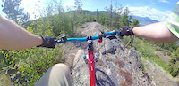
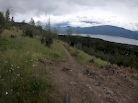
Videos of Predator Ridge Mountain Bike
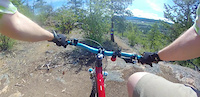
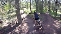
trail: The Mantle
0:35 |
301 |
May 31, 2021
trail: The Mantle
0:45 |
208 |
May 31, 2021
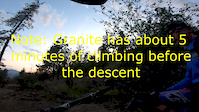
trail: Granite
13:30 |
1156 |
Aug 1, 2019
trail: Ellison Connector
0:07 |
158 |
Jun 8, 2019
trail: Ellison Connector
0:10 |
777 |
May 23, 2016

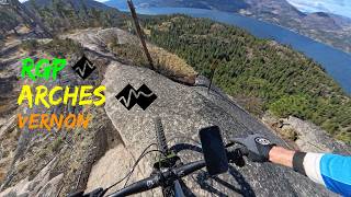
trail: Arches
8:44 |
106 |
Mar 12, 2026 , Vernon
8:44 |
47 |
Mar 12, 2026 , Vernon

trail: Rock Garden Playground
8:44 |
26 |
Mar 12, 2026 , Vernon
Recent Trail Reports
| status | trail | date | condition | info | user |
|---|---|---|---|---|---|
| Rock Garden Play Ground Lower | Jun 4, 2026 @ 11:17am (America/Vancouver) Jun 4, 2026 | Ideal | st107 | ||
| Finish Granite Trail | May 28, 2026 @ 7:22am (America/Creston) May 28, 2026 | Ideal | bb1957 | ||
| Rift Connect | May 28, 2026 @ 7:22am (America/Creston) May 28, 2026 | Ideal | bb1957 | ||
| Rift loop | May 28, 2026 @ 7:22am (America/Creston) May 28, 2026 | Ideal | bb1957 | ||
| Lower Rift | May 28, 2026 @ 7:22am (America/Creston) May 28, 2026 | Dry | bb1957 | ||
| Arches | May 27, 2026 @ 1:39pm (America/Creston) May 27, 2026 | Dry | Swordfern | ||
| RGP | May 27, 2026 @ 1:39pm (America/Creston) May 27, 2026 | Ideal | Swordfern | ||
| RGP Main blk line | May 27, 2026 @ 1:39pm (America/Creston) May 27, 2026 | Ideal | Swordfern | ||
| RGP | May 27, 2026 @ 1:39pm (America/Creston) May 27, 2026 | Ideal | Swordfern | ||
| Rock Garden Playground | May 27, 2026 @ 1:39pm (America/Creston) May 27, 2026 | Ideal | Swordfern |
Activity Feed
| username | action | type | title | date |
|---|---|---|---|---|
| dldewar | ridden | trail | activity #96887374 | Jun 13, 2026 @ 9:28am Jun 13, 2026 |
| enjoiashely | wishlist | route | activity #96825577 | Jun 12, 2026 @ 1:38pm Jun 12, 2026 |
| st107 | add | report | activity #96241242 | Jun 4, 2026 @ 11:17am Jun 4, 2026 |
| DrayAck | ridden | trail | activity #96229626 | Jun 4, 2026 @ 8:27am Jun 4, 2026 |
| lindae63 | wishlist | trail | activity #95904599 | May 30, 2026 @ 6:59pm May 30, 2026 |
Recent Comments
| username | type | title | comment | date |
|---|---|---|---|---|
| trail | I strongly disagree with the negative feedback... | Aug 6, 2025 @ 10:40am Aug 6, 2025 | ||
| trail | Anyone know what this trail is like after a... | Aug 2, 2025 @ 8:28am Aug 2, 2025 | ||
| trail | Gonna echo others. The connector is easier to... | Jul 15, 2025 @ 1:02pm Jul 15, 2025 | ||
| report | Rode it today and the water is really deep,... | May 6, 2025 @ 7:02pm May 6, 2025 | ||
| report | Yeah that was a wierd puddle. We just walked... | Apr 25, 2025 @ 11:15pm Apr 25, 2025 |
Nearby Areas
| name | distance | ||||
|---|---|---|---|---|---|
| Ellison Provincial Park | 11 | 12 | 3 | 2 km | |
| Kalamalka Lake | 17 | 44 | 6 | 3 | 6.2 km |
| Becker Bike Park | 4 | 6 | 7.4 km | ||
| Spion Kop | 8 | 7 | 2 | 1 | 7.5 km |
| King Eddie Plateau | 3 | 40 | 6 | 8.1 km |
Local Badges
-

Completionist1 awarded
Activity Type Stats
| activitytype | trails | distance | descent | descent distance | total vertical | rating | global rank | state rank | photos | reports | routes | ridelogs |
|---|---|---|---|---|---|---|---|---|---|---|---|---|
| Mountain Bike | 47 | 20 miles | 4,209 ft | 10 miles | 833 ft | #791 | #67 | 253 | 1,132 | 9 | 5,231 | |
| E-Bike | 44 | 18 miles | 3,780 ft | 9 miles | 833 ft | #2,752 | #91 | 3 | 1,096 | 423 | ||
| Hike | 53 | 22 miles | 4,327 ft | 10 miles | 840 ft | #495 | #35 | 47 | 1,100 | 837 | ||
| Trail Running | 53 | 22 miles | 4,327 ft | 10 miles | 840 ft | #4,656 | #158 | 1 | 1,100 | 377 | ||
| Observed Trials | 1 | 217 ft | 10 ft | 197 ft | 10 ft | 1 | ||||||
| Snowshoe | 15 | 5 miles | 892 ft | 2 miles | 522 ft | #666 | #59 | 310 | 14 |
Frequently Asked Questions About Predator Ridge
▼
What are the highest rated mountain biking trails in Predator Ridge?
The highest rated mountain biking trails in Predator Ridge are:
- The Mantle (4.4/5)
- Arches (4.4/5)
- Rock Garden Playground, Main Line (4.4/5)
- RGP (4.2/5)
- Out Look Cabin Trail (4.2/5)
▼
What is the best time of the year to ride in Predator Ridge?
Based on ride log data, the most popular months to ride in Predator Ridge are:
- July (112 activities)
- June (103 activities)
- May (69 activities)
▼
Where can I park to ride in Predator Ridge?
Check the Predator Ridge trail map for trailhead and parking information. Community members regularly update access and parking details for trails in the area.
▼
What is the longest trail in Predator Ridge?
The longest trail in Predator Ridge is Granite at 3.4 km. View all trails sorted by distance.
Activities
Trails
Points of Interest
- By canadaka
 Trailforks & contributors
 - Admins: roanz, steed, marco93, NOCS, smoke, dialedrides, predator ridge
- #18859 - 31,890 views
- predator ridge activity log | embed map of Predator Ridge mountain bike trails | predator ridge mountain biking points of interest
Downloading of trail gps tracks in kml & gpx formats is enabled for Predator Ridge.
You must login to download files.