close
-
Layers w
- Weather Layers
- Pro
- Pro
- Pro
- Pro
- Pro
- Pro
- More Layers
- Pro
- Pro
- Pro
- Pro
-
Upgrade to

3D
Trail Conditions
- Unknown
- Snow Groomed
- Snow Packed
- Snow Covered
- Snow Cover Partial
- Freeze/thaw Cycle
- Icy
- Prevalent Mud
- Wet
- Variable
- Ideal
- Dry
- Very Dry
Trail Flow (Ridden Direction)
Trailforks scans users ridelogs to determine the most popular direction each trail is ridden. A good flowing trail network will have most trails flowing in a single direction according to their intension.
The colour categories are based on what percentage of riders are riding a trail in its intended direction.
The colour categories are based on what percentage of riders are riding a trail in its intended direction.
- > 96%
- > 90%
- > 80%
- > 70%
- > 50%
- < 50%
- bi-directional trail
- no data
Trail Last Ridden
Trailforks scans ridelogs to determine the last time a trail was ridden.
- < 2 days
- < 1 week
- < 2 weeks
- < 1 month
- < 6 months
- > 6 months
Trail Ridden Direction
The intended direction a trail should be ridden.
- Downhill Only
- Downhill Primary
- Both Directions
- Uphill Primary
- Uphill Only
- One Direction
Contribute Details
Colors indicate trail is missing specified detail.
- Description
- Photos
- Description & Photos
- Videos
Trail Popularity ?
Trailforks scans ridelogs to determine which trails are ridden the most in the last 9 months.
Trails are compared with nearby trails in the same city region with a possible 25 colour shades.
Think of this as a heatmap, more rides = more kinetic energy = warmer colors.
- most popular
- popular
- less popular
- not popular
ATV/ORV/OHV Filter
Max Vehicle Width
inches
US Cell Coverage
Legend

Radar Time
Activity Recordings
Trailforks uses anonymized public activity data.
?
Activity Recordings
Trailforks uses anonymized public activity data.
?
Personal Heatmap
▶
Activity Types
all
/
none
▶
Options
2
Date range
month
–
Winter Trails
Warning
A routing network for winter maps does not exist. Selecting trails using the winter trails layer has been disabled.
Missing Trails
Most Popular
Least Popular
Trails are colored based on popularity. The more popular a trail is, the more red. Less popular trails trend towards green.
Jump Magnitude Heatmap
Heatmap of where riders jump on trails. Zoom in to see individual jumps, click circles to view jump details.
BC Backroad Status
![map legend]()
Service Road Atlas is a free to use, community-driven service for viewing and creating reports on the numerous back-country service roads around B.C. and Alberta.

Slope Aspect
Direction the slope faces
Trails Deemphasized
Trails are shown in grey.
Only show trails with no bike usage.
Suggested Layers
Based on selected activity type
Save the current map location and zoom level as your default home location whenever this page is loaded.
Save
No description for Prievidza has been added yet!
Login or register to submit one.
Activities Click to view
- Mountain Bike
72 trails
- E-Bike
10 trails
- Gravel Bike
0 trails
- Adaptive Bike
0 trails
- Winter Fat Bike
0 trails
- Hike
59 trails
- Trail Running
60 trails
Region Details
- 27
- 9
- 29
- 6
Region Status
Open as of Jun 6, 2026Local Trail Association
Stats
- Avg Trail Rating
- Trails (view details)
- 72
- Trails Mountain Bike
- 72
- Trails E-Bike
- 10
- Trails Horse
- 1
- Trails Hike
- 59
- Trails Trail Running
- 60
- Trails Backcountry Ski
- 1
- Total Distance
- 100 miles
- Total Descent
- 33,157 ft
- Total Vertical
- 3,624 ft
- Highest Trailhead
- 4,380 ft
- Reports
- 490
- Photos
- 93
- Ridden Counter
- 3,144
Sub Regions
-
Bojnicko-Dubnické cyklotrasy
- 3
- 4
- 1
-
Sekaninské enduro traily
- 2
- 3
- 2
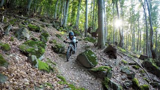
Popular Prievidza Mountain Biking Trails
• 85 ★ 4.8 • 2 miles • 329 ft • 171 •
Highly rated popular green difficulty family friendly singletrack. This mountain bike primary trail can be used downhill primary and has a easy overall physical rating with a 329 ft blue climb. It features rock face. On average it takes 33 minutes to complete this trail.
• 95 ★ 4.8 • 3,278 ft • 0 ft • 164 •
Highly rated popular black diamond difficulty singletrack. This mountain bike primary trail can be used downhill only and has a hard overall physical rating. Trail visibility is always easy to follow. On average it takes 7 minutes to complete this trail.
• 95 ★ 4.4 • 2,694 ft • 0 ft • 143 •
Highly rated popular blue difficulty singletrack. This mountain bike primary trail can be used downhill only and has a moderate overall physical rating. On average it takes 6 minutes to complete this trail.
• 95 ★ 4.7 • 3,504 ft • 13 ft • 132 •
Popular blue difficulty singletrack. This mountain bike primary trail can be used downhill only and has a easy overall physical rating with a 13 ft green climb. Trail visibility is always easy to follow. On average it takes 9 minutes to complete this trail.
• 100 ★ 4.2 • 4,006 ft • 0 ft • 130 •
Popular blue difficulty singletrack. This mountain bike primary trail can be used downhill only and has a moderate overall physical rating with a 0 ft green climb. Trail visibility is always easy to follow. On average it takes 14 minutes to complete this trail.
• 5 ★ 5.0 • 3,724 ft • 0 ft • 85 •
Highly rated less popular green difficulty singletrack. This mountain bike primary trail can be used downhill only and has a easy overall physical rating. It features berm, jump and pump track. On average it takes 8 minutes to complete this trail.
• 5 ★ 5.0 • 3,882 ft • 10 ft • 55 •
Less popular blue difficulty singletrack. This mountain bike primary trail can be used downhill only and has a moderate overall physical rating. It features drop and rock garden. On average it takes 15 minutes to complete this trail.
• 5 ★ 5.0 • 3,980 ft • 0 ft • 53 •
Less popular blue difficulty singletrack. This mountain bike primary trail can be used downhill primary and has a moderate overall physical rating. It features jump and ladder bridge. On average it takes 5 minutes to complete this trail.
Prievidza Mountain Bike Routes
7 miles • 2,353 ft • 4 • Loop • Race •
Small enduro race that took place in Sekaniny on August 26th, 2017
★ 5.0 • 6 miles • 1,570 ft • 6 • Loop • Race •
Short enduro race that took place in Velka Lehotka, near Prievidza on 2 Septemeber 2017
9 miles • 1,899 ft • 5 • Loop • Race •
Trat tretieho kola Hornonitrianskej enduro serie v Bojniciach. 28.9.2019
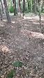
Photos of Prievidza Mountain Bike
Videos of Prievidza Mountain Bike
trail: EPS Trail
0:10 |
44 |
Sep 18, 2022
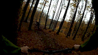
trail: Gilethov spodok
0:29 |
254 |
Nov 1, 2018
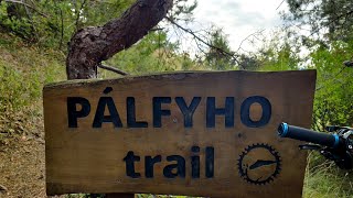
trail: Pálfyho trail
13:49 |
194 |
Nov 11, 2023 , Prievidza

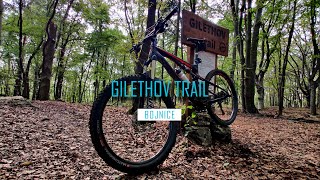
trail: Gilethov spodok
11:30 |
282 |
Jun 4, 2023 , Prievidza
trail: Gilethov vrch
11:30 |
284 |
Jun 4, 2023 , Prievidza
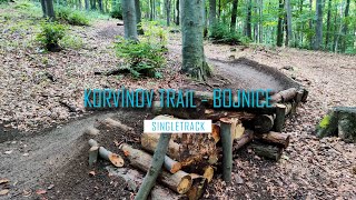
trail: Korvínov trail vrch
8:08 |
237 |
May 20, 2023 , Prievidza
trail: Hasičák
0:43 |
327 |
Aug 13, 2020 , Prievidza
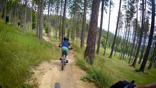
trail: Turzov Flow
3:11 |
531 |
Jul 24, 2020 , Prievidza
Recent Trail Reports
| status | trail | date | condition | info | user |
|---|---|---|---|---|---|
| Vtáčnik | Jun 7, 2026 @ 7:12am (Europe/Bratislava) Jun 6, 2026 | Ideal | jurosik | ||
| Rúbany vrch | Jun 7, 2026 @ 7:12am (Europe/Bratislava) Jun 6, 2026 | Ideal | jurosik | ||
| Gilethov spodok | Dec 27, 2025 @ 11:55am (Europe/Bratislava) Dec 27, 2025 | Variable | RichiG | ||
| Gilethov vrch | Dec 27, 2025 @ 11:55am (Europe/Bratislava) Dec 27, 2025 | Variable | RichiG | ||
| Palfy prepojovak | Dec 27, 2025 @ 11:55am (Europe/Bratislava) Dec 27, 2025 | Variable | RichiG | ||
| Bohatka access II | Sep 28, 2025 @ 11:43am (Europe/Bratislava) Sep 28, 2025 | Ideal | kocnere | ||
| Šútovske sedlo | Aug 17, 2025 @ 11:02am Aug 17, 2025 | Dry | kocnere | ||
| Pálfyho záver | Jun 14, 2025 @ 3:15pm Jun 14, 2025 | Dry | kocnere | ||
| Bohatka access | Jun 14, 2025 @ 3:15pm Jun 14, 2025 | Dry | kocnere | ||
| Šutovske access road | Jun 13, 2025 @ 3:48pm Jun 13, 2025 | Dry | kocnere |
Activity Feed
| username | action | type | title | date |
|---|---|---|---|---|
| jurosik | add | report | activity #96528011 and 1 more | Jun 8, 2026 @ 3:04am Jun 8, 2026 |
| jxxw | update | trail | activity #95023243 | May 18, 2026 @ 11:34pm May 18, 2026 |
| MiShreds | ridden | trail | activity #93765037 | May 1, 2026 @ 2:58am May 1, 2026 |
| shimon001 | vote | trail | activity #93064801 | Apr 21, 2026 @ 12:23am Apr 21, 2026 |
| Tomas89eDSj | wishlist | route | activity #91197368 | Mar 24, 2026 @ 6:03am Mar 24, 2026 |
Recent Comments
| username | type | title | comment | date |
|---|---|---|---|---|
| trail | Za mna Giletov trail asi najlepsi v tejto... | Jun 26, 2025 @ 11:39pm Jun 26, 2025 | ||
| trail | Za mna zábavný trail, na začiatku dvojaky,... | Jun 26, 2025 @ 11:34pm Jun 26, 2025 | ||
| trail | Zaciatok dosť slapania, potom už fajn. V... | Jun 26, 2025 @ 11:29pm Jun 26, 2025 | ||
| trail | Neprejazdné…konáre, lístie…značky som... | Aug 6, 2022 @ 6:10am Aug 6, 2022 | ||
| trail | fakt dost strme a strkovite, brzdy musia byt v... | Jul 4, 2021 @ 1:15pm Jul 4, 2021 |
Local Badges
-

10 Blue Trails41 awarded -

Epic Ride Climb 2k107 awarded -

Climbing 10k Badge41 awarded -

Climbing 100k Badge7 awarded -

Epic Ride Descent 2k115 awarded -

Descent 10k Badge41 awarded
Bike & Skill Parks
| name | type | city | rating |
|---|---|---|---|
| Pumptrack Nováky | skill park | Prievidza |
Activity Type Stats
| activitytype | trails | distance | descent | descent distance | total vertical | rating | global rank | state rank | photos | reports | routes | ridelogs |
|---|---|---|---|---|---|---|---|---|---|---|---|---|
| Mountain Bike | 72 | 100 miles | 33,156 ft | 50 miles | 3,625 ft | #995 | #10 | 93 | 490 | 4 | 6,399 | |
| E-Bike | 10 | 13 miles | 2,736 ft | 4 miles | 1,857 ft | #1,403 | #17 | 408 | 1,699 | |||
| Horse | 1 | 1 mile | 10 ft | 338 ft | 364 ft | 61 | ||||||
| Hike | 59 | 91 miles | 28,632 ft | 43 miles | 3,579 ft | #1,114 | #13 | 468 | 387 | |||
| Trail Running | 60 | 93 miles | 29,091 ft | 44 miles | 3,579 ft | #800 | #9 | 472 | 54 | |||
| Backcountry Ski | 1 | 35 |
Frequently Asked Questions About Prievidza
▼
What are the best places to ride in Prievidza?
Prievidza has 2 areas to explore for mountain biking. The top rated areas are:
▼
What are the highest rated mountain biking trails in Prievidza?
The highest rated mountain biking trails in Prievidza are:
- Pálfyho trail (4.6/5)
- Turzov Flow (4.5/5)
- Gilethov spodok (4.4/5)
- Partizán (4.4/5)
- Jarabá vrch (4.3/5)
▼
What is the best time of the year to ride in Prievidza?
Based on ride log data, the most popular months to ride in Prievidza are:
- July (26 activities)
- August (18 activities)
- October (13 activities)
▼
Where can I park to ride in Prievidza?
There are 3 parking locations listed in Prievidza. The most popular parking spots are: View all parking and trailhead locations on the map to plan your visit.
Activities
Trails
Points of Interest
- By jxxw
 TRAILFORKS & contributors
 - Admins: apply
- #15892 - 6,021 views
- prievidza activity log | embed map of Prievidza mountain bike trails | prievidza mountain biking points of interest
Downloading of trail gps tracks in kml & gpx formats is enabled for Prievidza.
You must login to download files.