close
-
Layers w
- Weather Layers
- Pro
- Pro
- Pro
- Pro
- Pro
- Pro
- More Layers
- Pro
- Pro
- Pro
- Pro
-
Upgrade to

3D
Trail Conditions
- Unknown
- Snow Groomed
- Snow Packed
- Snow Covered
- Snow Cover Partial
- Freeze/thaw Cycle
- Icy
- Prevalent Mud
- Wet
- Variable
- Ideal
- Dry
- Very Dry
Trail Flow (Ridden Direction)
Trailforks scans users ridelogs to determine the most popular direction each trail is ridden. A good flowing trail network will have most trails flowing in a single direction according to their intension.
The colour categories are based on what percentage of riders are riding a trail in its intended direction.
The colour categories are based on what percentage of riders are riding a trail in its intended direction.
- > 96%
- > 90%
- > 80%
- > 70%
- > 50%
- < 50%
- bi-directional trail
- no data
Trail Last Ridden
Trailforks scans ridelogs to determine the last time a trail was ridden.
- < 2 days
- < 1 week
- < 2 weeks
- < 1 month
- < 6 months
- > 6 months
Trail Ridden Direction
The intended direction a trail should be ridden.
- Downhill Only
- Downhill Primary
- Both Directions
- Uphill Primary
- Uphill Only
- One Direction
Contribute Details
Colors indicate trail is missing specified detail.
- Description
- Photos
- Description & Photos
- Videos
Trail Popularity ?
Trailforks scans ridelogs to determine which trails are ridden the most in the last 9 months.
Trails are compared with nearby trails in the same city region with a possible 25 colour shades.
Think of this as a heatmap, more rides = more kinetic energy = warmer colors.
- most popular
- popular
- less popular
- not popular
ATV/ORV/OHV Filter
Max Vehicle Width
inches
US Cell Coverage
Legend

Radar Time
Activity Recordings
Trailforks uses anonymized public activity data.
?
Activity Recordings
Trailforks uses anonymized public activity data.
?
Personal Heatmap
▶
Activity Types
all
/
none
▶
Options
2
Date range
month
–
Winter Trails
Warning
A routing network for winter maps does not exist. Selecting trails using the winter trails layer has been disabled.
Missing Trails
Most Popular
Least Popular
Trails are colored based on popularity. The more popular a trail is, the more red. Less popular trails trend towards green.
Jump Magnitude Heatmap
Heatmap of where riders jump on trails. Zoom in to see individual jumps, click circles to view jump details.
BC Backroad Status
![map legend]()
Service Road Atlas is a free to use, community-driven service for viewing and creating reports on the numerous back-country service roads around B.C. and Alberta.

Slope Aspect
Direction the slope faces
Trails Deemphasized
Trails are shown in grey.
Only show trails with no bike usage.
Suggested Layers
Based on selected activity type
Save the current map location and zoom level as your default home location whenever this page is loaded.
SavePopular Trail Networks
view all areas »
No description for Prince George has been added yet!
Login or register to submit one.
Activities Click to view
- Mountain Bike
331 trails
- E-Bike
110 trails
- Gravel Bike
0 trails
- Adaptive Bike
1 trails
- Winter Fat Bike
0 trails
- Horse
22 trails
- Hike
359 trails
- Trail Running
345 trails
- Dirtbike/Moto
20 trails
- ATV/ORV/OHV
4 trails
- Snowshoe
52 trails
- Downhill Ski
51 trails
- Nordic Ski
106 trails
Region Details
- 32
- 8
- 98
- 129
- 58
- 4
Region Status
Caution as of 13 hoursStats
- Avg Trail Rating
- Trails (view details)
- 507
- Trails Mountain Bike
- 334
- Trails E-Bike
- 110
- Trails Adaptive Bike
- 1
- Trails Horse
- 22
- Trails Hike
- 359
- Trails Trail Running
- 345
- Trails Dirtbike/Moto
- 20
- Trails ATV/ORV/OHV
- 4
- Trails Snowmobile
- 1
- Trails Snowshoe
- 52
- Trails Downhill Ski
- 51
- Trails Backcountry Ski
- 3
- Trails Nordic Ski
- 106
- Total Distance
- 391 miles
- Total Descent
- 95,776 ft
- Total Vertical
- 4,844 ft
- Highest Trailhead
- 6,672 ft
- Reports
- 5,388
- Photos
- 1,465
- Ridden Counter
- 55,843
Articles
Profile
May 4, 2024 from pinkbike.com
http://www.pinkbike.com/u/tirefunk/blog/something-new-in-northern-bc.html
Tabor Mountain, BC's Newest Bike Park - Video
Aug 10, 2016 from pinkbike.com
Here's a little preview of Tabor Mountain Bike Park, BC's newest bike park, just 20 minutes from Prince George and with trails for everyone, Tabor...

Exploring Northern British Columbia By Bike & Train
Aug 5, 2020 from pinkbike.com
A dream trip to some of British Columbia's lesser-known, but still world-class, ride locations.
Sub Regions
-
A.M.H.T Recreation Area
-
Buckhorn
-
Cranbrook Hill
- 9
- 2
- 1
- 1
-
Greenway/Forests for the World
- 5
- 38
- 40
- 7
-
Otway
- 7
- 19
- 13
-
Pidherny Recreation Site
- 19
- 45
- 19
- 1
-
Tabor Mountain Recreation Trails
- 8
- 4
-
The Swedes
-
University Hill
- 1
- 8
- 12
- 7
Popular Prince George Mountain Biking Trails
• 100 ★ 4.7 • 2,756 ft • 0 ft • 934 •
starts off flat with optional skinnies then rolls into a flowy section then gets steep where you can find the Black Garage Door Drop. You can then tie together some rooty drops into a couple of beautiful gaps, or roll through them.
• 100 ★ 4.2 • 4,321 ft • 40 ft • 791 •
A machine built trail designed and built by Jay Hoots in fall of 2017. A good alternative to climbing Ten dollar. Lots of berms to keep it fun. More fun down than up but can be ridden both ways.
• 100 ★ 4.6 • 2,021 ft • 171 ft • 753 •
Continuation of . Easy climb to the top trails.
• 100 ★ 4.6 • 2,251 ft • 108 ft • 720 •
Another Hagen Classic. Easy gradual climb that links the lower Pidherny trails to the middle & upper trails. From the bottom, Combine this track with , 5th avenue and Honey shuttle for the best climb to the top!
• 100 ★ 4.6 • 4,705 ft • 94 ft • 710 •
Rebuilt in 2021 from the original Cook brothers trail from 25 years previous The new line is full of flow and Berms Access from about 1/4 of the way down
• 70 ★ 2.8 • 312 ft • 0 ft • 708 •
A smooth singletrack trail connecting the lower carpark and skills park.
Prince George Mountain Bike Routes
Check Out the New Digs Featured
★ 5.0 • 3 miles • 516 ft • 6 • Loop •
Discover the new trails located on Tabor Mountain with this short and sweet loop. Better yet, see how fast...
4 miles • 510 ft • 7 • Loop •
Trail forks keeps freezing on IPhone trying to add to ridelog
★ 1.0 • 6 miles • 705 ft • 13 • Loop •
In celebration of PG Gals n Gears, we have created our first PG Gals n Gears Virtual Wild Ride for you to...
5 miles • 873 ft • 10 •
Strava segment for PGCC May virtual race. #covidcycling
Photos of Prince George Mountain Bike
Videos of Prince George Mountain Bike
trail: Old Cranbrook DH
0:37 |
122 |
Mar 10, 2022
trail: Dixie
2:55 |
126 |
Mar 1, 2021
trail: Ditch Pig
0:07 |
104 |
Oct 24, 2020

trail: Otter Alley
0:19 |
2318 |
Sep 13, 2020
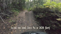
trail: Ditch Pig
2:26 |
188 |
Sep 1, 2020
trail: Upper Access Trail
0:07 |
100 |
Aug 16, 2020
trail: New England Clam Chowder
3:48 |
189 |
Nov 26, 2019

trail: Cutbanks Descent
0:56 |
248 |
Nov 3, 2019
Current Trail Warnings
| status | trail | date | condition | user | info |
|---|---|---|---|---|---|
| Devil's Club | Jun 20, 2026 @ 10:49am (America/Vancouver) Jun 20, 2026 | Unknown | dufflayer ACT | Closed due to trail mecanized maintenance. | |
| Rigamaroll | Jun 20, 2026 @ 10:45am (America/Vancouver) Jun 20, 2026 | Wet | dufflayer ACT | ||
| Ridge Run | Jun 20, 2026 @ 10:45am (America/Vancouver) Jun 20, 2026 | Wet | dufflayer ACT |
Recent Trail Reports
| status | trail | date | condition | info | user |
|---|---|---|---|---|---|
| The Kitchen Sink | Jun 28, 2026 @ 10:12pm (America/Vancouver) 13 hours | Variable | RapidElastic | ||
| Spin Cycle | Jun 28, 2026 @ 4:28pm (America/Vancouver) 19 hours | Ideal | RapidElastic | ||
| Lazy Susan | Jun 28, 2026 @ 4:27pm (America/Vancouver) 19 hours | Variable | RapidElastic | ||
| Troll Lake Trail | Jun 22, 2026 @ 10:03am (America/Los_Angeles) Jun 22, 2026 | Unknown | trailforks Trailforks | ||
| Pack It Out | Jun 22, 2026 @ 10:03am (America/Los_Angeles) Jun 22, 2026 | Unknown | trailforks Trailforks | ||
| Pack It In | Jun 22, 2026 @ 10:03am (America/Los_Angeles) Jun 22, 2026 | Unknown | trailforks Trailforks | ||
| Less is More | Jun 22, 2026 @ 10:03am (America/Los_Angeles) Jun 22, 2026 | Unknown | trailforks Trailforks | ||
| Edgewater | Jun 22, 2026 @ 10:03am (America/Los_Angeles) Jun 22, 2026 | Unknown | trailforks Trailforks | ||
| Dirt Jump Loop | Jun 22, 2026 @ 10:03am (America/Los_Angeles) Jun 22, 2026 | Unknown | trailforks Trailforks | ||
| 64 Caddy | Jun 22, 2026 @ 10:03am (America/Vancouver) Jun 22, 2026 | Unknown | trailforks Trailforks |
Activity Feed
| username | action | type | title | date |
|---|---|---|---|---|
| RapidElastic | add | report | activity #98045032 | Jun 28, 2026 @ 10:12pm 13 hours |
| CalibratedGrip | wishlist | trail | activity #98044113 and 2 more | Jun 28, 2026 @ 9:31pm 14 hours |
| RapidElastic | add | report | activity #98032927 and 1 more | Jun 28, 2026 @ 4:27pm 19 hours |
| RapidElastic | add | report | activity #98013209 | Jun 28, 2026 @ 12:06pm 23 hours |
| SophieAJsSuCzc | ridden | trail | activity #97958430 | Jun 27, 2026 @ 8:17pm 2 days |
Recent Comments
| username | type | title | comment | date |
|---|---|---|---|---|
| report | I don’t know mumj | Jun 27, 2026 @ 11:32am 2 days | ||
| trail | Best ridden West to East West end is loose... | Jun 14, 2026 @ 3:09pm Jun 14, 2026 | ||
| trail | Entropy is a masterclass in reading terrain.... | Jun 1, 2026 @ 8:41am Jun 1, 2026 | ||
| report | 1 tree down and a couple of soft spots. | Apr 29, 2026 @ 3:26pm Apr 29, 2026 | ||
| trail | The south end of Mr. Slate wear pebbles... | Feb 21, 2026 @ 11:00am Feb 21, 2026 |
Local Badges
-

Tabor Champ109 awarded -

Big Ride 30k2,397 awarded -

Descent 100k Badge19 awarded -

Epic Ride 50k949 awarded -

Top 10 Trails42 awarded -

Completionist0 awarded
Bike & Skill Parks
| name | type | city | rating |
|---|---|---|---|
| Duchess Park Pump Track | skill park | Prince George | |
| Pidherny Skill Park | skill park | Prince George | |
| Pidherny pump track | skill park | Prince George | |
| Tabor Mountain Dirt Jumps | skill park | Prince George |
Local Mountain Biking Directory
-
Caledonia Nordic Ski Club
![Caledonia Nordic Ski Club]()
-
Association of Caledonia Trailbuilders
![Association of Caledonia Trailbuilders]()
-
Prince George Cycling ClubTrail Association
![Prince George Cycling Club]()
-
Ruckus Skis Boards And BikesBike Shop
![Ruckus Skis Boards And Bikes]()
-
Players Bench Sports & Evolve BikeBike Shop
-
Koops Bike ShopBike Shop
Activity Type Stats
| activitytype | trails | distance | descent | descent distance | total vertical | rating | global rank | state rank | photos | reports | routes | ridelogs |
|---|---|---|---|---|---|---|---|---|---|---|---|---|
| Mountain Bike | 331 | 249 miles | 43,924 ft | 111 miles | 4,747 ft | #155 | #21 | 1,353 | 5,369 | 46 | 53,828 | |
| E-Bike | 110 | 100 miles | 16,496 ft | 46 miles | 2,169 ft | #829 | #39 | 4,135 | 9 | 1,863 | ||
| Adaptive Bike | 1 | #143 | #100 | 46 | 1 | |||||||
| Horse | 22 | 27 miles | 2,028 ft | 8 miles | 1,624 ft | #580 | #25 | 1,549 | 26 | |||
| Hike | 359 | 316 miles | 56,125 ft | 138 miles | 4,843 ft | #235 | #19 | 83 | 5,352 | 3 | 5,674 | |
| Trail Running | 345 | 282 miles | 49,931 ft | 127 miles | 4,843 ft | #193 | #16 | 24 | 5,342 | 8 | 8,319 | |
| Dirtbike/Moto | 20 | 13 miles | 1,004 ft | 4 miles | 653 ft | #394 | #38 | 1 | 1,538 | 98 | ||
| ATV/ORV/OHV | 4 | 2 miles | 387 ft | 1 mile | 295 ft | #243 | #24 | 1,537 | 284 | |||
| Snowmobile | 1 | 3 miles | 30 ft | 2,690 ft | 85 ft | 43 | 6 | |||||
| Snowshoe | 52 | 58 miles | 12,421 ft | 27 miles | 4,078 ft | #90 | #13 | 483 | 2 | 385 | ||
| Downhill Ski | 51 | 30 miles | 31,417 ft | 29 miles | 1,995 ft | #235 | #16 | 33 | 151 | |||
| Backcountry Ski | 3 | 13 miles | 4,816 ft | 7 miles | 4,078 ft | 14 | 282 | |||||
| Nordic Ski | 106 | 46 miles | 5,236 ft | 16 miles | 1,627 ft | #56 | #10 | 335 | 8,417 |
Frequently Asked Questions About Prince George
▼
What are the best places to ride in Prince George?
Prince George has 20 areas to explore for mountain biking. The top rated areas are:
▼
What are the highest rated mountain biking trails in Prince George?
The highest rated mountain biking trails in Prince George are:
- New England Clam Chowder (4.7/5)
- Heavy Nettle (4.6/5)
- Dimeslot (4.5/5)
- Entropy (4.5/5)
- Daydream (4.4/5)
▼
What is the best time of the year to ride in Prince George?
Based on ride log data, the most popular months to ride in Prince George are:
- July (1,058 activities)
- June (770 activities)
- August (660 activities)
▼
Where can I park to ride in Prince George?
There are 37 parking locations listed in Prince George. The most popular parking spots are: View all parking and trailhead locations on the map to plan your visit.
Activities
Trails
Points of Interest
- Longworth Fire Lookout Tower Sight
- Muster Point 4 Information
- Muster Point 3 Information
- Muster Point 5 Information
- Muster Point 8 Information
- Up and Over TTF
- Chump Change Overpass TTF
- Caledonia Nordic Ski Center Lodge
- Trail Junction - Daydream/Edgewater Other
- Muster Point 7 Information
- Mount Cochran (2,422 m)
- Mount Cushman (2,354 m)
- Clear Mountain (2,156 m)
- By brenthillier
 NSMBA TRAILFORKS & contributors
 - Admins: BCBR, TrailsBC, BCORMA, DSBC, wheelmaniac3, bcpunk, PGCC, forestuser, free-riders, Mostlyharmless80
- #3403 - 53,494 views
- prince george activity log | embed map of Prince George mountain bike trails | prince george mountain biking points of interest polygons
Downloading of trail gps tracks in kml & gpx formats is enabled for Prince George.
You must login to download files.