close
-
Layers w
- Weather Layers
- Pro
- Pro
- Pro
- Pro
- Pro
- Pro
- More Layers
- Pro
- Pro
- Pro
- Pro
-
Upgrade to

3D
Trail Conditions
- Unknown
- Snow Groomed
- Snow Packed
- Snow Covered
- Snow Cover Partial
- Freeze/thaw Cycle
- Icy
- Prevalent Mud
- Wet
- Variable
- Ideal
- Dry
- Very Dry
Trail Flow (Ridden Direction)
Trailforks scans users ridelogs to determine the most popular direction each trail is ridden. A good flowing trail network will have most trails flowing in a single direction according to their intension.
The colour categories are based on what percentage of riders are riding a trail in its intended direction.
The colour categories are based on what percentage of riders are riding a trail in its intended direction.
- > 96%
- > 90%
- > 80%
- > 70%
- > 50%
- < 50%
- bi-directional trail
- no data
Trail Last Ridden
Trailforks scans ridelogs to determine the last time a trail was ridden.
- < 2 days
- < 1 week
- < 2 weeks
- < 1 month
- < 6 months
- > 6 months
Trail Ridden Direction
The intended direction a trail should be ridden.
- Downhill Only
- Downhill Primary
- Both Directions
- Uphill Primary
- Uphill Only
- One Direction
Contribute Details
Colors indicate trail is missing specified detail.
- Description
- Photos
- Description & Photos
- Videos
Trail Popularity ?
Trailforks scans ridelogs to determine which trails are ridden the most in the last 9 months.
Trails are compared with nearby trails in the same city region with a possible 25 colour shades.
Think of this as a heatmap, more rides = more kinetic energy = warmer colors.
- most popular
- popular
- less popular
- not popular
ATV/ORV/OHV Filter
Max Vehicle Width
inches
US Cell Coverage
Legend

Radar Time
Activity Recordings
Trailforks uses anonymized public activity data.
?
Activity Recordings
Trailforks uses anonymized public activity data.
?
Personal Heatmap
▶
Activity Types
all
/
none
▶
Options
2
Date range
month
–
Winter Trails
Warning
A routing network for winter maps does not exist. Selecting trails using the winter trails layer has been disabled.
Missing Trails
Most Popular
Least Popular
Trails are colored based on popularity. The more popular a trail is, the more red. Less popular trails trend towards green.
Jump Magnitude Heatmap
Heatmap of where riders jump on trails. Zoom in to see individual jumps, click circles to view jump details.
BC Backroad Status
![map legend]()
Service Road Atlas is a free to use, community-driven service for viewing and creating reports on the numerous back-country service roads around B.C. and Alberta.

Slope Aspect
Direction the slope faces
Trails Deemphasized
Trails are shown in grey.
Only show trails with no bike usage.
Suggested Layers
Based on selected activity type
Save the current map location and zoom level as your default home location whenever this page is loaded.
SavePark founded in 2018 from land donated by John Deere. The park was the original proving grounds developed for John Deere Dubuque Works and is now becoming a mountain biking destination. The park has 6.5 miles of dirt surface singletrack and 2 miles of grass trail. Grass trail names pay homage to the equipment tested at the site. Dirt surface trail names refer to testing procedures conducted by the John Deere product verification team.
Primary Trail Type: Cross-Country
eBikes Allowed:
Yes
Land Status: Regional Recreation Area
Land Manager: Dubuque County Conservation Board
 google parking directions
 Access Info:
Parking lot off of W John Deere
Activities Click to view
- Mountain Bike
18 trails
- E-Bike
18 trails
- Hike
13 trails
- Trail Running
13 trails
- Snowshoe
6 trails
- Nordic Ski
6 trails
Region Details
- 1
- 6
- 7
- 2
- 2
Region Status
Caution as of Jun 24, 2026Stats
- Avg Trail Rating
- Trails (view details)
- 18
- Trails Mountain Bike
- 18
- Trails E-Bike
- 18
- Trails Hike
- 13
- Trails Trail Running
- 13
- Trails Snowshoe
- 6
- Trails Nordic Ski
- 6
- Total Distance
- 8 miles
- Total Descent Distance
- 3 miles
- Total Descent
- 984 ft
- Total Vertical
- 205 ft
- Highest Trailhead
- 840 ft
- Reports
- 10,218
- Photos
- 36
- Ridden Counter
- 3,758
Popular Proving Grounds Mountain Biking Trails
• 90 ★ 4.7 • 1 mile • 156 ft • 227 •
Highly rated popular blue difficulty singletrack. This multi-use trail can be used both directions. On average it takes 9 minutes to complete this trail.
• 65 ★ 3.0 • 2,254 ft • 16 ft • 218 •
Moderately popular green difficulty wilderness trail. This multi-use trail can be used both directions and has a easy overall physical rating with a 16 ft green climb. Trail visibility is always easy to follow. On average it takes 5 minutes to complete this trail.
• 70 ★ 4.6 • 2,100 ft • 3 ft • 217 •
Popular black diamond difficulty singletrack. This mountain bike primary trail can be used one direction. It features berm, drop and jump. On average it takes 3 minutes to complete this trail.
• 85 ★ 3.0 • 453 ft • 0 ft • 213 •
Popular green difficulty wilderness trail. This multi-use trail can be used both directions. On average it takes minutes to complete this trail.
• 95 ★ 4.6 • 1,762 ft • 22 ft • 208 •
Popular blue difficulty singletrack. This mountain bike primary trail can be used one direction. It features berm and jump. Trail visibility is always easy to follow. On average it takes 3 minutes to complete this trail.
Proving Grounds Mountain Bike Routes
★ 5.0 • 8 miles • 857 ft • 23 •
Good way to run all the fun and gnarly parts of Proving Grounds
5 miles • 479 ft • 12 •
Proposed option for routing race without SRW or D&C
6 miles • 669 ft • 17 •
Proposal for IMBCS Race. Route does not cross over itself
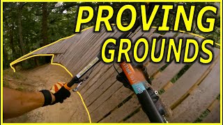
Photos of Proving Grounds Mountain Bike
Videos of Proving Grounds Mountain Bike
youtuber
![Proving Grounds | Dubuque, Iowa]()

9:22 |
214 |
Mar 31, 2024
youtuber
![Proving Grounds | Dubuque, Iowa]()
9:22 |
152 |
Mar 31, 2024
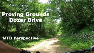
trail: Dozer Drive
0:43 |
206 |
Jun 26, 2023 , Dubuque
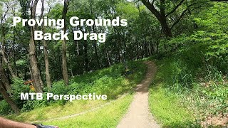
3:22 |
147 |
Jun 26, 2023

17:19 |
212 |
Sep 9, 2022
Recent Trail Reports
Activity Feed
| username | action | type | title | date |
|---|---|---|---|---|
| chipkm | add | report | activity #97724876 and 18 more | Jun 24, 2026 @ 2:38pm Jun 24, 2026 |
| chipkm | add | report | activity #97599885 and 18 more | Jun 22, 2026 @ 7:29pm Jun 22, 2026 |
| chipkm | add | report | activity #97558092 | Jun 22, 2026 @ 6:43am Jun 22, 2026 |
| chipkm | add | report | activity #97524198 and 18 more | Jun 21, 2026 @ 3:10pm Jun 21, 2026 |
| chipkm | add | report | activity #97385120 and 18 more | Jun 20, 2026 @ 5:40am Jun 20, 2026 |
Recent Comments
| username | type | title | comment | date |
|---|---|---|---|---|
| trail | Now this is a trail! Sessioned this trail to... | Jun 20, 2023 @ 11:49am Jun 20, 2023 | ||
| trail | Contains one of my most favorite wall rides ever | Sep 5, 2021 @ 4:33pm Sep 5, 2021 | ||
| trail | Super fun trail, some of the step downs can be... | Sep 5, 2021 @ 4:32pm Sep 5, 2021 | ||
| report | Does anyone know if these trails are ok to... | Aug 11, 2021 @ 11:54am Aug 11, 2021 | ||
| trail | I could ride this forever | Aug 7, 2020 @ 6:09pm Aug 7, 2020 |
Nearby Areas
| name | distance | ||||
|---|---|---|---|---|---|
| Cloie Creek | 3 | 2 | 4.3 km | ||
| FDR Mountain Bike Park | 2 | 14 | 4 | 6 km | |
| Heritage Trail | 8.6 km | ||||
| Interstate Power Preserve (IPP) | 2 | 2 | 1 | 10.8 km | |
| Hirsch Farm | 6 | 6 | 4 | 12.3 km |
Bike & Skill Parks
| name | type | city | rating |
|---|---|---|---|
| Daniel's Den | skill park | Dubuque |
Activity Type Stats
| activitytype | trails | distance | descent | descent distance | total vertical | rating | global rank | state rank | photos | reports | routes | ridelogs |
|---|---|---|---|---|---|---|---|---|---|---|---|---|
| Mountain Bike | 18 | 8 miles | 984 ft | 3 miles | 203 ft | #2,617 | #913 | 36 | 10,218 | 4 | 2,748 | |
| E-Bike | 18 | 8 miles | 984 ft | 3 miles | 203 ft | #5,671 | #1,575 | 8,332 | 31 | |||
| Hike | 13 | 7 miles | 656 ft | 2 miles | 203 ft | #11,327 | #4,556 | 10,207 | 74 | |||
| Trail Running | 13 | 7 miles | 656 ft | 2 miles | 203 ft | #10,493 | #3,923 | 10,207 | 6 | |||
| Snowshoe | 6 | 2 miles | 154 ft | 3,228 ft | 187 ft | #1,061 | #526 | 10,170 | 6 | |||
| Nordic Ski | 6 | 2 miles | 154 ft | 3,228 ft | 187 ft | #1,099 | #479 | 10,170 |
Frequently Asked Questions About Proving Grounds
▼
What are the highest rated mountain biking trails in Proving Grounds?
The highest rated mountain biking trails in Proving Grounds are:
- Hot Start (4.4/5)
- Ride Control (4.3/5)
- Back Drag (4.3/5)
- Rap Out (4.3/5)
- Rimpull (4.3/5)
▼
What is the best time of the year to ride in Proving Grounds?
Based on ride log data, the most popular months to ride in Proving Grounds are:
- July (27 activities)
- August (18 activities)
- September (14 activities)
▼
Where can I park to ride in Proving Grounds?
There are 1 parking locations listed in Proving Grounds. The most popular parking spots are:
▼
What is the longest trail in Proving Grounds?
The longest trail in Proving Grounds is Ride Control at 1.2 miles. View all trails sorted by distance.
Activities
Trails
Points of Interest
- By FroDaddyDBQ
 TMBR Monitor TMBR & contributors
 - Admins: TMBR Monitor, TMBR, TMBR Monitor, TMBR
- #28241 - 19,636 views
- proving grounds activity log | embed map of Proving Grounds mountain bike trails | proving grounds mountain biking points of interest
Downloading of trail gps tracks in kml & gpx formats is enabled for Proving Grounds.
You must login to download files.