close
-
Layers w
- Weather Layers
- Pro
- Pro
- Pro
- Pro
- Pro
- Pro
- More Layers
- Pro
- Pro
- Pro
- Pro
-
Upgrade to

3D
Trail Conditions
- Unknown
- Snow Groomed
- Snow Packed
- Snow Covered
- Snow Cover Partial
- Freeze/thaw Cycle
- Icy
- Prevalent Mud
- Wet
- Variable
- Ideal
- Dry
- Very Dry
Trail Flow (Ridden Direction)
Trailforks scans users ridelogs to determine the most popular direction each trail is ridden. A good flowing trail network will have most trails flowing in a single direction according to their intension.
The colour categories are based on what percentage of riders are riding a trail in its intended direction.
The colour categories are based on what percentage of riders are riding a trail in its intended direction.
- > 96%
- > 90%
- > 80%
- > 70%
- > 50%
- < 50%
- bi-directional trail
- no data
Trail Last Ridden
Trailforks scans ridelogs to determine the last time a trail was ridden.
- < 2 days
- < 1 week
- < 2 weeks
- < 1 month
- < 6 months
- > 6 months
Trail Ridden Direction
The intended direction a trail should be ridden.
- Downhill Only
- Downhill Primary
- Both Directions
- Uphill Primary
- Uphill Only
- One Direction
Contribute Details
Colors indicate trail is missing specified detail.
- Description
- Photos
- Description & Photos
- Videos
Trail Popularity ?
Trailforks scans ridelogs to determine which trails are ridden the most in the last 9 months.
Trails are compared with nearby trails in the same city region with a possible 25 colour shades.
Think of this as a heatmap, more rides = more kinetic energy = warmer colors.
- most popular
- popular
- less popular
- not popular
ATV/ORV/OHV Filter
Max Vehicle Width
inches
US Cell Coverage
Legend

Radar Time
Activity Recordings
Trailforks uses anonymized public activity data.
?
Activity Recordings
Trailforks uses anonymized public activity data.
?
Personal Heatmap
▶
Activity Types
all
/
none
▶
Options
2
Date range
month
–
Winter Trails
Warning
A routing network for winter maps does not exist. Selecting trails using the winter trails layer has been disabled.
Missing Trails
Most Popular
Least Popular
Trails are colored based on popularity. The more popular a trail is, the more red. Less popular trails trend towards green.
Jump Magnitude Heatmap
Heatmap of where riders jump on trails. Zoom in to see individual jumps, click circles to view jump details.
BC Backroad Status
![map legend]()
Service Road Atlas is a free to use, community-driven service for viewing and creating reports on the numerous back-country service roads around B.C. and Alberta.

Slope Aspect
Direction the slope faces
Trails Deemphasized
Trails are shown in grey.
Only show trails with no bike usage.
Suggested Layers
Based on selected activity type
Save the current map location and zoom level as your default home location whenever this page is loaded.
SaveThis region is Unsanctioned, Ride at your own Risk!
Short natural forest single tracks, downhill sections, crazy jumps and drops built in.
Primary Trail Type: All-Mountain & Downhill
Land Status: Community Forest
 google parking directions
 Access Info:
Google - Puddletown Forest MTB Parking, Unnamed Road, Dorchester, Puddletown
This region uses the Uk/Euro style trail grading system.
Activities Click to view
- Mountain Bike
32 trails
- E-Bike
12 trails
- Hike
23 trails
- Trail Running
24 trails
Region Details
- 10
- 2
- 19
- 1
Region Status
Open as of Jan 25, 2026Stats
- Avg Trail Rating
- Trails (view details)
- 32
- Trails Mountain Bike
- 32
- Trails E-Bike
- 12
- Trails Hike
- 23
- Trails Trail Running
- 24
- Total Distance
- 7 miles
- Total Descent
- 1,965 ft
- Total Vertical
- 233 ft
- Highest Trailhead
- 435 ft
- Reports
- 272
- Photos
- 243
- Ridden Counter
- 4,492
Popular Puddletown Forest Mountain Biking Trails
• 100 ★ 4.5 • 551 ft • 0 ft • 215 •
Popular blue difficulty singletrack. This mountain bike primary trail can be used both directions. It features berm and drop. On average it takes 2 minutes to complete this trail.
• 100 ★ 4.0 • 984 ft • 0 ft • 212 •
Popular blue difficulty singletrack. This mountain bike primary trail can be used downhill only and has a moderate overall physical rating. It features berm, jump and gap jump. On average it takes 1 minutes to complete this trail.
• 95 ★ 4.4 • 909 ft • 0 ft • 203 •
Highly rated popular blue difficulty singletrack. This mountain bike primary trail can be used downhill primary. It features berm, jump and gap jump. Trail visibility is always easy to follow. On average it takes 1 minutes to complete this trail.
• 85 ★ 3.7 • 1,533 ft • 0 ft • 177 •
Popular blue difficulty singletrack. This mountain bike primary trail can be used downhill primary. It features berm and jump. On average it takes 2 minutes to complete this trail.
• 20 ★ 0.0 • 1,381 ft • 0 ft • 157 •
Less popular blue difficulty singletrack. This mountain bike primary trail can be used downhill primary. It features berm and jump. On average it takes 5 minutes to complete this trail.
• 65 ★ 3.0 • 776 ft • 0 ft • 155 •
Moderately popular blue difficulty singletrack. This mountain bike primary trail can be used downhill primary. It features berm and jump. On average it takes 1 minutes to complete this trail.
• 95 ★ 1.0 • 911 ft • 0 ft • 150 •
Same start point as but head right... A few nice jumps and a couple of Bigger drops... I would grade it as red but I only have blue or black and I don't think it is a black.
• 50 ★ 4.4 • 1,085 ft • 1 ft • 149 •
Moderately popular blue difficulty singletrack. This mountain bike primary trail can be used downhill primary. On average it takes 1 minutes to complete this trail.
Puddletown Forest Mountain Bike Routes
★ 3.0 • 12 miles • 1,507 ft • 20 • Loop •
Note: many of the TF trails are closed or lost due to logging activity (May 2021), so some adoptation /...
12 miles • 1,883 ft • 29 • Loop •
All except 4 or 5 outliers of the Trailforks listed puddletown forest trails in one continuous loop...
3,806 ft • 96 ft • 2 • Point to Point •
A amateur trail with a few bends and bumps. Not very steep but can be quite fast at points. Quite busy at...
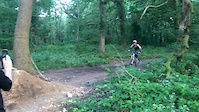
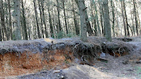
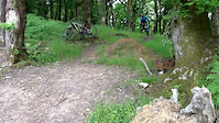
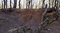
Photos of Puddletown Forest Mountain Bike
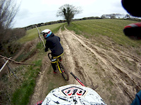
Videos of Puddletown Forest Mountain Bike

trail: Jungle Run
2:47 |
202 |
Nov 22, 2020

trail: B Line
2:05 |
791 |
May 26, 2015
trail: Bombhole
0:12 |
1070 |
Jun 20, 2014

trail: Bombhole
7:53 |
317 |
Jun 13, 2014
trail: Bombhole
0:21 |
333 |
Mar 17, 2014
trail: Bombhole
0:04 |
229 |
Jun 29, 2013
trail: Bombhole
0:11 |
393 |
Apr 28, 2013
trail: B Line
0:51 |
500 |
Mar 1, 2013
Recent Trail Reports
| status | trail | date | condition | info | user |
|---|---|---|---|---|---|
| Sandy Biff | Jan 25, 2026 @ 4:39pm (Europe/London) Jan 25, 2026 | Variable | joeg885 | ||
| Tight and Twisty | Nov 23, 2025 @ 5:05pm (Europe/London) Nov 23, 2025 | Wet | joeg885 | ||
| Dual course 2.0 | Nov 23, 2025 @ 5:03pm (Europe/London) Nov 23, 2025 | Variable | joeg885 | ||
| Bambi's Gooch | Apr 2, 2024 @ 2:43am Apr 2, 2024 | Wet | E6y62 | ||
| Pixiedust Jumps | Apr 2, 2024 @ 2:43am Apr 2, 2024 | Variable | E6y62 | ||
| Climb S | Apr 2, 2024 @ 2:43am Apr 2, 2024 | Variable | E6y62 | ||
| B Line | Apr 2, 2024 @ 2:43am Apr 2, 2024 | Variable | E6y62 | ||
| Ace of Spades | Apr 2, 2024 @ 2:43am Apr 2, 2024 | Wet | E6y62 | ||
| Pinocchio's Trousers | Apr 2, 2024 @ 2:43am Apr 2, 2024 | Wet | E6y62 | ||
| Wide On | Dec 31, 2023 @ 1:11am Dec 31, 2023 | Wet | E6y62 |
Activity Feed
| username | action | type | title | date |
|---|---|---|---|---|
| Jamo2565 | wishlist | route | activity #97589913 | Jun 22, 2026 @ 4:02pm 2 days |
| Cassius77 | ridden | trail | activity #94982862 | May 18, 2026 @ 9:51am May 18, 2026 |
| DT2MTB | wishlist | region | activity #94793678 | May 16, 2026 @ 12:54am May 16, 2026 |
| Ben3141592653 | difficultyvote | trail | activity #92969972 and 1 more | Apr 19, 2026 @ 12:07pm Apr 19, 2026 |
| Ben3141592653 | ridden | trail | activity #92940945 and 6 more | Apr 19, 2026 @ 5:55am Apr 19, 2026 |
Recent Comments
| username | type | title | comment | date |
|---|---|---|---|---|
| trail | Overgrown at the start | Sep 28, 2023 @ 8:20am Sep 28, 2023 | ||
| trail | 2 huge doubles in the middle - beware! At... | Mar 27, 2019 @ 3:00am Mar 27, 2019 | ||
| trail | Nice trail | May 29, 2018 @ 11:07am May 29, 2018 | ||
| trail | God's starting trail for amateurs | Dec 4, 2017 @ 8:10am Dec 4, 2017 | ||
| trail | Overgrown. Felt more like Crocodile Dundee... | Oct 7, 2017 @ 2:12am Oct 7, 2017 |
Nearby Areas
| name | distance | ||||
|---|---|---|---|---|---|
| Whatcombe Wood | 1 | 2 | 7.8 km | ||
| Lulworth Ranges | 11.1 km | ||||
| Okeford Hill Bike Park | 1 | 11.7 km | |||
| Blandford | 14.1 km | ||||
| Badbury Rings / Redhill Network | 15.3 km |
Local Badges
-

Completionist14 awarded
Activity Type Stats
| activitytype | trails | distance | descent | descent distance | total vertical | rating | global rank | state rank | photos | reports | routes | ridelogs |
|---|---|---|---|---|---|---|---|---|---|---|---|---|
| Mountain Bike | 32 | 7 miles | 1,965 ft | 4 miles | 233 ft | #2,996 | #96 | 243 | 272 | 3 | 2,847 | |
| E-Bike | 12 | 2 miles | 876 ft | 2 miles | 200 ft | #3,311 | #122 | 234 | 1 | 629 | ||
| Hike | 23 | 6 miles | 1,519 ft | 3 miles | 233 ft | #5,983 | #121 | 260 | 171 | |||
| Trail Running | 24 | 6 miles | 1,549 ft | 3 miles | 233 ft | #5,045 | #108 | 261 | 50 |
Frequently Asked Questions About Puddletown Forest
▼
What are the highest rated mountain biking trails in Puddletown Forest?
The highest rated mountain biking trails in Puddletown Forest are:
- Jungle Run (4.2/5)
- The Loaminator (4.2/5)
- Pixiedust (4.2/5)
- Right Of The Clearing (4.1/5)
- B Line (4.1/5)
▼
What is the best time of the year to ride in Puddletown Forest?
Based on ride log data, the most popular months to ride in Puddletown Forest are:
- July (15 activities)
- August (14 activities)
- October (12 activities)
▼
Where can I park to ride in Puddletown Forest?
There are 1 parking locations listed in Puddletown Forest. The most popular parking spots are:
▼
What is the longest trail in Puddletown Forest?
The longest trail in Puddletown Forest is Bambi's Gooch at 1,923 ft. View all trails sorted by distance.
Activities
- By Mossy8
 & contributors
 - Admins: DRR
- #14687 - 38,200 views
- puddletown forest activity log | embed map of Puddletown Forest mountain bike trails | puddletown forest mountain biking points of interest
Downloading of trail gps tracks in kml & gpx formats is enabled for Puddletown Forest.
You must login to download files.