close
-
Layers w
- Weather Layers
- Pro
- Pro
- Pro
- Pro
- Pro
- Pro
- More Layers
- Pro
- Pro
- Pro
- Pro
-
Upgrade to

3D
Trail Conditions
- Unknown
- Snow Groomed
- Snow Packed
- Snow Covered
- Snow Cover Partial
- Freeze/thaw Cycle
- Icy
- Prevalent Mud
- Wet
- Variable
- Ideal
- Dry
- Very Dry
Trail Flow (Ridden Direction)
Trailforks scans users ridelogs to determine the most popular direction each trail is ridden. A good flowing trail network will have most trails flowing in a single direction according to their intension.
The colour categories are based on what percentage of riders are riding a trail in its intended direction.
The colour categories are based on what percentage of riders are riding a trail in its intended direction.
- > 96%
- > 90%
- > 80%
- > 70%
- > 50%
- < 50%
- bi-directional trail
- no data
Trail Last Ridden
Trailforks scans ridelogs to determine the last time a trail was ridden.
- < 2 days
- < 1 week
- < 2 weeks
- < 1 month
- < 6 months
- > 6 months
Trail Ridden Direction
The intended direction a trail should be ridden.
- Downhill Only
- Downhill Primary
- Both Directions
- Uphill Primary
- Uphill Only
- One Direction
Contribute Details
Colors indicate trail is missing specified detail.
- Description
- Photos
- Description & Photos
- Videos
Trail Popularity ?
Trailforks scans ridelogs to determine which trails are ridden the most in the last 9 months.
Trails are compared with nearby trails in the same city region with a possible 25 colour shades.
Think of this as a heatmap, more rides = more kinetic energy = warmer colors.
- most popular
- popular
- less popular
- not popular
ATV/ORV/OHV Filter
Max Vehicle Width
inches
US Cell Coverage
Legend

Radar Time
Activity Recordings
Trailforks uses anonymized public activity data.
?
Activity Recordings
Trailforks uses anonymized public activity data.
?
Personal Heatmap
▶
Activity Types
all
/
none
▶
Options
2
Date range
month
–
Winter Trails
Warning
A routing network for winter maps does not exist. Selecting trails using the winter trails layer has been disabled.
Missing Trails
Most Popular
Least Popular
Trails are colored based on popularity. The more popular a trail is, the more red. Less popular trails trend towards green.
Jump Magnitude Heatmap
Heatmap of where riders jump on trails. Zoom in to see individual jumps, click circles to view jump details.
BC Backroad Status
![map legend]()
Service Road Atlas is a free to use, community-driven service for viewing and creating reports on the numerous back-country service roads around B.C. and Alberta.

Slope Aspect
Direction the slope faces
Trails Deemphasized
Trails are shown in grey.
Only show trails with no bike usage.
Suggested Layers
Based on selected activity type
Save the current map location and zoom level as your default home location whenever this page is loaded.
Save
No description for Puerto Plata has been added yet!
Login or register to submit one.
Activities Click to view
- Mountain Bike
342 trails
- E-Bike
271 trails
- Gravel Bike
3 trails
- Adaptive Bike
0 trails
- Hike
331 trails
- Trail Running
330 trails
- Dirtbike/Moto
145 trails
Region Details
- 71
- 14
- 96
- 59
- 14
Region Status
Caution as of Mar 1, 2025Stats
- Avg Trail Rating
- Trails (view details)
- 268
- Trails Mountain Bike
- 342
- Trails E-Bike
- 271
- Trails Gravel Bike
- 3
- Trails Horse
- 16
- Trails Hike
- 331
- Trails Trail Running
- 330
- Trails Dirtbike/Moto
- 145
- Trails ATV/ORV/OHV
- 11
- Total Distance
- 420 miles
- Total Descent
- 68,199 ft
- Total Vertical
- 3,213 ft
- Highest Trailhead
- 3,227 ft
- Reports
- 33
- Photos
- 56
- Ridden Counter
- 871
Sub Regions
-
Cabarete Trail Park
- 10
- 17
- 5
- 1
-
North Coast Enduro Trails
- 4
- 75
- 53
- 13
Popular Puerto Plata Mountain Biking Trails
• 100 ★ 0.0 • 1 mile • 115 ft • 15 •
Works well in both directions and is a great alternative to joining the Aguacate Trail from the trail, especially if you want to exit in Islabon. When wet, you will feel like you are riding a (Luge), with one menacing hill with a wooden...
• 90 ★ 0.0 • 1 mile • 24 ft • 12 •
Main exit trail from to Cabarete highway via Heaven's gate
• 95 ★ 3.0 • 3 miles • 230 ft • 10 •
Lo que antes era un singletrack ahora es un camino de acceso entre Sosua (panorama village) y , excelente para XC debido a que es bien compacto buena inclinacion de subidas
• 5 ★ 0.0 • 1,519 ft • 156 ft • 8 •
Rocky climb or descend. Double track with one or more main single-track lines
• 90 ★ 0.0 • 2,398 ft • 21 ft • 7 •
Easy trail that passes by a drinking hole, cave, and house where a blind man lives.
• 80 ★ 0.0 • 3,192 ft • 6 ft • 6 •
The trail goes through a few rivers where the village laundry is done. The trail can get washed out along the river.
• 85 ★ 5.0 • 528 ft • 22 ft • 6 •
Trail connecting Fenceline to Aguacate and extension of Diablo to Fenceline when riding towards El Choco
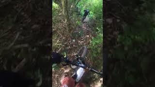
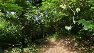
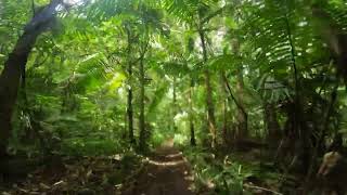
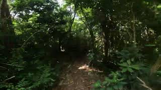
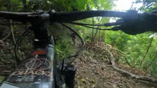
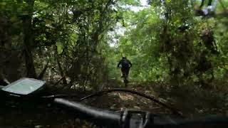
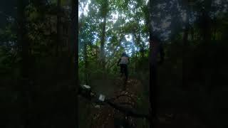
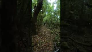
Photos of Puerto Plata Mountain Bike
Videos of Puerto Plata Mountain Bike
trail: Gran Diablo
0:18 |
159 |
Aug 16, 2024 , Puerto Plata
trail: Cucalacran
3:39 |
118 |
Aug 8, 2024 , Puerto Plata
trail: Cucalacran
5:33 |
94 |
Aug 8, 2024 , Puerto Plata
trail: El Disparo
0:15 |
88 |
Aug 8, 2024 , Puerto Plata
trail: El Disparo
0:41 |
96 |
Aug 8, 2024 , Puerto Plata
trail: El Disparo
0:09 |
91 |
Aug 8, 2024 , Puerto Plata
trail: Gran Diablo
0:56 |
97 |
Aug 5, 2024 , Puerto Plata
trail: Gran Diablo
0:30 |
69 |
Aug 5, 2024 , Puerto Plata
Recent Trail Reports
| status | trail | date | condition | info | user |
|---|---|---|---|---|---|
| Little Window | Mar 1, 2025 @ 11:47am Mar 1, 2025 | Snow Groomed | pfchurchill LA VESTA | ||
| Cucalacran | Aug 1, 2024 @ 6:39pm Aug 1, 2024 | Variable | mariodelamaza | ||
| Rocas del Diablo | Jul 31, 2024 @ 7:46am Jul 31, 2024 | Dry | mariodelamaza | ||
| El Callejon De La Loma | Jul 31, 2024 @ 7:44am Jul 31, 2024 | Dry | mariodelamaza | ||
| La Torre | Jul 31, 2024 @ 6:32am Jul 31, 2024 | Dry | mariodelamaza | ||
| Gran Diablo | Jul 31, 2024 @ 6:31am Jul 31, 2024 | Variable | mariodelamaza | ||
| Red October | Jul 1, 2024 @ 10:16am Jul 1, 2024 | Ideal | Mario9H2XdS | ||
| MI Ghost Connector | May 19, 2024 @ 7:48am May 19, 2024 | Unknown | JeanFrancoisnpL6g8 | ||
| Sosua Abajo | Apr 6, 2024 @ 9:15am Apr 6, 2024 | Ideal | Mario9H2XdS | ||
| Panorama via El Choco | Apr 6, 2024 @ 9:15am Apr 6, 2024 | Variable | Mario9H2XdS |
Activity Feed
| username | action | type | title | date |
|---|---|---|---|---|
| bobbiejamie | wishlist | region | activity #92261760 | Apr 9, 2026 @ 10:06am Apr 9, 2026 |
| Mario9H2XdS | add | trail | activity #92245051 and 3 more | Apr 9, 2026 @ 4:48am Apr 9, 2026 |
| Mario9H2XdS | add | trail | activity #91579169 and 2 more | Mar 30, 2026 @ 4:48am Mar 30, 2026 |
| Mario9H2XdS | add | trail | activity #91472995 and 5 more | Mar 28, 2026 @ 2:43pm Mar 28, 2026 |
| Mario9H2XdS | comment | trail | activity #91367854 | Mar 27, 2026 @ 4:44am Mar 27, 2026 |
Recent Comments
| username | type | title | comment | date |
|---|---|---|---|---|
| trail | theres a gate but always open | Mar 27, 2026 @ 4:44am Mar 27, 2026 | ||
| trail | Riding this almost everyday, great trail, also... | Jul 31, 2024 @ 7:54am Jul 31, 2024 | ||
| trail | Excelente | Jan 19, 2022 @ 12:43pm Jan 19, 2022 | ||
| trail | Excelente | Jan 19, 2022 @ 12:43pm Jan 19, 2022 | ||
| trail | The part on top of the mountain where the dirt... | Feb 12, 2021 @ 7:34pm Feb 12, 2021 |
Local Badges
-

Completionist0 awarded -

Big Ride 30k129 awarded -

Epic Ride 50k40 awarded -

Top 10 Trails0 awarded -

10 Black Trails1 awarded -

10 Expert Trails1 awarded
Activity Type Stats
| activitytype | trails | distance | descent | descent distance | total vertical | rating | global rank | state rank | photos | reports | routes | ridelogs |
|---|---|---|---|---|---|---|---|---|---|---|---|---|
| Mountain Bike | 342 | 402 miles | 65,069 ft | 196 miles | 3,212 ft | #405 | #1 | 56 | 33 | 928 | ||
| E-Bike | 271 | 35 miles | 4,790 ft | 16 miles | 1,158 ft | #708 | #1 | 27 | 150 | |||
| Gravel Bike | 3 | #219 | #3 | |||||||||
| Horse | 16 | 25 miles | 3,235 ft | 11 miles | 1,129 ft | 8 | 1 | |||||
| Hike | 331 | 366 miles | 60,827 ft | 184 miles | 3,212 ft | #242 | #1 | 33 | 143 | |||
| Trail Running | 330 | 362 miles | 60,479 ft | 183 miles | 3,212 ft | #183 | #1 | 33 | 15 | |||
| Dirtbike/Moto | 145 | 396 miles | 58,888 ft | 189 miles | 3,212 ft | #23 | #1 | 11 | 2 | 268 | ||
| ATV/ORV/OHV | 11 | 8 |
Frequently Asked Questions About Puerto Plata
▼
What are the best places to ride in Puerto Plata?
Puerto Plata has 2 areas to explore for mountain biking. The top rated areas are:
▼
What are the highest rated mountain biking trails in Puerto Plata?
The highest rated mountain biking trails in Puerto Plata are:
- Gran Diablo (4.1/5)
- Fenceline to Aguacate (4.1/5)
- La Torre (4.1/5)
- Little Window (4.1/5)
- Don-Juan Sleep in the Jungle (4.1/5)
▼
What is the best time of the year to ride in Puerto Plata?
Based on ride log data, the most popular months to ride in Puerto Plata are:
- February (47 activities)
- March (23 activities)
- April (17 activities)
▼
Where can I park to ride in Puerto Plata?
There are 2 parking locations listed in Puerto Plata. The most popular parking spots are:
Activities
Trails
- By madmaxxx999 & contributors
- Admins: elyari
- #15384 - 4,523 views
- puerto plata activity log | embed map of Puerto Plata mountain bike trails | puerto plata mountain biking points of interest
Downloading of trail gps tracks in kml & gpx formats is enabled for Puerto Plata.
You must login to download files.