close
-
Layers w
- Weather Layers
- Pro
- Pro
- Pro
- Pro
- Pro
- Pro
- More Layers
- Pro
- Pro
- Pro
- Pro
-
Upgrade to

3D
Trail Conditions
- Unknown
- Snow Groomed
- Snow Packed
- Snow Covered
- Snow Cover Partial
- Freeze/thaw Cycle
- Icy
- Prevalent Mud
- Wet
- Variable
- Ideal
- Dry
- Very Dry
Trail Flow (Ridden Direction)
Trailforks scans users ridelogs to determine the most popular direction each trail is ridden. A good flowing trail network will have most trails flowing in a single direction according to their intension.
The colour categories are based on what percentage of riders are riding a trail in its intended direction.
The colour categories are based on what percentage of riders are riding a trail in its intended direction.
- > 96%
- > 90%
- > 80%
- > 70%
- > 50%
- < 50%
- bi-directional trail
- no data
Trail Last Ridden
Trailforks scans ridelogs to determine the last time a trail was ridden.
- < 2 days
- < 1 week
- < 2 weeks
- < 1 month
- < 6 months
- > 6 months
Trail Ridden Direction
The intended direction a trail should be ridden.
- Downhill Only
- Downhill Primary
- Both Directions
- Uphill Primary
- Uphill Only
- One Direction
Contribute Details
Colors indicate trail is missing specified detail.
- Description
- Photos
- Description & Photos
- Videos
Trail Popularity ?
Trailforks scans ridelogs to determine which trails are ridden the most in the last 9 months.
Trails are compared with nearby trails in the same city region with a possible 25 colour shades.
Think of this as a heatmap, more rides = more kinetic energy = warmer colors.
- most popular
- popular
- less popular
- not popular
ATV/ORV/OHV Filter
Max Vehicle Width
inches
US Cell Coverage
Legend

Radar Time
Activity Recordings
Trailforks uses anonymized public activity data.
?
Activity Recordings
Trailforks uses anonymized public activity data.
?
Personal Heatmap
▶
Activity Types
all
/
none
▶
Options
2
Date range
month
–
Winter Trails
Warning
A routing network for winter maps does not exist. Selecting trails using the winter trails layer has been disabled.
Missing Trails
Most Popular
Least Popular
Trails are colored based on popularity. The more popular a trail is, the more red. Less popular trails trend towards green.
Jump Magnitude Heatmap
Heatmap of where riders jump on trails. Zoom in to see individual jumps, click circles to view jump details.
BC Backroad Status
![map legend]()
Service Road Atlas is a free to use, community-driven service for viewing and creating reports on the numerous back-country service roads around B.C. and Alberta.

Slope Aspect
Direction the slope faces
Trails Deemphasized
Trails are shown in grey.
Only show trails with no bike usage.
Suggested Layers
Based on selected activity type
Save the current map location and zoom level as your default home location whenever this page is loaded.
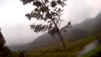
SavePopular riding destination for a lot of mountain biker from Jakarta, Bogor and Cianjur.
Primary Trail Type: All-Mountain & Downhill
Shuttleable: YES
Access Info:
Warung Mang Ade.
Activities Click to view
- Mountain Bike
36 trails
- Hike
6 trails
- Trail Running
6 trails
Bike Park Details
- 12
- 5
- 12
- 7
Region Status
Open as of Nov 27, 2021- Day Ticket
- 25000 IDR
- Uplift Type
- Shuttle
Stats
- Avg Trail Rating
- Trails (view details)
- 36
- Trails Mountain Bike
- 36
- Trails E-Bike
- 3
- Trails Hike
- 6
- Trails Trail Running
- 6
- Trails Dirtbike/Moto
- 2
- Total Distance
- 44 miles
- Total Descent
- 18,783 ft
- Total Vertical
- 4,011 ft
- Highest Trailhead
- 5,099 ft
- Reports
- 28
- Photos
- 201
- Ridden Counter
- 371
Popular Puncak Mountain Biking Trails
• 5 ★ 5.0 • 3,048 ft • 0 ft • 31 •
Less popular black diamond difficulty singletrack. This mountain bike primary trail can be used downhill only and has a moderate overall physical rating. It features berm, bridge, drop and jump. On average it takes 9 minutes to complete this trail.
• 5 ★ 0.0 • 3 miles • 375 ft • 24 •
What can I say? The complete package if you just wanna go mountain biking.
• 5 ★ 0.0 • 852 ft • 33 ft • 22 •
Less popular green difficulty singletrack. This mountain bike primary trail can be used both directions and has a easy overall physical rating. On average it takes 1 minutes to complete this trail.
• 5 ★ 5.0 • 1 mile • 158 ft • 22 •
Shorter but steeper alternative to . Lots of technical sections.
• 90 ★ 0.0 • 952 ft • 36 ft • 20 •
Alternate exit route after the old one has been destroyed by landslides.
• 5 ★ 5.0 • 4,414 ft • 26 ft • 18 •
Less popular black diamond difficulty singletrack. This mountain bike primary trail can be used downhill primary. On average it takes 5 minutes to complete this trail.
• 5 ★ 0.0 • 3 miles • 19 ft • 14 •
Less popular blue difficulty mixed. This mountain bike primary trail can be used downhill primary. On average it takes 22 minutes to complete this trail.
• 5 ★ 0.0 • 318 ft • 17 ft • 12 •
Less popular green difficulty singletrack. This mountain bike primary trail can be used both directions. On average it takes 1 minutes to complete this trail.
Puncak Mountain Bike Routes
24 miles • 2,370 ft • 3 • Point to Point •
This route is on another side of Puncak Area. Starting from Cipanas, it descend all the way down to...
15 miles • 1,310 ft • 2 •
-------------------------------------------------------------
4 miles • 387 ft • 2 • Point to Point • Race •
Rute balapan Jelanus MTB Race Seri 1. Format All-mountain race, mass start, point-to-point.
13 miles • 2,174 ft • 10 • Loop • Race •
The race course for the Asian Enduro Series Warm Up Race 2015.
12 miles • 1,997 ft • 9 • Point to Point • Race •
Race course for Asian Enduro Series Warm Up Event. 3-4 October 2015. May subject to change.
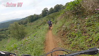
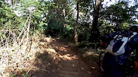
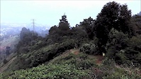
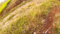
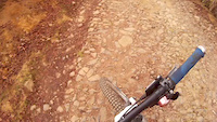
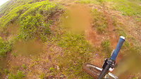
Photos of Puncak Mountain Bike
Videos of Puncak Mountain Bike
trail: KTH AT
0:21 |
94 |
Apr 5, 2021
trail: KTH AT
0:30 |
139 |
Aug 12, 2019
trail: KTH AT
0:46 |
180 |
Sep 13, 2016
trail: KTH Wisata-2
2:27 |
48 |
Aug 15, 2015
trail: TW Access Road
2:49 |
49 |
Aug 15, 2015
trail: KTH Wisata-2
3:23 |
46 |
Aug 15, 2015
trail: KTH Wisata-2
2:02 |
33 |
Aug 15, 2015
trail: NuRA
7:32 |
108 |
May 15, 2015
Recent Trail Reports
| status | trail | date | condition | info | user |
|---|---|---|---|---|---|
| KTH AT | Oct 6, 2021 @ 8:52pm Oct 6, 2021 | Ideal | rifu | ||
| Nu AT | Apr 2, 2021 @ 6:18pm Apr 2, 2021 | Wet | kustyawan | ||
| KTH LB | Nov 13, 2020 @ 4:07pm Nov 13, 2020 | Variable | Mrqmrc | ||
| NuRA | Mar 6, 2020 @ 4:41pm Mar 6, 2020 | Prevalent Mud | ekoprobo | ||
| Kebun Coklat 2 | Jul 21, 2019 @ 1:20pm Jul 21, 2019 | Dry | ejbhakti | ||
| KTH AT extension | Apr 5, 2019 @ 8:30pm Apr 5, 2019 | Wet | ejbhakti | ||
| Aquila | Jul 29, 2017 @ 7:01pm Jul 29, 2017 | Dry | Adiktadito | ||
| Kebun Coklat 1 | Jul 16, 2017 @ 11:32pm Jul 16, 2017 | Unknown | JanaKusuma | ||
| Karmel | Jul 16, 2017 @ 11:32pm Jul 16, 2017 | Unknown | JanaKusuma |
Activity Feed
| username | action | type | title | date |
|---|---|---|---|---|
| DY7LzC | wishlist | trail | activity #89682860 | Feb 28, 2026 @ 5:06am Feb 28, 2026 |
| j4mess | ridden | trail | activity #79172131 and 1 more | Aug 29, 2025 @ 6:31am Aug 29, 2025 |
| j4mess | ridden | trail | activity #76872929 | Jul 27, 2025 @ 9:54pm Jul 27, 2025 |
| StefanGabel | wishlist | trail | activity #54706886 and 4 more | Jun 25, 2024 @ 10:06pm Jun 25, 2024 |
| todd | update | trail | activity #49646679 and 1 more | Feb 29, 2024 @ 1:59pm Feb 29, 2024 |
Recent Comments
| username | type | title | comment | date |
|---|---|---|---|---|
| trail | @rifu...yaela pakai rahasia segala... :) | May 3, 2016 @ 2:36am May 3, 2016 | ||
| trail | @nardex ada deeeh :p | May 2, 2016 @ 8:00pm May 2, 2016 | ||
| trail | Mantab...ini jalur yg nanti buat Race Enduro... | May 1, 2016 @ 10:28pm May 1, 2016 |
Nearby Areas
| name | distance | ||||
|---|---|---|---|---|---|
| Cihideung Gravity Park | 1 | 15.2 km | |||
| Cibubur | 22.4 km | ||||
| Hutan UI Bike Park | 1 | 1 | 26.5 km | ||
| Cikarang | 33.4 km | ||||
| Serpong | 1 | 2 | 36.4 km |
Local Badges
-

Completionist0 awarded
Activity Type Stats
| activitytype | trails | distance | descent | descent distance | total vertical | rating | global rank | state rank | photos | reports | routes | ridelogs |
|---|---|---|---|---|---|---|---|---|---|---|---|---|
| Mountain Bike | 36 | 44 miles | 18,783 ft | 25 miles | 4,012 ft | #1,261 | #2 | 201 | 28 | 9 | 500 | |
| E-Bike | 3 | 4 miles | 974 ft | 1 mile | 1,001 ft | 24 | 8 | |||||
| Hike | 6 | 5 miles | 1,427 ft | 2 miles | 1,260 ft | #1,987 | #7 | 28 | 9 | |||
| Trail Running | 6 | 5 miles | 1,427 ft | 2 miles | 1,260 ft | #1,320 | #7 | 28 | 6 | |||
| Dirtbike/Moto | 2 | 2 miles | 49 ft | 1,155 ft | 974 ft | 15 |
Frequently Asked Questions About Puncak
▼
What are the highest rated mountain biking trails in Puncak?
The highest rated mountain biking trails in Puncak are:
- KTH AT extension (4.1/5)
- KTH AT (4.1/5)
- KTH LB (4.1/5)
- RA Klasik (4/5)
- KTH Wisata-2 (4/5)
▼
What is the best time of the year to ride in Puncak?
Based on ride log data, the most popular months to ride in Puncak are:
- June (5 activities)
- November (4 activities)
- July (4 activities)
▼
Where can I park to ride in Puncak?
Check the Puncak trail map for trailhead and parking information. Community members regularly update access and parking details for trails in the area.
▼
What is the longest trail in Puncak?
The longest trail in Puncak is Kebun Coklat 1 at 5.1 km. View all trails sorted by distance.
- By rifu
 & contributors
 - Admins: apply
- #4626 - 9,371 views
- puncak activity log | embed map of Puncak mountain bike trails | puncak mountain biking points of interest
Downloading of trail gps tracks in kml & gpx formats is enabled for Puncak.
You must login to download files.